What's the Farthest Distance a Contrail is Visible at?

I doubt that was the plane. If you could see that trail (how wide was it likely?) what other things the same width ought you see that far away? (It'd take a telescope to see anything that far away besides the coast range mountains)
More likely to me, it proves that there's trails out there that you can't identify.
I have no doubt that was the right plane.

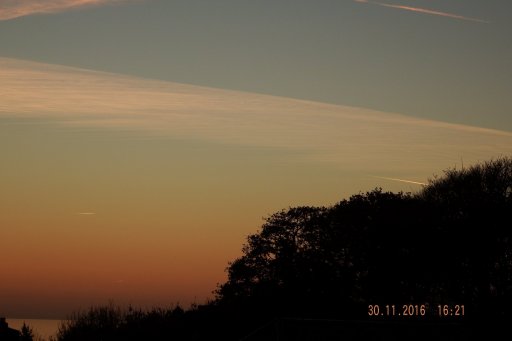
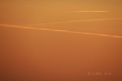
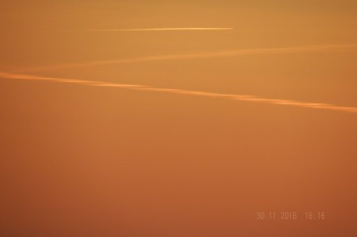
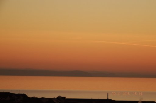
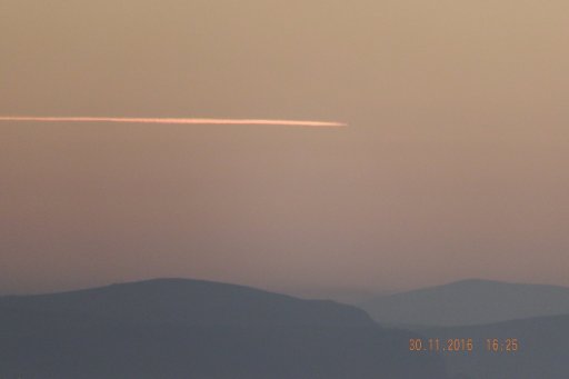
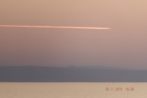
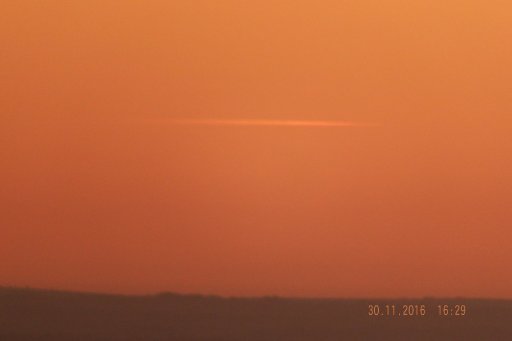
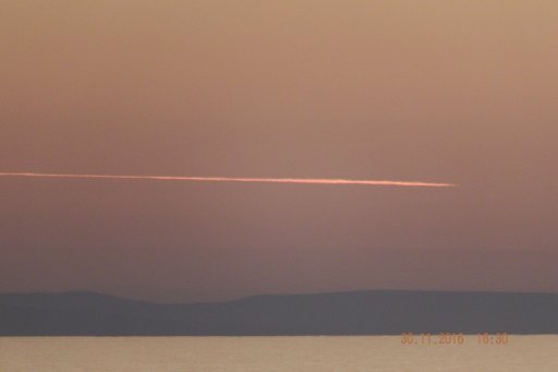
I have a clear view to the west from my bedroom window. I can watch planes that fly nearly overhead as they head west towards America and can often see still see their contrails with the naked eye when they are over Wales, 100 miles or more away – even when the contrails are relatively short.

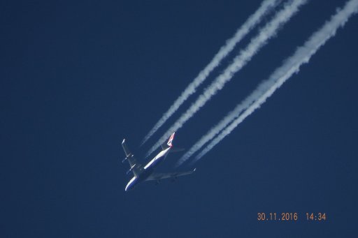
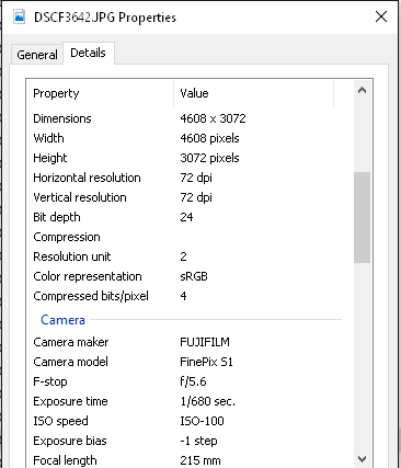
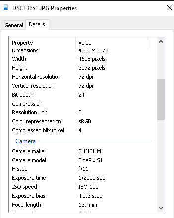
See for instance this post in this thread. The plane passed only a few miles to my north so I was able to watch it all the way and ensure it was the same plane. That photo was taken when it was 125 miles away.

It's easier close to sunset as the trails shine out against the surrounding sky.

1946.PNG
 
Last edited:
About 170 miles if so.

I think it's probably the closer one, in the middle. 170 miles would put a contrail very close to the horizon. The 120 mile contrails I see are seem practically level with me.

It's also more at right angles to your view line, which matches the flat angle.
 
I think it's probably the closer one, in the middle. 170 miles would put a contrail very close to the horizon. The 120 mile contrails I see are seem practically level with me.

It's also more at right angles to your view line, which matches the flat angle.

I agree that it does not seem low enough... however the track is close to parallel
to the horizon, which means that the track is perpendicular to the line between Aberystwyth and somewhere near Cardigan, which is at the end of the headland you can see near the sun. EIN594H should be dropping relative to the horizo n. (as far as I can tell by eyeballing FR24..) Bonus points for anyone who spotted the dolphin and a (very weak) green flash in no. 3.
 
I think it's probably the closer one, in the middle. 170 miles would put a contrail very close to the horizon. The 120 mile contrails I see are seem practically level with me.

It's also more at right angles to your view line, which matches the flat angle.

Probably right. I did think it was a bit far. That would be almost exactly 100 miles from Aberystwyth if it was the nearer one.

Clouds Givemethewillies said:
Bonus points for anyone who spotted the dolphin and a (very weak) green flash in no. 3.

I see the flash.... and a couple of gulls, but no dolphin!
 
Red is Aer Lingus (the closer flight). Over the sun and flat at :07

20161129-110350-umibu.jpg
 

Attachments

  • wales low contrails.kmz
    8.9 KB · Views: 644
I would say 233 degrees true, but I am not very good with Google Earth, and I am not sure how much is below the sea, but Cardigan Island would be about right. I saw a few planes around there, but waited until I got one in line.
 
I would say 233 degrees true, but I am not very good with Google Earth, and I am not sure how much is below the sea, but Cardigan Island would be about right. I saw a few planes around there, but waited until I got one in line.
This would make UAE205 the most likely candidate with an estimated distance to the plane of about 230 miles. Will measure on Google Earth later, when the flight is completed.
 
uae205 distant.PNG This screen capture file has a time of 4:33 (UTC)
UAE205 has not arrived to New York yet, but I've looked into the flight track log. At the time of the photo (Wed 04:30:49 PM GMT), the plane's coordinates were 50.2777 -8.3817. This is at the right heading from you location and at the distance of about 236 miles (205 NM):
Screen Shot 2016-11-30 at 21.05.08.png

When KML file of the track is available, it can be viewed on Google Earth from your location and compared with the photo directly.
 
Last edited:
This would make UAE205 the most likely candidate with an estimated distance to the plane of about 230 miles. Will measure on Google Earth later, when the flight is completed.

You can get the google earth file before a plane has landed, just add /google_earth to the full URL of the flight in Flightaware.

eg:
https://flightaware.com/live/flight/UAE205/history/20161130/1440Z/LIMC/KJFK
https://flightaware.com/live/flight/UAE205/history/20161130/1440Z/LIMC/KJFK/google_earth
 

Attachments

  • FlightAware_UAE205_LIMC_KJFK_20161130.kml
    42.3 KB · Views: 760
UAE205 has not arrived to New York yet, but I've looked into the flight track log. At the time of the photo (Wed 04:30:49 PM GMT), the plane's coordinates were 50.2777 -8.3817. This is at the right heading from you location and at the distance of about 236 miles (205 NM):
Screen Shot 2016-11-30 at 21.05.08.png

Are the more distant (and further west) headlands over the horizon from your viewpoint, CGMTW?
 
Thanks. I have not found a way to zoom Google Earth while staying at the correct location. All I can get is this:cardigan.PNG
I have added your photo to Google Earth, assuming the horizontal FOV is about 2°. This gives a good match for the land, but the contrail is higher than the track. The discrepancy probably is due to refraction.
UAE205 contrail.jpg

The sun position at 4:05 PM GMT and the plane position at 4:31PM match the geography quite well.

What is the actual FOV of your photo? If it and the photo of the setting sun are at the same focal length, it is probably a bit more than 2° (4.7 diameters of the Sun):
farthest contrail.jpg
 
Last edited:
I have added your photo to Google Earth, assuming the horizontal FOV is about 2°. This gives a good match for the land, but the contrail is higher than the track. The discrepancy probably is due to refraction.
UAE205 contrail.jpg

The sun position at 4:05 PM GMT and the plane position at 4:31PM match the geography quite well.

What is the actual FOV of your photo? If it and the photo of the setting sun are at the same focal length, it is probably a bit more than 2° (4.7 diameters of the Sun):
farthest contrail.jpg

Amazing forensic trail mapping skills, orders of magnitude better than CTers.

I will try to get information about the camera later today.

Remember that the KML file shows barometric alitude 36,00ft.= 11km. = 226.00Hpa - https://en.wikipedia.org/wiki/International_Standard_Atmosphere
so it was actually flying at 226Hpa which was about 11159 km.
http://weather.uwyo.edu/cgi-bin/sou...AR=2016&MONTH=12&FROM=0100&TO=0100&STNM=03808
It only accounts for a small error in this case, but should be bourne in mind.
 
Is this also a contrail, but unlit? It looks like it, but I can't really see how it can be, because if it appears lower, and therefore more distant, so therefore it ought to be more sunlit.

upload_2016-12-1_10-38-28.png
 
Is this also a contrail, but unlit? It looks like it, but I can't really see how it can be, because if it appears lower, and therefore more distant, so therefore it ought to be more sunlit.

upload_2016-12-1_10-38-28.png
I did notice it, but as you say it should be lit, if a contrail. I guess it is the aerosols at the top of the (low) boundary layer swelling with higher humidity levels there. - cloud formed later.
Unfortunately this is broken at the time, but you can see the low aerosol/boundary layer.
 
Here are some more photos from around that time, for hard-line Google Earthers. + sun today at 100x zoom through welding glass, for camera calibration.DSCF3675.JPG DSCF3676.JPG
 

Attachments

  • DSCF3677.JPG
    DSCF3677.JPG
    128.9 KB · Views: 467
  • DSCF3674.JPG
    DSCF3674.JPG
    88.7 KB · Views: 458
  • DSCF3673.JPG
    DSCF3673.JPG
    87.5 KB · Views: 423
  • DSCF3672.JPG
    DSCF3672.JPG
    90.6 KB · Views: 468
  • DSCF3684.JPG
    DSCF3684.JPG
    138.1 KB · Views: 445
  • DSCF3685.JPG
    DSCF3685.JPG
    134.5 KB · Views: 430
  • DSCF3686.JPG
    DSCF3686.JPG
    138.7 KB · Views: 445
  • DSCF3687.JPG
    DSCF3687.JPG
    147.8 KB · Views: 453
  • DSCF3695[1].JPG
    DSCF3695[1].JPG
    73.3 KB · Views: 587
Last edited:
I have added your photo to Google Earth, assuming the horizontal FOV is about 2°. This gives a good match for the land, but the contrail is higher than the track. The discrepancy probably is due to refraction.
UAE205 contrail.jpg

The sun position at 4:05 PM GMT and the plane position at 4:31PM match the geography quite well.

What is the actual FOV of your photo? If it and the photo of the setting sun are at the same focal length, it is probably a bit more than 2° (4.7 diameters of the Sun):
farthest contrail.jpg

This is what it says for the 'record' photo (3688). I know this other photo of a plane(3642) was 100X, as usual for plane photos. The 'record' photo might be 50x optical, and the plane 50x optical, 2x digital, although the resolution/file size should be different, in that case. The sunset photo is dsc3651
3688.PNG
 

Attachments

  • DSCF3642.JPG
    DSCF3642.JPG
    128.5 KB · Views: 451
  • 3642.PNG
    3642.PNG
    11 KB · Views: 461
  • sun.PNG
    sun.PNG
    9.9 KB · Views: 450
Last edited:
This is what it says for the 'record' photo (3688). I know this other photo of a plane(3642) was 100X, as usual for plane photos. The 'record' photo might be 50x optical, and the plane 50x optical, 2x digital, although the resolution/file size should be different, in that case. The sunset photo is dsc3651

The full zoom focal length of your camera (215 mm) corresponds to 1200 mm in 35 mm equivalent. It gives the horizontal FOV of 1.72°, 2x digital would half it to 0.86°.

The sunset photo's focal length 139 mm corresponds to 776 mm, or the horizontal FOV of 2.66°. It is about right (~5 Sun angular diameters).

It was possible to fit your photo for both FOV of 1.72° and 0.86° as the wedge-shaped piece of visible land scales well. In both fits, the trail remained above the track. They come together only at the horizontal FOV of about 0.40° (4x digital zoom). At these tiny angles the fitting results strongly depend on the exact location of the camera, particularly, its altitude above the ground/sea level.

I normally use 51 metres for SHCC when it was down at ground level. The photo might have been a couple of metres lower. The plane refraction should be about the same as for the sun as both paths go through most of the atmosphere., but it should be less for the horizon as the path is much shorter, IMO.

edit ps. I have not been able to digitally zoom more than 2x with the camera. I use 'P' mode to even get that choice.

50x optical 2x digital https://www.metabunk.org/attachments/dscf3695-1-jpg.23179/
 
Last edited:
I normally use 51 metres for SHCC when it was down at ground level. The photo might have been a couple of metres lower. The plane refraction should be about the same as for the sun as both paths go through most of the atmosphere., but it should be less for the horizon as the path is much shorter, IMO.

edit ps. I have not been able to digitally zoom more than 2x with the camera. I use 'P' mode to even get that choice.

50x optical 2x digital https://www.metabunk.org/attachments/dscf3695-1-jpg.23179/
At the eye altitude of 49 m above sea level and horizontal FOV of 0.86°, the contrail is about the same height above the horizon as the track, but the land piece height in Google Earth is about twice the height in the photo:
Screen Shot 2016-12-01 at 19.51.16.png
 
Congratulations on the long range spotting! I had calculated 219 miles sans distortion...
It was for 30000 ft (6 miles) altitude, whereas UAE205 was at a higher altitude of 36000 ft (7 miles). For this altitude your formula gives about 236 miles, that is very close to the observed distance.:cool:
 
It was for 30000 ft (6 miles) altitude, whereas UAE205 was at a higher altitude of 36000 ft (7 miles). For this altitude your formula gives about 236 miles, that is very close to the observed distance.:cool:

Jay used some approximate numbers:


h = altitude of the contrail ~6 miles(31,200ft)
r = 4000 miles(radius of the earth)
then d = (the square root of) (6X6)+ 2(4000)(6)
d= distance that a contrail would be visible
d=219 miles

Content from External Source
You can just stick in the Viewer height into a horizon calculator for a more accurate number, 36000 feet gives a horizon distance of 232 miles.

https://www.metabunk.org/curve/?d=1&h=36000&r=3959&u=i&a=n&fd=60&fp=3264

if you get a plane at FL450 that extends it to 260 miles.
 
And what would the distance be for the observer being at 50 meters above sea level?

about 248 miles

The maximum visible distance from you to a plane is your distance to the horizon plus the plane's distance to the horizon. You can just do the horizon calculation twice, or for view height h and plane height p, it's
sqrt(h*h+2*r*h) + sqrt(p^p+2*r*p)
 
Last edited:
At the eye altitude of 49 m above sea level and horizontal FOV of 0.86°, the contrail is about the same height above the horizon as the track, but the land piece height in Google Earth is about twice the height in the photo:
Screen Shot 2016-12-01 at 19.51.16.png
I found a good match for the land but lost the track..
I needed to set 50m above _sea level_ to get a good match to the view from my window,distant.PNG
 
I found a good match for the land but lost the track..
But you set FOV of 1.86° (no digital zoom) and got about the same fit as I did in the first attempt above (#62). I have reproduced your fit, the trail is still about twice higher than the track.

Perhaps it was a secret sprayer deployed to thwart you record attempt by flying parallel to UAE205 and closer to your location ;)
Or there was an atmospheric refraction lifting up the trail appearance by a small fraction of one degree…
 
Back
Top