Here's my analysis of the Camera 1 video:
Location: Bat Yam, Israel - Looking generally south. Maybe 190 degrees...
The two buildings on the left edge of the frame are:
Taller and closer to camera: The Sunset Beach Hotel (This name is my best guess. This property seems to have a troubled history and doesn't appear to be open. No lights. But I think that's the name.)
Shorter and farther from camera, with vertical line of windows: Beach Colony Apts.
The most likely camera position: Somewhere (perhaps the roof) on The Arena Hotel By The Beach.
Note The Sunset Beach Hotel to the south. I chose the Arena Hotel building as the most likely camera position because there's no taller building between it and the The Sunset Beach Hotel. Also, the Arena Hotel is not visible in the camera frame.
Analysis of what is within the camera frame, and line of sight to Qassam rocket launch site:
In the Camera 1 view, we are looking generally SSW. The left side of the frame is on the east and the right side is on the west.
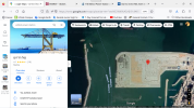
I've added some lines to the Google Earth View of this area. The top of this map is south. The lines diverge from the Arena Hotel. The line on our left (east side of this map) represents the left side of the Camera 1 video frame. Nothing to the left (east) of this line would be visible in the frame.
The line on our right (west) stretches all the way to the Qassam rocket launch site in Gaza.
Identification of lights marked by red arrows: The Port of Ashdod, Israel
Note that the Port of Ashdod is within the frame. The Port is closer to Camera 1 than is the City proper. The Port mostly hides the lights of the City of Ashdod.
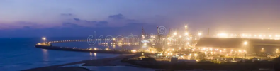
The Port of Ashdod at night. Lots of lights.
The Eshkol Power Station is in the Port area.
Cranes on the north side of the Port, nearest to Camera 1
So, lot's of tall structures such as cranes and smokestacks which must have lots of lights, including blinking lights.
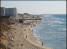
Daytime tourist photo from the Arena Hotel. We can see the Port of Ashdod, the power plant, and so on.
The line of sight to the launch site goes right by the far end of the main breakwater.
I think that fits pretty well with the position of the Qassam rockets in boost phase relative to the lights of the Port of Ashdod, seen here.
B is the location of the hospital. you can see the second ground explosion there, 7 seconds after the rocket explodes, if you watch the al jazeera segment. the WSJ thing doesn't show it
Does "B" mark the light from the explosion at the hospital?: No.
Reason 1: The hospital is 38.8 miles from the camera. In the best of conditions would this mediocre camera be capable of seeing such a faint light at that distance; mostly hidden from sight by the hospital buildings and other ground clutter? Maybe.
But in this multi-generation video, there are a lot of compression artifacts and few pixels, which makes it even more doubtful we could pick out such a distant explosion mixed in with the bright ground lights.
What about the rockets? Why can we see them so clearly? Rocket exhaust is much brighter. A factor of one hundred? A thousand? They are also seen in the dark sky. Not comparable.
Reason 2: Even on a Flat Earth there's too much ground clutter between the camera and Gaza. I don't think we see much of the City of Ashdod itself. The Port is in the way. Let alone Gaza.
Reason 3: The explosion is hidden by the curvature of the Earth.
Earth's Curve Horizon, Bulge, Drop, and Hidden Calculator
https://www.metabunk.org/curve/
Distance in Miles: 38.8
Viewer height in Feet: 250
Geometric results (no refraction)
Geometric Horizon = 19.36 miles (102234.16 feet)
Geometric Drop = 1003.9 feet (12046.85 inches)
Geometric Hidden= 251.94 feet (3023.27 inches)
Geometric Horizon Dip = 0.280 Degrees, (0.0049 Radians)
In the best of conditions we would only be able to see some light from the explosion diffusely reflected from clouds.
Conclusion: You were looking at blinking lights on tall structures in the Port of Ashdod area and/or compression artifacts.