U-turn contrail

derwoodii

Senior Member.
Over Latrobe valley Victoria from top of Mt Baw Baw today. I wondered whats up as bit to far for approach turn about hold pattern. It dissipated fast but then quite a few more popped and i was able to snap a jet with out contrail as it passed over. The sun had a nice halo effect going on as well & yes snow skiing was tip top too.

IMGP2943.JPG
my camera times is out by 1 hour
IMGP2948.JPG

Ok pathetic snap yes but i was on skis with gloves and only just heard it above me

IMGP2951.JPG

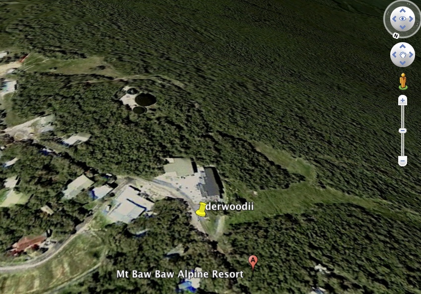
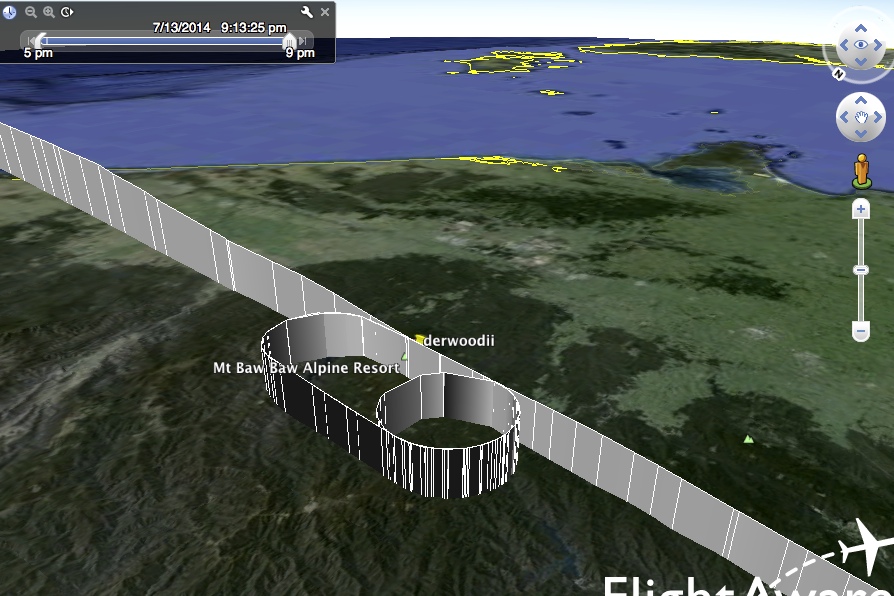
heres the location and time was 10.00 to 11.30am 14/7/14
bawbaw.PNG
 
Aircraft can do a hold hundreds of miles from their destination.

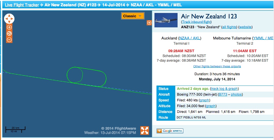
That looks almost like a single 360° turn, given to that flight, as part of a 'sequencing' tactic by ATC.

We do not always have to enter a full Holding Pattern...on occasion, ATC will just ask for one 360° turn...adds maybe 4 or 6 minutes, to provide spacing for other traffic, and to prevent future conflicts.

AND yes....have been asked many times to do this AT CRUISE ALTITUDE.

Controllers will try to change other flights' airspeeds to eliminate this request....but, when others cannot or WILL not comply, then sometimes a simple 360 is a solution.
 
Last edited:
yes i kinda thought as much i was under a east west path that mostly serves OZ - NZ so suspect 2 flights both on hold while clear Melbourne's Tullamarine Airport approach
 
Melbourne's Tullamarine Airport approach

I tried using FlightAware to find actual Charts for YMML....but, unfortunately, all they have (so far) is a Google Earth image:
http://flightaware.com/resources/airport/YMML/map

"FA" is a good source for a lot of pilot-friendly paperwork, in order to show to non-pilots. Perhaps "TWCobra" has a few Jeppesen pages for
YMML that he could upload....specifically, any of the STARs that might be appropriate?
 
U-turns could be called for in the case of unexpected prohibitive weather at the destination, and the airline elects to return to origin rather than divert somewhere else.
This happens between Auckland and Christchurch. The development of fog unexpectedly at Christchurch will result in AKL-CHC flights doing a U-turn to return to Auckland.

There was a case of this on 19 July 2010, much celebrated by the local chemtrail community.
https://chemtrailsnorthnz.wordpress.com/2010/07/30/good-video-footage-of-chemtrails-over-nelson/
and see the link to stills here:
http://chemtrailsoverkaikoura.ning.com/photo/photo/slideshow?albumId=4744723:Album:3355

Here are the METAR from NZCH showing why these aircraft made U-turns.

METAR NZCH 181700Z 04005KT 9999 BKN010 05/04 Q1015 TEMPO BKN009 RMK RMK SUGARLOAF 11005KT
METAR NZCH 181800Z 33004KT 9999 BKN010 03/02 Q1015 BECMG SCT020 TEMPO BKN009 RMK SPECI CLD SUGARLOAF 27006KT
METAR NZCH 181900Z 29003KT 9999 FEW010 02/02 Q1015 TEMPO BKN009 RMK MIFG SPECI CEASES SUGARLOAF 25008KT
METAR NZCH 182000Z 23005KT 9999 FEW010 02/01 Q1016 TEMPO TL2100 BKN009 RMK SUGARLOAF 26010KT
METAR NZCH 182100Z 22003KT 0400 FG SCT010 02/02 Q1016 BECMG 9999 NSW TEMPO 0500 FG BKN002 RMK SPECI VIS SUGARLOAF 26013KT
METAR NZCH 182200Z 23003KT 200V260 0200 FG VV/// 03/03 Q1017 BECMG FM2300 9999 NSW RMK SPECI VIS SUGARLOAF 27016KT
NZCH 182300Z MISSING
METAR NZCH 190000Z 28002KT 0700 0500W FG VV/// 05/05 Q1016 BECMG 9999 NSW RMK SPECI VIS SUGARLOAF 29009KT
METAR NZCH 190100Z 36002KT 9999 BKN004 08/07 Q1016 BECMG SCT020 RMK RMK SUGARLOAF 30010KT
METAR NZCH 190200Z 05003KT 010V100 9999 FEW006 10/07 Q1015 NOSIG RMK RMK SUGARLOAF 30008KT

The TREND at 2000Z was for the stratus to clear after 2100Z (TEMPO TL2100 BKN009).
But at the following hour (2100Z); visibility 400 meteres in fog! Totally unexpected. Back to Auckland, folks.
It didn't clear til after 0000Z, 3 hours later.
 
Air route Q39 is the main air route between Sydney and Melbourne. This particular city pair is one of the top 10 in the world for traffic density. There are three main holding points on the route as illustrated from this Jeppesen chart. Melbourne is known for going to single runway operations at this time of year and that means aircraft are going to hold at these points. (This from bitter experience). my guess is that it was an aircraft holding at Bulla. You could check on Flight radar 24.

edit, currently in Shanghai and trying to circumvent the Great Firewall has limited my posting options... i will upload the chart tomorrow after i get home.
 
I titled this spin-off thread "U-turn", but I think it's more likely a couple of full turns if a racetrack hold, then continuing on.
 
The TREND at 2000Z was for the stratus to clear after 2100Z (TEMPO TL2100 BKN009).
But at the following hour (2100Z); visibility 400 meteres in fog! Totally unexpected. Back to Auckland, folks.
It didn't clear til after 0000Z, 3 hours later.

Some interesting local weather at that airport!! Even when down to 400 M (that's roughly 1,200 feet....) still Category II standards (IF CAT II ground facilities are installed, and CAT II aircraft/crews certified).

I noted the winds, combined with the low RVR. Interesting. Of course, CAT II and CAT IIIA, IIIB and IIIC Autoland procedures usually have a maximum headwind/tailwind and crosswind limitation.

"SUGARLOAF" in the METAR? Is that a local landmark/obstruction? (I have no reference to aeronautical charts).
 
Air route Q39 is the main air route between Sydney and Melbourne. This particular city pair is one of the top 10 in the world for traffic density. There are three main holding points on the route as illustrated from this Jeppesen chart. Melbourne is known for going to single runway operations at this time of year and that means aircraft are going to hold at these points. (This from bitter experience). my guess is that it was an aircraft holding at Bulla. You could check on Flight radar 24.

edit, currently in Shanghai and trying to circumvent the Great Firewall has limited my posting options... i will upload the chart tomorrow after i get home.

ta TW but i was looking SE from top of Mt Baw Baw and Mt Bulla was 150k to north behind me so suspect it was east west OZ - NZ corridor but hasten to add you'd would know better. They fly over here above Sale & gippsland.
I tried / attempted to interrogate flight radar 24 but my practice patience & skills in digging data failed me as did my internet snail speed so gave it away.


I titled this spin-off thread "U-turn", but I think it's more likely a couple of full turns if a racetrack hold, then continuing on

yes agree i just not seen holding turns this far out from airport... i wondered if was airforce chaps from Sale base but they dont have much more than a few sopwith camels and sling shots for defending the mother down under land ;)
 
"SUGARLOAF" in the METAR? Is that a local landmark/obstruction? (I have no reference to aeronautical charts).

"Sugarloaf" is the TV (etc) transmitter mast for the surrounding area. The anemometer is about 600 metres (from memory) AMSL, so it's a handy "top of descent" wind for arriving aircraft. There is also a thermometer and RH sensor up there which is handy for fog forecasting. Didn't help on this day, apparently.

BTW, the vis in these reports is not a formal RVR (runway visual range). It is visibility as measured at the instument enclosure.
Auckland has RVR which will be reported as such when below 1500 metres in METAR and on ATIS.
Christchurch will get some of that kit "soon".
 
"Sugarloaf" is the TV (etc) transmitter mast...

OK....lol....makes sense. IF you care to hear (or READ) the typical AWOS for Newark, NJ (KEWR) it USUALLY mentions "CRANES IN VICINITY".

http://www.airnav.com/airport/KEWR

METAR:
http://www.aviationweather.gov/adds/metars/index.php?station_ids=kewr kabe kttn&std_trans=translated&chk_metars=on&hoursStr=most recent only&chk_tafs=on&submit=Submit

I dunno....I know this. Does it give me a "sense of a pilot" to those who do NOT understand aviation?

(I said all that, with an Irish accent...b'the way!).

So...who's gonna buy a 'round...eh???"

EDIT...oh crap...it's changed!!!!
 
Last edited:
I've just been watching the playback on Fr24 and there's flights doing U turns over Omeo and there's also some 360s over Mt Buller. I realise Buller is in the wrong direction but could you have been looking towards Omeo?
 
I've just been watching the playback on Fr24 and there's flights doing U turns over Omeo and there's also some 360s over Mt Buller. I realise Buller is in the wrong direction but could you have been looking towards Omeo?

IF you look at the FR24 tracks AND superimpose them on the actual aviation charts....it will make sense.

Keeping in mind that.....GPS-equipped airliners are MUCH much more precise than those WITHOUT GPS updating.

And, ATC takes this into account.
 
my best guess of the seen sky location is
bawbawuturn2.png

I will try to school up on Flight 24 see if i can find the source see how far out my guessing is ;):confused:

I've just been watching the playback on Fr24 and there's flights doing U turns over Omeo and there's also some 360s over Mt Buller. I realise Buller is in the wrong direction but could you have been looking towards Omeo?

Omeo or south of Omeo more of the right place me thinks, I'll see if i can dig to confirm
 
ta for trying i'll give it away tonite best i can muster is a few flights Auckland Melbourne or Christchurch Melb they go over the right spot but timing NQR

jetstarbawbaw.PNG
 
ta for trying i'll give it away tonite best i can muster is a few flights Auckland Melbourne or Christchurch Melb they go over the right spot but timing NQR

jetstarbawbaw.PNG

Have you adjusted for local time from UTC? I notice you've got 11:47 on that screenshot.
 
About the time - the photo says 10:42 on 14 July 2014. You said that's off an hour, so I assume it was actually 9:42 AM AEST

AEST is UTC +10

So 09:42 - 10 is 23:42 UTC the previous day. 13 July.
 
And bingo: [Wrong area] Several planes in holds at that time over that region


[Edit] oh wait, cloudspotter already pointed those out. In the wrong location?
 
Last edited:
Kind of depends on which way the wind was blowing, and how northerly your viewpoint is.


(although the ages of the contrails suggests the wind drift is more to the left of the viewpoint in the pic, not the right as I indicated)
 
How about those two that I posted?

Still in the wrong direction. Mine was totally off, I'd assume it was looking over the lake, but looking at the actual location, the view seems to be more south east, as @derwoodii had indicated.

The view location is -37.840524, 146.264421, looking towards the top of this pic (note the compass in the top right)
 
"Sugarloaf" is the TV (etc) transmitter mast for the surrounding area.

Ah.....makes perfect sense, now. Thanks!

Knowing the local area, and "why" these 'alerts' are on the AWOS/ATIS. This is part of just...."knowing".... an airport ahead of time.

BUT, standard procedures ALWAYS allow for these, so even a "newbie" who follows those procedures will have no problem, nor safety issue.
 
Another one, more overhead. But still in the wrong position


What is pretty clear though is that holding in that general area was not at all uncommon that day.
 
Oh...some people are going to look at all of those sharp corners on the course tracks.....and....(well, I can guess...)....

EDIT: In a "perfect fantasy world" I'd find a way to let EVERY "chem"trail believer access to sit on the cockpit jumpseat and MAKE them stay with the crew for the entire trip.

JUST to give them a sense of what it is REALLY like to be an airline pilot.
 
Contrail drift yes that be the answer ah just fantastic thanks mick,, i up too early as off to airport collect wife and eldest on way home from a Cambodia trip MH147
 
Contrail drift....

THAT is usually the case.

Bears repeating that winds aloft affect everything that is aloft. Think of winds as a current, in a river.

Contrails, once formed, will therefore "move"....if the winds aloft are such that they will allow a contrail to "drift" and move.

I think that many people simply do not understand this very simple concept. Of course, we see the same behavior in clouds, as well....BUT only when viewed with time-lapse techniques. Because, Human perception is different, on OUR time-scales....
 
I was at the ft. Worth artcc a few days ago and part of the morning we spent plugged into one of the controller's stations. The controller I was with had a slow sector so I talked to her more than she controlled aircraft. I was amazed at how much leeway individual controllers have over the higher enroute traffic. This particular controller likes to use speed as her tool to sequence aircraft correctly but she said a lot of people will use mostly turns or a combination of speed and turns to sequence. She said no one cares what she does since it's her entire sector as long as she delivers aircraft to other sectors with the correct spacing.
 
Back
Top