FatPhil
Senior Member.
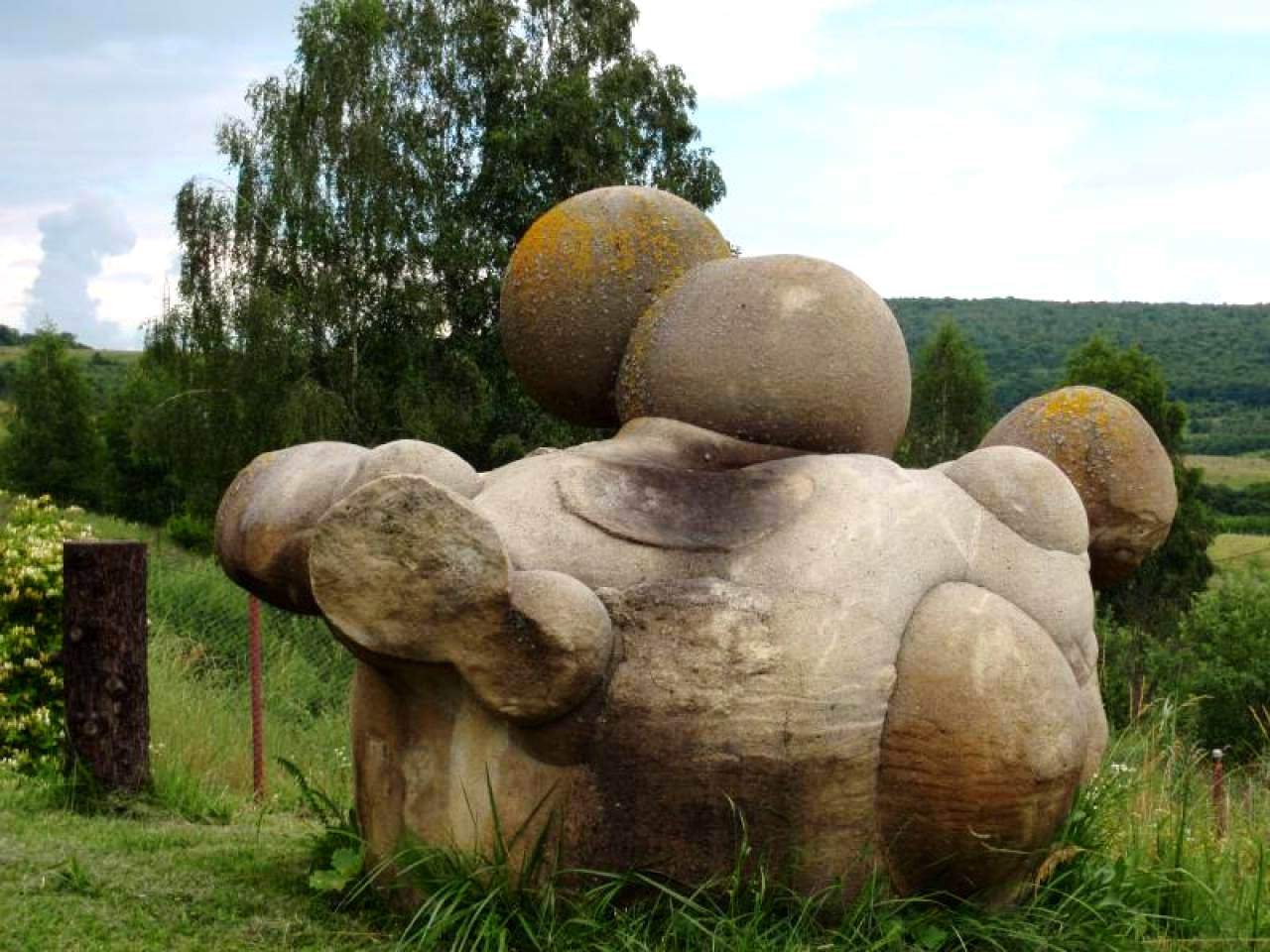
I can't say I'd ever heard of trovants before today, and they seem to be surrounded by weaselly-worded and indirect ("some say ...") claims that at least seem bunklike.
StartPage search results for just the word trovant (so the line below the URL is the page title as scraped by the search engine)
https://science.howstuffworks.com/environmental/earth/geology/trovants.htm
Trovants Are Stones That Seem to Grow, Move and Reproduce
https://whenonearth.net/trovants-growing-stones-romania/
Trovants - The Mysterious Growing Stones of Romania
https://wonderopolis.org/wonder/Are-Trovants-Alive
Are Trovants Alive? - Wonderopolis
https://indie88.com/trovants-are-the-mysterious-living-stones-of-romania/
Trovants Are The Mysterious 'Living' Stones Of Romania - Indie88
https://www.sciencealert.com/these-strange-bulging-geological-manifestations-loom-over-romania
These Eerie 'Living Stones' in Romania Are Fantastical, And Totally ...
https://www.geologyin.com/2018/04/the-mysterious-living-stones-of-romania.html
The Mysterious Living Stones of Romania: They Grow and Move
... and many more.
Drilling down:
The "growing" claim seems to be little more than "once exposed to the elements, over a time-span of centuries to millennia, some of the inner minerals can expand and leach out to the surface forming bumps", with no evidence that this process continues.
The "multiplying/reproducing" claim seems to be little more than a photo that to me looks like several have grown together like overlapping crystals, which is being interpreted as one growing out of another.
 (ibid.)
The "moving" claim could easily be explained by Romania being geologically active.
The page I've quoted seems the sanest of the ones that I've seen, but it still carries the implications that seem like bunk to me - where do they get their silicon from, when they "grow"? That doesn't come from the rain.
This guy makes a claim that a small nugget he holds in his hand will grow into something human-sized:
Source: https://www.youtube.com/watch?v=InwT_7kvO1A
Visiting The Growing Stones | Trovants - YouTube
None of the claims are accompanied by any before/after evidence. It seems as if they're so slowly changing that such evidence doesn't even exist. Everything seems to just be interpretation and extrapolation. Sure, they're an interesting curiosity, but I think they're also a bunk-magnet. Can any geologists shed any light on the matter?
Sorry it this appears a hastily-formed post - I've just been summoned to lunch, and my browser has an annoying habit of losing work in progress, so I thought it's better to post half a thread-starter than have to do over.
StartPage search results for just the word trovant (so the line below the URL is the page title as scraped by the search engine)
https://science.howstuffworks.com/environmental/earth/geology/trovants.htm
Trovants Are Stones That Seem to Grow, Move and Reproduce
https://whenonearth.net/trovants-growing-stones-romania/
Trovants - The Mysterious Growing Stones of Romania
https://wonderopolis.org/wonder/Are-Trovants-Alive
Are Trovants Alive? - Wonderopolis
https://indie88.com/trovants-are-the-mysterious-living-stones-of-romania/
Trovants Are The Mysterious 'Living' Stones Of Romania - Indie88
https://www.sciencealert.com/these-strange-bulging-geological-manifestations-loom-over-romania
These Eerie 'Living Stones' in Romania Are Fantastical, And Totally ...
https://www.geologyin.com/2018/04/the-mysterious-living-stones-of-romania.html
The Mysterious Living Stones of Romania: They Grow and Move
... and many more.
Drilling down:
The "growing" claim seems to be little more than "once exposed to the elements, over a time-span of centuries to millennia, some of the inner minerals can expand and leach out to the surface forming bumps", with no evidence that this process continues.
-- https://www.geologyin.com/2018/04/the-mysterious-living-stones-of-romania.htmlExternal Quote:... after a heavy rain small forms are said to appear on the rocks leading them to be dubbed the "growing stones" by locals.
... can appear to grow at times, as if they are alive.
... after a heavy rain small stone forms are said to appear on the rocks leading them to be dubbed as the "growing stones".
The "multiplying/reproducing" claim seems to be little more than a photo that to me looks like several have grown together like overlapping crystals, which is being interpreted as one growing out of another.
The "moving" claim could easily be explained by Romania being geologically active.
-- https://www.worlddata.info/europe/romania/earthquakes.phpExternal Quote:Recent earthquakes and their magnitudes in Romania - Worlddata.info
In Romania, there are partly large earthquakes with strengths of more than 7.0
The page I've quoted seems the sanest of the ones that I've seen, but it still carries the implications that seem like bunk to me - where do they get their silicon from, when they "grow"? That doesn't come from the rain.
This guy makes a claim that a small nugget he holds in his hand will grow into something human-sized:
Source: https://www.youtube.com/watch?v=InwT_7kvO1A
Visiting The Growing Stones | Trovants - YouTube
None of the claims are accompanied by any before/after evidence. It seems as if they're so slowly changing that such evidence doesn't even exist. Everything seems to just be interpretation and extrapolation. Sure, they're an interesting curiosity, but I think they're also a bunk-magnet. Can any geologists shed any light on the matter?
Sorry it this appears a hastily-formed post - I've just been summoned to lunch, and my browser has an annoying habit of losing work in progress, so I thought it's better to post half a thread-starter than have to do over.