Some Refinements to the Gimbal Sim

About the date for the event, I attach a csv file that lists occurrences of wind > 110 knots at 400 hPa (near 25,000ft), between January 1 and January 25 2015, inside a 300-mile circle from Jacksonville, also excluding day time (between 7am and 3pm local).

Apart from the evening/night of January 24, the closest date would be the night of January 7. Unless they waited 2 weeks to extract the Gimbal video, exactly the night of another high-wind event, this must be it.

I also share the ERA5 data file (Netcdf format) that includes hourly 'u' and 'v' (zonal and meridional components of wind, m/s), 'ws' (wind speed, in knots), and 'height', corresponding altitude in feet (plus 'z', geopotential height, but don't needed here), at different pressure levels. So anyone can check.
Link to ERA5 data for Jan2015
 

Attachments

Last edited:
I've banned Zaine. His posts were getting increasingly incomprehensible, and he's admitted to relying on AI for his analysis, which is probably why.

If he wishes to contribute to the discussion, I suggest he finds someone willing to put in the time to follow what he is saying and check it. So far, it seems to have been a giant waste of time for everyone involved. Perhaps he can team up with @TheCholla or Marik.
 
Incomprehensible to you.

Zaine has proposed an explanation for the clouds misalignment, for which you have none (or a hypothetical additional dero that doesn't hold water). There has been a lot of interesting points in the discussion, but you prefer to shut it off suddenly.

I personally think the distant plane for Gimbal is wrong and has been a giant waste of time too, doesn't mean I can't discuss it.

And how do you know he has used AI only? For which points he made? Horizons mismatch is not from AI, his panorama isn't from AI...
 
Last edited:
I've looked in depth at several points he's raised over the years, and they are all complex theories built upon misunderstandings. I feel like it's wasting everyone's time.

This thread, and the forum, remains open to you and others to make more focused and well-grounded points, which can include continuations of Zaine's arguments, if you can communicate their validity.
 
they are all complex theories built upon misunderstandings
The theory that cloud motion is at an angle because of depression in the elevation angle of the camera, it is not complex, and it is not a misunderstanding.

You simply don't like it because it's inconvenient to your debunk. Or not so inconvenient in fact because the plane can do anything. So what's the matter? I don't see these complex theories based on misunderstandings by Zaine. He doesn't always explain himself very clearly (we all don't) but that's not some obscure theories out of nowhere.
 
The theory that cloud motion is at an angle because of depression in the elevation angle of the camera, it is not complex, and it is not a misunderstanding.
It's something I'm planning on getting around to investigating. But, as I've said, I'm not entirely interested in this, and have other things to do.

Maybe Zaine will be spurred to do a full 3D recreation.
 
Can @logicbear (lbf) demonstrate, what in the gimbal video indicates that there is a secondary rotation device employed?

Put another way, how is @logicbear able to differentiate between

1. Natural background motion due to pod elevation change
2. A second derotation mechanism is being employed?

What are the characteristics that folks should take particular note of?

And as a follow up, how did you determine that there is/ is likely/ is possibly calibration issues with the FLIR 1 footage?

Marik commented this,


Source: https://x.com/lbf_tweet/status/2038842006370185267

you replied with that.

What justification is being used to blanket exclude any claims made about FLIR 1, noting, Underwood, has made representations that the footage is an accurate representation of their experience.

[edit - tor doesn't like uploading screenshots, removed screenshot, inserted relevant tweets]
 
Last edited:
@logicbear @Mick West @Mendel

Can I trouble any of you for a response to the above post?

Heres why, *if* i were to say, theres a third derotation mechanism in use for Go-Fast, something like,

I decided to imagine what a pilot would want to see on their screen, as pilots are more used to driving a car than a plane. Cars typically have outside objects, like trees, street signs etc, pass through horizontally, so it wouldn't be too much to have a resolver account for this, by adding an additional rotation mechanism. The three mechanisms are;

1. the dero mirror
2. LBFs formula
3. Plus an additional amount of rotation to make the water pass through level

The elevation figures aren't able to be trusted as we "don't have a calibrated model of the sensor, the chain of artifacts that led to the video, or a full accounting of the signature of every potential flying thing. So, regardless of what questions you might raise, no extraordinary claims [or claims that the values are actually representative] can be made based on this video."


That would apparently appear to fly/ be justifiable on Metabunk.

So pretty please,

What in the Gimbal video indicates that there is an additional rotation mechanism in use (Strongly noting it failed when tested on Go-Fast).
 
The camera is tracking and focussing on the subject as the subject is stationary and the platform is moving in the straight line, ie not an arc, the platform will get closer to the subject and this will be reflected in the view of the background.
 
Last edited:
The Gimbal ATFLIR footage spans 34.4 seconds. Over that interval the pod azimuth sweeps from 54° left of boresight to 7° right of boresight, a change of 61°. The aircraft is in a sustained left bank; integrating the bank angle over the clip gives a heading change of approximately 66.4°.

The difference is the net sky coverage:

Degrees of sky surveyed = Degrees of motion the pod moves through - Degrees of heading change plane experiences.

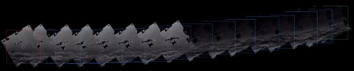
Feature tracking of the cloud structure across the stitched panorama yields a cumulative horizontal displacement of 3.4°. That is 63% of the total sky sweep. The residual,

5.4°−3.4°=2.0°
is the motion of the clouds relative to the "fixed" background.

With a maximum reported wind of 127 knots, a feature moving at that speed for 34.4 seconds travels 1.2 nm. At a range of 35 nm, 2.0° of angular motion produces 1.2 nm of transverse displacement, consistent with a cloud layer advecting at the reported wind speed. Beyond 35 nm the required cloud velocity exceeds 127 knots. Clouds at 120 nm away, the required velocity is 440 knots for them to cover the 2 degrees identified.

This also explains the 20–25% narrowing observed in Mick West's Sitrec reconstruction: the reconstruction was fitted to the 3.4° of tracked cloud motion (match clouds) rather than the 5.4° of actual sky coverage, (use plane bank and speed) compressing the geometry.

Put simply, the clouds can not be more than 40nm away from the F-18/ camera
[edited to tidy it up]
 
Last edited:
The Gimbal ATFLIR footage spans 34.4 seconds. Over that interval the pod azimuth sweeps from 54° left of boresight to 7° right of boresight, a change of 61°. The aircraft is in a sustained left bank; integrating the bank angle over the clip gives a heading change of approximately 66.4°.
If those angles aren't in the same axis, you can't sum them like that, and what you've described doesn't sound like the same axis, quite the opposite.
 
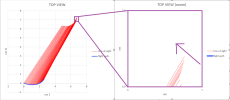
The plot shows the absolute lines of sight from the aircraft across the clip (pod from boresight through to 7R). They sweep leftward and their intercept lies behind the aircraft's final position. The lines are not clustered on a single distant point or a narrow FOV.

Screenshot (8648) - Copy.png

The same leftward motion appears in the final segment of both the Sitrec reconstruction and my reconstruction, when the cloud field is held stationary.

Via Sitrec - Plane bank and speed (not "match clouds")


Via my 3D reconstruction


At the reported maximum wind that residual is consistent with a cloud layer at ~35 nm or closer. Beyond that the required transverse speed exceeds the reported wind.

panorama_full_borders - Copy.jpg

I respectfully re-submit, that there is a delta between the observed panoramas, that has a horizontal degree value of 3.4 degrees, and the degrees of sky that are actually surveyed (Pod degrees of change - degrees of plane heading change).

To resolve this, the clouds are required to move, and as stated, given the maximum wind for that night, the mathematically constrained result is the clouds can not be further than 40NM away, given the values.
 
Back
Top