sirtwentythree
Member
Last edited by a moderator:


Agree. There is about 47 ft hidden. The question should be: How is that possible on a flat Earth?Also if you look at the last image you can see that there is a lot of looming which suggests that refraction is higher than normal. Look especially at the right end of the bridge here.
With all the numbers I've read here. I'm still seeing that under no circumstances whatsoever should we still be able to see 90-95% of a 220ft gap at 17 miles away.
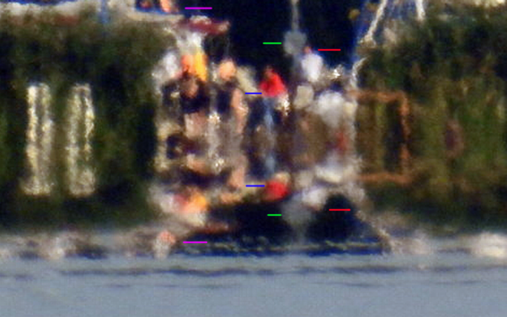
The air. It's a total internal reflection, like a mirage on a hot road.What is what's below the red line reflecting off of?
columns are tough because they generally look the same all the way down. These columns are on a pedestal of sorts but it think FEers would just explain not seeing it as 'waves blocking the view'. A big boat traveling under the bridge would help more.So one would have to be able to zoom in far enough to prove they are actually seeing further down the base of one of those columns for this to have any merit? That can easily be tried.

So one would have to be able to zoom in far enough to prove they are actually seeing further down the base of one of those columns for this to have any merit? That can easily be tried.
A bit like this picture I took a few years ago. There are several reflections with different ships (roughly indicated by the added lines) yet the columns appear to be unaffected.columns are tough because they generally look the same all the way down. These columns are on a pedestal of sorts but it think FEers would just explain not seeing it as 'waves blocking the view'. A big boat traveling under the bridge would help more.
But it really is affected. In the next picture I pasted the same column (but now complete from a different standpoint) and you can see that the lower part of the column is reflected so it appears to be longer than it actually is.A bit like this picture I took a few years ago. There are several reflections with different ships (roughly indicated by the added lines) yet the columns appear to be unaffected.
And finding out exactly when a vessel is passing under the bridge, and detail of the vessel are easy to findcolumns are tough because they generally look the same all the way down. These columns are on a pedestal of sorts but it think FEers would just explain not seeing it as 'waves blocking the view'. A big boat traveling under the bridge would help more.
View attachment 26663
I understand that it might be difficult if the column was completely vertically symmetrical. A very simple way around columns being "tough" is to just put markers on them going down, unique markers to do away with any symmetry, correct?columns are tough because they generally look the same all the way down. These columns are on a pedestal of sorts but it think FEers would just explain not seeing it as 'waves blocking the view'. A big boat traveling under the bridge would help more.
View attachment 26663
I was thinking a vessel passing under the bridge would help clear things up.And finding out exactly when a vessel is passing under the bridge, and detail of the vessel are easy to find
https://www.vesselfinder.com/?lat=37.82376&lon=-122.45464&zoom=12
I understand that it might be difficult if the column was completely vertically symmetrical. A very simple way around columns being "tough" is to just put markers on them going down, unique markers to do away with any symmetry, correct?
")
Really they need to try try it at different times of day, preferably when it's cool. The problem is the heat mirage is obscuring the actual physical horizon.
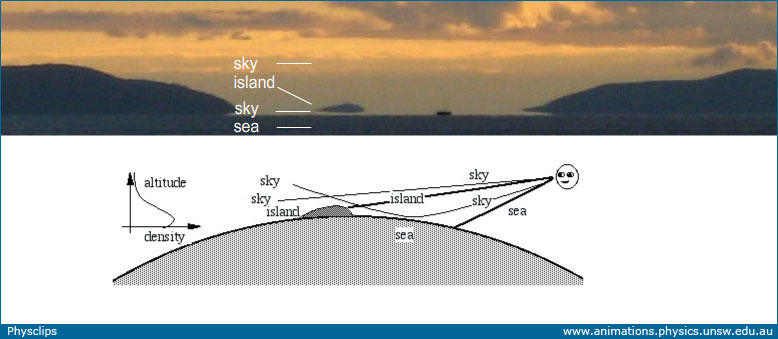
concentrate on the mountain, not the coloumns. the sky is visible under the mountain which is impossible unless its a mirage.To me the problem appears more to be it's not zoomed in far enough to prove that it's a mirage or not.
it's cooler in the mornings. heat hasn't built up. I think Mick is saying that if you take pics in morning and then midday (if its hot) you can see for yourself the difference in refractions/reflections.I think the time of day would be irrelevant, given there's enough light.
This guy did it with a tower in Malmoe that has clear markings
I got it. More or less refraction depending on the temperature. This is not taking into account that we're still not zoomed in close enough to truly tell though, right?it's cooler in the mornings. heat hasn't built up. I think Mick is saying that if you take pics in morning and then midday (if its hot) you can see for yourself the difference in refractions/reflections.
hhmm. its a mountain.I do see that, but there's nothing to tell me that that is truly a reflection. We just gotta zoom in more to figure this one out.
This guy did it with a tower in Malmoe that has clear markings
lets not go off topic. the alleged 'lean back' has been discussed in other threads.The tip of the tower doesn't appear to be angling back as it should the further and further we view it from.
The heights are in the description. 1.5m and also 16m at the last oneHe's failed to take into account the height of the camera lens, right?
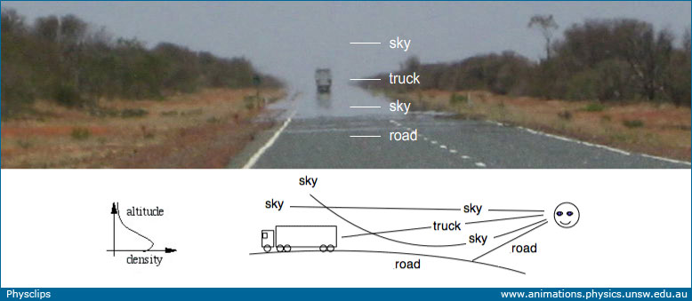
External Quote:A commonly seen mirage is 'water on the road'. The density of air in the atmosphere often decreases monotonically with increasing altitude, due to its weight: the air above compresses the air below. Above a very hot road, however, there is often a layer of warm air whose density is lower than that of the less warm air above. The denser air slows light very slightly more than the less dense, so it has a slightly higher refractive index, so light can bend from the warm air into the cool: light travelling roughly parallel to the road is curved slightly, concave up. This allows the rays, one of which is sketched above, that come from the sky, pass close to the road, then bend back upwards to the eye of the observer. Because one sees sky where the road should be, we often interpret this as a reflection caused by water on the road. The 'water' magically evaporates as we approach.
http://www.animations.physics.unsw.edu.au/jw/light/mirages-green-flash-sky-colours.htm

The heights are in the description. 1.5m and also 16m at the last one
What calculations? There isn't any calculations needed, only location and distance.But he's not taking it into account in his calculations. His calculations assume the camera is at ZERO FEET above the water.
What calculations? There isn't any calculations needed, only location and distance.
The visual effect of the tower being behind the horizon is so obvious, you don't need to calculate anything. But if you think it's bogus, why don't you show exactly where he's wrong? Show the calculations and the error and explain what it means to what we see
Edit: also, observer height is in his calculations https://flic.kr/p/EseKVJ
But he's not taking it into account in his calculations. His calculations assume the camera is at ZERO FEET above the water.
This is important to take into account. 7-8 feet is a global average. Some places have very sallow tides, eg The Black Sea, where the tidal range can be as little as 1-2 feet, or the Seven estuary / Bristol Channel in the UK where the tidal range can up to 50 feetAnother variable is the changing tide - the water line can vary about 7-8 feet/day.