• MH370 speculation has become excessive recently. Metabunk is not a forum for creating theories by speculation. It's a forum for examining claims, and seeing if they hold up. Please respect this and keep threads on-topic. There are many other forums where speculation is welcome.

MH370: Report of Jet flying over Maldives Island Kudahuvadhoo

Status
Not open for further replies.

WeedWhacker

Senior Member
I see. If the plane maintained an altitude of ~5000 feet and bearing that took it over sultan ismail petra airport and the small island the military radar picked it up in the strait it would have struck the mountains on the northern part of Aceh. Those mountains peak between 5000 and 9000 feet.

Or was the plane taken to central Africa?

http://metro.co.uk/2014/03/18/fligh...malaysia-airlines-planes-description-4640688/

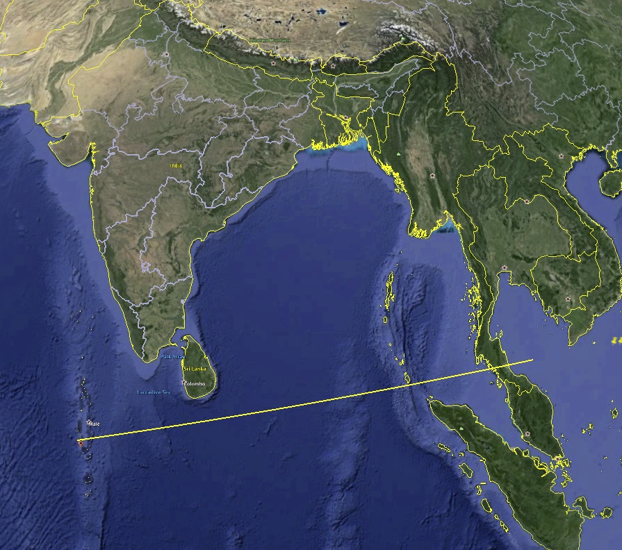
Well this, if confirmed, is certainly another twist. According to the residents in Kudahuvadhoo the low-flying large airline they saw was traveling from the North, and headed South Easterly.

Roughly 0615 local time (so, lighting conditions match for a visual sighting). Interesting. But, that location is quite some distance from the last verified position of MH370. Curious.
 
It's not clear why this report has taken so long to come out:

http://www.haveeru.com.mv/news/54067


Maldives police on Tuesday announced an investigation into reports that residents of the remote Maldives island of Kuda Huvadhoo in Dhaal Atoll have seen a "low flying jumbo jet" on the morning of the disappearance of the Malaysia Airlines flight MH370.

But the police did not reveal any details.

Whilst the disappearance of the Boeing 777 jet, carrying 239 passengers has left the whole world in bewilderment, several residents of Kuda Huvadhoo toldHaveeru on Tuesday that they saw a "low flying jumbo jet" at around 6:15am on March 8.

They said that it was a white aircraft, with red stripes across it – which is what the Malaysia Airlines flights typically look like.

Eyewitnesses from the Kuda Huvadhoo concurred that the aeroplane was travelling North to South-East, towards the Southern tip of the Maldives – Addu. They also noted the incredibly loud noise that the flight made when it flew over the island.

A local aviation expert told Haveeru that it is "likely" for MH370 to have flown over the Maldives. The possibility of any aircraft flying over the island at the reported time is extremely low, the expert added.

The Malaysia airlines jet disappeared on March 8 with 239 people on board after taking off from Kuala Lumpur bound for Beijing. Investigators say it was deliberately diverted off course.
Content from External Source


The Maldives is a very popular tourist destination, so actually gets a lot of traffic - mostly arrivals and departures, and very low small island hoppers. . The island of Kudahuvadhoo is about 100 miles south of the main airport on Male, and would rarely see overflights - expect maybe some Bangkok to Pretoria flights.
 
Maldives is UTC +5, so 6:15 AM Malaysia time is 01:15 UTC Feb 8
Malaysia is UTC +8, so that's 9:15AM Malaysia time. Nine hours after the plane took off?
 
Here's another press report from the same website with a little more detail: http://www.haveeru.com.mv/news/54062

Eyewitnesses from the Kuda Huvadhoo concurred that the aeroplane was travelling North to South-East, towards the Southern tip of the Maldives – Addu. They also noted the incredibly loud noise that the flight made when it flew over the island.
Content from External Source
From the flight path they are describing, southeastward, it doesn't sound likely to be the missing plane. It would have been moving west unless it changed direction north of the sighting.
 
I'm a little confused. Did the plane go off radar at the same time its transponder was turned off, or did one proceed the other?
 
A local aviation expert told Haveeru that it is "likely" for MH370 to have flown over the Maldives. The possibility of any aircraft flying over the island at the reported time is extremely low, the expert added.
Whut? Things are confusing enough without following a statement with an immediate contradiction.
 
If they did see MH370 there at 0615 gmt+5, then Inmarsat's 0811 gmt+8 data must be wrong. It's either one or the other. I say this because Inmarsat's pings place the plane much much more than 1hour from the Maldives.
 
Does anyone know whats come of this "unknown" aircraft that was picked up by radar that was seen flying in the opposite direction around the same time the malaysian flight went off of radar. Correct me if I'm wrong, but can't radar stations determine what type of aircraft it picks up even if it doesn't have a call sign or transponder on. Also if the Thai radar station picked up this "unknown" aircraft couldn't they plot where it came from and where it went, and how is an aircraft "unknown" in this day and age with our technology?

http://www.cnn.com/2014/03/15/world/asia/malaysia-airlines-flight-370-chronology/index.html.
Thai radar picks up unknown aircraft: 1:28 a.m.

The Thai radar station in southern Surathani province picks up an unknown aircraft flying in a direction opposite to what Flight 370 had been traveling, a Royal Thai Air Force spokesman told CNN.
Content from External Source
 
can't radar stations determine what type of aircraft it picks up even if it doesn't have a call sign or transponder on.

No. Without a transponder all you get is a reflected signal - a dot on the radar screen. Similar sized aircraft will look the same.
 
No. Without a transponder all you get is a reflected signal - a dot on the radar screen. Similar sized aircraft will look the same.
But don't military installations have that ability. I thought they did because its not likely your gonna have military jets flying around with transponders on during war time.
 
But don't military installations have that ability. I thought they did because its not likely your gonna have military jets flying around with transponders on during war time.

There are other (military) methods ( think "Star Trek" ;) ).

But here we are discussing civilian aviation transponders.
 
But don't military installations have that ability. I thought they did because its not likely your gonna have military jets flying around with transponders on during war time.
It's pretty much impossible for radar waves to resolve airplanes with enough detail to tell exactly what kind they are. The wavelengths are just too long. Military airplanes do have systems to identify each other, but the details are classified (as far as I know).
 
There are other (military) methods ( think "Star Trek" ;) ).

But here we are discussing civilian aviation transponders.
Sorry, I cited a quote from CNN about the unknown aircraft seen heading in the opposite direction after it's transponder was shut off. I didn't mean to go off topic, and I thought maybe this unknown aircraft could've been important to the investigation
 
Can the MFC store a "flight plan" that can later be recalled or must the pilot enter all the waypoints on every "new" flight? I mean most airlines would be flying between the same destinations, it would be easier if the MFC could "store" flight plans. So the pilot doesn't have to type in all the waypoints on every flight.
 
Can the MFC store a "flight plan" that can later be recalled or must the pilot enter all the waypoints on every "new" flight? I mean most airlines would be flying between the same destinations, it would be easier if the MFC could "store" flight plans. So the pilot doesn't have to type in all the waypoints on every flight.

Well, most current FMCs have capacity for two Routes to be stored. Keep in mind, though, that if only one pilot intends to perform some illegal act (for example), having a flight plan pre-loaded into "RTE 2" is going to be noticed by the other pilot.

You gave me a great idea for a YouTube search (I used the abbreviation "rte") and came up with a bunch of explanatory videos. These are designed to help instruct the many Flight Sim hobbyists, apparently. (And not pertinent, perhaps...and the bloke is a bit confusing, and does it in ways that aren't exactly correct).


The example uses a past version of FMC software (similar to when the first B-737-300s were introduced, in the 1980s) with only one RTE capability. On the CDU in most modern versions when you press the 'RTE' key you are given a choice to cycle between 'RTE 1' or 'RTE 2'.

But, the videos can be a bit informative for the layperson, at least.


ETA:
I mean most airlines would be flying between the same destinations, it would be easier if the MFC could "store" flight plans. So the pilot doesn't have to type in all the waypoints on every flight.

I should clarify that. You are correct. When it comes to airline scheduled routes, in the past there were what we called "canned" routes, and they were printed out, and assigned a shortcut alpha-numeric code. We'd refer to the correct shortcut, and enter that. The computer databases 'knew' these, and would then load and propagate all the various waypoints.

But, starting in the 1990s we began to have a 'DataLink' capability (through the ACARS) so our specific Flight Plan was uplinked and loaded, when requested by the crew. Some long-length flights may have various routing options, depending on weather, winds, and even time of day traffic conflicts. So, what is uplinked is based on what Dispatch has already determined to be THAT plan for that flight. Make sense?
 
Last edited:
Yes , WeedWhacker, that makes sense and tells me just how much has advanced since I was with Transport Canada.
Does ACARS report back data that includes what the FMC is doing? ... is that part of the service that this airline did not subscribe to?
 
Does ACARS report back data that includes what the FMC is doing?

ACARS...primary and most basic function is what we call 'OOOI' times....Out, Off, On, In. For flight-following purposes. It also handled SELCAL when in range of VHF (and nowadays even on HF, but SATCOM is used more also). It's become more advanced, and includes all sorts of possibilities, as subscribed to by the customer (airline). For systems monitoring, faults and such. Can't say that it "spies" on every pilot action or input into the FMC, though.
 
They seem to be dismissing the reports of this.
“The Maldivian National Defense Force (MNDF), in monitoring the areas of the Maldivian territory, is conducting its surveillance efforts with a heightened level of vigilance, in connection to the disappearance of the Malaysian Airline MH370.
“Further to the surveillance conducted thus far, none of the military radars in the country has detected a trace of the missing plane. Furthermore, no trace of the MH370 Airline has been found from the data scrutinized thus far from radars stationed at the airports in the Maldives.
Content from External Source
So what plane was it then?
 
Can't say that it "spies" on every pilot action or input into the FMC, though.
Well if UPS and FedX subscribes to that for their drivers, I can see the same process happening towards pilots for insurance purposes, god forbid there is an accident
 
They seem to be dismissing the reports of this.
“The Maldivian National Defense Force (MNDF), in monitoring the areas of the Maldivian territory, is conducting its surveillance efforts with a heightened level of vigilance, in connection to the disappearance of the Malaysian Airline MH370.
“Further to the surveillance conducted thus far, none of the military radars in the country has detected a trace of the missing plane. Furthermore, no trace of the MH370 Airline has been found from the data scrutinized thus far from radars stationed at the airports in the Maldives.
Content from External Source
So what plane was it then?
Its contradicting right? On one hand they say they've detected a "trace" of the missing plane, but in the same breath they say "no trace" of the missing plane has been found yet.

Just out of curiosity, what if the plane was hit by a surface to air missile by accident, like happened to Iran Flight 655 in 1988. Lets say if the plane shut its transponder off and a military installation in the area recognized it as a FOE, not friend and shot it down. But realized their error afterwards. Would this be something that would easily be discovered, or would an admission be necessary by the military responsible?
 
Well if UPS and FedX subscribes to that for their drivers, I can see the same process happening towards pilots for insurance purposes, god forbid there is an accident

Yes, but that's pretty basic GPS monitoring. I decided to look into it more, to see what's the latest (since i retired), and the Wiki page mentioned this:

In the wake of the crash of Air France Flight 447, there has been discussion about making ACARS an "online-black-box." If such a system were in place, it would avoid the loss of data due to: (1) black-box destruction, and (2) inability to locate the black-box following loss of the aircraft. However, due to high bandwidth requirements, the cost would be excessive and there have in fact been very few incidents where the black boxes were not recoverable.
Content from External Source
http://en.wikipedia.org/wiki/Aircra...ing_System#Flight_management_system_interface

So, it's a matter of 'what' a customer (airline) wishes to have access to on an immediate basis versus the costs. Noting that there is (I think I've mentioned before) something called a QAR (Quick Access Recorder) already, and its data is downloaded by maintenance regularly on the ground, and the info reviewed as part of some airlines' "Continuing Maintenance Program" (a way to save money in their MX Department).
 
ts contradicting right? On one hand they say they've detected a "trace" of the missing plane, but in the same breath they say "no trace" of the missing plane has been found yet.
I think you might be misreading that, they say no trace appeared on Maldives radar. My question as to what plane it was is about the reports of a low-flying extremely loud airliner - that's not something that can be confused with anything else, so unless they were lying, they saw something where it didn't belong. They should at least explain what that was.
 
Yes, but that's pretty basic GPS monitoring. I decided to look into it more, to see what's the latest (since i retired), and the Wiki page mentioned this:

In the wake of the crash of Air France Flight 447, there has been discussion about making ACARS an "online-black-box." If such a system were in place, it would avoid the loss of data due to: (1) black-box destruction, and (2) inability to locate the black-box following loss of the aircraft. However, due to high bandwidth requirements, the cost would be excessive and there have in fact been very few incidents where the black boxes were not recoverable.
Content from External Source
http://en.wikipedia.org/wiki/Aircra...ing_System#Flight_management_system_interface

So, it's a matter of 'what' a customer (airline) wishes to have access to on an immediate basis versus the costs. Noting that there is (I think I've mentioned before) something called a QAR (Quick Access Recorder) already, and its data is downloaded by maintenance regularly on the ground, and the info reviewed as part of some airlines' "Continuing Maintenance Program" (a way to save money in their MX Department).
WeedWhacker, isn't there a GPS locator attached to these black boxes that send out a signal for a month or so. If the black box ends up in the ocean how far down does it have to be to stop transmitting a signal, and would military ships or submarines still be able to hear the signal in the ocean even if it was deep
 
I think you might be misreading that, they say no trace appeared on Maldives radar. My question as to what plane it was is about the reports of a low-flying extremely loud airliner - that's not something that can be confused with anything else, so unless they were lying, they saw something where it didn't belong. They should at least explain what that was.
I agree Peter, Your talking about the witnesses, not the radar blip that came back moments after the plane disappeared off of radar going in the opposite direction...
 
Yes that was Malaysian radar in the general vicinity of the flight path, not Maldive radar which is some distance away below India.
 
Yes that was Malaysian radar in the general vicinity of the flight path, not Maldive radar which is some distance away below India.
A bit OT, didn't know where to put this about the flight and I apologize ahead of time, but it might lend credence to the lack of motivation by Malaysia. The longer they wait the harder the investigation becomes.
http://www.washingtonpost.com/world...112454-ae91-11e3-96dc-d6ea14c099f9_story.html. Does anyone think its a little suspect or just stupidity that Malaysia won't accept the US's help in this investigation. According to reports, the LA FBI office offered their hand in the investigation, and we all know the US has the most experience in piecing these types of situations together, but they still have accepted their help. Many questions are being asked because of this lack of motivation.
 
Well apparently their help doesn't extend to releasing pine gap radar information. I'm sure everyone has their reasons and motivations, everyone wants to hang on to their advantage.

Kuala Lumpur: Malaysia believes data from US spy satellites monitored in Australia could help find missing Malaysia Airlines flight MH370 but the information is being withheld.

The country's Defence Minister Hishammuddin Hussein has specifically asked the US to share information obtained from the Pine Gap base near Alice Springs, according to the government-controlled New Straits Times newspaper.

Authorities in Kuala Lumpur believe that finding the plane now depends on the willingness of a number of countries to share potentially sensitive radar and satellite data.

http://www.smh.com.au/world/missing...-to-release-pine-gap-data-20140319-hvkf2.html
Content from External Source
Well lets home thats the case, because time is of the essence now Peter. Aren't we able to locate the black boxes though, I thought they had a GPS locator fixed to them that sent out a signal for a month or so.
 
Common communications radio waves do not propigate well through water, especially salt water. Submarines communicate while submerged, in the Extremely Low Frequency range which severely limits data rate.
The two flight recorders do, iirc, send an audible ping , a sound, for the purposes of underwater location. No VHF or UHF signal would propigate more than a few feet from a transmitter that is under the ocean.

A modern submarine would have extremely sophisticated listening capabilities and could hear these if it was in range. Now you run into the military secrets issue again. First of all no one likes to give away the area in which their stealthy submarines are operating, and second, no one wants to give any extra hints as to those boat's capabilities.
For instance, if the USA were to state that they had two submarines in the Indian Ocean that heard the ping and the triangulation puts it at a certain location then either these two boats are both close to that location or they both have capability to hear this very well published sound from a long distance.

In the same fashion no one wants to give out that their satellite tracked this aircraft even though it was down at a few thousand feet asl for hundreds of miles.

Sooner or later I suspect, if any super secret tech does have info that can locate the plane, some searching plane or ship will miraculously "discover" that location but how they did it will not include any hint that info came in from that tech. It will "be" due to the hard work and tenacity of the search effort. Its also very plausible that hard work and tenacity of searchers would find wreckage, given long enough.........

I spent time on a military installation that had some top secret tech. I was friends with one of the operators and asked him what he actually did. His answer was " I type". "Type what?" I inquired. No reply. Thinking he did not hear me I asked again. Again no reply, just a blank look in my direction. Message received.
Being a tech I thought I had deduced what an outdoor piece of equipment was for. It was large and visible about ten klicks away. I asked a mi!litary tech about it, to see if I was correct. " Don't know what you mean, there's nothing over there", was the reply to that one even though we were standing in a spot where it was plainly observable.
 
Last edited:
Aren't we able to locate the black boxes though, I thought they had a GPS locator fixed to them that sent out a signal for a month or so.
They are only detectable by sonar within a 25 mile radius (maybe even less), so it's still necessary to find the crash location first. No GPS as far I know.
 
Status
Not open for further replies.
Back
Top