• MH370 speculation has become excessive recently. Metabunk is not a forum for creating theories by speculation. It's a forum for examining claims, and seeing if they hold up. Please respect this and keep threads on-topic. There are many other forums where speculation is welcome.

MH370: Five Indian Ocean Runways found in Captain Zaharie Ahmad Shah’s flight simulator

Mick West

Administrator
Staff member


http://www.bharian.com.my/bharian/articles/5LANDASANDALAMSIMULATORDISIASAT/Article/


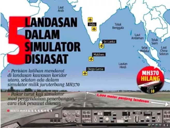
New Delhi: Team investigators found five [runways] around the Indian Ocean in the simulator program Zaharie Captain Ahmad Shah, who was taken from his home in Shah Alam on Saturday.

According to sources, though too early to draw conclusions, taking into account the findings of the investigation as one of the elements of the investigation into the disappearance of the aircraft is driven by Zaharie MH370.

"Some of the [runways] thus far is Male International Airport in Maldives, an airport owned by the United States (Diego Garcia) and three more tracks of India and Sri Lanka, all of which have a distance of 1,000 meters of runway."
Content from External Source
No real details there, but presumably this is something other than the runways just existing in the simulator.

http://www.malaysia-today.net/cops-...al&utm_source=twitter.com&utm_campaign=buffer

(MM) - Investigators have discovered the runways of five airports near the Indian Ocean loaded into Captain Zaharie Ahmad Shah’s home-made flight simulator, a Malay daily reported today.

An unnamed source told Berita Harian that while it was too early to make any conclusions on the new finding, it was still considered an important element in the probe on the whereabouts of the plane and its 239 people.

“The simulation programmes are based on runways at the Male International Airport in Maldives, an airport owned by the United States (Diego Garcia), and three other runways in India and Sri Lanka, all have runway lengths of 1,000 metres.

“We are not discounting the possibility that the plane landed on a runway that might not be heavily monitored, in addition to the theories that the plane landed on sea, in the hills, or in an open space,” the source was quoted as saying.

Although Defence Minister Datuk Seri Hishammuddin Hussein denied yesterday that the plane had landed at US military base Diego Garcia, the source told the daily that this possibility will still be investigated based on the data found in Zaharie’s flight simulator software.

The police had seized the flight simulator from the 53-year-old pilot’s house in Shah Alam on Saturday and reassembled it at the police headquarters where experts are conducting checks.
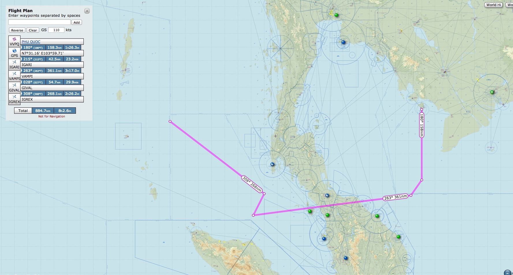
Content from External Source
 
I'm intrigued by these details:


After MH370 disappeared from civilian radar in the early hours of March 8, the plane was flown westward from its intended path to Beijing, turning around at Checkpoint Igari [sic] in the South China Sea.

From there, it flew on to Checkpoint Vampi [sic], northeast of Indonesia’s Aceh province and a navigational point used for planes following route N571 to the Middle East.

Subsequent plots indicate the plane flew towards Checkpoint Gival [sic], south of the Thai island of Phuket, and was last plotted heading northwest towards another checkpoint, Igrex [sic], used for route P628 that would take it over the Andaman Islands and which carriers use to fly towards Europe.
Content from External Source
All of those waypoints would be in the FMC's navigation database. Will need to find appropriate High Enroute Charts to get a better mental picture.
 
IMHO finding simulations of those Indian Ocean runways on the simulator should not ring alarm bells ... at least not yet. I'd be interested to know how frequently he ran those simulations and how recently he ran them. Did he run simulations for other runways around the world regularly? Why did the 5 runways stand out?

LOL i understand I might be stating the obvious ... so pls do moderate & delete if necessary. It'll give me some guidance ;)
 
I'm intrigued by these details:


After MH370 disappeared from civilian radar in the early hours of March 8, the plane was flown westward from its intended path to Beijing, turning around at Checkpoint Igari [sic] in the South China Sea.

From there, it flew on to Checkpoint Vampi [sic], northeast of Indonesia’s Aceh province and a navigational point used for planes following route N571 to the Middle East.

Subsequent plots indicate the plane flew towards Checkpoint Gival [sic], south of the Thai island of Phuket, and was last plotted heading northwest towards another checkpoint, Igrex [sic], used for route P628 that would take it over the Andaman Islands and which carriers use to fly towards Europe.
Content from External Source
All of those waypoints would be in the FMC's navigation database. Will need to find appropriate High Enroute Charts to get a better mental picture.

Interesting insight into the route taken. Why go to waypoint Gival and not directly to Igrex?
 
Interesting insight into the route taken. Why go to waypoint Gival and not directly to Igrex?

I think the article mentioned (...or speculating, the article actually was...) that the airplane flew "towards" GIVAL (we always capitalize aviation waypoints, VORs, etc). In the "SkyVector" image I just took the four waypoints mentioned and the website drew the lines between them. Not meant to represent any actual path of the jet, it was for visual orientation of the region and geography.
 
It looks like we'll have to wait until they figure out what was deleted from the captain's homemade flight simulator. I think it comes down to two options:
1). It's something damning that connects the captain to hijacking the flight, or
2) it's just routine deleting of files and means nothing. Dead end.

Could there be other possibilities?
 
If there was any pre-planning that involved more than just the pilot's whim then there should be some form of communication trail.
If he was planning to put down at another runway then the runway personnel have to be in on it if they meant to hide it, meaning there has to be some kind of organising going on, it would leave a trail.
Nothing like that seems to be coming to light.
 
I don't find t suspicious that those airports were on the simulator. If you look at the Malaysian Airlines route map, there is a strong correlation. It looks like a conscientious pilot practicing arrivals into airports he either uses or could use as an alternate.

image.jpg
 
Thanks WeedWhacker. I see this plane flew often between Kuala Lumpur and Amsterdam. Is it likely that there was a flight plan stored in rte2 for that route? (probably belong in speculations thread)
 
Rte 2 is used for different things by different pilots. It can be changed throughout a flight. On take off a pilot may have an expeditious return to the departure airport programmed there in case of an emergency. Enroute there may be the track to the nearest company alternate or a depressurisation route for when flying over mountainous areas. On arrival there may be different arrivals/runways to cope with ATC instructions.
It is used every flight for contingency planning.
 
Thanks WeedWhacker. I see this plane flew often between Kuala Lumpur and Amsterdam. Is it likely that there was a flight plan stored in rte2 for that route? (probably belong in speculations thread)

All info in the volatile memory (such as any current flight plan info) is dumped whenever power is turned off. Just like any computer.
 
Back
Top