Geolocation Exercises

JFDee

Senior Member.
I'm proposing a thread (or maybe a dedicated subforum) where photos can be posted with the task to geolocate them, for educational and training purposes, and yes. also for fun :cool:

Also possible are variants where e.g. the time of a photo is hidden and must be determined.

As a fairly easy starter, I post the photo below.
What is my exact position here?


geolocation_task.jpg
 
Last edited:
The Reichstag in the center gave it away for me, no web search required.

@JFDee , I don't understand what sets this thread apart from similar existing games.

If this is to be a social activity, then I propose that solutions should come in form of images with no identifying marks, such that a solution entry doesn't give the game away. The exact location could be posted by the OP after a suitable time, e.g. 3 days or a week.

Then, the first person to solve should post the next problem. Or they could pass, in which case the next solver is up, etc.

For example, it would now be @flarkey 's turn to post a picture to geolocate.

P.S.:
• reverse image search etc. should be considered cheating
• for historic photos, the OP should upload a crop; solutions should be the full picture with a watermark.
 
Last edited:
What is my exact position here?


geolocation_task.jpg
Using "Add Photo" tool on Google Earth it may be possible to nail the position of the camera (including altitude) within meters, but doing it manually is rather cumbersome. Here is my unrefined first attempt:
DB Berlin.jpg
 
A slightly trickier one, but. What is the name of the Bridge towards the right hand side of this image.

1710414679655.png
 
I tried to find it but the spirit crushing nature of British retail parks overcame me

I thing to make this a more metabunk thing, we should use/try the various techniques and tools we've accumulated over the years and provide use case examples based on them
 
I tried to find it but the spirit crushing nature of British retail parks overcame me

I thing to make this a more metabunk thing, we should use/try the various techniques and tools we've accumulated over the years and provide use case examples based on them
Indeed. That was my intent.

I think mine can only be found by querying the OpenStreetMap Database, using either https://overpass-turbo.eu/ or https://osm-search.bellingcat.com/

A clue is it is on the Island of Ireland.
 
Last edited:
Ropeworks bridge, BT5 4AF
Screenshot 2024-03-14 at 12.57.02.png
Nice one @Trailspotter - what was your method?

This is how I would have found it using overpass-turbo

https://overpass-turbo.eu/s/1IC7
// Find coastlines in view (bounding box)
[out:json][timeout:200];
nwr[power=line]({{bbox}});
nwr(around:50)["name"~"lidl",i];
nwr(around:50)["name"~"home bargains",i];
// print results
out geom;

Find an electricity pylon, which is within 50m of a Lidl, which is within 50m of a bridge. It returns only 1 result.
1710421725280.png
 
Last edited:
Last edited:
That's what I'm doing, but no luck. There was a close contender in Wales, though.
I failed because I wasn't using nwr. This works:
C-like:
area[name~"Ireland"]->.boundary;
nwr [name~"Halfords"](area.boundary);
nwr(around:200) [name="Lidl"];
nwr(around:200) [bridge=yes];
nwr(around:200) [power=tower];
(._;>;); out;
 
I am assuming just image-searching the posted pic is cheating a bit? :)

This reminds me of GeoGuessr. which I play from time to time. It gives you the advantage of allowing you to turn the "camera" or even to wander around a bit most of the time.

The sufficiently bored are welcomed to play a "map" I created, "Places where I have flown kites." With the start location set as near as possible to where the kites were flown, with a little wiggle room to move away from the big sign that says "Welcome to Passir Gudang, Malaysia" or similar dead giveaways. For a few sites on my map, there is limited coverage and all there is is the one image with no ability to explore, sorry, not my fault, and some of these are stupidly generic in terms of trying to deduce location. But most are not too difficult to at least get reasonably close. And a few even feature visible kites being flown, though so far none of mine show up...

Anyway, if interested, https://www.geoguessr.com/maps/642f1e54940ceb4e94756cae/play
 
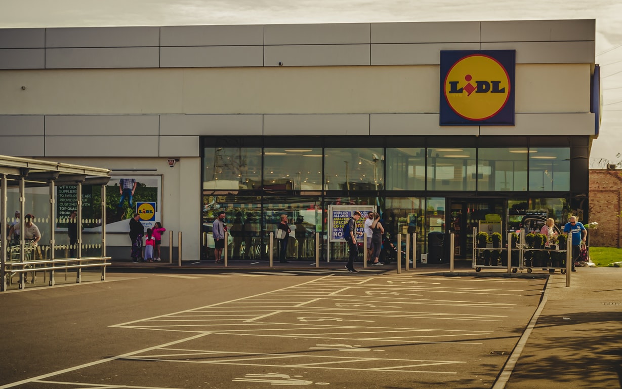
I googled "Lidl Superstore' and scanned the images.
After seeing the clue:

Off to https://labs.perplexity.ai/ :
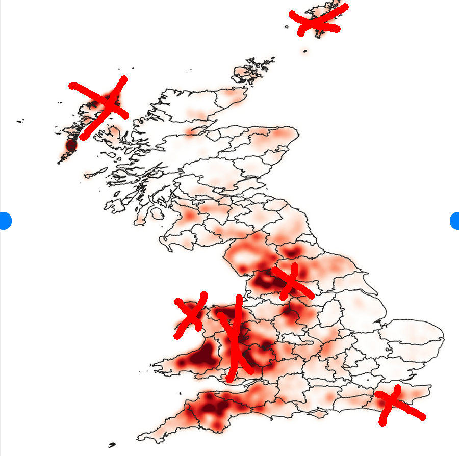
--> Where in Ireland is there a Lidl right near a Halfords?
There is a Lidl store located near a Halfords in Belfast, Northern Ireland. This information comes from a blog post by Northern Ireland Greenways detailing their survey of cycling facilities at 40 chain supermarkets in Belfast, specifically mentioning Lidl's five locations in Belfast. However, the exact address or distance between the two stores is not provided in the search results.

So I threw ``belfast halfords'' into www.startpage.com to get:
Halfords - Connswater Store
Halfords Store Connswater Unit 12, Connswater Retail Park Alberetbridge Road Belfast

Then I pulled up Belfast in openstreetmap.org and searched for ``Connswater Retail Park'' which suggested these important locations relevant to the search:
Retail Area Connswater Retail Park, Sydenham, Belfast, County Down, Northern Ireland, BT5 4AF, United Kingdom
Service Road Connswater Retail Park, Ballymacarret, Belfast, County Down, Northern Ireland, BT5 4AF, United Kingdom
Supermarket Lidl, 3, Connswater Link, Connswater Retail Park, Sydenham, Belfast, County Down, Northern Ireland, BT5 5DL, United Kingdom
Car Parts Halfords, Unit 12, Connswater Link, Connswater Retail Park, Ballymacarret, Belfast, County Down, Northern Ireland, BT5 5DL, United Kingdom
And sure enough there were Lidl and Halfords right next to each other apart from something that needed crossing, Conn's Water, and the Ropeworks footbridge was that crossing.

Each step was about 5 seconds, the clue was way too much of a helper.
 
I am assuming just image-searching the posted pic is cheating a bit? :)

This reminds me of GeoGuessr. which I play from time to time. It gives you the advantage of allowing you to turn the "camera" or even to wander around a bit most of the time.

The sufficiently bored are welcomed to play a "map" I created, "Places where I have flown kites." With the start location set as near as possible to where the kites were flown, with a little wiggle room to move away from the big sign that says "Welcome to Passir Gudang, Malaysia" or similar dead giveaways. For a few sites on my map, there is limited coverage and all there is is the one image with no ability to explore, sorry, not my fault, and some of these are stupidly generic in terms of trying to deduce location. But most are not too difficult to at least get reasonably close. And a few even feature visible kites being flown, though so far none of mine show up...

Anyway, if interested, https://www.geoguessr.com/maps/642f1e54940ceb4e94756cae/play
IMO all methods are valid as long as we get the result, Metabunk investigations are not a contest with rules

I used overpass in this case
https://www.metabunk.org/threads/daytona-ufos-28-may.12458/post-271753
 
I don't understand what sets this thread apart from similar existing games.

I'm not familiar with these, but I thought it would be educational for readers around here.

If this is to be a social activity, then I propose that solutions should come in form of images with no identifying marks, such that a solution entry doesn't give the game away. The exact location could be posted by the OP after a suitable time, e.g. 3 days or a week.

Then, the first person to solve should post the next problem. Or they could pass, in which case the next solver is up, etc.

For example, it would now be @flarkey 's turn to post a picture to geolocate.

P.S.:
• reverse image search etc. should be considered cheating
• for historic photos, the OP should upload a crop; solutions should be the full picture with a watermark.

My example was WAY too easy but it has served quite well as clickbait :)

I like these rules. However, the exhibits should at least be solvable in theory. Also, for educational purposes, the leading solvers should explain their methods after the image poster provides the solution.
 
Late to the party, but I got it without overpass and without the clue.

After a few false starts looking for fancy wooden lamp posts and canal side retail parks I went to the Home Bargains website's store locator (they have fewer outlets than Lidl or Halfords), clicked "list all stores" and worked my way down the list until I found one that matched the picture. The aspect ratio of the signage is quite distinctive so when I got to Connswater Retail Park it was pretty obviously the right one.

Thankfully I only had to go through the list as far a "C." They have about 500 stores so had it been the one in York I might have given up before I found it. That said it took less than 10 minutes once I'd settled on the method.
 
I'm in two minds about image search. If someone is genuinely looking to find an unknown location then it is absolutely a valid method of working out where it is. However in these challenges it does make them a little too easy.
 
Interesting. My image search didn’t give a straight answer. However, the skyscraper on the background is the 20th tallest building in the world.
i was wondering that which is why i checked Google images. I had actually used yandex. lots of similar pics.
Screenshot 2024-03-14 142743.png
 
Interesting. My image search didn’t give a straight answer. However, the skyscraper on the background is the 20th tallest building in the world.
Google Lens knew the city, too (though it thought the photo was taken in a park), but I couldn't work out where the view was. I also tried to identify the distinctive type of railway masts seen in the picture, but failed.
 
Urban areas with iconic buildings are easy. Shopping malls are bit harder as they can all look alike, but once a store is identified it can be cross referenced with the other retailers in the photo.

Let's get random, this is where one could hunt for Bigfoot, but not Patty:

IMG_6008.jpeg

Location in the spoiler to check guesses.
40.01884, -121.44652
 
Urban areas with iconic buildings are easy. Shopping malls are bit harder as they can all look alike, but once a store is identified it can be cross referenced with the other retailers in the photo.

Let's get random, this is where one could hunt for Bigfoot, but not Patty:

However, I'd propose that this rule is observed:

The exhibits should be solvable, at least in theory.
 
However, I'd propose that this rule is observed:

The exhibits should be solvable, at least in theory.
What? All you need to do is find this pond a good distance east of that mountain range, presumably the Rockies. ;)

(My guess would be that it's near a road.)
 
However, I'd propose that this rule is observed:

The exhibits should be solvable, at least in theory.

Agreed. I had to leave right after I posted and figured I would delete it when I got back after I thought about it. It's just a random photo in the woods, but @deirdre PMed me a general area guess and she's right. I can delete or folks can just ignore.

I guess people can always offer up clues.
 
First impressions:
Cemetery surrounded by a stone wall, grave markers of many different shapes, mature trees around the outside of the stone wall, no church in sight. Cemetery has been here for a long time.
Narrow road, with a section that appears to have (or had) well trimmed hedge along the sides. Power poles without crossbars. Rural road, low population neighborhood.
Mature pasture land, been under cultivation for a long time, boundaries follow the lay of the land. Mature windbreaks.
Guess: someplace in England

Agree, classic british rolling hills. Sheep but not in the UK's peak elevations makes it most likely[*] in the dark bits I've not crossed out: I should further the metropoles, but fortunately there aren't many sheep in metropoles, so there's not much worth crossing out.

Can we work out what the walls are - is it some kind of limeshone? Can that be used as an overlay to further filter out regions?
Graveyard without church is going to be the uniquifier, though.

[* assuming this is a photo of a randomly selected sheep. Remember kids, the average town is small, but the average person comes from a large town. (Is there a name for that paradox, or the fallacy of not taking it into consideration)?]
 
Back
Top