Geolocation Exercises

The Dan, Dan, Daaaaan! scene has some very similar countryside with many pylons and the same car, but not many clues as to where it might be. This frame shows a large bridge in the background, which I think could be the Dartford Crossing, or possibly the Orwell Bridge in Suffolk. Any ideas?
I know that the driving scene was in Aveley. The bridge is the Dartford Crossing (Queen Elizabeth Bridge).

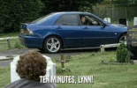
The bit where Lynn throws Sonja's fake beard out of the sunroof at 0:51 in that clip is here on Ship Lane, the repaired brick wall on the left is a good marker: https://maps.app.goo.gl/4Un8fuESJtxCwCo76?g_st=ic

IMG_3665.jpeg


That is only a few yards along the road from your screenshot above: the same bush and telegraph pole is visible in the background.

1740923110000.png


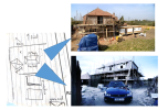
The landscape with all the pylons looks very similar to the house location so I think it must be nearby.

The Choristers location in Surrey is a red herring I think.
 
Last edited:
@Trailblazer - I'm still trying to find this house with no luck.

Using the photo of the house I'm using overpass turbo to find "A pylon X distance from to two power poles that are Y distance apart and Z distance from a building". I think the view is looking North West.

Pretty sure the big pylon is an L2 Type carrying 400kV, but the OSM tag of power=tower should be unique enough and there's no need to use voltage=400000. The smaller poles should have the tag power=pole.

https://www.pylons.org/members/fieldguide.shtml


The 400v Network is well captured in the OpenStreetMap database (white lines) but the minor power lines (green) are less so,

This is the script (https://overpass-turbo.eu/s/1ZJt). I've selected Distance to pylon=800m, distance between power pole = 10m, distance to building 30m.
[out:json][timeout:660];
node["power"="tower"]({{bbox}});
nwr(around:800)["power"="pole"]->.poles;
foreach.poles->.pole {
(nwr.poles(around.pole:10);
-
.pole;
);
nwr(around:30)["building"="yes"];
// print results
out meta geom;

I still agree that this is probably around the Thurrock or Dartford area . When Alan takes Lynn to visit her mum's grave, its at West Thurrock Cemetery. It also shows pylons in the background.


Attachments

  • 1741078097591.png
    1741078097591.png
    456.8 KB · Views: 26
Last edited:
Here's a slightly wider angle.

View attachment 77864

The shape of the house confuses me. The nearest end wall seems to have sloping sides, so is it a kind of mansard roof extending down to the bottom of the upper storey, with dormer windows in it?
And the picture above seems to show the garage on the field side of the house, above the caravan? Then there is maybe an L-shaped bit of house sticking out to the right with the chimney on it?

Which direction are we looking at here? Is the right-hand wall the end we are looking from above, with the chimney behind visible above the left-hand dormer window? In which case the building above the caravan can't be the same garage.

1741089738559.png
 
Also does anyone know what these smaller pylons are?

1741090108591.png


I wondered whether they were some kind of railway infrastructure but couldn't find a match. And it's odd to have two of them so close together.
 
For more old-school pylon peeping, it's worth remembering that Ordnance Survey maps show power lines using this symbol at 1:50,000 scale: the black line with V-shaped ticks along it.

1741100905210.png


The arrows marking pylons don't reflect the actual pylon locations at this scale, but at 1:25,000 the small squares along the dashed line do show the actual pylon locations:
1741100953749.png


I wondered if this might be a clue, but no... :)

1741101029369.png


Link to the target area: https://streetmap.co.uk/map/idld?x=...d&searchp=ids&dn=816&ax=556500&ay=180500&lm=0
 
Here's a slightly wider angle.

View attachment 77864
and it appears to have two neighbouring houses. Note the gable end below.

View attachment 77866
From above I think we're looking for something like this:
View attachment 77869
With a wider view

1741101495573.png


KML of all Pylons and power lines is attached if it helps.
/*
This has been generated by the overpass-turbo wizard.
The original search was:
"(power=tower or power=line)"
*/
[out:json][timeout:25];
// gather results
(
nwr["power"="tower"]({{bbox}});
nwr["power"="line"]({{bbox}});
);
// print results
out geom;
 

Attachments

Last edited:
what about seeing these as opposite shots, instead of the 90⁰ you're suggesting? it would fit the spikes on the roof better, fit the number of uprights in the framework, and fit the gutter lines of the roof.
hmm. you might be right. the angles are melting my brain
 

Attachments

  • 1741103894472.png
    1741103894472.png
    587.8 KB · Views: 22
hmm. you might be right. the angles are melting my brain

Me too. It's like one of those spatial awareness IQ challenges. I couldn't get the rooflines to make sense until I had an epiphany - there are two houses, plus the garage!

This is hopelessly not to scale, but this is how I see it.

The main house, seen in the shot with the car, has three dormer windows on each side and a chimney on the left-hand end of the roof.

In the shot with the field in the background, you can see the corner of one of the dormer windows on the other side of the house, and the chimney, and the angled garage. The circles on the rooflines are the little spire ornaments. If the view across the fields is northwest, then east is at the top in this diagram.

1741109900422.jpeg


This bit here sticking out below the chimney and casting a shadow on the wall is the top left-hand dormer window in my diagram.

1741110102840.png
 
Me too. It's like one of those spatial awareness IQ challenges. I couldn't get the rooflines to make sense until I had an epiphany - there are two houses, plus the garage!

This is hopelessly not to scale, but this is how I see it.
I like your diagram, but I believe the two houses are attached.
 
I like your diagram, but I believe the two houses are attached.
I did wonder that, but I couldn't get the rooflines to work out. Maybe they are attached and there is just one dormer window on that side of the house?

Something like this? It looks like on the left you can see part of that main house but not sure if it is wall or sloping roof.

1741110883627.png


1741110798989.jpeg
 
@Trailblazer 's new drawing makes sense with the angles and the views. Assuming that the shadows are pointing north (they are short, so the time of the photo is close to noon) - then the neighbouring houses & van suggest a road running North/south and then the pylon line is running east-west.

 
I recently geolocated the petrol station in this Alan Partridge video for someone on Reddit. The look of the petrol station has changed significantly since 1997 so reverse image search doesnt work.
I found that thread on Reddit and was surprised to see that it's not the petrol station I thought it was!
I was thinking of the one used in series 2, which is in Sunbury-on-Thames. https://maps.app.goo.gl/t1neKypi99sX7KDg7
 
1741123050956.jpeg

I wonder if you guys can figure where or when this picture was taken. I'll say that it was in 2025, the location might be too tricky so I can give a hint if you can narrow it down or are too far off.
 
And to revisit the challenge from #89 here's a clue.
View attachment 77910
the new, brighter image carries a 2023 Google watermark, so it's presumably a Streetview image, and was taken from a road.

the "UFO" may be a biogas storage tank, in which case the buildings belong to a farm with large stables, possibly containing chickens.

there's an absence of power poles and wind turbines
 
Last edited:
Thanks. Yes, great work on the drawings!

Classic clip of Alan getting a visit on the house/caravan site from the Inland Revenue. Air guitars at the ready!


Source: https://www.youtube.com/watch?v=VokAbAfTfCc

I had wondered if that was filmed on a separate set but it looks like it was there. The caravan was tucked into this L-shaped corner, and the patio door on the right is the one behind the tax inspectress.

1741183773195.png
1741183762053.png


I wonder if the current owners are aware of their home's place in TV history. It last sold in 2006.
 
the new, brighter image carries a 2023 Google watermark, so it's presumably a Streetview image, and was taken from a road.

the "UFO" may be a biogas storage tank, in which case the buildings belong to a farm with large stables, possibly containing chickens.

there's an absence of power poles and wind turbines

https://wiki.openstreetmap.org/wiki/Tag:building=digester
The tag building=digester represents a building specially designed and constructed as a digester, a bioreactor for the production of biogas from biomass.

Quite a few come up in Overpassturbo, haven't found one that matches yet

https://overpass-turbo.eu/s/1ZOq
 
View attachment 77908
I wonder if you guys can figure where or when this picture was taken. I'll say that it was in 2025, the location might be too tricky so I can give a hint if you can narrow it down or are too far off.

1741191126758.png


(Assuming we are in the UK) the green road sign indicates a primary A road, and doesn't seem to be legible at all so that doesn't narrow it down too much. It's a fairly new-looking dual carriageway with a grade-separated junction, and I think there might be a blue patch at the end of the second line of the sign, indicating a motorway route nearby.

The white blob at the bottom right of the sign is a bit puzzling - it's where you'd normally find a junction number on a motorway sign, but primary routes don't (AFAIK) ever have numbered junctions.
 
Last edited:
Hazarding a guess at a WNW view looking from an A road toward a motorway with the green sign indicating a turn of to an A road.
1741123050956.jpeg
 
I had wondered if that was filmed on a separate set but it looks like it was there. The caravan was tucked into this L-shaped corner, and the patio door on the right is the one behind the tax inspectress.

View attachment 77925View attachment 77924

I wonder if the current owners are aware of their home's place in TV history. It last sold in 2006.
There should be a Blue Plaque!

I wonder where the static home is? Someone has been trying to identify it.

https://www.caravantalk.co.uk/community/topic/128692-alan-partridge-static-home-model-id-help/
 
And to revisit the challenge from #89 here's a clue.
View attachment 77910
Because I know what a massive time suck these things are here's one method to solve this one.
@Mendel guessed correctly the "UFO" is the top of anaerobic digester. However, it doesn't appear in both photos which means it's relatively new (the Google maps image is from 2023 and I took the sunset photo in Dec '24—but, you'd have to have guessed that). It also does not appear on either Google Maps or Apple Maps satellite imagery. Because of its newness it's not been tagged in OSM (yet). So can't be used to locate this farm using Overpass Turbo or other tag searching method. So it's a bit of a red herring....

1741214832882.png


However, there are enough old and tagged things in the photo to get to the right answer, if we guess some general things, like that it's somewhere in England and the photos are taken from a road.

Specifically a trunk road: highway=trunk
We can see some general buildings, that look like a farm yard: landuse=farmyard
On the left are some trees: natural=wood
and spanning the field is a wall. Specifically a dry stone wall: barrier=wall AND wall=dry_stone

If you search for these elements within an estimate radius of 150m from each other then you should get around 52 hits, which is still quite a lot, but few enough to be able to review the streetview imagery for in order to match the photos. (the correct hit for me was #44).

From Bing Streetside:
Screenshot 2025-03-05 at 23.20.54.png


*** Bonus points on offer for pinpointing when the digester was installed.***
 
Back
Top