Does the Earth's Curvature Vary with Latitude? [No, not significantly]

Rory

Closed Account
Just wondering if we should be factoring in latitude with the earth curvature calculator? For example, if Chicago is at 41.9 degrees, then doesn't that make the earth's E/W circumference 18,581 miles and its radius 2957 miles?

I'm probably wrong but, if not, then using the Nowicki photograph, for example - 53 miles distance, 230 feet elevation - that gives 16.05 miles to the horizon rather than 18.57 miles, and - I think - an obscured amount of 1223 feet rather than 793 feet.

That seems quite a big difference. Can somebody check please?

Cheers.
 
Last edited by a moderator:
Finally, just wondering if we should be factoring in latitude with the earth curvature calculator? For example, if Chicago is at 41.9 degrees, then doesn't that make the earth's E/W circumference 18,581 miles and its radius 2957 miles?

I'm probably wrong but, if not, then using the Nowicki photograph, for example - 53 miles distance, 230 feet elevation - that gives 16.05 miles to the horizon rather than 18.57 miles, and - I think - an obscured amount of 1223 feet rather than 793 feet.

That seems quite a big difference. Can somebody check please?

Cheers.

And no, we should not be factoring in the latitude. You need the radius of the sphere that you are on. The radius of the parallel (longitude circle) is irrelevant. The geographic coördinate system is a result of earth's rotation (with poles and equator, etc.). But the curvature would be the same if the sphere were not rotating at all, independent of the direction, always measured along a great circle.
 
Last edited by a moderator:
I've seen this confusion popping up lately and I can see why - lines of latitude get smaller toward the poles, so the curvature must be less.

But you are not looking along a line of latitude.

To keep this as non-technical as possible:

From your vantage point on the surface of the earth, a line of latitude curves side to side. A great circle curves up and down... and thus follows the curvature of the earth. You can't look along either one of them, because light doesn't curve. But the great circle is straight side to side. So your line of sight remains directly above the great circle... it doesn't stray side to side. But the line of latitude would curve away, right or left, from beneath your line of sight.

It's best to use a string on a globe to understand what I'm saying.
 
Last edited:
It's an interesting question, as it presents challenges of explaining the "no" answer clearly. I understand exactly why the answer is no, but I'm having a lot of trouble understanding Z. W. Wolf's explanation, above, so I expect other people would too.

It's difficult because people have different understanding of concepts like "curvature" and "radius". My natural inclination to explain it is to ask people to essentially consider the arc of the circle on the surface of the Earth that's formed by the intersection of the Earth and the plane defined by three points: the view point, the target point, and the center of the earth. I'd ask them to consider how this is a "great circle", and how other circles are "small circles", because the plane they form does not pass through the center of the earth.

This all makes perfect sense to me, but I suspect to many people it makes as little sense as the other explanation.

I think ultimately it's something of a lost cause attempting to verbally explain such things. Diagrams and videos are really needed, but seem like they take more time to do.
 
Last edited:
Yes, the Earth curvature does change with the latitude, but not for the reasons you wrote. Other posters above explained why you were wrong in that sense. However, the Earth is not a perfect sphere, it is slightly flattened at the poles. It means the curvature is indeed different at poles than on the equator. The difference is rather negligible though - according to NASA, the polar radius is 6,356,752 m and the equatorial radius is 6,378,137 m (Wiki claims a bit different values).

EDIT: The calculation would be a more complicated than I originally posted, so I removed it. Also, except of the poles, the horizon distance is not perfectly isotropic (it very slightly differs in longitudinal and latitudinal directions). The difference is around a tenth of a percent.

Of course, there are other effects that play a role - namely the refraction, but also waves or tide. You can read a very detailed information about horizon at WikiPedia. An the curvature of the Earth is described there too in this article: https://en.wikipedia.org/wiki/Figure_of_the_Earth
 
Last edited:
However, the Earth is not a perfect sphere, it is slightly flattened at the poles. It means the curvature is indeed different at poles than on the equator.

There's also a variation in average water surface heights due to both the uneven gravitational field of the earth, and ocean currents and winds, again though it's negligible for most "flat earth" related discussions.

Here it's greatly exaggerated:

http://www.seos-project.eu/modules/oceancurrents/oceancurrents-c06-s03-p01.html

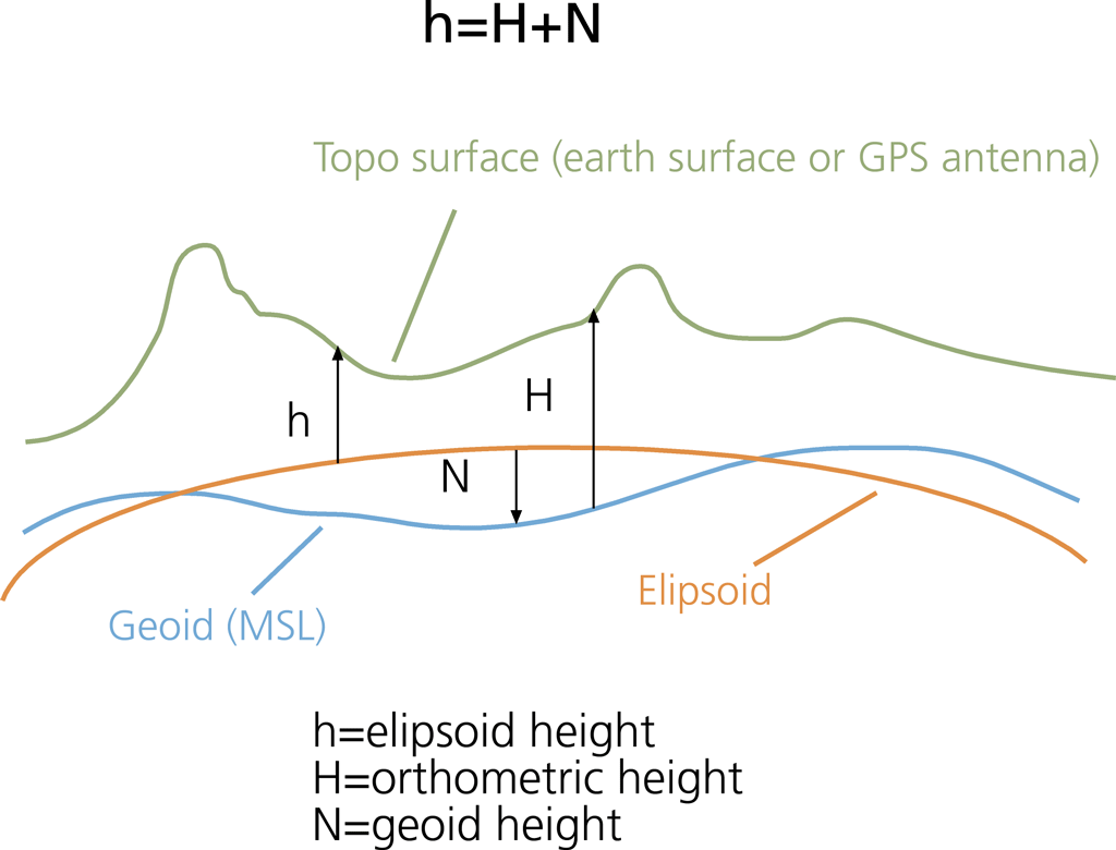
Even if there were no currents, the sea surface would still be rather bumpy, with variations of ±100 m (over very long distances, of the order of thousands of kms) compared with a smooth ellipsoidal shape, because gravity varies from place to place: where it is stronger it will pull more water and there will be a bump, where it is lower there will be a trough. The no-motion surface that the sea would assume in absence of currents is called the geoid.
Content from External Source
 
It's an interesting question, as it presents challenges of explaining the "no" answer clearly. I understand exactly why the answer is no, but I'm having a lot of trouble understanding Z. W. Wolf's explanation, above, so I expect other people would too.

It's difficult because people have different understanding of concepts like "curvature" and "radius". My natural inclination to explain it is to ask people to essentially consider the arc of the circle on the surface of the Earth that's formed by the intersection of the Earth and the plane defined by three points: the view point, the target point, and the center of the earth. I'd ask them to consider how this is a "great circle", and how other circles are "small circles", because the plane they form does not pass through the center of the earth.

This all makes perfect sense to me, but I suspect to many people it makes as little sense as the other explanation.

I think ultimately it's something of a lost cause attempting to verbally explain such things. Diagrams and videos are really needed, but seem like they take more time to do.

I was a attempting a purely intuitive explanation. I don't know how successfully. I wasn't satisfied myself. But trying to use intuitive terms like up and down and side to side.

Yes, these verbal explanations are inherently inadequate. Which is one reason why YT comments sections are so frustrating.

What I've found is that skeptics and FE'ers have an entirely different mental language. Your explanation is entirely analytical and seems second nature to you. Flat earthers have an almost entirely intuitive mental language. You'll often find skeptics and flat earthers completely baffled and frustrated by each other. Flat earthers are often convinced that the analytical explanations offered to them are nonsense and they get angry about it.

Ordinary folk can be analytical but often respond to intuitive explanations more readily; especially if the analytical argument is based in something like math that only makes sense if you've studied math.
 
Last edited:
Ordinary folk can be analytical but often respond to intuitive explanations more readily; especially if the analytical argument is based in something like math that only makes sense if you've studied math.

Yes, and I think it's important to remember that flat earthers are just "ordinary folk" and in many cases not significantly different in their understanding of geometry than any number of people. Perhaps though they are different in their estimation of their understanding. Real "ordinary folk" don't understand the geometry, and they don't think they do, so they trust people who do.

And of course you get people like that in the flat earth community, they just trust a different set of authorities.

I think though that there are sufficiently comprehensible explanations of the fact that the earth is spherical, and that really the majority of people should be able to figure it out without authority. Minor brain teasers like this are probably best avoided as they are not really relevant (unless they actually want to argue that the earth is a cylinder.)
 
Well, I'm glad to hear that it's an interesting question, if one wrong in its assumptions. Intuitively, it does feel that the latitude of two points on a sphere wouldn't make a difference, and when it's explained like this:
Imagine if the earth were a featureless sphere. Pick any two points on the surface of the sphere. The only factor is the distance between the points.

Or think of it another way: picture the center of the earth. Now think about the angle formed by the two points and the center of the earth. The distance from the center to any point on the surface is the radius of the Earth, regardless of latitude.

that makes sense too - and yet my head still has questions, which I may as well post since answering them will no doubt help in any future FE discussions I find myself daft enough to get involved in. So...

Let's say we're hovering a few thousand miles above the geographic north pole. We slice off the top of the earth, at 41.87889 degrees. Now we're looking down on a circle with radius 2955.23 miles (give or take). On the edge of that circle there are two points - Willis Tower, Chicago and a beach in Birchwood, Michigan - 51.39 miles apart.

Maybe break it down further: what if we sliced off the bottom of the sphere, below 41.87889 degrees? Then we have a basically flat circle of radius 2955.23 miles, circumference 18,568.3 miles.

Question: when calculating the degree of curvature between the two points, why are we using a radius of 3959 miles rather than 2955.23?

I guess that explains more clearly why I'm still puzzling over this. Cheers. :)
 
Question: when calculating the degree of curvature between the two points, why are we using a radius of 3959 miles rather than 2955.23?
Because the radius is always the same. When not on the equator and looking at at a distant point on the horizon on an identical latitude, your sight does not follow the latitudinal parallel. It goes the shortest way instead, just like planes do when flying for example from Europe to the USA - they do not follow the latitudinal parallel, but go much further North, just because it is the shortest route.

The curvature of a sphere is identical at any point - just try taking a ball, bend a wire to the same curvature, and then try to find a place on the ball where it would not fit - you won't - it fits everywhere exactly the same, just because the curvature is uniform.

EDIT: if it is still not clear, try thinking in this way: you'll probably agree that the shortest connection between two points on a sphere is a straight line. However, you would need to dig a tunnel to get from point A to point B on a straight line. Hence, the shortest distance while traveling on the surface of the sphere, is the one that is the closest possible to the straight line - the less curved one (the one with the biggest possible radius). And the biggest possible radius is always identical to the radius of the sphere. Of course, you can travel along the parallel (same latitude) too, but you would travel a longer distance because the curvature is bigger (smaller radius).
 
Last edited:
We slice off the top of the earth, at 41.87889 degrees

If you slice off the top of the earth, you've sliced off the shortest route, forcing people to take a longer route along this new edge.

Do the same thing with Vancouver to London. The shortest (straightest) route is over the top. If you follow a line of latitude it is longer, as it curves more.

Look at it on a globe with long and then shorter distances.
 
Perhaps a few pictures could clear up things.
First a sphere with two great circles, intersecting at U and V. On one of them there is an arc from P to Q, being the shortest distance bewteen the two points. (Any other path (the dotted lines)
will be longer than the arc on the great circle.)upload_2016-7-5_16-41-7.png
The curvature of the arc between P and Q is defined in relation to the hatched sector with its angle in the centre of the sphere, also shown in a perpendicular view: upload_2016-7-5_16-46-34.pngupload_2016-7-5_16-47-28.png

So if there happens to be a coördinate system leading to parallel circles, two points that coïncidentally lie on such a parallel circle still have a curvature in the plane of their great circle for which you should refer to the centre of the sphere, not the centre of the parallel circle (with its smaller radius); so you should consider the blue hatched sector in the right picture below -- not the red hatched sector in the left (wrong) picture below:
upload_2016-7-5_16-55-27.png
 
Thanks for the input. I kind of get it and kind of don't.

Are we saying that when we're looking from Birchwood, MI to the Willis Tower we're not actually looking due west, because that's not actually the shortest distance?

Are we also saying that, if, for example, I had a coin and wanted to measure the curvature between two points on its edge, I would first have to convert it into a sphere and calculate the radius of its 'great circle' rather than using its own radius?

(The coin here is analogous to the 'parallel circle' above.)
 
Are we also saying that, if, for example, I had a coin and wanted to measure the curvature between two points on its edge, I would first have to convert it into a sphere and calculate the radius of its 'great circle' rather than using its own radius?

No, because you are measuring the curvature on its edge. It is not a sphere.

Are we saying that when we're looking from Birchwood, MI to the Willis Tower we're not actually looking due west, because that's not actually the shortest distance?

The shortest distance between two points is a straight line.

The shortest distance over the surface of a sphere between two points is a segment of a great circle (i.e. a circle with its center at the center of that sphere),

The shortest distance between two points along a specific circle (like the edge of a coin) is just the distance along that circle.

"Due west" on a globe is essentially an arbitrary circle (unless you are at the equator). So you can calculate a distance between two points if you travel "due west", or you can take the direct route, and go along the great circle.

For points that are very close, there won't be much difference for most of the globe.

There's an old puzzle that relates to this. Start at point A. You walk one mile south (to point B), one mile west (to point C), then one mile north, and you end up back where you started (point A). Where are you? And for bonus points, what is the distance between each of the three points? Can you do the B-C leg quicker?
 
1. I'm at -89.9976967 degrees latitude. Though there are other options.
2. For me, one mile between A and B, 1 one mile between A and C, and 0 miles between B and C.
3. I can. I don't even have to move. ;-)
 
Are we saying that when we're looking from Birchwood, MI to the Willis Tower we're not actually looking due west, because that's not actually the shortest distance?
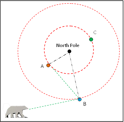
Yes, that's it. However, normally the difference is negligible. You would see it much better if you were in the direct proximity of one of the Poles. Have a look at the image below (source: https://en.wikipedia.org/wiki/Cardinal_direction)


Imagine you are on the spot A. Spot C is on exactly the same latitude, but if you look exactly in the East direction, you'll see the spot B instead. If the latitudinal parallel was painted on the ground, you would see the circle, not a straight line.

At common latitudes, it is less extreme. You'd see the Parallels as arcs if you were high above the surface enough (except at the Equator). All that is because we stand vertically, so exactly taken, our head is not on the precisely same latitudinal plane as our feet (as long as you are not on the Equator. It means you look at Parallel under your feet little bit sideways (the higher latitude, the more), and hence you do not see a straight line like on the Equator, but an arc.
 
Last edited:
1. I'm at -89.9976967 degrees latitude. Though there are other options.
2. For me, one mile between A and B, 1 one mile between A and C, and 0 miles between B and C.
3. I can. I don't even have to move. ;-)

The more illustrative answers for this, of course, is at the North Pole. And it's even more illustrative if you walk 3.14 miles due west, making point C about 2 miles from point B.
 
Are we saying that when we're looking from Birchwood, MI to the Willis Tower we're not actually looking due west, because that's not actually the shortest distance?

Yes, we can find a point in the Birchwood beach from which the Willis Tower will be exactly due west at 270° heading. However, if we continue the line along this heading further around the globe, it will not coincide with the latitude, but initially deviate to south, crossing the West coast at the Central California and then passing south of Hawaii:
Screen Shot 2016-07-05 at 17.44.25.png
After passing the point opposite Birchwood on the globe, the line will begin deviate back to north and return to the starting point from exactly due east (90°).
 
Ok, I think I got it. But, just as you said in the very beginning, it's not easy to put into words, lol.

I can probably say what helped, though:

1. Scaling up. Looking at flight paths between two cities at the same latitude - Chicago and Valladolid, for example - and seeing that the shortest route isn't due east/west, but 'curved' along the arc of the great circle. I mean, I knew that, but hadn't intuitively transposed it to places that are much closer together, such as Birchwood and Chicago, between which the shortest route - and line of sight - would also look like that on a 2D map.

[GALLERY=media, 37]Chicago-Valladolid[/GALLERY]
2. Understanding that by slicing off the top of the planet along a line of longitude, I've not only sliced off the shortest route, but also the line of sight!

3. Understanding that my 'parallel circle' is not analogous to a coin, even though they look the same.

4. The bear was good. Though I think @txt29 referred to the wrong points in his description. ;-)

5. Seeing that 'due west' doesn't correspond with the line of latitude, forming a smaller 'parallel circle' as I originally thought, but does indeed form a great circle after all. I think that was the one that got the penny to drop.

Phew. Well I hope it wasn't too painful for you guys. Funny thing is, now I've grokked it, reading over all the explanations makes perfect sense, even the ones that didn't help me get there.

Cheers! :)
 
Last edited:
So I got to thinking some more about the variances in radius and whether this might play a role in curvature equations, and I came across this calculator which claims to measure the distance to the centre of the earth given a specific set of coordinates. Pretty groovy!

http://www.summitpost.org/distance-to-the-center-of-the-earth/849764

I gave it a test run to see if there was any significant variation between two relatively close points, using the Willis Tower, Chicago and Warren Dunes State Park - subjects of Joshua Nowicki's famous 'mirage photo' - and it returned figures showing Warren Dunes as being 32.78 feet further from the centre of the earth than Willis Tower (measured to 577 feet above sea level, the surface of Lake Michigan). From Nowicki's vantage point of 230 feet above the lake this returns an extra .82 miles of visibility to the horizon, and about 37 less feet of the target object obscured.

I guess 32.78 feet might not seem a lot - but for a point closer to the water, it could make quite a big difference.
 
it returned figures showing Warren Dunes as being 32.78 feet further from the centre of the earth than Willis Tower (measured to 577 feet above sea level, the surface of Lake Michigan). From Nowicki's vantage point of 230 feet above the lake this returns an extra .82 miles of visibility to the horizon, and about 37 less feet

What figures did you put into the calculator?
 
You probably made a mistake. Both places are on almost the same latitude - 41.9142562 vs 41.8790442, so the effect of the elliptical deformation of the Globe is quite negligible. Using the calculator, I am getting the difference of their Geoid Heights of only 11.4 cm (4.4 inches). I used the coordinates 41.9142562/-86.593821 and 41.8790442/-87.635717

However, you should not forget that the horizon visibility is influenced also by other factors. Especially the atmospheric refraction has a big influence.

From https://en.wikipedia.org/wiki/Horizon#Effect_of_atmospheric_refraction:
If the Earth were an airless world like the Moon, the above calculations would be accurate. However, Earth has an atmosphere of air, whose density and refractive index vary considerably depending on the temperature and pressure. This makes the air refract light to varying extents, affecting the appearance of the horizon. Usually, the density of the air just above the surface of the Earth is greater than its density at greater altitudes. This makes its refractive index greater near the surface than higher, which causes light that is travelling roughly horizontally to be refracted downward. This makes the actual distance to the horizon greater than the distance calculated with geometrical formulas. With standard atmospheric conditions, the difference is about 8%. This changes the factor of 3.57, in the metric formulas used above, to about 3.86.
Content from External Source
 
Last edited:
What figures did you put into the calculator?
The wrong ones, by the looks of things - had my viewer/object radii mixed up. ;)

If I try again, with a slightly different method:

Coordinates for Lake Michigan: 41.905527/-87
Coordinates for Warren Dunes State Park: 41.905527/-86.604366
Coordinates for Willis Tower: 41.8789/-87.6358
Centre of earth to surface of Lake Michigan (577 feet amsl): 20894957.14 feet
Centre of earth to Warren Dunes State Park (@577ft amsl): 20894957.4 feet
Centre of earth to Willis Tower (ditto): 20894990.18 feet
Distance from WDST to WT: 53.07 miles or 280209.6 feet
Viewer elevation above Lake Michigan: 233 feet
Object elevation above Lake Michigan: 18 feet

This time I get 18.7 miles to the horizon and an obscured amount of 735.7 feet.

It's perhaps not all that interesting, and given refraction, etc, still never going to give a precise figure. But seems kind of cool that an equation utilising coordinates could be built into a curve calculator.

You probably made a mistake. Both places are on almost the same latitude so the effect of the elliptical deformation of the Globe is quite negligible. Using the calculator, I am getting the difference of their Geoid Heights of only 11.4 cm (4.4 inches). I used the coordinates 41.9142562/-86.593821 and 41.8790442/-87.635717
Interesting. I double-checked both our sets of coordinates and both were right. So something's off somewhere.

It does make sense that places at the same latitude should have a similar radius. How about places on the same longitude? If the equatorial radius is 21 miles longer than the meridional radius, would this equate to an average of 890 feet in radius difference for every 50 miles travelled?

As another test, I checked the coordinates for Genoa and Elba - two points in another popular flat earth photograph, this time more north/south - and it returned Elba as having a radius about 1900 feet longer than Genoa.

I guess if viewer elevation is important to the result, such a difference in radius would be too. Or have I gone wrong somewhere again? ;)
 
Last edited:
It does make sense that places at the same latitude should have a similar radius. How about places on the same longitude?
There are two things: the ellipsoid (flattened Earth) radius does not change along the longitude (same latitude). It only changes along the latitudes. Then there is the irregularity of the geoid (typically much smaller) - that changes in all directions irregularly.


However, you cannot use the geoid shape values at only two points (or even three of them) directly for calculating the horizon distance. You would need to design the entire exact curve between the two points. It can easily happen that you have a big bulge between the two points, limiting the sight distance. Or oppositely, there can be a depression enlarging the sight. Just look at the blue line on the diagram above, to get the idea. Additionally, at an ellipse, the bigger radius is actually at the more curved end (the Equator in case of the Earth). The Earth is flatter at the poles - the places with the shortest regular radius. Hence the sight is shorter with bigger radius at a regular ellipsoid, not oppositely as you presumed.
 
Last edited:
So are the figures returned by the summitpost calculator wrong and unusable?
I do not think they are wrong. Although I did not crosscheck them with other sources, I have no specific reason for thinking they are wrong. What is wrong, is your assumption that based only on the distances of the two endpoints from the Earth center, you can calculate the curvature and hence the horizon distance. You can't. Using a third point somewhere in the middle is a bit better, but not sufficient. You'd need a few more points, plotting the curve, and only then you could really estimate the influence of the deviations on the horizon distance. You'd also need to account for the waves, tide, wind, refraction, atmospheric conditions and perhaps other influences, to get closer to the reality.
 
Especially when you try to estimate the precise horizon distance over a water body (sea, lake), you have to count not only with the tiny deviations caused by the geoid shape, and with the optical effects (namely the refraction and the visibility), but also with the irregularities of the water surface. Waves can influence the line of the sight, but the tide can have even a bigger impact. And then you have the surface wind gradient (wind pushing water to one side, or creating a bulge), the barometric pressure (water pushed up at the locality with lower barometric pressure), water density (warmer water is less dense, and taking bigger volume), and even the local gravity deviations (though those might be already accounted for by the geoid calculator).

Check out for example this document: http://www.theweatherprediction.com/habyhints3/967/
WEATHER, LOCATION AND INFLUENCE ON SEA LEVEL

Sea level is the average sea level when averaged over the entire globe. An average needs to be made since sea level can locally vary due to local wind, tides, global wind patterns, gravity, water density, and pressure. Sea level is that location where the ocean meets the land. Average sea level is given a value of 0. Any positive value above 0 indicates the distance above average sea level. This writing looks at how sea level changes due to the factors mentioned.

Local wind: Wind direction can influence sea level. Wind blowing from the ocean toward land will help pile up water on the beach. This will increase sea level.

Tides: Often tides have the biggest influence on sea level on a day to day basis. The tides are caused by forces from the moon and the sun while the earth spins of its axis. Although the sun and moon are at a distance, they are close enough to produce a significant gravitational force. The oceans facing the moon and sun and the oceans opposite to the moon and sun will have high tide. Due to the sun and moon being at different locations, the tides are a complex mix of the influence of both the position of the sun and moon relative to a location on earth’s surface.

Global wind pattern: Just like with local winds, global scale winds will either cause water to pile toward the shore or move away from the shore. Global wind patterns are influenced by the positions of global high and low pressure systems. The winds from these pressure systems influence ocean currents and the transport of water.

Gravity: Typically gravity is given as a constant on earth’s surface as 9.81 m/s^2. This value can change slightly though depending on factors such as the density of rock below a location, the fact that the earth is not a perfect sphere, and types of rock/substances below a location.

Water Density: Water changes density with temperature. As water warms above 4 C, it will decrease in density. Thus warming water expands and takes up a larger volume. Tropical waters have a greater volume than cold waters of the same mass.

Pressure: The barometric pressure has an influence on sea level. Lower pressures cause sea level to rise and higher pressures cause sea level to lower. The influence is about 1 centimeter for each millibar change in air pressure.
Content from External Source
 
Last edited:
What is wrong, is your assumption that based only on the distances of the two endpoints from the Earth center, you can calculate the curvature and hence the horizon distance. You can't. Using a third point somewhere in the middle is a bit better, but not sufficient. You'd need a few more points, plotting the curve, and only then you could really estimate the influence of the deviations on the horizon distance. You'd also need to account for the waves, tide, wind, refraction, atmospheric conditions and perhaps other influences, to get closer to the reality.
Agreed on all of that - though I don't think I was assuming using the geoid figures would work perfectly, more asking the question and proposing it as an idea.

Actually, given that when we use a curvature calculator we already are using the distances of two endpoints measured from the Earth's centre, but ones based on the mean radius rather than the place we're actually measuring, maybe there is something in using this data. But as you say, without knowing what's going on between the two points - just as we don't when using the mean radius - it could be very misleading.

What did you think for the Elba/Genoa points? Ignoring for the moment possible 'bulges' between them, a 1900 feet difference in radii does seem rather a lot, and possibly crucial in any curvature calculations.

Are you saying it's not worth looking at? That using a radius of 3959 miles for both points is a better measure?

Then again, according to wikipedia:

Plane and geodetic surveying

Based on the considerations and true shape of the earth, surveying is broadly classified into two types.

Plane surveying assumes the earth is flat. Curvature and spheroidal shape of the earth is neglected. It is employed for small survey works where errors due to the earth's shape are too small to matter.

In geodetic surveying curvature of the earth is taken into account. This type of surveying is only employed for large survey works.

Generally the survey works below 260 kilometers radius are treated as plane and beyond that is treated as geodetic.
So perhaps if it's good enough for the surveyors it should be good enough for an ordinary fella like me. ;)
 
What did you think for the Elba/Genoa points? Ignoring for the moment possible 'bulges' between them, a 1900 feet difference in radii does seem rather a lot, and possibly crucial in any curvature calculations.

Are you saying it's not worth looking at? That using a radius of 3959 miles for both points is a better measure?
No, not at all. I do not tell it is not worth of looking at. What I tell, is that, first of all, your assumption that with bigger radius you have longer sight, is not necessarily correct. The length of the sight line depends on the curvature, and as I told, the ellipsoid is actually flatter at places with the shorter radius, not vice versa. The differential of the radius does not tell how curved the surface between the two points is. Take two points near the pole - they can have similar or even identical distance from the center of the Earth, but the surface between them will be much flatter than between two points elsewhere with great difference of radii of both end points. You simply have to find out the exact curve between the two points, to make your guess. Without it, you can't even tell whether the differential of radii has positive or negative influence on the horizon distance.
 
No, not at all. I do not tell it is not worth of looking at. What I tell, is that, first of all, your assumption that with bigger radius you have longer sight, is not necessarily correct. The length of the sight line depends on the curvature, and as I told, the ellipsoid is actually flatter at places with the shorter radius, not vice versa. The differential of the radius does not tell how curved the surface between the two points is. Take two points near the pole - they can have similar or even identical distance from the center of the Earth, but the surface between them will be much flatter than between two points elsewhere with great difference of radii of both end points. You simply have to find out the exact curve between the two points, to make your guess. Without it, you can't even tell whether the differential of radii has positive or negative influence on the horizon distance.
Yes, that makes sense: so knowing several points of radius between the observer/object points would also be necessary, to know what level of arc was between them (ie, how elliptical or circular, or even highly irregular).

PS I wouldn't assume that a "bigger radius would give longer sight", more that different radius lengths may give different lengths in sight, which could be longer, shorter, or insignificant either way. I guess I'm thinking "are there places we've been measuring where it might make a significant difference?" And, if so, "what's the most accurate way to measure this?"
 
Last edited:
"are there places we've been measuring where it might make a significant difference?"
If you ignore the geoid irregularities and count with the perfect ellipsoid, the biggest difference would be between two places symmetrically around the pole (longer horizon distance), and two places symmetrically around the Equator (shorter horizon distance). Now, with the irregularities, it is hard to tell, but it may be perhaps possible that the extremes are elsewhere.
"what's the most accurate way to measure this?"
As I already wrote earlier there are many other factors playing a role in the horizon distance, so the best way to find out would be measuring it by sight (or for example with a laser beam).
 
Ah, such nostalgia for this thread - how funny to look back on the days when I couldn't grok what a 'great circle' is. ;)

But, anyway, just to add an update, seeing as I'm here: that last notion about using a geoid calculator to work out more accurately "hidden amounts", etc - the reason it's not important is because, though one viewpoint may have a seemingly significantly increased radius over the over, it's not adding that much to its 'height' - not in the way that climbing a hill would do - but is merely making the arc between the two points very slightly less circular, and very slightly more elliptical.

Can't remember how much off the top of my head - it varies, of course - but something like a thousandth of one percent - which is nothing, in the grand scheme of these always somewhat imprecise calculations, when so many other things will have much greater effect (and certainly not worth the effort: elliptical geometry is hard).
 
Can't remember how much off the top of my head - it varies, of course - but something like a thousandth of one percent - which is nothing, in the grand scheme of these always somewhat imprecise calculations, when so many other things will have much greater effect (and certainly not worth the effort: elliptical geometry is hard).

There's a follow-up thread with the math and actual calculation here:
https://www.metabunk.org/earth-curv...ipsoid-geoid-models-for-visibility-etc.t7954/
So for the same latitude and longitude points A and B [6km apart], the distance between the points is 4.67m more on the WGS84 ellipsoid model, and the distance to the horizon is 1.87m more . However the the drop from the level plane at B only increases by 2.2mm

Hence there's really no benefit to using WGS84 instead of a spherical model to calculate "drop" and "hidden" values. Refraction effects will vastly outweigh the differences between the models.
 
Back
Top