Demonstrating the curvature of the Earth by Flying in a "Straight Line" Near the Poles

Yolo fish

New Member
A video explaining an experiment on how 2prove the shape of the earth please watch it's only 2:00 long
Source: https://m.youtube.com/watch?v=XUQTJRRu29E
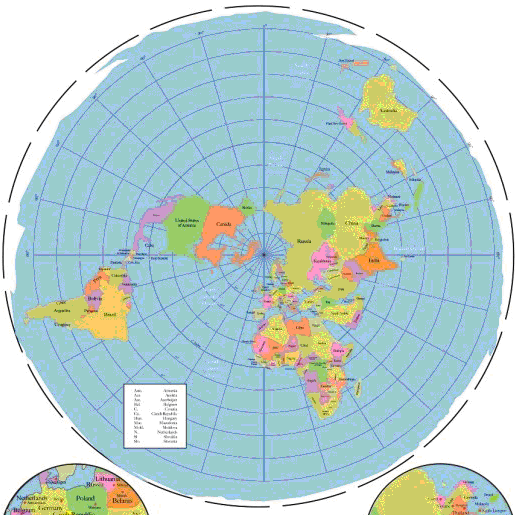
If someone faced east with a compass standing 10 miles away from the North Pole, if he flew in a airplane in a perfectly straight line from that point with out turning right or left, he would slowly start facing south east. And at the equator of a globe, you could face east or west and travel in a straight line all the way around the globe and stay facing east or west the entire time. BUT in the Southern Hemisphere/ Australia. Someone can prove to us if Australia is upside down or not. Budy needs an airplane and a compass, he simply needs to face directly east - keep in mind east and west are 90 degrees away from the North Pole. Then this guy needs to go on auto pilot and travel in a straight line with out turning right or left and he should slowly TRAVEL NORTH EAST. On a flat earth facing east or west and traveling in a straight line with out turning right or left will always force you to end up slowly facing south east.- or south west. I need someone smart to explain this better than I can.
If air planes need to turn to the right to stay facing directly east /90 degrees away from the North Pole when flying around the world in the Southern Hemisphere that would prove the globe. If the pilot has to turn to the left to stay facing east in the Southern Hemisphere that proves the earth is flat
 
Last edited by a moderator:
Then this guy needs to go on auto pilot and travel in a straight line with out turning right or left and he should slowly TRAVEL NORTH EAST. On a flat earth facing east or west and traveling in a straight line with out turning right or left will always force you to end up slowly facing south east.- or south west. I need someone smart to explain this better than I can.

How do you travel in a straight line on a curved surface? Really what that amounts to is "start flying along a great circle". But how can you do that without knowing the shape of the earth? Traditional great circle navigation involves plotting intermediate points and then calculating the heading between them. You could do it via GPS, however both those methods assume the Earth is round.

I suppose you could just say "fly visually in a straight line" - but how would you know?

Flying ten miles from the magnetic north or south pole might work, as the turning should be apparent. But I'm not sure how accurate a magnetic compass is that close to the magnetic pole (the field will be oriented nearly vertical, so a regular compass might now work). And you'd need to actually get to the South pole to perform the experiment - the existence of a south pole that you can fly around pretty much confirms the shape of the earth by itself - as does pretty much ANY navigation (or celestial observation) in the southern hemisphere.

It's a good thought experiment, but not really practical or necessary.
The only reason I said 10 miles away from the North Pole. Is just to make it easier on people's brains. I thought imagining doing this experiment close to the North Pole would make it easier to understand what the point is
 
The only reason I said 10 miles away from the North Pole. Is just to make it easier on people's brains. I thought imagining doing this experiment close to the North Pole would make it easier to understand what the point is
So how do you perform the experiment in the southern hemisphere without proving the earth is round before you even start?
 
So how do you perform the experiment in the southern hemisphere without proving the earth is round before you even start?
East and west are 90 degree angles from the North Pole and only at the equator of a sphere you could face east and travel in a straight line and stay facing east with out drifting south east or north east. So when doing this in the Southern Hemisphere pilots should drift north east. On a flat earth you would never drift north east.
 
East and west are 90 degree angles from the North Pole and only at the equator of a sphere you could face east and travel in a straight line and stay facing east with out drifting south east or north east. So when doing this in the Southern Hemisphere pilots should drift north east. On a flat earth you would never drift north east.

Again though, it's not a practical experiment.

You can actually observe the result of this experiment simply by looking at the tracks of planes flying in the northern and southern hemisphere.

20170311-135327-ax8qg.jpg

The more north you go, the more the tracks curve towards the north pole, and the same in the south and the south pole.

The longer tracks are just interpolated from great circle, as there's no tracking data. However you can see see the effect in australian flights to Perth from the East coast. They curve towards the pole.
I don't think you understand what I am saying. I'm talking about flying in Straight lines and your starting point facing east. And you should slowly face North east when flying in the Southern Hemisphere / wen flying in a straight line from that first starting point
 
The only reason I said 10 miles away from the North Pole. Is just to make it easier on people's brains. I thought imagining doing this experiment close to the North Pole would make it easier to understand what the point is.
I think Mick makes a good point in that, if you've got an aeroplane and the ability to take it to within 10 miles of both poles, you've probably already done enough to show that the earth isn't flat.

Unfortunately, to even begin to persuade flat earthers, we probably have to do more than "imagine" the experiment, we have to carry it out. For most of us, other things are probably more practicable than flying to the poles.
 
Last edited:
I don't think you understand what I am saying. I'm talking about flying in Straight lines and your starting point facing east. And you should slowly face North east when flying in the Southern Hemisphere / wen flying in a straight line from that first starting point

That's essentially what the southern tracks are doing. If they are flying roughly east/west, then they have to fly south a bit, then north a bit. At some point on the trip they will be flying due east/west. But they are still flying the shortest distance between two points on the surface.

Remember what you calling "a straight line" is actually a great circle. If it were a straight line they would fly off into space.

Let's say you actually wanted to do this experiment. Where would you perform it, and how would you know you were travelling in a straight line?
I can't believe I have to explain that not turning right or left means you are traveling in a straight line
 
I can't believe I have to explain that not turning right or left means you are traveling in a straight line

But how would you know you were travelling in a straight line. Autopilot does not simply fix the rudder, etc, in one position. Wind is variable.

But that aside WHERE exactly would you propose this experiment be performed.
 
I can't believe I have to explain that not turning right or left means you are traveling in a straight line
So how do you keep yourself from turning right or left? I get that you wouldn't be steering, but how would you account for things like the fact that the plane might be veering to one side, or that changes in the wind might send it off course? Flying straight isn't just "not steering".
 
But how would you know you were travelling in a straight line. Autopilot does not simply fix the rudder, etc, in one position. Wind is variable.

But that aside WHERE exactly would you propose this experiment be performed.
As far away from the North Pole / Closer to the "South Pole" as you can. Make a 5 hour flight on auto pilot facing east would be good on the gas for your airplane
 
Make a 5 hour flight on auto pilot facing east

"facing east" would take you in a circle. Autopilots don't really have a "straight line" setting. You can set a course or a heading, but not "don't turn". Setting a course would involve using the globe model, and would take you along a great circle.

Sorry, but by the time you've got close to the south pole you'd have already realized long ago that the earth is actually a globe - because that's how you would navigate to get there.
 
Most modern autopilots can be programmed to fly on a true track, so flying an aircraft due east or west is possible.
Though setting it to that wouldn't prove to a flat earther that we were flying on a true track, just that the instruments tell us we are. ;)
 
Though setting it to that wouldn't prove to a flat earther that we were flying on a true track, just that the instruments tell us we are. ;)

Yes I've had a prominent Flat Earther tell me that. They forget we have windows as well as instruments.
 
Flat Earth was made by people in the Northern Hemisphere. It´s made to have the Polar Star at the center of their map and such.

But what about the SOUTHERN constellations?


The most famous southern constellation is the Southern Cross. It's located near the South direction.


Now, it turns out it can be night at the same time in Brazil and Australia. So a Brazilian and an Australian can BOTH look to their south at the same moment, same night, and BOTH will see the Southern Cross constellation.

OOPS... there is a problem... if the Southern Cross is south of a Brazilian, it should happen that an Australian would need to look almost NORTH to see it! Or vice versa.

Do Flat Earthers think there are TWO Southern Cross constellations? Maybe 3, considering a South African can do the same (although not at the same moment as the Australian and Brazilian... it´s never night in the 3 places at the same time).


Using the same map above, I want to tell that my sister constantly travels to Hong Kong, from Porto Alegre, Brazil.

It´s full of connections. A Flat Earther would already point out that a scale in Dubai proves a Flat Earth.

Well, maybe it could prove IN the case of Australia to Johanesburg, going through Dubai.

But her flight goes from São Paulo to Johanesburg. Then from Johanesburg to Dubai. Then from Dubai to Hong Kong.


Now, the funny part is that the travel time between São Paulo and Johanesburg is 9 hours 45 minutes.

Johanesburg to Dubai: 8 hours 10 minutes

About 1:30 minutes longer flight.

Eh... let's look at the Flat Earth map again, shall we? The distance from São Paulo to Johanesburg in their map is at least 2x longer than Johanesburg to Dubai. Most likely 3x the distance!*

So it should take from 16 to 24 hours to get from São Paulo to Johanesburg, not 9 hours!

*draw the map to scale in a 3D program and calculated. SP to Joha is actually 4x the distance from Joha to Dubai. Travel time should be about 32 hours!

Another big problem with their model:

7 am in Wellington, New Zealand. 4pm in Brasilia.

Impossible in their map with their sun model.
Read carefully, ANYWHERE on our earth, if you are facing 90 degrees east, or 180 degrees west. - And fly in a straight line in a airplane/ auto pilot for 5 hours. The "N" on the pilots compass will always slowly point towards his back side of the airplane. He would need to turn towards the North Pole to stay facing directly East or West. BUT at the EQUATOR on a "ball earth" this pilot could fly in a straight line/ auto pilot all the way around the world and stay facing directly East or west the entire time. Guess what happens in the Southern Hemisphere on a silly ball earth. Now, Someone in Australia with a airplane can prove if Australia is upside down or not by facing Directly East and flying in a straight line. The "N" on his compass should SLOWLY POINT TOWARDS THE FRONT SIDE OF HIS AIRPLANE. He would need to TURN AWAY from the North Pole to stay facing directly 90 degrees East. Someone please spread this message
 
Surely on the 'flat earth', any attempt to fly east OR west in a straight line would result in your aircraft heading south(ish) with the need for constant corrections north to correct it, this would be true in either the North or south hemispheres (regions) on the flat earth model.
flat earth east - west problem.jpg
Now I know that due west from London will not leave me flying down the Andean coast of South American, and due east will not dump me over the southern Indian ocean. Same for a southern hemisphere departure, say Wellington, on the flat earth model due east or due west will sooner or later leave you heading for Antarctica and a collision with the great mystical 'dome'.

So unless I'm missing something, on a flat earth the whole straight East / West straight line idea is useless* , and any attempt to use this method to 'prove' flat earth would only serve to debunk it.

*as are any standard NSEW directions on a flat earth model - which is why Terry Pratchett used Hubwards / Rimwards / Turnwise / Widdershins for directions in his Discworld novels.
 
Last edited:
Read carefully, ANYWHERE on our earth, if you are facing 90 degrees east, or 180 degrees west. - And fly in a straight line in a airplane/ auto pilot for 5 hours. The "N" on the pilots compass will always slowly point towards his back side of the airplane. He would need to turn towards the North Pole to stay facing directly East or West.
Given your confidence in this, I can only assume that this has been corroborated by numerous independent tests. Can you share a link to any of them?
 
Given your confidence in this, I can only assume that this has been corroborated by numerous independent tests. Can you share a link to any of them?
@Yolo fish is just suggesting a possible test to see if the world is flat. The problems with the test are discussed above.
 
I already know this experiment would prove the earth is flat.

[mod: off topic theories removed]
 
Last edited by a moderator:
I already know this experiment would prove the earth is flat.

[mod: off topic theories removed]

The Flat Earth is disproved by the tracks commecial airlines plan their flights by.

Those tracks are congruent with operating on a sphere.

The navigation systems on the aircraft are programmed to work on a sphere and the observations of flight crews are congruent with operating on a sphere.

Should the Nav systems fail, the crews would revert to manual navigation techniques in which they had to demonstrate competence, in order to acquire the license to fly the aircraft.

Those techniques are based on operating on a sphere. To do otherwise could mean loss of the aircraft.

Flying long haul routes, particularly polar routes far from diversion airports, is not a theoretical exercise.

Perhaps you could explain why, when flying almost due South last week from Asia, we observed the Southern Cross rise above the southern horizon and move clockwise until eventually disappearing below the horizon at right angles to the initial observation?
 
I can't believe I have to explain that not turning right or left means you are traveling in a straight line
Though I think everything here has been pretty-well discussed, I'll address this one point, and please excuse the fact that this explanation is a little bit long. Now, I could try to look up information online explaining the complications of flying in a straight line, but I'll violate protocol a tiny bit (no references) and give you an example of attempting to travel in a straight line from my own experience.

I do lots of trips in canoes and small rowboats, and when crossing a big lake, it's nearly impossible to go a straight line without the aid of a GPS (and of course, the workings of a GPS are already based on the fact that the Earth is a sphere, so we should avoid that method here). Following a compass heading, or aiming directly at a particular point on the far shore, do NOT result in straight-line travel if there's any bit of cross wind.

First method: Holding a compass heading
If you hold a steady heading on your compass, you end up going in a direction that's "off" a bit from your heading, simply because even the slightest cross wind pushes the boat a tiny bit sideways for each increment of forward travel. You can't see evidence for this sideways component of your travel except when the wind is fairly strong (it's much easier to see this in a rowboat than in a canoe, because when rowing you are looking backward and can see if the boat drifts sideways relative to the alignment of its own wake). The farther you travel on your chosen compass heading, the farther off your intended straight-line route you end up. Sea kayakers who travel distances of several miles across open water, such as when paddling to an offshore island, have not just cross winds but also ocean currents and tides that they must account for, and as those currents change from place to place, the degree to which their direction of travel is at a diagonal from what their compass says it is will vary, and thus, a GPS track of their course is anything but straight. Believe me, when you are out on the water, hundreds of yards or a few miles from any fixed landmark, you just can't perceive deviations from your intended heading until the deviation has been going on for an extended time. Being high above the ground in an airplane would likely be worse.

Second method: point the boat at your destination
If I'm paddling across a lake and I aim the boat directly at a visible point on the opposite shore, and if there's any cross wind, I end up paddling a curved route, with the degree of curvature getting steadily sharper as the trip progresses. That's because it takes a while for the sideways drift due to wind to be apparent when looking past the bow of the boat toward the faraway destination. Once you perceive being off course, if you turn into the wind a little bit to again point the boat at your destination, but that doesn't stop the sideways drift - it only puts you on a new heading, different from the one you originally intended. And that heading is skewed from the actual direction of travel, just like the first. By the time you have made several such corrections, your corrected heading is very much different from the first heading, and since each correction is in the same direction, that's what results in your actual path being a curve that gets steadily sharper and sharper. If you equipped the boat with something like an aim-able rifle sight, and pointed that sight at your destination (and this would be at an angle to the boat's heading), you could then correct your heading to account for cross wind pretty accurately, as long as you kept looking through that sight (naturally that would be awkward, but it would work). When paddling straight across a river, you can do exactly the same thing with "good enough" accuracy to correct for the current just using your eyes, since the distance traveled is so short.

I hope you can see that trying to correct for cross winds when flying (and of course the cross winds will not be constant from one location to the next) so accurately that you would actually know that you are going a straight line, would be virtually impossible without using instrumentation of some kind.

I think people here appreciate your effort to prepare this thought problem to show that the Earth is a sphere, but what we really need when it comes to convincing the flat-earthers of this is a demonstration that ordinary people can do, and flying a straight line with nothing other than the best of intentions to guide you would fail in that regard.
 
Last edited:
I think something is being lost in trying to focus on the technical problems with the proposed experiment (e.g., the practical difficulties of simply aiming a plane in one compass direction and flying "straight" for some period of time without reliance on instrumentation). I think we can see where the experimenter fails more fundamentally in his assumptions if we look at what he is trying to say with two simplifying factors:
  1. We have a plane that can travel without interference towards a given compass direction at a set altitude (I think this is what @Yolo fish means by "straight"); and
  2. The compass directions are all based off of true north.
With these simplifying assumptions, however, the claim in the video that a plane would necessarily veer towards the equator if traveling "straight" east or west on a spherical earth is mistaken. The plane's route would simply follow the line of latitude on which it started its journey "straight" around the earth and not veer towards the equator at all. The assumption that it would veer towards the equator seems to be based on a belief that the directions of east and west are determined by poles located some point on the equator. To be more precise, @Yolo fish seems to mistakenly imagine that if you were looking at the surface of one side of the visible spherical earth from space, then, for any given point located along the north-south center line of such visible surface, the "east pole" would exist at the east-most point visible on the equator from that view and the "west pole" would exist at the west-most point visible on the equator from that view. You can see this when he draws his diagram in the video starting here.
 
I did not read the entire thread, but saw that flying straight is being claimed to be somehow difficult. In fact it is easy using simple navigation means - the first comes to the mind visually aligning the path with two (or more) points (for example high mountains), or using a laser beam for the navigation, but there are other ways as well.
 
The plane's route would simply follow the line of latitude on which it started its journey "straight" around the earth and not veer towards the equator at all.

The problem with this statement is easy to illustrate. Imagine that you are just one mile from the geographical north pole, and you point your airplane to the east, and fly the best straight line that you can, with that line being a geometrically straight line, not one based on what your compass says or what one would deduce by plotting his location on a map (not that a compass would be of any use at this location, but how one defines the line as "straight" bears mentioning). If what you say is true, you should end up flying a circle with a radius of one mile. In that case, an observer at the pole could actually watch the plane flying circles around him. Yes, that would be "flying straight east", but even using visual cues alone, the pilot could see that his route was a circle and not a straight line.

Take this to an extreme and get much closer to the geographic pole, and if your statement were true, a person on foot could "walk a straight line" and end up doing circles. Clearly that's not what would happen. In fact, any straight line that a person chose to walk would quickly develop an ever-increasing southward component.
 
Last edited:
I did not read the entire thread, but saw that flying straight is being claimed to be somehow difficult. In fact it is easy using simple navigation means - the first comes to the mind visually aligning the path with two (or more) points (for example high mountains), or using a laser beam for the navigation, but there are other ways as well.

The idea was to be facing directly east or west (using the magnetic poles as reference), and then continue in a "straight line", and see how the magnetic heading changes. I don't think either of your methods would give sufficient range to actually work for this experiment to yield a result.

Like I said earlier, if you actually manage to carry out the experiment, you'd probably realize before you started that the Earth is spherical, as you'd need to use spherical earth navigation to actually get near Antartica. It's a thought experiment, and really there's lots of easier demonstrations.
 
I think something is being lost in trying to focus on the technical problems with the proposed experiment (e.g., the practical difficulties of simply aiming a plane in one compass direction and flying "straight" for some period of time without reliance on instrumentation).

.......

To be more precise, @Yolo fish seems to mistakenly imagine that if you were looking at the surface of one side of the visible spherical earth from space, then, for any given point located along the north-south center line of such visible surface, the "east pole" would exist at the east-most point visible on the equator from that view and the "west pole" would exist at the west-most point visible on the equator from that view. You can see this when he draws his diagram in the video starting here.
I'd certainly missed that, but after viewing the video again I agree.

I'd struggled to figure out what he was talking about when he said compass North would "move" backwards or forwards, but it does appear that Yolo Fish is basing the experiment on travelling towards an East or West "Pole" and of course there's no such thing (either on globe or flat Earth).

Travelling true East or West means you'd follow a line of latitude in a circle until you reached your starting point, not get closer or further away from either pole, and again that's true on the actual globe or the imagined flat Earth.

Ray Von
 
The problem with this statement is easy to illustrate. Imagine that you are just one mile from the geographical north pole, and you point your airplane to the east, and fly the best straight line that you can, with that line being a geometrically straight line, not one based on what your compass says or what one would deduce by plotting his location on a map (not that a compass would be of any use at this location, but how one defines the line as "straight" bears mentioning). If what you say is true, you should end up flying a circle with a radius of one mile. In that case, an observer at the pole could actually watch the plane flying circles around him. Yes, that would be "flying straight east", but even using visual cues alone, the pilot could see that his route was a circle and not a straight line.

Take this to an extreme and get much closer to the geographic pole, and if your statement were true, a person on foot could "walk a straight line" and end up doing circles. Clearly that's not what would happen. In fact, any straight line that a person chose to walk would quickly develop an ever-increasing southward component.

You are of course correct that the "straight" line conceptualized by @Yolo fish is not, in fact, straight and you illustrate that well with the example of the shrinking circular route near one of the poles. My comment was not meant to suggest it was truly straight (which is why I put it in quotes); I was just trying to bridge the gap between what he seems to be trying to claim and how people here are interpreting it. As I understand him, his fundamental conceptual issue is that he imagines east and west are determined by arbitrary poles along the equator. If we can help him see how that is not the case, then I believe he will understand why his experiment is a non-starter without even needing to get into the technical difficulties of performing his experiment in real life.
 
You are of course correct that the "straight" line conceptualized by @Yolo fish is not, in fact, straight and you illustrate that well with the example of the shrinking circular route near one of the poles. My comment was not meant to suggest it was truly straight (which is why I put it in quotes); I was just trying to bridge the gap between what he seems to be trying to claim and how people here are interpreting it. As I understand him, his fundamental conceptual issue is that he imagines east and west are determined by arbitrary poles along the equator. If we can help him see how that is not the case, then I believe he will understand why his experiment is a non-starter without even needing to get into the technical difficulties of performing his experiment in real life.

I don't think that's what Yolo is saying. As far as I can tell he understands the simple geometry, he just thinks that the Earth is flat, and that this test would demonstrate that. The "straight line" he envisages is an actual straight line on a flat earth, or a great circle in the real world.
 
I don't think that's what Yolo is saying. As far as I can tell he understands the simple geometry, he just thinks that the Earth is flat, and that this test would demonstrate that. The "straight line" he envisages is an actual straight line on a flat earth, or a great circle in the real world.

I get that based on what he's written; what I'm addressing is the video he posted. In the video he describes in more detail exactly how and why he thinks his proposed experiment would tell us if the earth was spherical. In his view, someone conducting the experiment would know the earth is spherical if, when attempting to travel "straight" east via a plane, their route inevitably lead them towards the equator. You can see him drawing diagrams to that effect starting here. Unless I am missing something, I think there is a fundamental misunderstanding of geometry at play here.
 
In his view, someone conducting the experiment would know the earth is spherical if, when attempting to travel "straight" east via a plane, their route inevitably lead them towards the equator.

No, the experiment is to travel in a straight line after facing east (or west). On a globe this does take you towards the equator in both hemispheres because you are traveling along a great circle.

20170411-080627-ec5cr.jpg

These lines are a rough illustration, but are essentially correct. Here's a line if you start standing on the 50° south line of latitude, face east, then proceed in a "straight line" (not turning left or right, but going round the globe on a great circle). Essentially you start out on a tangent to the 50° line of latitude.
20170411-081229-26lv4.jpg

Same line from a side view, it looks like it curves towards the equator:
20170411-081324-ctnjq.jpg

So the thought experiment is correct, it's just not practical, or possible to do without realizing the Earth is round before you start.
 
Back
Top