Claim: Australia was not visible from the moon for Apollo 11 Broadcasts

mudr0

New Member
A claim [on Facebook] is being made that Australia was not visible from the moon at the time logs indicate and would not be able to transmit a direct signal to the Parkes Radio Astronomy Site in New South Wales, for television broadcast. The claimant is borrowing some of his argument from AULIS, specifically from this page:

http://www.aulis.com/moon-earth.htm

External Quote:
This evidence relates to the televised live broadcast of the Apollo 11 moon landing of Buzz Aldrin and Neil Armstrong on July 20, 1969, at 20:17 UTC.

The purported live broadcast from the Luna surface is said to have been broadcast directly from the Luna surface to the Parkes Radio Astronomy Site in New South Wales. In order for the Parke's Radio Astronomy Telescope to receive any signal originating from the Luna surface it would have to have a direct line of sight between the antenna from which the signal was being sent and the Radio Astronomy Telescope Receiver.

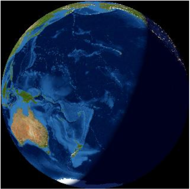
The images we are provided with by NASA (Which are fake composite images - made up of two separate images) Show Australia on the top left at approximately 11'oclock coming into view, using the starrynight software we know without doubt that this could not be the case, notwithstanding that Earth's orientation is utterly wrong from what we should have seen at that time, and we know exactly what time reference it was because we have that information in the NASA flight log. What you ought to have seen is the Atlantic Ocean with South America and part of Africa (as seen in "b, Atlantic Ocean with South America and part of Africa" below. Australia was neither visible from the surface of the Moon, nor from lunar orbit at that time.

Knowing Australia was neither visible from the surface of the Moon, nor from lunar orbit I questioned why NASA would place Australia in their fake composite images, I realized that NASA did this because it was necessary to have Australia visible for the direct live link television broadcast.

However as stated using the starry-night software it is extremely apparent that Australia was not visible, indeed Australia at that time was almost on the other side of the planet, without Australia being visible it would not have been possible to have a direct television signal link between the surface of the moon and Australia, this is absolute, irrefutable evidence that it was impossible for NASA to broadcast live from the Luna surface at the time stated.

I provide the links by way of evidence to substantiate my assertion that it was absolutely impossible for the live broadcast to have occurred from the Luna surface and put the reader or any researcher or indeed NASA to strict proof that contradicts this irrefutable evidence.

Earth photographs taken during the Apollo 11 mission
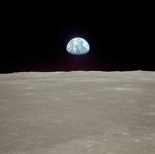
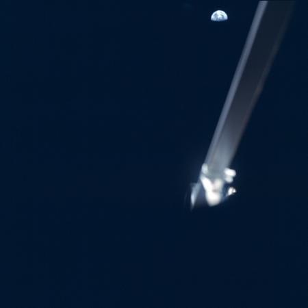
a) Part of frame AS11-44-6553 from lunar orbit.
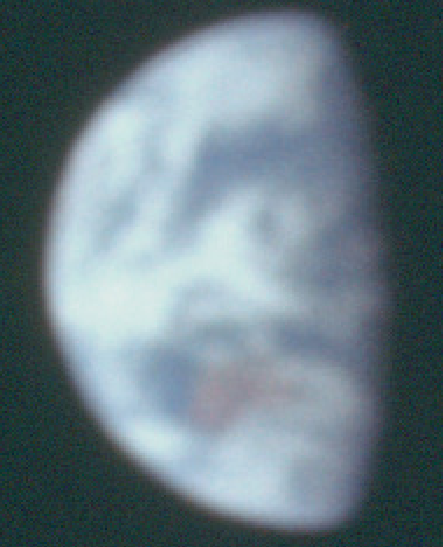
b) Part of frame AS11-40-5924 from the lunar surface.

Atlantic Ocean with South America and part of Africa images of Earth visible from the Moon at specific elapsed times (GET):
a) 85 hr 55 min, Rev 6; sleeping time for the crew, the CM is behind the Moon
b) 100 hr 12 min, undocking the LM from the CM on Rev 13
c) 110 hr 50 min, the crew on the lunar surface – the two images with Earth.
https://www.hq.nasa.gov/alsj/a11/im...yxZYR3uCgDHd3v3p1RjbBE0haUN_qY5wjcw85RCHd_vl0

52312518_2284217081856284_81327860039548928_n.jpg


52134177_2284217621856230_944900239708389376_n.jpg
 
Last edited by a moderator:
(Your post has a problem. The link and the material in the external source box don't match! The material in the box is not from this link to the AULIS site. This is confusing.)


There are two interwoven claims being made here.

1. Australia was not in line of sight at the time of the TV broadcast.

This claim is being made by someone unspecified. You haven't included a link. But your material inside the external source box is from that person... who has copied some material from the AULIS site written by "Phil Kouts PhD."

2. Photos are faked. Australia is shown in fake photos to account for the claim that the tracking station receiving the broadcasts from Tranquility Base was in Australia.

This is an expansion on material from the AULIS site you have linked to. The claim on that site is merely that there are inconsistencies with two Apollo 11 photos; therefore they are probably faked. I'll deal with that in a second post.


Claim One is based on the simplest kind of error. The times are incorrect.

Unknown source, quoted in OP:
External Quote:
This evidence relates to the televised live broadcast of the Apollo 11 moon landing of Buzz Aldrin and Neil Armstrong on July 20, 1969, at 20:17 UTC.
The Author has not accounted for the fact that the EVA and the broadcast did not start until 6 1/2 hours after the landing.

https://en.wikipedia.org/wiki/Apollo_11

External Quote:
Commander Neil Armstrong and lunar module pilot Buzz Aldrin, both American, landed the Apollo Lunar Module Eagle on July 20, 1969, at 20:17 UTC. Armstrong became the first person to step onto the lunar surface six hours later on July 21 at 02:56:15 UTC.

https://history.nasa.gov/SP-4029/Apollo_11i_Timeline.htm

Important UTC times from NASA Apollo 11 Timeline:

External Quote:

LM lunar landing. 20:17:39 20 Jul 1969

EVA started (hatch open). 02:39:33 21 Jul 1969

First clear TV picture received. 02:54:00

1st step taken lunar surface (CDR) 02:56:15

Passive seismometer deployed. 04:27:42

1st passive seismic experiment data received on Earth. 04:40:39

EVA ended (hatch closed). 05:11:13


http://www.parkes.atnf.csiro.au/news_events/apollo11/

External Quote:

Three tracking stations were receiving the signals simultaneously. They were CSIRO's Parkes Radio Telescope, the Honeysuckle Creek tracking station outside Canberra, and NASA's Goldstone station in California.

The signals were relayed to Mission Control at Houston. During the first few minutes of the broadcast, NASA alternated between the signals from its two stations at Goldstone and Honeysuckle Creek, searching for the best quality images. When they switched to the Parkes pictures, they were of such superior quality, that NASA remained with the Parkes TV pictures for the remainder of the 2 1/2-hour telecast.

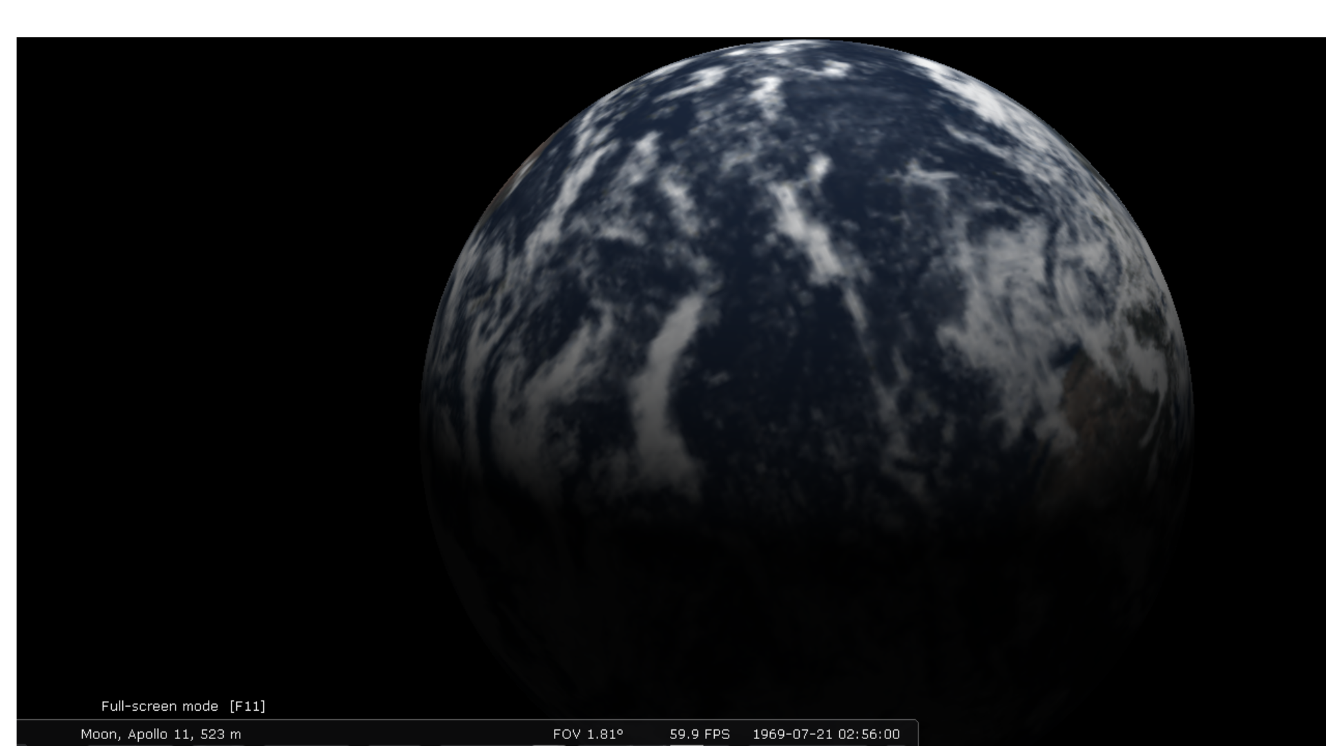
The Parkes Radio Telescope is in New South Wales - the southeast corner of Australia - which is what we see in the view below, just on the upper left edge of the visible Earth.

Stellarium view of Earth from Apollo 11 landing site; 2:54 UTC. First clear TV picture received.
6a0da264145b6511c591845e74548818.png


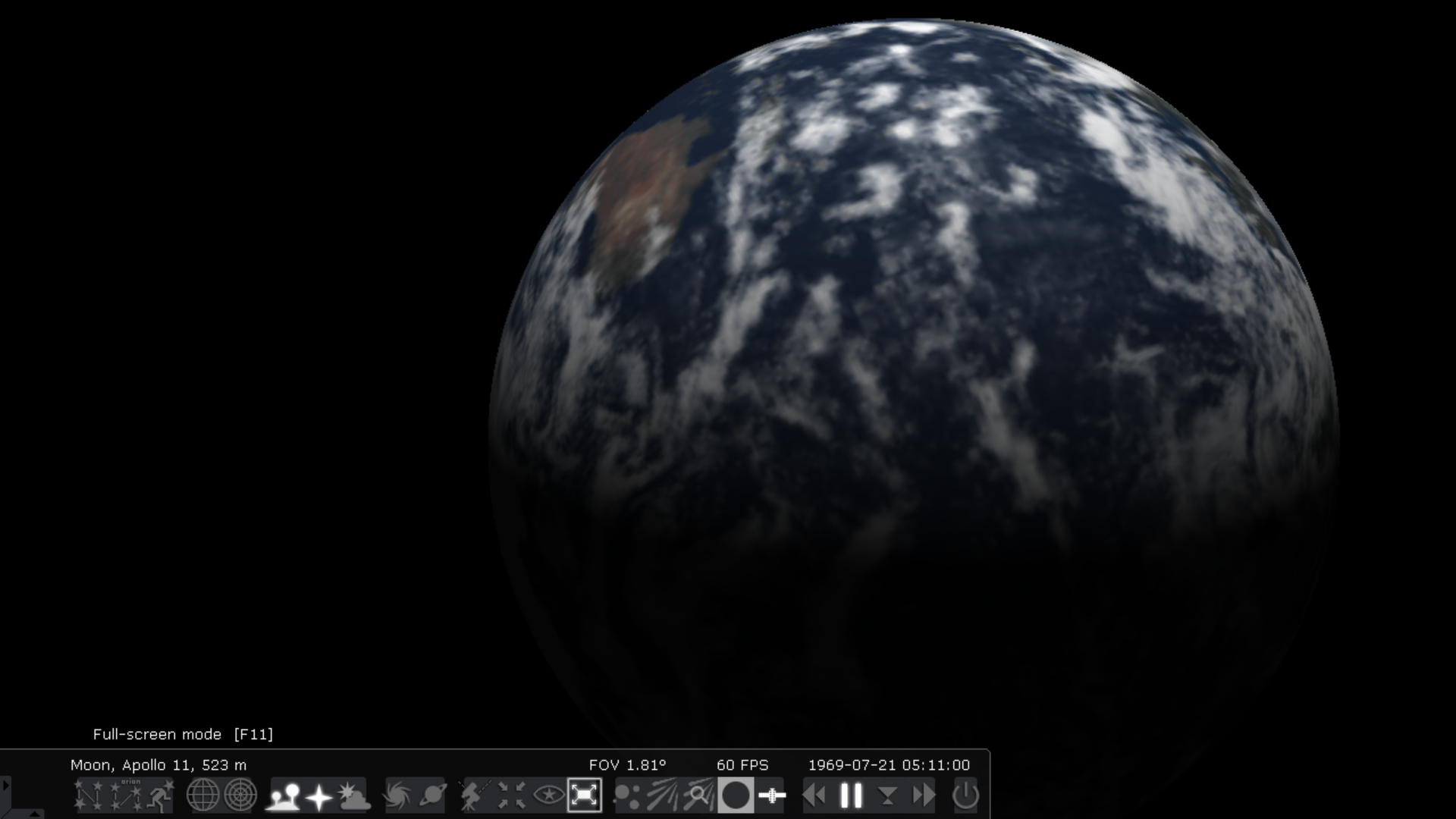
EVA ended (hatch closed). 05:11 UTC
b78be1328e0f4e8653b03462935c6ef2.png


And the actual Apollo 11 photos. Small b is from a photo taken during the EVA.
View attachment 36124
 
Last edited:
This second post will concentrate on the material from the AULIS site alone. (This is the site of "Phil Kouts PhD" which is a pseudonym for... someone.) All material from inside the external source boxes is from: http://www.aulis.com/moon-earth.htm

The second thing to account for is when and from where the two photos presents were actually taken.

External Quote:

Earth photographs taken during the Apollo 11 mission
a) Part of frame AS11-44-6553 from lunar orbit.
b) Part of frame AS11-40-5924 from the lunar surface.

https://www.hq.nasa.gov/alsj/a11/im...yxZYR3uCgDHd3v3p1RjbBE0haUN_qY5wjcw85RCHd_vl0

View attachment 36124

From the mission documents one can confidently conclude that these photos were taken with the Hasselblad camera fitted with a 250 mm focal length lens used on the orbiting Command Module (CM). One can only guess as to why there was no such enthusiasm when it would be most expected – when the astronauts stepped onto the surface of the Moon.

06b3018639c949b6c5f06f425178d166.jpg


Figure 3. Earthrise before Apollo 11 landing
Figure 3 is AS11-44-6553 from this series. The Image Library states that these pictures of Earth were taken just before the landing. They are described as: 'View of the Earth from the Command Module Columbia, possibly at AOS on either Rev 12 or Rev 13'. (Retrieved from the Apollo 11 Image Library on 28 December 2006.) Here, the AOS stands for "Acquisition of Signal" from the CM appearing from behind the Moon.

'In looking at Earth, Australia is at the left, just above the lunar horizon.' This comment accompanying AS11-44-6547 in the Apollo 11 Lunar Surface Journal is valid for each photo in the series.

Again, there is no indication in the audio record of communications with Houston that anybody is actually taking these historic pictures.

The cloud pattern in Figure 3 (taken from lunar orbit) is remarkably similar to those in AS11-40-5923 and AS11-40-5924. What is the time interval between these two series of pictures? Unfortunately, the exact timing of taking these 18 photos is not mentioned in the Image Library, there is only that vague reference to 'Rev 12 or Rev 13'.

But there is a clue: Australia is seen in both pictures. The continent in the frames from orbit is in exactly the same place as in the photos from the lunar surface. What a perfect match! To obtain this correspondence, the time interval between the two photos should be quite precisely 24 hr and 55 min.

Actually, this is a considerable restricting factor. If one accepts that the photos from orbit were taken before the lunar landing, and since the two acclaimed photos from the surface were taken at 110 hr 50 min. then there is no choice but to admit that the 18 photos were taken from lunar orbit at approx. 86 hours 00 min GET.
In other words the one he has labeled b is purportedly from the surface of the Moon during EVA. The one he has labeled a was taken from the Command Module.

He presents this as conundrum because:

1. They must have been taken at the same time because the cloud patterns match.
2. They show the same view of Australia.
3. The command module photos were taken before the landing.
4. So perhaps b was taken a day later. "To obtain this correspondence, the time interval between the two photos should be quite precisely 24 hr and 55 min. What a perfect match!" (And what about those clouds?)

But #3 seems to be his interpretation of what NASA says.

External Quote:
AS11-44-6553 from this series. The Image Library states that these pictures of Earth were taken just before the landing. They are described as: 'View of the Earth from the Command Module Columbia, possibly at AOS on either Rev 12 or Rev 13'. (Retrieved from the Apollo 11 Image Library on 28 December 2006.) Here, the AOS stands for "Acquisition of Signal" from the CM appearing from behind the Moon.
I suspect the two photos were taken at about the same time. I haven't got time just now to work that out. Maybe someone else can take over.
 
Last edited:
06b3018639c949b6c5f06f425178d166.jpg


Figure 3. Earthrise before Apollo 11 landing
Figure 3 is AS11-44-6553 from this series. The Image Library states that these pictures of Earth were taken just before the landing. They are described as: 'View of the Earth from the Command Module Columbia, possibly at AOS on either Rev 12 or Rev 13'. (Retrieved from the Apollo 11 Image Library on 28 December 2006.) Here, the AOS stands for "Acquisition of Signal" from the CM appearing from behind the Moon.

well this bit, the Image Library says
tt.JPG


and 6549 is basically the same shot
upload_2019-2-17_19-27-23.png
 
Earth photographs taken during the Apollo 11 mission
a) Part of frame AS11-44-6553 from lunar orbit.
b) Part of frame AS11-40-5924 from the lunar surface.
i guess it would be helpful to time 40-5924
924.JPG


and the first step on the moon is labeled as 109:24:00ish (GMT/UTC 02:56:15 July 21, 1969)

first step.JPG
 
(Your post has a problem. The link and the material in the external source box don't match! The material in the box is not from this link to the AULIS site. This is confusing.)

This claim is being made by someone unspecified. You haven't included a link. But your material inside the external source box is from that person... who has copied some material from the AULIS site written by "Phil Kouts PhD."

The claimant is someone from a facebook discussion I'm having with. During my own Google search I found that there was some material from the claimant that was derived from AULIS. I did mention in my description though that only some of his argument came from AULIS. Sorry for the confusion.

Many thanks for your helpful detailed responses.
 
Not sure how this one escaped me, what with Earth in Apollo images being something of a specialist subject and all, apologies if this is no longer any use and for the mild thread necromancy.

Much of the relevant detail has been covered, namely that not only is it an extremely simple task to use any number of astronomy software packages and websites that will display the Earth in its proper configuration (in terms of the landmasses and oceans on view, the placement of the terminator and its position in the lunar sky), but also to check basic facts.

There is an extremely good website discussing the role of Australia's receiving stations in the Apollo mission generally, and Apollo 11 in particular: https://www.honeysucklecreek.net/msfn_missions/index.html

The owner of the site is a very nice gentleman and is happy to correspond with people who have an interest in the subject. It would not have been difficult for the Aulis writer to have done some fact checking, or the person with whom the OP was having the discussion.

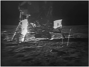
While there is no specific mention of the Earth being photographed on the surface during the Apollo 11 EVA, there is a record of it being photographed during the broadcast. Here is a screenshot from the broadcast of Aldrin taking a couple of photographs by the base of the LM:

588a13d6b08a0b96bf67e25307b6bb86.png


The crew also discuss what they are doing as they try to get the photographs (already included in the posts above)

External Quote:

110:50:26 Aldrin: Just too big an angle, Neil.

110:50:34 Armstrong: Yeah. I think you are right. (Long Pause)
In fairness not all versions of the EVA footage show the full width of the broadcast, [particularly the restored ones), so most people won't have seen that particular view. Most of the youtube videos just show Buzz's shadow until he emerges into view to take the subsequent images of the LM footpads.

The Apollo 11 Earthrise image shown in a previous post was taken approximately 30 minutes earlier, as indicated by the gap between the Earth limb and the Australian coast.

I'm not sure the Stellarium interpretation given above is correct - my own calculations show Australia rotated much more into view by hatch closure, and Fourmilab's Earthview (which is definitely using UTC) of the view from the moon at the time of the surface image shows this:

4a5c8dc9a9cad8b3f669309ba93e26e6.png


There were also images taken from inside the LM after the EVA showing Earth, and while they are not perfectly in focus Australia is clearly visible, eg AS11-37-5506

6b600012bb1d37efbbad3ec0fcb52b03.jpg


937e24e0d40098b9a43f8215ef9e9846.png


Australia has not only visibly moved, but it has moved in a way that is completely consistent with the mission timeline.

All of the images of Earth show views completely consistent with the historical records and documentation and can be verified by up to 3 different weather satellite images, all of which were publicly available at the time.
 
I'm not sure the Stellarium interpretation given above is correct - my own calculations show Australia rotated much more into view by hatch closure, and Fourmilab's Earthview (which is definitely using UTC) of the view from the moon at the time of the surface image shows this:

4a5c8dc9a9cad8b3f669309ba93e26e6.png

b78be1328e0f4e8653b03462935c6ef2.png


I think the rotation is the same. It's the tilt that's different, with the Stellarium version showing the northern hemisphere tilted toward the camera.
 
Last edited:
Back
Top