Catalina Island Being Obscured by the Curve, from Huntington Beach

Mick West

Administrator
Staff member

Source: https://www.youtube.com/watch?v=qluJ2vAnNaw


I went to a Flat Earth conference and one of the attendees gave me five photos of Catalina Island and asked me to explain why it's visible if the Earth is a Globe.

Metabunk 2019-05-28 14-09-22.jpg

The details are in the video, but simply put I replicated his view in Google Earth, fitted the photo, and saw a bunch was hidden behind the curve.

A couple of interesting points distinguish this example:

Firstly, it's a full-spectrum photo, meaning you get more detail through the haze with the addition of infrared. Adding a 760nm (or even 720nm) filter would have vastly improved this though. I highly recommend using a filter on a full spectrum camera for this type of observation.

Secondly, I often create the "flat-earth view" of a location by raising up the camera. But here I just turned off the ocean surface! This allowed me to place the camera exactly at the original view location, removing some of the differences in heights of hilltops we sometimes see.

[A "flat earth view" is a simulation of what the view would look like on a flat earth. You can't get it perfect in Google Earth, but with a mountain 30+ miles away you can get something very close by raising up the camera to look over the curve. This new trick of turning off the water gives you something even closer, almost perfectly accurate at screen resolution]

Catalina is an excellent demonstration of the curve, because it has a distinctive profile, and is a good distance (20-50 miles) away from beaches accessible to over ten million people.
 
Last edited:
[Mod: here's a similar set of observations of Catalina]


Source: https://www.youtube.com/watch?v=tlklV8asVv0
44:30 on the video

funny that they couldn't see the huge casino,which is 12 stories high...… not to mention the fact that their "diagram" of the area around eagle rock, they drew a line saying that was 140ft high.... while the adjacent mountain has an elevation of 2000ft + such a joke!

I think it was John Quantum Eraser that was talking about the views from huntington and also redondo. the video had lines drawn showing the 140ft elevation line above sea level. however, it in no way matched reality as shown by the line being near half the distance to the top peak , which was 2000ft.


Metabunk 2019-06-03 05-19-09.jpg
 
Last edited by a moderator:
[compare]
Metabunk 2019-06-03 06-07-09.jpg Metabunk 2019-06-03 06-07-55.jpg
[/compare]
(drag slider to compare)
It's more like 280 feet behind the curve. The view position is also more like 15 feet feet up, as it's on a harbor wall. But the details are really irrelevant. There's 280 feet of Catalina Island hidden behind the curve of the Earth.
 
Catalina (and similar) observations are an intractable problem for Flat Earth. I brought it up in a FE group, and I was blocked:


Metabunk 2019-06-20 11-25-35.jpg
Metabunk 2019-06-20 11-26-42.jpg
 
If they believe that things disappear bottom first on a flat surface (something I’m sure they could never prove) then you’ll never win this kind of argument.
 
If they believe that things disappear bottom first on a flat surface (something I’m sure they could never prove) then you’ll never win this kind of argument.
Some days, it's really hard to believe these guys are serious.

More on topic, is Nathan Thompson really going to ignore the massive and obvious atmospheric distortion present in that particular observation, along with similar observations that show obstruction by the horizon without significant distortion?
 
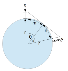
I remember back in the day (just a couple years ago), many flat earthers were neglecting viewer elevation. For this geometric figure:

y is a function of x, r, m, and n. Flat earthers used to set x = 0 even when they were observing from elevations significantly above sea level, and x should have been perhaps 100 meters. Now, they generally seem to understand the difference. They even seem to understand that refraction can let you see around the curve of earth a bit. So at this point I'm starting to wonder if some of them are just Poes. Nathan Oakley and Red Pill Philosophy, for example, are very likely Poes. I even wonder whether there really are any flat earthers or not sometimes.

But to take the flat earthers seriously, can anyone explain this "disappearing from the bottom up on a flat surface" argument for me from the flat earther point of view in an articulate manner in relevance to a physical observation? I just don't understand how or why someone can see half of the CN Tower obstructed by the ocean and think the water surface is macro-flat. (I just made up a word because water has waves. Microflat. Macroflat. Macrocurved. Whatever).
 
IMG_2982.JPG

Just browsing some of my old photos, and found this from 2007 when a friend took me to Catalina in a Cessna. Just another perspective, showing the true shape of the Island.
 
I look at #4 and all I'm thinking is nothing undermines their defence more than blocking Mick for trying to debunk a claim; it just makes them look insecure. Granted it was only a temporary block but it still doesn't look good.
 
I look at #4 and all I'm thinking is nothing undermines their defence more than blocking Mick for trying to debunk a claim; it just makes them look insecure. Granted it was only a temporary block but it still doesn't look good.
That Facebook group was shutdown.
 
I look at #4 and all I'm thinking is nothing undermines their defence more than blocking Mick for trying to debunk a claim; it just makes them look insecure. Granted it was only a temporary block but it still doesn't look good.

I don't know... They bring up some pretty compelling arguments to dispute you Mick.... I especially like the one where they say that you are using "2nd grade arguments"... and they do it with First grade rebuttals. What the heck are they talking about with Orca whales and "bottom Up" disappearance of the mountains? They are right!! Mountains do disappear at the bottom first... I wonder why.....
 
Back
Top