Calgary Sunset Contrail with Shadow

There are at least two other photos of that Calgary sunset floating around on the internet, from slightly different angles:


A bearing of 239 from Calgary, if magnetic variation is accounted for, is just barely WSW on the map. A common routing between Vancouver and Calgary is via the ADSIX intersection (ripped from WJA544 on flight aware: ADSIX CILLI Q983 NORET IGVEP3), which is precisely on a heading of 239 degrees from Calgary Airport. ADSIX is nearer to Vancouver, so just using that as a reference.

Not saying that this is a flight from Calgary, but given that it overflew the city, there is a higher probability that the flight was either going to Vancouver, or from Vancouver. A direct track from Calgary to Vancouver is on a magnetic heading of 241 degrees.
 
If it were me, I'd consider looking at some of the flights between Toronto and Vancouver, as they overfly Calgary all the same. That and the contrail appears quite high, which probably means it's cruising.
 
A bearing of 239 from Calgary, if magnetic variation is accounted for, is just barely WSW on the map. A common routing between Vancouver and Calgary is via the ADSIX intersection (ripped from WJA544 on flight aware: ADSIX CILLI Q983 NORET IGVEP3), which is precisely on a heading of 239 degrees from Calgary Airport. ADSIX is nearer to Vancouver, so just using that as a reference.

Not saying that this is a flight from Calgary, but given that it overflew the city, there is a higher probability that the flight was either going to Vancouver, or from Vancouver. A direct track from Calgary to Vancouver is on a magnetic heading of 241 degrees.
It looks like the plane is heading west, as the trail right at the top of Gemma Lynne's picture looks more dispersed. But that could just be an illusion due to winds etc.

This flight from Seattle to Frankfurt passed over just to the north of Calgary at 4.10 local time.

upload_2014-11-19_17-52-13.png

At the same time, this one from Toronto to Vancouver was heading west having passed just south of the city.

upload_2014-11-19_17-53-16.png

But neither of them look quite right to me.

The north-south trail is tricky, too. This one passed by around the right time, but too far east.

upload_2014-11-19_17-55-44.png


Given the conditions, the trails could be older I suppose.
 
I'm not sure what the upper winds were yesterday, but the winds were forecast to be coming from 320 degrees true (around 305 magnetic), at 79 knots from 1700Z this morning, at 39,000 feet which is decently strong. That may be a factor perhaps?
 
I'm not sure what the upper winds were yesterday, but the winds were forecast to be coming from 320 degrees true (around 305 magnetic), at 79 knots from 1700Z this morning, at 39,000 feet which is decently strong. That may be a factor perhaps?
Very strong upper winds blowing from the NW at that time.

 
A bearing of 239 from Calgary, if magnetic variation is accounted for

Oh, it gets complicated too, doesn't it? Geographical latitude, time of day, month in the year (and the axial tilt of the Earth, relative to its orbit, and relation to the Sun)....ETC.

Hence, attempting to explain to a layperson? Almost requires a college-level half-semester of study.
 
It looks like the plane is heading west, as the trail right at the top of Gemma Lynne's picture looks more dispersed. But that could just be an illusion due to winds etc.

This flight from Seattle to Frankfurt passed over just to the north of Calgary at 4.10 local time.

upload_2014-11-19_17-52-13.png

At the same time, this one from Toronto to Vancouver was heading west having passed just south of the city.

upload_2014-11-19_17-53-16.png

But neither of them look quite right to me.

The north-south trail is tricky, too. This one passed by around the right time, but too far east.

upload_2014-11-19_17-55-44.png


Given the conditions, the trails could be older I suppose.

I have looked into this today. My analysis supports DLH491 and AWE509 as the most likely candidates. I
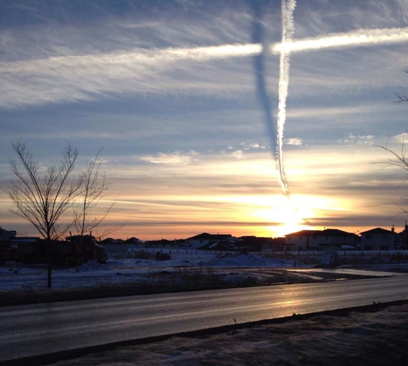
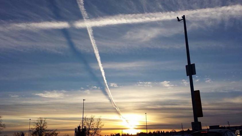
n the Calgary Skywatch FB page, Bob Currie wrote that he took his pictures (post #3) at 4:30 (11:30 UTC) at Deerfoot Mall, which is very close to the Calgary Airport (YYC) where the OP picture was taken. I have identified the location of one of his photos and modelled the crossing contrails on Google Earth:
10406672_10152802908540791_1531135905031502625_n.jpg

Calgary contrails SVM.jpg

The locations and direction of the two contrails are close to the DLH491 and AWE509 flight paths downloaded from FlightAware. Moreover, the trails of both planes can be brought to their modelled positions by the wind, the speed and direction of which can be deduced from the awailable data. Note that AWE509 flew near Calgary more than 10 minutes before DLH491 and his trail was moved by wind by some distance before it was crossed by the DLH491 trail.
Calgary contrails wind.jpg
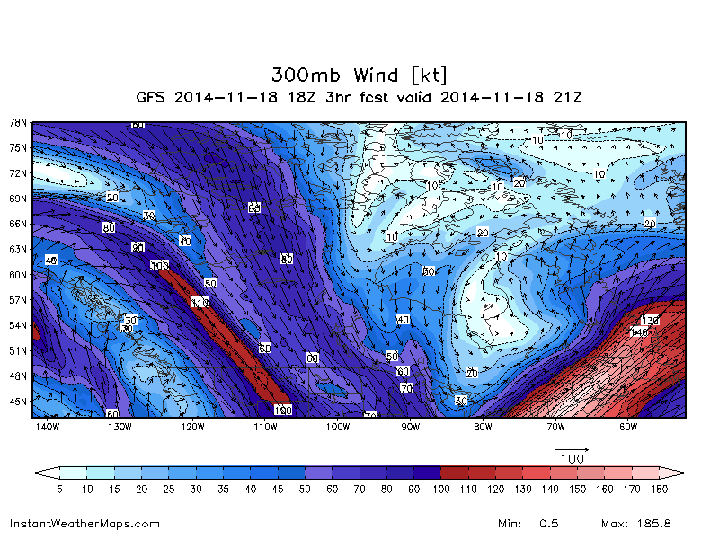
In this map, the yellow pins indicate the AWE509 and DHL491 positions at 11:10 UTC, whereas the other ends of their track segments indicate their positions at 10:55 UTC. The yellow line, representing the wind direction, connects the AWE509 position at 10:55 with the crossing position of modelled contrail at the estimated time of 11:30. The DLH491 crossed this line at about 11:10; it is the time than the crossing of the two trails was formed. The lengths of the two parts of yellow line are 13 and 18 nautical miles, respectively, and have about the same ratio, as the time intervals before and after the crossing formation (15 and 20 minutes, respectively). With the total length of 31 nautical miles and time of 35 minutes the estimated wind speed is about 55 kts. The estimated wind direction is 20°, or NNE. It is not as strong as the predicted speed of 79 kts and by 60° away from the predicted direction of 320° (see #7), but in a reasonable agreement with the forecast.

There is another agreement for these two planes. As can be seen in all photos, the 'vertical' (DHL491) trail casts shadow on the 'horizontal' one (AWE509), meaning that trails did not actually crossed each other and that the former was higher than the latter. Although both AWE509 and DHL491 were cruising at the same altitude of 37000 ft, at 10:55 AWE509 was still ascending, that can explain why its trail was lower at the 'crossing' point.

PS I have considered other contenders. There is no competition for the 'vertical' contrail but DHL491. For the 'horizontal' contrail the runner-up is UAL752 (Edmonton -> Denver). Its direction is closer to the direction of modelled trail than AWE509 heading. It passed Calgary further East at about 10:25, but its trail could have made to the modelled position with the wind blowing in the same NNE direction but stronger, with the speed of 65 kts. My subjective argument against it was that the 'horizontal' trail looks much younger than one hour.
 
Last edited:
You guys are amazing. Perhaps the "Trail" in front of your names is there for good reason? :p

I am a little bit confused on how you derived the wind direction and speed (especially as it pertains to AWE509), however. A 60 degree split just seems like a bit of a stretch, particularly as I look at 300 mb graph in post #8. I'm curious just from an inquisitive standpoint, as it is a little bit over my head right now ;).
 
Nice analysis. As you acknowledged, the GFS weather chart suggests the upper winds should have been from the northwest quadrant, not northeast, but I have my doubts about their accuracy. The model runs at pretty low resolution in the upper atmosphere, I believe.
 
You guys are amazing. Perhaps the "Trail" in front of your names is there for good reason? :p

My 'name' is a tribute to ContrailScience. It was Mick's fascinating analysis of the "mystery missile" contrail that prompted my interest to white lines in the sky.:cool:

I am a little bit confused on how you derived the wind direction and speed (especially as it pertains to AWE509), however. A 60 degree split just seems like a bit of a stretch, particularly as I look at 300 mb graph in post #8. I'm curious just from an inquisitive standpoint, as it is a little bit over my head right now ;).

The trails do not stay where where they have been laid by the planes but are moved by the wind. For simplicity, let's consider the high wind as a flow of a vast layer of air, the speed and direction of which remain constant across the whole layer and for a long period of time. In principle, the speed and direction can be deduced by determining the coordinates of particular (contrail) features embedded in this layer at different times. In this case, I have used the crossing point of the trails. (For illustration how the crossing points are formed and moved by the wind see Contrail Pattern Simulator).

With the defined flight tracks and timings it is a simple mathematical problem to find the wind direction and speed, if we know the position of the crossing point at given time. We are looking for a line going from the known crossing point and intersecting both tracks so that the distances between each intersection and the crossing point were proportional to the intervals between the times of each plane passing the intersection point on its track and the time of observation/photograph of the trail crossing. The wind speed will be equal to either of these distances divided by the corresponding time interval. Therefore, if the flights were identified correctly, this would have to be the wind parameters.

There are margins of error in my estimates of the contrail positions and orientation and the time of the photo, but they won't be able to change the calculated wind direction from NNE to NW. This would require a flight instead of AWE509 following a similar course to the west of Calgary, yet no suitable candidate could be found on FR24.

On the other hand, my runner-up for the 'horizontal' trail, UAL752, appears to suit better to this role than AWE509. It passed Calgary half an hour earlier and farther east, but was within the 'wind' range. Its course is almost parallel to the modelled trail, unlike AWE509, that has a 15° difference (my estimate of error margins for the modelled directions is less than 5°). Here is the derivation of wind parameters required for the UAL752 and DLH491 combination:
Calgary contrails wind #2.jpg
The orange line defines the wind direction. It connects the model trail crossing with the UAL752 position at 10:25 (distance: 66 nautical miles; time interval: 65 min) and intersects the DLH491 trail at 11:11 (distance: 20 nautical miles; time interval: 19 min). The calculated wind speed is 60 kts and the direction is again NNE (25°).
 
Last edited:
Back
Top