A cigar-shaped unidentified luminous object captured on a Xinjiang passenger aircraft [Likely Ski Area]

Sitreced the skislope. It does seem to fit even better. Nice one @Starflint ! i think thats a
1768479015608.png
{EDIT- this is wrong, see later posts}

https://www.metabunk.org/sitrec/?custom=https://sitrec.s3.us-west-2.amazonaws.com/15857/China Glowing Cigar/20260115_121537.js
1768479327867.png
 

Attachments

Last edited:
I'm uneasy about identifying this with a ski resort / bridge / pavilion, because it seems so unlikely that a single thing could be that brilliantly lit, yet there is no sign of a light at all on any approaching road. We are presented with miles of absolute darkness on the mountains, yet the object itself is brilliant and clear-cut. Is this likely?
 
If A is the silhouette of mountains against the sky, what is B?
Clouds.png


Alternative: We are looking at clouds backlit by the Moon. The lighter regions are thinner clouds, the darker regions are thicker clouds. A and B are thicker clouds.
 
Last edited:
If A is the silhouette of mountains against the sky, what is B?
I think that is clouds. Here's a levels-adjusted version of that pic. Based on the Sitrec recreations we would expect to see mountains where A is - the darker area here is mountain according to this interpretation. This is incorrect - see later posts The darker area at B looks like a gap in the clouds.

1768487697589.png
 
Last edited:

Do I have the co-ordinates wrong? It doesn't look like a match to me. It's the purple pin here, and I think there is a corresponding bright area in the pics from the plane. The mystery light is some way further left (north) - close to the bridge location, which is the yellow pin.

1768489099959.png
 
@Trailblazer hmmm. Sitrec says yes you're right. Urgh this is melting my brain! o_O

1768491103379.png


Aha - my error was that I didnt think the CBD & illuminated buildings were in the video. I thought the photos were after the video and therefore further along the flightpath. I assumed the CBD it was out to the right of this shot, which caused the perspective to be wrong. Schoolboy error! :rolleyes:
 
A question arises: if it were a large bridge, it would connect extremely long highways, meaning the highway streetlights would also be very long and not abruptly cut off in a short segment as seen in the video.
Is it possible we are seeing some sort of temporary lighting on the bridge? I am thinking possible construction/repairs being done at night. I am not sure what the practice is in China, in the US this (night construction/repair work) is pretty common and uses very bright lights.

delme.jpg


These "balloon lights" (not actual balloons but they look somewhat like them) are often used here, I don't know if Chinese construction companies use something different.

I wonder about temporary lighting as the bridge flarkey shows us above seems to lack much in the way of lights.
delme2.png

...though it may have inset decorative light s not visible in the picture. But this is why I wonder about some sort of temporary lighting.

Other temporary lights I can think of include stalled traffic (perhaps lined up unable to get past a traffic accident or other road closure) or the somewhat less likely temporary use of the bridge for a motion picture or television production location shoot.
 
Looking in the region of the bridge it is puzzling that we can't see more lights. Many of the buildings are actually down in the valley, though, and would be hidden from the POV of the plane. If it is not the bridge itself, could it be some of these buildings, just high enough up the side of the valley to peek out? It's odd that we cannot see any trace of that highway though!

1768491650925.png


Also, if this angle is roughly correct, the lights are "too high" to be the bridge, if you compare to where the putative ski area light is.

1768491793859.png


The fuzzy area of lights below the "UAP" roughly correlates with the area around the bridge. The mystery object itself looks more like it would align with the peak of the mountain behind!
 
This feature seems to be in the right location in front of the mountain, possible. Looks like just housing, but could it appear bright enough?

43.9599°N, 87.9946ºE

1768492320293.png


Green pin here:

1768492439785.png
 
This feature seems to be in the right location in front of the mountain, possible. Looks like just housing, but could it appear bright enough?

43.9599°N, 87.9946ºE

View attachment 87797


Green pin here:

View attachment 87798
I just used a very clumsy but straightforward method—using a ruler on the monitor screen to connect a point in the region you marked with different colors to that yellow point, thereby obtaining a path line with a certain degree of inclination. Then, I transferred the line onto the map, but each line ended up connecting to a different place. Later, I realized the reason was that I first needed to completely align the map's size and viewing angle height with several key points in the photographer's image to obtain the most accurate UAP point. I still haven't found it yet...
 
This feature seems to be in the right location in front of the mountain, possible. Looks like just housing, but could it appear bright enough?

43.9599°N, 87.9946ºE
I found the location information on Gaode Map; it is a government unit: 柏杨河乡独山子村劳动就业社会保障服务站(Baiyang River Township Dushanzi Village Labor Employment Social Security Service Station ), and it has working hours: Monday to Friday, holidays: 10 AM to 6 PM

To be honest, the nature and scale of this place don't seem capable of achieving bright lights (farther and brighter than a ski resort)

Gaode:https://www.amap.com/place/B0GK0M9A09

There are also some large industrial sites (coal mines and related plants, by the look of it) just beyond the mountain. It's hard to line up but is it possible that one of those might just be peeking out from behind the mountains? My Google Earth view suggests they should be hidden but I haven't put the flight elevation and location in yet.

1768494343834.png
 
There are also some large industrial sites (coal mines and related plants, by the look of it) just beyond the mountain. It's hard to line up but is it possible that one of those might just be peeking out from behind the mountains? My Google Earth view suggests they should be hidden but I haven't put the flight elevation and location in yet.

View attachment 87801
May need to check the flight data for the altitude around 21:45 and then compare it with the marked points in the picture; I'm not sure if we can see behind the mountain peak, but if possible, it's quite likely to be an entire town
 
Last edited:
May need to check the flight data for the altitude around 21:45 and then compare it with the marked points in the picture; I'm not sure if we can see behind the mountain peak, but if possible, it's quite likely to be an entire town

The view tallies with a time of about 21:47 at which point the plane was climbing through 12,000ft.

1768496194458.png


I put a placemark at 3650m absolute altitude and it looks pretty close:

1768496502384.png


Co-ordinates:

1768496700934.png


I tried the "show viewshed" option in Google Earth but it only seems to calculate a fairly small circle around the placemark.
 
Pretty sure this is the view in the first photo location in Ürümqi, looking East. Buildings are at 43.801758° 87.604875°.
1768404028857.png

This is looking east, right? Despite what the witness said about looking north.

compass.png

Just to the north of east, really. Say about 80 degrees.


And this is also looking east, right?

1768491793859.png


No one can find a convincing candidate for ground lights. The light is isolated, but if it were ground lights that would be improbable. The light doesn't show any sign of atmospheric extinction: It's just as bright as the city lights, although it would have to be much more distant. So how could it also be an electric light similar to the city lights? I've shown that the object is in the midst of light cloud cover. It's not below the horizon, it's above the horizon.

The Moon was rising in the east; azimuth 78 degrees (east-northeast) at the time.
About this direction:
compass.png


If the Moon were seen through very light clouds it would have a yellowish color cast. This light has a yellowish color cast.

I've shown a similar case in which the Moon, peeking through a gap in light clouds, was mistaken for a UFO.

C'mon.
 
Last edited:
The witness assumed that he was looking north because the ultimate destination was to the east. But the plane likely took off to the west-southwest. Then later made a slow turn to the east.


The engine in this view is clearly the port engine. The witness was looking out a window on the port side of the plane. Looking east during the turn while the plane was flying south.
no_reflection.jpg
 
Last edited:
If the Moon were seen through light clouds it would have a yellowish color cast. This light has a yellowish color cast.

I've shown a similar case in which the Moon, peeking through a gap in light clouds was mistaken for a UFO.

The moon was rising to the North East. Not behind the identified roads.

2026-01-15_19-47-36.jpg
 
The witness assumed that he was looking north because the ultimate destination was to the east. But the plane likely took off to the west-southwest. Then later made a slow turn to the east.


The engine in this view is clearly the port engine. The witness was looking out a window on the port side of the plane. Looking east during the turn while the plane was flying south.
从这个视角来看,发动机明显是左侧引擎。目击者当时正望向飞机左侧舷窗。在飞机向南飞行时的转弯过程中,目击者是朝东方向观察的。
View attachment 87820
1768544307409.png

1768544672543.png
 

Attachments

  • 1768544644390.png
    1768544644390.png
    635.4 KB · Views: 7
Last edited:
The moon was rising to the North East. Not behind the identified roads.

View attachment 87828
I don't understand the time as it's displayed in your screenshot. Does it say 11:36 UTC?

The time was 9:45 p.m. local time, which was 13:45 UTC. All of China is UTC +8. (China Standard Time, aka Beijing Time.)

In that region some people unofficially use "Xinjiang Time" which is UTC +6. The true geographic time zone. So local time would have been 7:45 p.m. Xinjiang Time. Which would also be 13:45 UTC. Wouldn't it?

To avoid confusion I set Stellarium to UTC +0 and entered the time as 13:45.
China Moon 104.png


The Moon's azimuth is 75.5 degrees. Roughly east-northeast. Which is different than the 78 degrees I got first time around. Although I think 78 degrees is more accurate because Stellarium adjusts to LMST if you leave it alone. (Even though I put in 19:45 p.m., I think Stellarium understands China Standard Time versus Xinjiang Time.)
 
I don't understand the time as it's displayed in your screenshot. Does it say 11:36 UTC?

The time was 9:45 p.m. local time, which was 13:45 UTC. All of China is UTC +8. (China Standard Time, aka Beijing Time.)
Yes, since you were suggesting a rising moon, I rewound until the moon was rising. All later times it is substantially above the horizon (and the mountains).

At 13:45 UTC, viewed from the plane, it's here.
2026-01-15_22-54-52.jpg

So I think we can safely say it's not the moon.
 
The witness assumed that he was looking north because the ultimate destination was to the east. But the plane likely took off to the west-southwest. Then later made a slow turn to the east.


The engine in this view is clearly the port engine. The witness was looking out a window on the port side of the plane. Looking east during the turn while the plane was flying south.
The plane was flying roughly southeast at the time (heading of 121 degrees). North is up in this view and the approximate location of the plane at the time of the video is marked near the middle.

The large yellow pin is the bridge identified by @flarkey which, although it seems it isn't the source of the light, is certainly in the correct approximate direction. So the camera was looking some way forward, roughly 50 degrees to the left, not at 90 degrees "sideways" out of the window.

1768550440996.png
 
Alright...

I've already been thinking of another alternative...

This case involved two aircraft with multiple landing lights in a row. C-130's.
https://www.metabunk.org/threads/amazing-ufos-in-marion-ohio-december-16-2021.12189/#post-262962


It's obviously not a C-130 but perhaps another plane with similar landing lights.

There were certainly other planes in that direction. The absence of any flashing lights made me discount planes initially.

1768551335841.png


Planes coming in to land at Urumqi would be in the correct general direction, and at a similar height to the filming plane (which is CES2300). At the time of my screenshot, GCR7524 was at about 13,500 feet, while the camera plane was at 12,000 feet.

I also noticed MNB300, which was following an almost parallel path to the filming plane, and so would likely appear fairly stationary. But it was at cruising height, 39,000ft, which seems much too high, and would not have landing lights on.

Time to play with Sitrec again...
 
Well well... that's certainly a coincidence! Flight 7524 seems to be in a very similar place to the UAP.

1768553883667.png


https://www.metabunk.org/sitrec/?custom=https://sitrec.s3.us-west-2.amazonaws.com/5177/Urumqi UAP/20260116_085812.js

My computer is struggling with Sitrec with the video import, so perhaps someone with some more modern hardware could do a proper video matchup.

The appearance of the object doesn't look very plane-like, and seems to be too big. Is it being blurred by the window and/or the camera somehow?

As always there is the question: if this isn't the plane, then why can't we see the plane as well?
 
Last edited:
So the camera was looking some way forward, roughly 50 degrees to the left, not at 90 degrees "sideways" out of the window.
I think that's correct, because the dark object at lower left looks like a seat in the row in front of the photographer. He claims he had the camera held flat against the window, but that seems incorrect at this point.
IMG_3538.jpeg
 
If that was true, you'd be seeing the whole window frame.
It's more likely that's the engine.
Yes I am sure it is the engine. I think the camera may be pressed against the inner window, but not perpendicular to the pane, so the view is somewhat forwards.

This seat map is from Delta but I think A321-200 seat plans are fairly standard. Seat 17A 18A looks the most likely.

1768570022662.png


Edit: putting numbers on it, the view azimuth given in Sitrec is about 68º (relative to north), and the flight was on a heading of 121º, so the camera was pointing about 53º to the left relative to the heading of the plane, or 37º off perpendicular.

Perhaps seat 18A is the closest candidate:

1768570568856.png
 
Last edited:
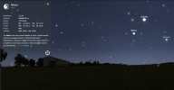
Correct: the bright object at top right is the moon, as confirmed in Sitrec.

View attachment 87845
It doesn't seem credible to me that the Moon could be that much brighter than the city lights. And the color temperature seems too blue. (But my knowledge of video photography is limited.)


But let's look at this (entirely different) video. What's going on here?


There are two lights, one brighter with a blue cast. One is dimmer with a yellow cast. It seems clear that the dimmer one is an internal reflection in the double paned window. There are also a number of dimmer lights, which seem to be tertiary (and so on) internal reflections.

Is the original light source:

- The Moon?

-The illuminating LED on the phone, which the naive videographer has left on/turned on.

To me the color temperature and the brightness says it's the LED on the phone. The person recording was trying to record the Moon, but all he captured was reflections of his own phone light.

But I'm willing to consider the possibility that this is the Moon, vastly overexposed.

There are also bright diffraction streaks. I'm guessing that airliner windows are made of acrylic plastic. Which explains the horizontal diffraction streaks as caused by micro-features put there during the manufacturing process. If I remember right it's because of the way acrylic is polished... in one direction. A tool that moves across the surface in one direction. The smaller diffraction streaks, at all angles, can be explained by random scratching/flaws.

The yellow cast of the dimmer light can be explained by the slightly yellow color of the acrylic plastic. As it's an internal reflection that's both dimmer and has had more chance to pick up the yellowish cast.


Now what could all this mean in our sighting?
 
Last edited:
Now what could all this mean in our sighting?
I think the one in the Chinese video is definitely the moon the location matches perfectly. Presumably the phone is in "night mode" as the city lights are relatively dim, so the moon is very overexposed.

Regarding the diffraction spikes... there is a horizontal diffraction spike, tilted slightly up to the right which is not too dissimilar to the orientation of the "cigar" UAP. But then there is a much brighter smear pointing downwards, which is totally absent in the cigar. But could the horizontal diffraction somehow account for the shape and size of the mystery light, turning the plane landing lights into a cigar shape?

1768579354676.png


Colour-wise, moonlight has a colour temperature of around 4100K, which is higher, i.e. bluer, than typical street lighting (around 3000K). A higher kelvin temperature counterintuitively means a "cooler" bluer colour.
 
delme.jpg


I think the second "thing" next to the very bright moon is the reflection of the moon bouncing around between pains of "glass" in the multi-plane window. As such, it is not as bright and so not obscured in glare and spikes and stuff. It would thus show the correct shape of the "thing," and something close to the correct size, visually.

To my eye, that looks about right for size and shape for the moon.
 
The red line is just one of the lines of sight from the aircraft to the 'luminous cigar'. It doesnt map to a feature on the ground.

I've tried to illustrate my geolocation rationale here. I think there are some new buildings in the city that aren't shown on the GoogleEarth imagery. The city of Urumqi looks beautiful. Amazing to think that such an urban metropolis exists in the absolute middle of nowhere,

View attachment 87747

(edit, hang on that blue line feature is wrong)
I'm not entirely sure if our initial map search correctly identified the landmarks, which in turn affected our determination of the exact UAP location. I've found some aerial footage from flights that passed directly over Ürümqi, which could potentially be used for a detailed comparison.


https://www.xiaohongshu.com/explore...BKaDHCnYyvNLq6EqGhRy5WsER7C8-fBQDFW6d-EwAlF4=
1768587198459.png


https://www.douyin.com/video/7459300979649957172
1768587123619.png

Other Perspectives
 
Back
Top