Interesting clouds [Row of fallstreak clouds]

cloudspotter

Senior Member.
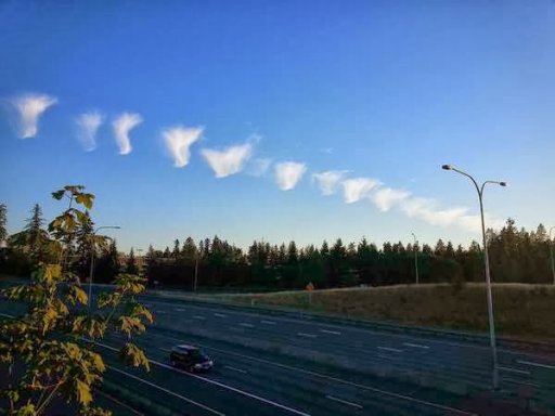
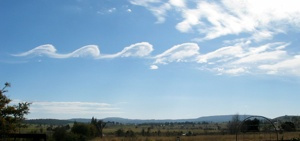
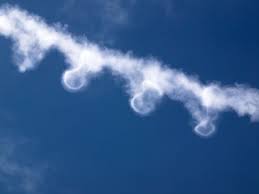
This jellyfish train has been photographed over Seattle. I guess it could be the remains of a contrail pendules since they are so regularly spaced. What does everyone else think?

odd.jpg
 
Cliff Mass from the UW in Seattle explains...

So we had an area aloft that was near saturation and the moisture from the jet engines pushed it over to saturation...giving a contrail. The atmosphere aloft was close enough to instability that small cirrocumulus elements developed and subsequently precipitated.

On the meteorological Richter scale this might be a 1, but it is an interesting diversion on the beautiful summer night.
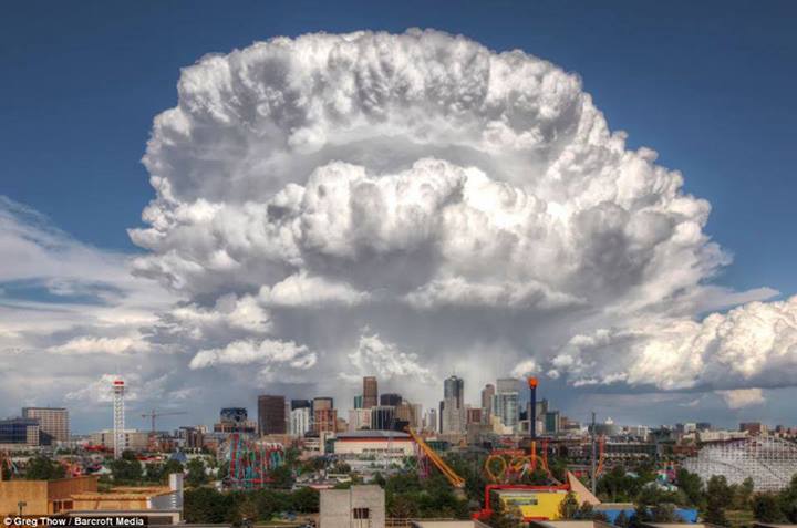
Content from External Source
http://cliffmass.blogspot.com/2013/08/stange-clouds-sighted-over-western.html (http://archive.today/Z1q4C)

It looks like a N-W contrail or two may have been the trigger for a perpendicular line of clouds along an E-W line of atmospheric instability. I wonder if turbulence from wing tip vortices could have been a factor as well.
 
Last edited by a moderator:
http://www.truthcontrol.com/forum/chembombsthe-new-chemtrails

Geo-Enginneering Chemtrails,Are Now the New Geo-Engineering Chem-Bombs! The US Patent 747 Tanker is used to spread the Aerosol into the atmoshere to change the course of Isaac over Central America,and Colombia,South America! So it is now headed in a north-westerly course ,and is now headed for the coast line of the Gulf states in the USA! Huge Exploding Balls of Swirling Spikes are shown from the Satellite Modis in sector 7,which is over Northern coastal South- America. Our weather around the world, is, and has been modified according By The NWo=Disorder! These are also Suspected in Foul play Connected to the Exploding Fires Widely Seen in the Middle to theWestern United States of America,Though the Guise of The Evergreen Program.This program is being used to Spread Aerosol above these fires,to create more exploding Outbreaks of Fires in other areas! They are being incouraged to increase,and to spread over larger land masses to Deplete our Air Quality! This has been happening for a long time now.These fires,and black smoke can be seen from space,by our Satillites! And Guess by whom? Right! The NWo=Disorder
Content from External Source
 
Last edited by a moderator:
Not sure if this is a *thing* or not...
As the sun came up this morning it seemed to affect the clouds with virga that weren't there before, or at least couldn't be seen because of the angle. I suspect it was the light changing the temperature in the clouds.
This was over ten minutes.
IMAG0489.jpg IMAG0493.jpg
IMAG0494.jpg IMAG0496.jpg
IMAG0498.jpg IMAG0502.jpg
 
Last edited by a moderator:
I think the virga are there in all the photos, it's just the lighting changes. The sun is basically becoming edge on to the cloud layer, and the more acute the angle the more detail is revealed. It's like shining a flashlight along a bumpy wall.
 
These are not as interesting as some pictures here, but I liked seeing the various layers of them. If I kept up with them, I was driving, some of them may have started out as contrails. The picture was taken on I20 about halfway between Midland and Dallas.
 

Attachments

  • edcloud2WTX.jpg
    edcloud2WTX.jpg
    26.1 KB · Views: 700
  • edcloudWTX.jpg
    edcloudWTX.jpg
    19.6 KB · Views: 668
Geez I'll try but I am in no way an expert.
Um, the sky is made of regions of moving gas, of different densities and pressures and temperatures. These interact and act on each other. Where these regions are made visible through frozen water vapour some of these interactions are observable. (clouds)
Sometimes these interactions are chaotic and other times they have a relative symmetry.
Know I'm just totally guessing here, but I would say the line of clouds represents a dense layer of air, and there is another layer with more energy pushing up through it, kind of 'washing away' around the clouds. It might not necessarily have been a contrail, it could have been a naturally formed long cloud, but it has been eroded by the air pushing on it.
The landscape under it would likely have some influence as well.
Ever seen water shift sand into patterns? Sort of like that, but not.

Sorry I can't be more specific than that. You'll have to wait for someone who knows a bit more about it to tell you.
 
Last edited:
Geez I'll try but I am in no way an expert.
Um, the sky is made of regions of moving gas, of different densities and pressures and temperatures. These interact and act on each other. Where these regions are made visible through frozen water vapour some of these interactions are observable. (clouds)
Sometimes these interactions are chaotic and other times they have a relative symmetry.
Know I'm just totally guessing here but I would say the line of clouds represents a dense layer of air, and there is another layer with more energy pushing up through it, kind of 'washing away' around the clouds. It might not necessarily have been a contrail, it could have been a naturally formed long cloud, but it has been eroded by the air pushing on it.
The landscape under it would likely have some influence as well.
Ever seen water shift sand into patterns? Sort of like that, but not.

Sorry I can't be more specific than that. You'll have to wait for someone who knows a bit more about it to tell you.
Ok Ill wait for the real CON..trail experts to finish coming up with an answer and scientific evidence on this one.
 
Similar to a kelvin helmholtz cloud.

but yours looks lower and is probably in the midst of dissipating.
It looks a bit mare's tail-ish too.
 
Looks to me more like Awacs on Awacs off Daniel son.

As mentioned above, what is your understanding of the terms "Awacs" (as you spelled it)?

Sounds as if you are pronouncing it as "a-wax"? And thinking of an old TV commercial for a floor product:
"Wax On, Wax Off" was their slogan.

EDIT: Oh, it was later an iconic 'Karate Kid' movie reference!!! Hilarious:


But, THAT movie got it from a 1970s TV commercial!!! :)


In any case, the actual acronym 'AWACS' (you can look it up) is indeed pronounced "a-wax", just for ease of communication usually, when discussing it.

But, this is in no way pertinent to contrails.

Your photo shows a situation where there was likely some strong mountain wave airflow activity.


An airplane flying through that will experience turbulence, depending on various factors....AND its contrail can appear intermittent. Later, after the airplane has passed, the contrail fragments are undergoing more "stress" from the prevailing air currents.
 
It’s hardly likely the ambient temperature and humidity uniformly varied where the plane traveled.
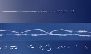
I'm not sure what you are referring to here, but relative humidity varies as much as clouds vary. The visibility of a cloud is essentially a measure of the relative humidity in that parcel of air going above the threshold for condensation. Or as this 1894 book on clouds puts it:

"[Clouds are] portions of the atmosphere which, from natural causes, have become temporarily visible"
- Cloudland, W. Clement Ley, 1894

So in all the hugely varied ways that the boundaries and repetitions of clouds can vary, so can the invisible areas of higher and lower relative humidity.
 
I have missed the first discussion of this interesting phenomenon and now have done my own research into it. My conclusion is that the formation of a row of fallstreak clouds most likely has not been caused by a contrail or triggered by a passing plane after all, but it "was purely meteorological in origin".

There are three 'new' lines of evidence for this.

1. The line of clouds was formed at a relatively low altitude of about 20,000 ft.
2. The line was perfectly aligned with the wind; it remained in essentially the same spatial position while clouds were moving along it from the west to the east.
3. W-E commercial flights in this location are rare and none was recorded on flightradar24 at the time.

I will elaborate on these tomorrow, it is past midnight here.
 
What? Where? When?
To figure out what was the row of clouds in the picture attached by Zane (#16) I firstly tried to find where and when it was observed. Fortunately, there is a copy of this picture with EXIF data with the date and time and, in the title, the name of the city where it had been taken. It took me a while to find the camera location at a road junction near Redmond, WA (47°39'15.34"N 122° 8'13.43"W) that placed the cloud row somewhere over Seattle.

At this point M Bornong (#27) posted the link to previous discussion, from which I found my 'what' was the same phenomenon that happened in a big city and left plenty of photographic evidence. Having searched flickr, I have found quite a few photos from different viewpoints with readily identifiable camera locations. I've used them to model the row of clouds on Google Earth:
Redmond road junction.jpg Space Needle Seattle.jpg

In all used photos, the row of clouds aligns well with the same line passing from West to East just north of the SeaTac Airport at the altitude of about 7 km (23 000 ft):
Cloud train line.jpg

It was surprising because the photos were taken at different times. This means that the row of clouds did not move laterally. Contrails usually do, as they rarely are aligned so perfectly with the wind direction.

At this point I have paid more attention to the Cliff Mass Weather Blog and found there is a NOAA weather satellite image at 7 PM with a line of clouds in essentially the same location and orientation as my model line. This gave a high confidence to the altitude value determined by this approach. There was one thing, however. Fitting the webcam images from the blog to Google Earth showed that my model aligns with the earlier trail, not with the second one that was thought to produce the row of clouds. Fortunately, in the blog comments there was a link to a time lapse movie from this webcam for that day, August 6, 2013. It showed the evolution of these trails for longer. After the bits and pieces of the second trail went out of the frame or disappeared, along the line of the first trail arrived familiar clouds of the same shapes and sizes as seen on the other photographs taken at about the same time:
UW Atm Sci webcam.jpg

The movie also revealed that both trails were at the same altitude and moved parallel to each other with the same speed. This is supported by another photo that I found this morning:
9456080096_9bc8dc792c_o.jpg
It is geotagged to a location near the SeaTac Airport right under the modelled line.

The webcam recorded the evolution of these trails into the row of fallstreaks clouds at one end. Snapshots of its evolution in other parts can also be seen on photos, for example:
9459924434_2a3a96cc91_o.jpg9688148717_d0175799e2_o.jpg
Note, that in two hours between the two snapshots, the cloud shapes changed but their line remained in the same place.


The movie provides no support to the hypothesis of these trails being originated from contrails or triggered by passing planes. On the contrary, the progressions of the tips of these trails were not gradual, unlike occasional contrails in the same movie.

Given its relatively low altitude and perfect alignment with the direction of wind, the formation of a row of fallstreak clouds the most likely "was purely meteorological in origin".
 
Last edited:
Back
Top