

A sighting yesterday, reported on Twitter, with ATC recording:
Source: https://x.com/Shauns_Aviation/status/2097394430500376701?s=20
The flight number EI3931 and position puts the incident at around 1715 UTC (18:15 local time) on September 8. The plane involved was an Aer Lingus Regional ATR 72-600, EI-FAT, flying from Newquay to Dublin (callsign EAI71G).
The ATC recording from 1700-1730 UTC (attached) shows that the clip here is from 1718UTC, with the initial report to ATC came at 17:18:16 UTC, but the conversation refers to details that aren't audible on the recording, so there must have been some other communication previously.
Transcript (I think the Twitter clip had the first line incorrect)
EI3931: Very close, a drone. A drone almost beside us on the left side.
ATC: OK, just confirming, you were at 6,000 feet?
EI3931: Yes
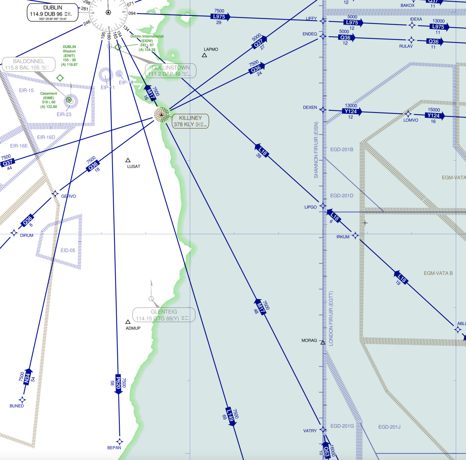
ATC: It was ten miles from LAPMO*, you said?
EI3931: Ten miles to LAPMO, at 6,000, a drone, for us, on the left side.
ATC: OK, thank you. Any distinguishing marks or anything that we can pass on?
EI3931: It was just black, that's it.
ATC: And you would describe it as quite large, is that correct?
EI3931: Yes.
ATC: OK, we'll pass it on, thanks for the report.
A minute later, ATC speak to another Aer Lingus flight, EI495 (callsign EIN49D) which is on approach to land and was off to the left of EI3931 at the time of the sighting, to see if they saw anything. They didn't.
(17:19:22)
ATC: Shamrock Four Nine Delta, you were about eight to nine miles west of the track of that Gemstone** that he's just reported that. You didn't see anything off your right hand side?
EI495: Negative, sir, Four Nine Delta.
Then they speak to EI3931 again
(17:20:04)
ATC: Gemstone Seven One Golf, have you any idea how close that drone was to you, in terms of distance or altitude?
EI3931: The drone was the same altitude, about 6,000 feet, and let's say... [pause] two miles, maximum. On the left.
ATC: Same altitude, understood, thank you.
I haven't found any more communication with the plane that sighted it, but ATC then mentioned it to a later flight, Ryanair FR5307 (RYR6FH).
(17:28:32)
ATC: Ryanair Six Foxtrot Hotel, just be advised, we've a recent report of what appeared to be quite a large black drone, about ten miles southeast of LAPMO, a bearing of about 160 from LAPMO, so pretty much a direct track from VATRY* to LAPMO, ten miles from LAPMO itself. Ryanair craft reported as he passed through 6,000 feet.
(17:29:19)
ATC: ...miles west of the reported location of that drone and there was no observed primary radar target at any point.
*LAPMO is a waypoint over the sea east-southeast of Dublin airport. VATRY is another waypoint further south.
** Gemstone is the callsign for Aer Lingus Regional flights operated by Emerald Airlines
I think there's quite a strong possibility that the "drone" was actually the other Aer Lingus flight, which was ahead and to the left of the plane that reported the sighting. It also made a sharp turn to the left at almost exactly the location mentioned (10 miles south from LAPMO).
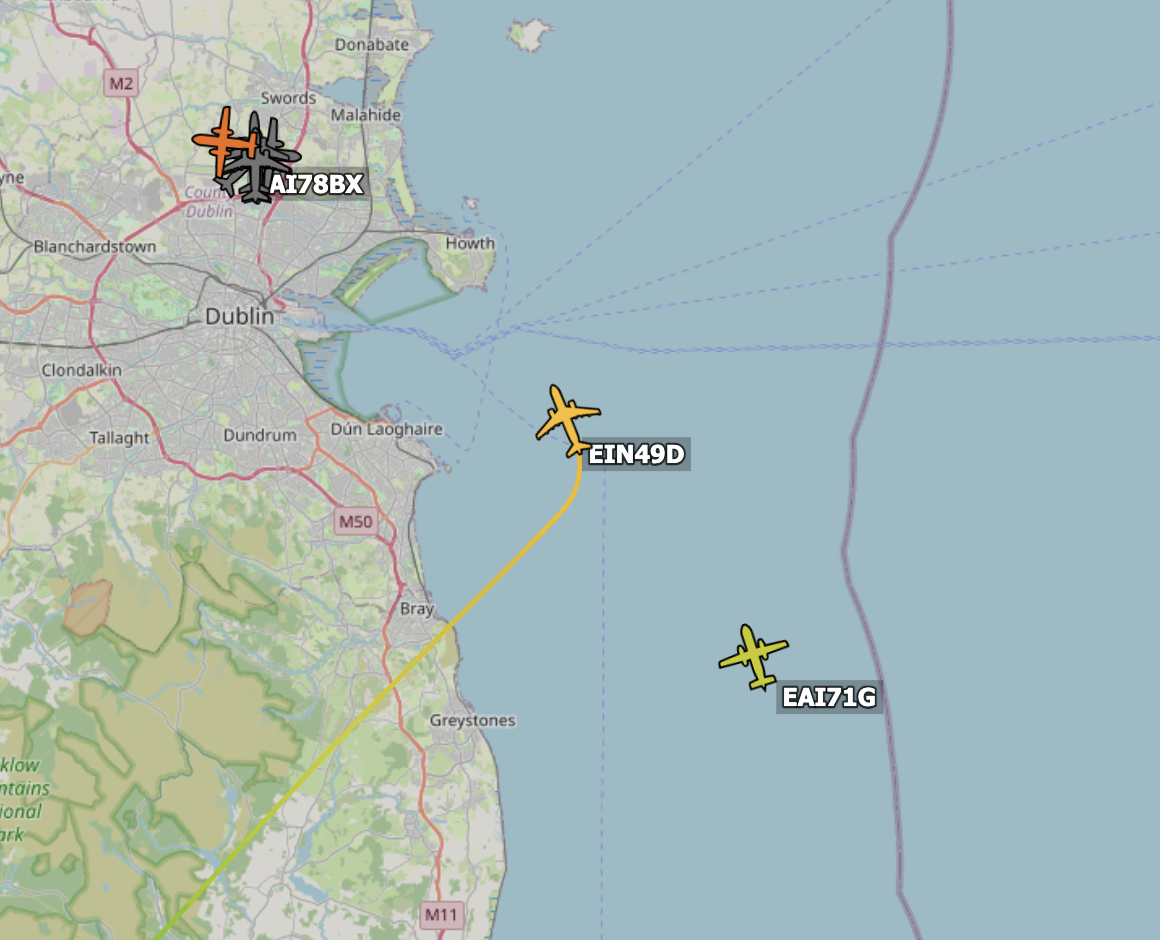
However, at the time it made this turn it was at about 4,000ft, while the witness plane was at about 6,500ft. Both planes were descending, but throughout the sighting period, EIN49D was about 2500-3000ft lower than EAI71G, which does not tie up with the report of being at the same altitude.
I put the tracks into Sitrec and the plane does appear to be tracking alongside to the left when viewed from the witness cockpit. I am having trouble exporting a video but here is a link: https://www.metabunk.org/sitrec/?custom=5177/Dublin drone/20260909_103502_8122565c1169f7b636a1f00dccd8a4da.js
Also, the plane seems hard to mistake for a "black drone", being mostly white, although the sun would have been behind it at this time of day. Recent photo from July 2026:
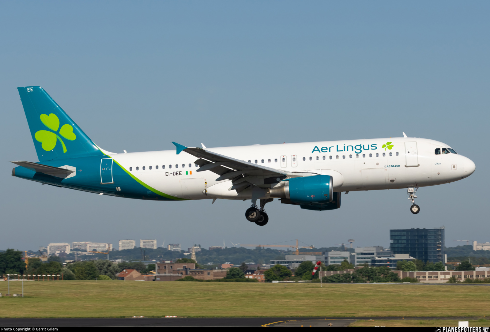
Possibly the dark tail section could be seen as a mystery black object, if the white body of the plane was lost against the background?
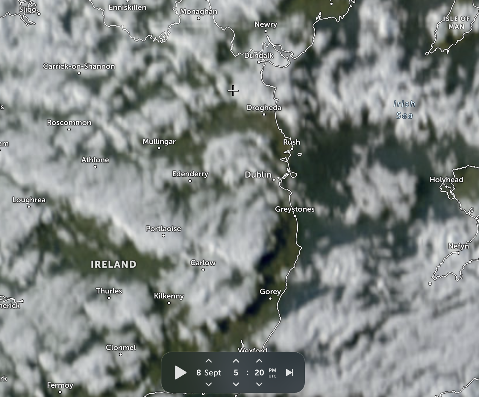
Satellite image shows broken cloud over the area in question:
Source: https://x.com/Shauns_Aviation/status/2097394430500376701?s=20
The flight number EI3931 and position puts the incident at around 1715 UTC (18:15 local time) on September 8. The plane involved was an Aer Lingus Regional ATR 72-600, EI-FAT, flying from Newquay to Dublin (callsign EAI71G).
The ATC recording from 1700-1730 UTC (attached) shows that the clip here is from 1718UTC, with the initial report to ATC came at 17:18:16 UTC, but the conversation refers to details that aren't audible on the recording, so there must have been some other communication previously.
Transcript (I think the Twitter clip had the first line incorrect)
EI3931: Very close, a drone. A drone almost beside us on the left side.
ATC: OK, just confirming, you were at 6,000 feet?
EI3931: Yes
ATC: It was ten miles from LAPMO*, you said?
EI3931: Ten miles to LAPMO, at 6,000, a drone, for us, on the left side.
ATC: OK, thank you. Any distinguishing marks or anything that we can pass on?
EI3931: It was just black, that's it.
ATC: And you would describe it as quite large, is that correct?
EI3931: Yes.
ATC: OK, we'll pass it on, thanks for the report.
A minute later, ATC speak to another Aer Lingus flight, EI495 (callsign EIN49D) which is on approach to land and was off to the left of EI3931 at the time of the sighting, to see if they saw anything. They didn't.
(17:19:22)
ATC: Shamrock Four Nine Delta, you were about eight to nine miles west of the track of that Gemstone** that he's just reported that. You didn't see anything off your right hand side?
EI495: Negative, sir, Four Nine Delta.
Then they speak to EI3931 again
(17:20:04)
ATC: Gemstone Seven One Golf, have you any idea how close that drone was to you, in terms of distance or altitude?
EI3931: The drone was the same altitude, about 6,000 feet, and let's say... [pause] two miles, maximum. On the left.
ATC: Same altitude, understood, thank you.
I haven't found any more communication with the plane that sighted it, but ATC then mentioned it to a later flight, Ryanair FR5307 (RYR6FH).
(17:28:32)
ATC: Ryanair Six Foxtrot Hotel, just be advised, we've a recent report of what appeared to be quite a large black drone, about ten miles southeast of LAPMO, a bearing of about 160 from LAPMO, so pretty much a direct track from VATRY* to LAPMO, ten miles from LAPMO itself. Ryanair craft reported as he passed through 6,000 feet.
(17:29:19)
ATC: ...miles west of the reported location of that drone and there was no observed primary radar target at any point.
*LAPMO is a waypoint over the sea east-southeast of Dublin airport. VATRY is another waypoint further south.
** Gemstone is the callsign for Aer Lingus Regional flights operated by Emerald Airlines
What was the drone?
I think there's quite a strong possibility that the "drone" was actually the other Aer Lingus flight, which was ahead and to the left of the plane that reported the sighting. It also made a sharp turn to the left at almost exactly the location mentioned (10 miles south from LAPMO).
However, at the time it made this turn it was at about 4,000ft, while the witness plane was at about 6,500ft. Both planes were descending, but throughout the sighting period, EIN49D was about 2500-3000ft lower than EAI71G, which does not tie up with the report of being at the same altitude.
I put the tracks into Sitrec and the plane does appear to be tracking alongside to the left when viewed from the witness cockpit. I am having trouble exporting a video but here is a link: https://www.metabunk.org/sitrec/?custom=5177/Dublin drone/20260909_103502_8122565c1169f7b636a1f00dccd8a4da.js
Also, the plane seems hard to mistake for a "black drone", being mostly white, although the sun would have been behind it at this time of day. Recent photo from July 2026:
Possibly the dark tail section could be seen as a mystery black object, if the white body of the plane was lost against the background?
Satellite image shows broken cloud over the area in question:


