John Massaria latest video.

Pointing out terminological inexactitudes is perfectly fine. That's just part of debunking.

I'm not being polite to spare people's feelings. I'm doing it because I think it works better. And unfortunately it's not going to work if I'm polite, but other are not.

Like I said, I know this rankles somewhat. But this is how it's going to be. Let's try it for a year and see what happens.
 
The bulk of the video is suggesting that TMA is used in jet fuel, and does not combust until it is past the gap despite the fact that TMA is highly reactive to oxygen, and there is no way it can get through the combustion chamber without combusting. In fact, it would most likely blow up the plane - that's if there was any way to even get it into the fuel in the first place.
I don't think so. All kerosine takes up water. The freezing of this water during a flight through a particularly cold stratosphere caused a blockage which forced an Airbus to land short and wreck itself at Heathrow a couple of years ago.

TMA reacts spontaneously with water too. You would have to desiccate the fuel completely. In the video scenario mentioned, the material was tanked separately and fed to a spray ring in the afterburner of a fighter to propel it at Mach 3 and 98,000 feet altitude.

This is a useful material if you want to intercept a high-flying bomber from ground level in a non-stealth (!) mode, because you will certainly frighten the bomber pilot. But you really might not return with an intact plane.

This isn't just an excess of kerosene. It's liquid thermite. A fuel/air bomb made of this would be quite like a tiny nuke.
 
I don't think so. All kerosine takes up water. The freezing of this water during a flight through a particularly cold stratosphere caused a blockage which forced a British Airways Boeing 777 to land short and wreck itself at Heathrow a couple of years ago. TMA reacts spontaneously with water too. You would have to desiccate the fuel completely. In the video scenario mentioned, the material was tanked separately and fed to a spray ring in the afterburner of a Lockheed SR-71 surveillance aircraft to ignite the afterburner which would then propel it at Mach 3.2 and 85,000 feet altitude.
A couple of minor corrections in bold for you there.
 
A couple of minor corrections in bold for you there.
Doublesize would help too. :)

It was a Rolls Royce fuel system so I guessed where my memory failed. The other stuff had been paraphrased already. Confused by boron hydride research in the sixties... the list goes on and on.

The proposition (TMA being burned by passenger.transport jets) is so totally off the ball*.

It makes me very sad every time*.

Wonder Warthog at your service**.

* Warmer rather than cooler.

** For the old comic collectors and literati, that indicates doubleplus ungood. I need an empty room to scream into.
 
... and I forgot - the stuff used in the SR-71 is TEB, or Tetra-ethyl borane. They carry enough on-board for something like 20 afterburner ignitions, after that runs out they have platinum elements in the burner ring that glow hot enough to ignite the afterburner fuel but as far as I understand it, the ignition isn't always symmetrical so it's not used unless they have no choice.
</useless trivia>
 
<useless trivial opinion>
I don't think that flight ventured into the stratosphere.

http://en.wikipedia.org/wiki/British_Airways_Flight_38
The flight was from Beijing Capital International Airport to London Heathrow Airport.
That route took it over Mongolia, Siberia and Scandinavia, at an altitude which varied between 34,800' and 40,000' (FL348-400, between 10,600 m and 12,200 m), and in temperatures between -65 and -74 °C. I very much doubt altitude range is within the stratosphere over those latitudes (north from Beijing).

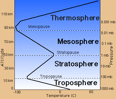
The other clue is that the stratosphere is typically not cold. The air temperature decreases to the tropopause then remains more or less the same, or increases again as you continue up in to the stratosphere. The tropopause is the coldest level below the stratopause (~50 km high).
layers.gif

Airliners seldom fly in the stratosphere... at or near the tropopause, but seldom above it. Usually it's above "coffin corner", so they're not going there.
</useless trivial opinion>
 
Grrr. I didn't want to spread into detail right then. I just meant "up".

The most notable point is that that temperature minimum is normally -40 deg C, but can, on occasion, be -80 deg C.

This extreme cold is its own "coffin corner", having frozen out the hydraulic rudder actuators on Boeing 737s, killing hundreds before the problem was found.

And water is present in fuel, so TMA could only be admixed if all water were to be removed.

Apart from that, I need my glasses to find my glasses. :)
 
I don't think so. All kerosine takes up water. The freezing of this water during a flight through a particularly cold stratosphere caused a blockage which forced an Airbus to land short and wreck itself at Heathrow a couple of years ago.

Just one correction to your statement...stratosphere should be troposphere.
Here is the info on the crash...http://en.m.wikipedia.org/wiki/British_Airways_Flight_38

Sorry didn't see the previous post
 
Its my understanding that due to the tropopause and resulting temperature rise, a good majority of commercial aircraft if not all commercial aircraft will not penetrate the tropopause, it wouldn't be worth the extra fuel burn.
I know I have never, and I fly at fl410 in Canada in January.
But I could be wrong.

Flying just above the tropopause would not be much different, temperature wise, than flying just below it. What would consider to be "penetrating the tropopause"?

There was some debate on this here:
https://www.metabunk.org/threads/928-Contrails-in-the-Stratosphere

Most contrails form in the troposphere.
 
Last edited:
http://en.m.wikipedia.org/wiki/Tropopause#section_1

Commercial jets stay in the troposphere as a result in the decreased laps rate or possibly increasing temperature. In addition, the jet stream becomes less apparent, thus, the turbulent eddies created from that transition jeopardizes aerodynamic stability. The aerodynamics of a jet in the upper troposphere gets very unstable and entering a zone of increasing temperature would be very dangerous and unpredictable. That's why we are fully aware of the proverbial coffin corner. I've been in hairy situations trying to top springtime thunderstorms.

I see your troposphere, and raise you a stratosphere :)

http://en.wikipedia.org/wiki/Stratosphere
Commercial airliners typically cruise at altitudes of 9–12 km (30,000–39,000 ft) in temperate latitudes (in the lower reaches of the stratosphere)
Content from External Source
 
Yeah that wiki is not correct. The jet stream lies within the troposphere. Did you look at my link? It has the correct picture.

I am flying from DFW-MSP Delta flight 3411 departs at 2315z. Our planned altitude is fl370 and I guarantee you we will be in the troposphere and we will be making contrails...at least in the state of Texas and Oklahoma.

Let me add that your link has the correct altitudes with regard to jet travel but the stratosphere quote is not.

I'm not trying to be awkward here, but how will you know you are in the troposphere? What are you using to detect it? "the lowest level at which the lapse rate decreases to 2°C/km or less,"?

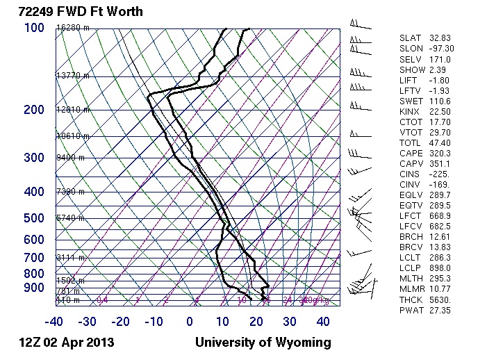
Here's the Forth Worth 12Z sounding. Where's the tropopause?
http://weather.uwyo.edu/cgi-bin/sou...AR=2013&MONTH=04&FROM=0212&TO=0212&STNM=72249


13000m? FL420?
 
Last edited:
Approx. 42,000 feet is where the tropopause resides according to the sounding from April 2 at 1am central.
Ill respond more later tonight. Right now I just finished a 4-day trip and I'm driving 200 miles home:)
 
I'm not trying to be awkward here, but how will you know you are in the troposphere? What are you using to detect it? "the lowest level at which the lapse rate decreases to 2°C/km or less,"?

Here's the Forth Worth 12Z sounding. Where's the tropopause?
http://weather.uwyo.edu/cgi-bin/sou...AR=2013&MONTH=04&FROM=0212&TO=0212&STNM=72249


13000m? FL420?

Excerpt from the text format of that particular sounding, from NOAA. Level 7 indicates Tropopause Level, which I've highlighted. Measurement is in meters.

Format: Level / Pressure / Height / Temp / Dew Point / Wind Direction / Wind Speed

6 1126 15544 99999 99999 270 65
5 1020 16145 -661 -721 99999 99999
7 1020 16145 -661 -721 280 60
4 1000 16280 -651 -721 280 61
6 793 17678 99999 99999 295 35
5 774 17828 -673 -733 99999 99999

Tropopause location as measured by the radiosonde was at 102 mb, at 16145 meters (52,969 feet), with a temperature of -66.1 and dew point of -72.1 (both in Celcius), with winds out of the west at 60 knots.
 
Last edited by a moderator:
1 AM central? 12Z is 7 AM central.

I had a good laugh at myself after this mistake. I was in a big hurry to catch the shuttle bus off the airport, looking forward to a 4-hour drive home...not!! I use Z time every day at work...ha ha, and I know I'm not in...umm...Hawaii?
 
I'm not trying to be awkward here, but how will you know you are in the troposphere? What are you using to detect it? "the lowest level at which the lapse rate decreases to 2°C/km or less,"?

Here's the Forth Worth 12Z sounding. Where's the tropopause?
http://weather.uwyo.edu/cgi-bin/sounding?region=naconf&TYPE=TEXT%3ALIST&YEAR=2013&MONTH=04&FROM=0212&TO=0212&STNM=72249


13000m? FL420?


I don't really worry about determining the tropopause, we never get close to it "most of the time". We rely a lot on our dispatch to compile NOAA data and determine the best cruise altitude based on turbulence, temperature, winds aloft...it's mostly computerized these days. However, it still involves human interaction as sometimes the flight plan software will file us for FL400 for a 40 minute flight...NO WAY!!!

If I was to worry about where the tropopause was I'd look for how the jet stream was behaving based on our assent, where the clouds stop during assent, and the differential pressure gradient which is calculated through our flight management system, and how the OAT is behaving. IMO, those would be the best indicators. If I've forgotten something or if someone has a better way aside from sounding data, chime in.

I am curious if we are on agreement about the troposphere and the elevations/layer of atmosphere commercial aircraft fly??

I took some cool pictures of contrails while we were flying. We were at FL370 and we were IMC most of the way. Lots of cirrostratus and lots of contrails. I'd like to know how to post them to the site.

BTW, I'm a newbie here, I joined not only to debunk chemtrail believers but I really want to relearn about meteorology. I'm very rusty at it.
 
Last edited by a moderator:
I am curious if we are on agreement about the troposphere and the elevations/layer of atmosphere commercial aircraft fly?
The height of the troposphere is known to be variable. The troposphere is itself oblate, with maxima around 45,000 to 55,000 feet at the equator, and minima 18,000 to 23,000 feet at the poles. The 777 that crashed at Heathrow (that was a tough break) had flown over the North Pole, I think, through an air temperature of -80 deg C.

I took some cool pictures of contrails while we were flying. We were at FL370 and we were IMC most of the way. Lots of cirrostratus and lots of contrails. I'd like to know how to post them to the site.

selecttask.png

selectfile.png

upload.png

BTW, I'm a newbie here, I joined not only to debunk chemtrail believers but I really want to relearn about meteorology. I'm very rusty at it.
Well, it's a big, big, world. Make yourself at home. :)
 
The height of the troposphere is known to be variable. The troposphere is itself oblate, with maxima around 45,000 to 55,000 feet at the equator, and minima 18,000 to 23,000 feet at the poles. The 777 that crashed at Heathrow (that was a tough break) had flown over the North Pole, I think, through an air temperature of -80 deg C.


selecttask.png

selectfile.png

upload.png


Well, it's a big, big, world. Make yourself at home. :)

Jazzy, thanks for the info. The next stupid question is where should I post the pictures? Can I post videos? Sorry if this seems simple, I've never done it.

Regarding the layers of atmosphere...This part of the thread began when you said Stratosphere and in my little world that is a big deal as airliners don't fly in that layer as that is reserved for the SR-71, shuttle, rockets, maybe a rawindsonde, and a few others.

I wanted to mention about a flight I had last spring, May I think. It was DCA-MSN (Washington DC-Madison, WI), at night. We were at FL410, We observed an ambient temperature reading of -86 degrees C, highly unusual. There must have been something up with the fuel additives in addition to the Rolles Royce heat exchanger. Just a curious comment that's all.

Here is an interesting article about the crash, which you probably already know about.
http://www.aviationtoday.com/regions/usa/66569.html#.UVy7E5OTzSg
 
Nice video. Flying through a contrail gives a great perspective, we normally think of contrails as "spreading out" but really they are mostly "spreading down" after the initial expansion. When you look at it from the ground this can lead to some confusion.
 
Well, since you brought it up...This is a contrail at 39,000 feet from my flight yesterday. It spread horizontally/laterally, it isn't clear in this picture but that is what we observed. It was an interesting day of weather.

IMG_0626[1].JPG
 
If you look at the contrail it is going up and down. The aircraft is flying at a constant altitude. I think over time the contrail will spread more laterally.
 
Ha Ha, no. I'm not laughing at you. I have never been sick on an airplane (lucky). I've been through some rocky stuff. The bump was the wake of the leading aircraft. It was only about 10 miles in front of us. Which is proper separation at those altitudes.


Cool video- thanks!

It looked as if there was bump as you passed through it...was there?


Oh- and did you feel sick afterward? :)
 
Looks like a cousin of my Global in that video. But you need this cockpit in it to make it better:
 

Attachments

  • image.jpg
    image.jpg
    80 KB · Views: 423
No worries...

I ask because some "chemtrail" Believers say they can taste "chemtrails" after they have been "sprayed" whilst others claim to feel sick and see illness around them after "spraying"- to see someone fly right through it without any repercussions is noteworthy- or should be.

How long does the wake last- how many miles behind until you do not feel it any? ...and does the wake spread out like a boat on a lake?

wineandflyguy?

The wake is basically up to the wingtip vorticies, and if the plane is leaving a contrail the contrail gets entrained in the vortices, so the size of the contrail should give an indication of the size of the wake.

There will also (I imagine) be ripples in the air, that propagate sideways like the V shape of a boat, but that's a different type of thing

 
Last edited:
That is fantastic!

Are you able to tell what the relevant atmospheric conditions are when you're flying along (outside temp/humidity)?

To be honest, I took this vid on a whim. I thought at the last second "this is cool" grabbed my iphone and took it. I didn't really think about recording SAT or TAT. or winds aloft.
 
Your point is very valid and makes me think. Have you watched a boat with a wake make a white line in the water behind it? It's the white-wash of the prop leaving a white line. Perfect example.


The wake is basically up to the wingtip vorticies, and if the plane is leaving a contrail the contrail gets entrained in the vortices, so the size of the contrail should give an indication of the size of the wake.

There will also (I imagine) be ripples in the air, that propagate sideways like the V shape of a boat, but that's a different type of thing

 
Last edited by a moderator:
Back
Top