Solved: PVS-14 Night Vision Pilot's Footage of "Racetrack" Flares [Starlink]

DaveG

Member
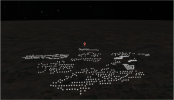
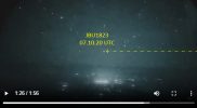
Another video was taken somewhere in the US; the person wants to remain anonymous, so the date and time are not given. The plane was said to be at 34,000 feet and filmed using a PVS-14 Gen 3 white phosphorus night vision scope through an iPhone. The constellation is in the direction of Cassiopeia, and judging by the alignment, it is probably around 2:45 a.m.


Source: https://www.youtube.com/watch?v=RP03_sN4ZmM
 
Last edited by a moderator:
It would be nice to sync this video up with satellites.
Very hard to do without a date & location. We might be able to estimate this by cross-referencing the elevation of Cassiopeia above the horizon, and the direction of the sun to just to the right of Cassiopeia. Comparing historical cloud coverage over continental USA at these times might give an estimate of location and perhaps flight number. The only feature in the video I can see that would give an indication of location are the flashing lights at 1m20s which I assume is a large wind turbine farm, like this...


Source: https://www.youtube.com/watch?v=fybhQAc6xKQ
 
Last edited:
Yes, it is very difficult without the right location and exact time. I too was wondering about those lights in a grid pattern, if it is a wind farm, it would narrow down the locations. I also tried matching up satellites going in the opposite direction (right to left or top to bottom) without success. At least we now have a date.
 
Yes, it is very difficult without the right location and exact time. I too was wondering about those lights in a grid pattern, if it is a wind farm, it would narrow down the locations. I also tried matching up satellites going in the opposite direction (right to left or top to bottom) without success. At least we now have a date.
This is a great video. It shows just how dynamic that the Starlink flares can be.

Just some initial thoughts and analysis....

1. We know that this video was taken over the USA.
2. We know the upper limit of starlink satellites orbit is around 53 degrees,
3. We know that Starlink flares occur at about a distance of 2000km between the satellite & observer.
4. That means the plane was flying east above the southern states of the USA.

1682409366195.png

From the video we can identify the Constellation Cassiopeia, which when viewed from the southern USA states gets into that position at around 2.30am local time, as just as @DaveG suggested in post #61 above. We can also see that the area of most intense flares is to the right and slightly below Cassiopeia, and this matched up with the expected azimuth and elevation of the sun.

1682409712830.png

Assuming the date of 18 April is also correct, we can correlate the thunderstorms seen in the video with the weather history.

https://www.blitzortung.org/en/historical_maps.php?map=30

This shows that the only thunderstorms over the southern states of CONUS were in Northern Oklahoma.

1682410969793.png

Regarding the flashing lights and the wind turbines, every single turbine is shown on this map. It will be hard to cross reference the patterns seen in the video with the map.

1682416295030.png

https://eerscmap.usgs.gov/uswtdb/viewer/#8.24/36.328/-99.167
1682411551671.png


Anyway, here's the in-the-sky plot for Tulsa at around 2.30am local on 18 April 2023. It shows that there were indeed Starlink satellites in the right area of the sky , with the correct sun-position conditions to generate flares.

1682411761408.png
1682411779091.png
 
Last edited:
Update:

Going back to the image of the 'flashing lights', it appears that in the video there two types of flashing light - a lot that are synchronised with a flash rate of abut 0.5 Hz (after accounting for the sped up video at 4x normal speed) , and another set collection of unsynchronised flashing lights. The latter of these reminded me of the UAP report from Texas that turned out to be center-pivot irrigation systems. Oklahoma has many of this in the west of the state, and they are along side a wind farm near the town of Guymon.

https://eerscmap.usgs.gov/uswtdb/viewer/#9.14/36.3237/-101.4765
1682425082488.png

Using overpass-turbo I searched the area for 'wind turbine' and downloaded the KML for it (attached). This allowed me to view the position of the wind turbines in 3d and adjust for perspective.

1682427575353.png


This is a comparison of a still from the video and a screenshot of the kml in google earth adjusted for perspective.

1682427455811.png


I can change the view in Google Earth to appear to be night time so the lights appear as , well, lights. I've also added a few 'blackout' areas for local cloud cover.


I think thats a match for the shapes in the foreground.
 

Attachments

  • export.kml
    529.8 KB · Views: 131
  • 1682425320122.png
    1682425320122.png
    380.3 KB · Views: 103
I'm having trouble wrapping my head around one aspect of the video DaveG posted in post 61 above. Some of the satellites appear to be moving at different speeds. A notable example is at 3:18 in -- click here for cued link. Of the three satellites circled in this picture, two of them appear to be pulling away from the third at higher speed.
Capture.JPG
My undersdtanding is that the whole lot of them are at essentially the same altitude, and so should be moving at essentially the same speed. Might the slower satellite be something other than Starlink, at a higher/slower orbit? But if so, it seems a striking coincidence that it would flare at the same time, unless the difference in geometry is less than I am imagining. Or is it a perspective effect with the slower satellite moving at more of an angle away from the camera?

It's not vital, and these "raetrack" UFOs are pretty clearly established as Starlink flares, but I am curious and if anybody has an answer I'd appreciate it.
 
It's not vital, and these "racetrack" UFOs are pretty clearly established as Starlink flares, but I am curious and if anybody has an answer I'd appreciate it.
Yeah, I see what you mean. The way I rationalise this is that the satellites may be at same (similar) altitude but at a different distance away from the observer. Our depth perception is confused by the point source of light they they appear as - so your brain thinks they are all the same distance away. Equally, a brighter light makes you think it is close when it could be further away and reflecting more light.

This interactive map shows that they are not all at the same altitude. Most are around the 550km altitude, but they vary between 540km and 580km

https://satellitemap.space/

1682435176601.png

Getting back to the video, I think the plane that it was taken from was one of these, but cant narrow it down any further. I've tried to align the time that they passed Guymon with the satellite position form In-the-sky.org but its too difficult.

1682438117562.png
 
Last edited:
Most are around the 550km altitude, but they vary between 540km and 580km
Thanks, that is helpful in regards to distances. (Even if it is wrong, I feel better now! ):D

And it makes sense that there is some variation from the "ideal" 550km altitude -- I had not expected it to be that much.
 
Flarkey, nice work finding the windfarm! I put in the coordinates for Borger, Texas, into Stellarium based on the flight tracks but haven't yet managed to line up any satellites. I was hoping to pin down one particular satellite going from right to left that appears at 2:48 in the video. One candidate I found is CZ-2C R/B and shows up at 3:35. Stellarium seems to match the video better at this time, as opposed to 2:30, when the constellation is right on the horizon.
 
Flarkey, nice work finding the windfarm! I put in the coordinates for Borger, Texas, into Stellarium based on the flight tracks but haven't yet managed to line up any satellites. I was hoping to pin down one particular satellite going from right to left that appears at 2:48 in the video. One candidate I found is CZ-2C R/B and shows up at 3:35. Stellarium seems to match the video better at this time, as opposed to 2:30, when the constellation is right on the horizon.
Yeah, tried to do the same in Stellarium last night with the orbital data from the 18th and using the other aircraft that can be seen in the video cross referenced in FlightRadar24 to give a time but without luck.

I've also tried to stabilise the first part of the video hoping that it might help with the alignment process.


There's 2 planes flying right-to-left across the video and at the 1m28s mark they line up - I think these are JBU1823 and ATN3311 - they line up on ADSB exchange Playback too, and the 3d model in Google Earth fits too.....

1682503919984.png


1682504159138.png

Google Earth
1682504138069.png

That suggests that the 1m26s mark in the video = 07.10:30 UTC , I think.

EDIT.... there's another trio of planes that seems to fit the satellite flare position at T = 7.46UTC. will check it against Stellarium.

1682520150107.png
 

Attachments

  • StarlinkTLE18APr23.txt
    1.5 MB · Views: 88
  • 1682500422878.png
    1682500422878.png
    152 KB · Views: 89
  • 1682500471286.png
    1682500471286.png
    384 KB · Views: 79
Last edited:
Exactly! I’ve heard so many mentions of “racetrack” UAPs I searched trying to find them. The 7 minute video further down is the best, and seems to show 2 sets of likely Starlinks moving in different directions, plus a couple planes, and likely another satellite or 2. It sounds to me like when pilots see a few moving lights going from dim, to bright, then dim again, over & over again, they assume it’s the same lights flying in circles, with landing lights only visible when pointed towards them. I have yet to see any video of something actually flying in circles.

I’ve seen Starlike trains in close formation, and some that were maybe closer to being on station, with approximately 20 seconds between them passing a given point / star, once 2 strings crossing paths, but non were flaring. Once I was outside waiting for the ISS to appear, staring at the point above west horizon where I expected it. Saw a very bright flash lasting several seconds, then gone. I assumed that was ISS but it showed up right on schedule a few minutes later in the exact same spot. I’m convinced that was a flaring satellite or possibly a ship approaching or leaving the ISS.
 
There's 2 planes flying right-to-left across the video and at the 1m28s mark they line up - I think these are JBU1823 and ATN3311 - they line up on ADSB exchange Playback too, and the 3d model in Google Earth fits too.....
Every single one of the "oh wow!"s that we hear accompanying these videos should be bestowed upon your good self.

It seems that people who live in a country where (allegedly) 90% of the population have no passport are amazed that the 1950s technology we've been flinging absolutely everywhere is absolutely everywhere.

Now, hopefully, people can begin to understand the complaints from the observatories.
 
Can one of our more graphically talented members please create an "I'm not saying it's Starlink ... but it's Starlink" meme?

Here's a view of the sky at the suspected date and time of the 'UAP fleet' video. I Haven't manged to do a full synchronisation, but the movement of the lights seen in the video match for speed, direction and overall pattern.

1682678840517.png

and just for @FatPhil ...
Ancient Aliens 28042023084559.jpg
 
Last edited:
The Oklahoma video is now getting some traction on Twitter and Reddit....


Source: https://twitter.com/TheProjectUnity/status/1653079272226013202?s=20


Source: https://www.reddit.com/r/UFOs/comments/134v20z/recorded_at_34000ft_using_pvs14_gen_iii_night/

I have been able to simulate the pattern of the lights in Stellarium, but havent been able to fully sync the video with the simulation yet. Although the OP has said the video is from 18 April, I'm not totally convinced. Peeople often get the date of night-flights or videos recored after midnight wrong. The visibility of lightning so far west in Oklahoma makes me think that this is actually the morning of th 19th April, at arounf 0800UTC time going by the position of the stars.


Last edited:
Here's my rationale for my belief that the video is from approx 8AM on the 19 April

1682966079607.png

https://www.blitzortung.org/en/historical_maps.php?map=30

Looking NNE from Guymon OK at 8am UTC on 18 April
1682966098394.png

Looking NNE from Guymon OK at 8am UTC on 19 April
1682966119250.png

Edit, after thinking about this i realise it could be a number of days that have different lightning patterns, not just the 19th.
 

Attachments

  • 1682966149064.png
    1682966149064.png
    318.1 KB · Views: 88
Last edited:
I'm having trouble wrapping my head around one aspect of the video DaveG posted in post 61 above. Some of the satellites appear to be moving at different speeds. A notable example is at 3:18 in -- click here for cued link. Of the three satellites circled in this picture, two of them appear to be pulling away from the third at higher speed.
Capture.JPG
My undersdtanding is that the whole lot of them are at essentially the same altitude, and so should be moving at essentially the same speed. Might the slower satellite be something other than Starlink, at a higher/slower orbit? But if so, it seems a striking coincidence that it would flare at the same time, unless the difference in geometry is less than I am imagining. Or is it a perspective effect with the slower satellite moving at more of an angle away from the camera?

It's not vital, and these "raetrack" UFOs are pretty clearly established as Starlink flares, but I am curious and if anybody has an answer I'd appreciate it.
I noticed that, and wondered (excuse my ignorance about the behavior of starlink satellites) if it could be two different strings intersecting from that viewpoint.
 
Here's my rationale for my belief that the video is from approx 8AM on the 19 April

1682966079607.png

https://www.blitzortung.org/en/historical_maps.php?map=30

Looking NNE from Guymon OK at 8am UTC on 18 April
1682966098394.png

I too thought the lightning storm was too far east, and the air traffic seemed a bit too congested as well. If the plane had taken off from Las Vegas, it would probably have been the 18th, right? I'll have another look at the ADSB replay for the 19th.

By the way, I don't know how you keep your composure and answer informatively and respectfully to that guy on his YouTube channel. Words may not convince people, but your Stellarium visualisation might. You should post that on his channel.
 
@flarkey, what's the current best guess at time?

I'll need:
  1. KLM of the source plane
  2. Approx Lat/Lon for loading the landscape
  3. Suspected start time of the video
  4. Appropriate TLE file
 
A very rough first pass. I got the TLE, figured a rough static position and a time from the thread
https://www.metabunk.org/sitrec/?sitch=pvs14

Code:
videoSpeed: 4,
files: {
    starLink: "./Starlink-PVS14.txt",
},
fps: 29.97,
frames: (7*60+14)*29.97,
startTime: "2023-04-18T07:46:26.000Z",
terrain: {lat: 36.3237, lon: -101.4765, zoom: 8, nTiles: 8},
ptz: {az: -24.8, el: 3.7, fov: 27.7, showGUI: true},
 
@flarkey, what's the current best guess at time?

I'll need:
  1. KLM of the source plane
  2. Approx Lat/Lon for loading the landscape
  3. Suspected start time of the video
  4. Appropriate TLE file

I'll see if I can confirm the plane - best guess was N321DH (possible KMLs are attached)
The TLEs are in the post #14 above: https://www.metabunk.org/attachments/starlinktle18apr23-txt.58838/
Lat and longs are also in the kml that confirms the windfarm in post #8: https://www.metabunk.org/attachments/export-kml.58812/


I think sychronising the video is going to be difficult because 1) we don't have a 1x speed version of the video, and 2) we don't have an accurate time of the start of the video - but the best guess we have is 18 April at around 0745UTC.
 

Attachments

  • N236FR-N376DN-N481MC-track-press_alt_uncorrected.kml
    155.4 KB · Views: 45
Last edited:
It's probably better to have sitrec play the satellites at 4x, slowing the video by 4x is doable but it will generate interpolated frames.
 
I've been trying to sync this up for the last few days, with no luck. I thought that I should just check that the TLEs are right, and the sitrec software is plotting them right ... and I think they are.

This is a comparison between in-the-sky.org and @Mick West' sitrec graphics. All the Starlink Sats are in the right spot at the right time.
1695913684945.png

Just need to narrow down the start time. The crossing of the two planes at the 1m25s mark is something we should be able to match to the ADSB records, but I'm really struggling to find an exact match.
 
Last edited:
Looking at the flashes of the Windfarm lights at 1m20s in the video - which in reality are 1 Hz but are about 4 Hz in the video - I think it is x4.
Hmm, looks like I was wrong here. I think the speed of the video is closer to x5.

Play the OP video at 0.25 speed (which , if at x4 speed would put it back to real-time) and compare the windfarm lights flashing in the foreground with the Windfarm lights in the second one at normal speed.


Source: https://youtu.be/RP03_sN4ZmM?t=88


Source: https://youtu.be/fybhQAc6xKQ?t=1

The lights in the first video appear to be faster than 1 Hz when viewed in the 'realtime' speed. @Mick West - can the simulation 'replay-time-speed-multiplication-factor' (?!) be an adjustable parameter in sitrec?
 
Last edited:
The lights in the first video appear to be faster than 1 Hz when viewed in the 'realtime' speed. @Mick West - can the simulation 'replay-time-speed-multiplication-factor' (?!) be an adjustable parameter in sitrec?

Under "Tweaks" the "simSpeed" parameter now adjusts how fast the sim plays. (just in PVS14, for now)
 
I've been trying to sync this up for the last few days, with no luck. I thought that I should just check that the TLEs are right, and the sitrec software is plotting them right ... and I think they are.

This is a comparison between in-the-sky.org and @Mick West' sitrec graphics. All the Starlink Sats are in the right spot at the right time.
Hmm, the KMLs you gave are for April 19, but the time we are working for for satellites is April 18
 
Hmm, the KMLs you gave are for April 19, but the time we are working for for satellites is April 18
I checked this this other day too. The TLE syntax uses the day of the year to identify the validity , which in the file I submitted is 23106 & 23107 for days 106 & 107, which is 16 & 17 May 2023. So that should be ok.

0 STARLINK-1007
1 44713U 19074A 23106.69198129 .00004441 00000-0 31732-3 0 9999
2 44713 53.0522 256.1497 0001304 108.8599 251.2532 15.06343001189450
0 STARLINK-1007
1 44713U 19074A 23106.69198129 .00004441 00000-0 31732-3 0 9999
2 44713 53.0522 256.1497 0001304 108.8599 251.2532 15.06343001189281
0 STARLINK-1007
1 44713U 19074A 23107.42181764 .00033595 00000-0 22646-2 0 9993
2 44713 53.0525

I had tried to sync the video against times on 19 & 20 May using the same TLE and that was the reason why I checked it against in-the-sky.org for the expected time in post #35. And although I didn't post it I did compare them for 20 May and they were pretty close.
 
I checked this this other day too. The TLE syntax uses the day of the year to identify the validity , which in the file I submitted is 23106 & 23107 for days 106 & 107, which is 16 & 17 May 2023. So that should be ok.
The TLE isn't the problem. I'm just not sure what actual date to use. It was set to April 18, but the KML tracks for the planes is on the 19th
 
Back
Top