Square Cornered Clouds

J

Joe

Guest

Attachments

  • DSCF7463.JPG
    DSCF7463.JPG
    139.1 KB · Views: 482
Last edited by a moderator:
Where and when exactly was this taken @Joe? Wondering if it was at all related to this: http://www.reddit.com/r/aviation/comments/2v2gqb/crazy_square_cloud_i_saw_today/
Vero Beach . Northeast of the Lake Okeechobee (The Big Lake )

What date/time?
Not sure around the 21st of Jan ? afternoon , pretty sure we had a cold front come in on that day .http://lance-modis.eosdis.nasa.gov/imagery/subsets/?subset=USA8.2015021.aqua.1km
 
Last edited by a moderator:
DSCF7464.JPG Looking east over the Atlantic last week
Where and when exactly was this taken @Joe? Wondering if it was at all related to this: http://www.reddit.com/r/aviation/comments/2v2gqb/crazy_square_cloud_i_saw_today/
Which was located in a satellite image here: https://www.metabunk.org/data/MetaMirrorCache/6e3cdb3985f85d0de1587fb8720017d8.jpg


Here is a permalink to the comment on reddit that refers to this image: http://www.reddit.com/r/aviation/comments/2v2gqb/crazy_square_cloud_i_saw_today/coeh1c9

Joe's image is "looking east over the Atlantic", whereas the reddit image is on the Louisiana coast, Gulf of Mexico.
 
Are any of these claims true?

yes.

"Scientists have put forth forward hypotheses about the causes of square clouds"
they have. https://www.metabunk.org/explained-flying-carpet-rhombus-shaped-cloud-in-exeter.t4122/


"Clouds strange shape bean to appear frequently around the world."
too ambiguous a statement. began when? Define frequently.

"Information about clouds square shape began to appear in 2008"
again, I don't know what this statement means. Does he mean scientific explanations or .. people only started seeing them in 2008?
This guy remembers them in the 1960s
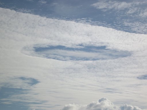
In elementary school once they showed us a movie (a cause for excitement in the 1960s) about weather and storms. One brief section made an impression which stuck vividly in my memory. (Admittedly, a vivid memory is not necessarily an accurate memory! Meteorologists out there can tell me if I'm off my rocker here. Maybe even somebody knows this exact film.) The narrator mentioned that hail storms often come from oddly shaped clouds. Then the film showed a stormy-looking sky and the narrator said, "This square-shaped cloud brought a very destructive hail storm to (such-and-such mid-western state)." A square cloud, eh? How weird. http://www.donaldsauter.com/the-most.htm
Content from External Source
"Mark steer data: "
he has it pinned now.
https://twitter.com/steermark?lang=en
CmkTjw-UcAA49Uy.jpg
 
Are any of these claims true?
I'd try to focus on evidence, rather than claims. Claims without evidence can generally be ignored.

Most of the "square" clouds that people post about are just a corner, with fairly straight lines, and a fairly well defined corner (quite rare for it to be actually 90°).

The "cloud" on the left here appears to be fake.
HAARP-Cloud-936146.jpg

The cloud on the right was discussed above:
https://www.metabunk.org/posts/143775/
 
I saw this from the train this morning in west London. Not a square cloud but a square-edged hole in the clouds. At least one edge appeared to be formed by a contrail. I couldn't get great photos due to the direction the train was travelling, and the reflections on the windows.

06F570C3-867A-498D-8A7F-F99A5370C26B.jpeg B28A3CB8-2FE4-493E-A060-C9872438013E.jpeg


Looking at the photos I’ve been just noticed another less defined square “hole” which seems to be formed from a contrail grid, above the one I was focusing on:
B1D10BCD-2789-40FC-87A3-11FAE02CC99B.jpeg


Satellite image from today - some time later than my photos. Lots of contrails among the cloud. This might be the same hole, having drifted northeast with the wind?

upload_2019-2-6_13-10-23.png
 
Hi guys,

The photos you posted are mind blowing!

I was sent this photo + exif data by a friend of mine who was driving towards Davenport, Fl:

28768142_1466738876781318_1624803872_o.jpg


28768399_1466738870114652_137477728_o.png 28695092_1466738993447973_902251018_o.png


Cheers,
Chris
 
Hi guys,

The photos you posted are mind blowing!

I was sent this photo + exif data by a friend of mine who was driving towards Davenport, Fl:

28768142_1466738876781318_1624803872_o.jpg


28768399_1466738870114652_137477728_o.png 28695092_1466738993447973_902251018_o.png


Cheers,
Chris

That one’s an interesting one, albeit with a different cause than the others in the thread. I suspect that cloud is the result of the Lifted Condensation Level (the height at which air lifted from the surface cools enough for clouds to form) occurring just a few thousand feet below a strong cap (a layer of stable air that acts as a lid on weaker updrafts), which would trap the visible cloud column between two relatively flat surfaces.

I wouldn’t be at all surprised to find that cloud sits atop an updraft with an anthropogenic source, like a smokestack, which would increase the humidity as well as provide lift, and explain its isolated nature.
 
Last edited:
Back
Top