What's the Farthest Distance a Contrail is Visible at?

But you set FOV of 1.86° (no digital zoom) and got about the same fit as I did in the first attempt above (#62). I have reproduced your fit, the trail is still about twice higher than the track.

Perhaps it was a secret sprayer deployed to thwart you record attempt by flying parallel to UAE205 and closer to your location ;)
Or there was an atmospheric refraction lifting up the trail appearance by a small fraction of one degree…

It should be higher than the track. Something like 0 .1 degrees for the conversion from barometric altitude to geometric, and something like 0.25 degrees for refraction (like sun).
 
It should be higher than the track. Something like 0 .1 degrees for the conversion from barometric altitude to geometric, and something like 0.25 degrees for refraction (like sun).
My final fit of your record contrail photo (horizontal FOV 1.73° (full optical zoom only), the same location as your fitting attempt, 50 metres above sea level):
UAE205 contrail.jpg
The contrail is higher than the track by only about 0.23°. The right end of the thicker segment of the track is the location of the plane at about the same time as the time of the photo.
 
Hoping to catch some nice sunlit contrails today (I didn't :rolleyes: ) I noticed one which may be a candidate for this thread though with so much traffic up there I have no idea if ID'd the correct one.

I present my "evidence" poor as it may be, in the hope the more skilled can confirm or deny my best guess. Please :)

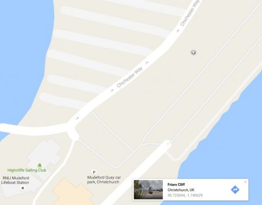
According to google maps, this was my viewing point https://www.google.co.uk/maps/@50.7248305,-1.7406561,19.01z

AAGeo.JPG


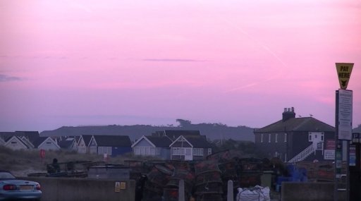
Looking SSW (appx 210° according to my compass app) This is the earliest capture of the contrail timestamped 16:03 chosen due to the obvious change in heading and resultant curved trail.

AA1703.JPG


Here is a wider-angle view zoomed out taken at 16:05 which shows approximate elevation

AA1705.JPG


And although not shown in this screengrab, zoomed in I could still see the trail being laid some moments later.

AA1705b.JPG


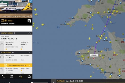
Using Flight Radar 24 playback, I notice MON64 make a left turn at 15:55 just off the French coast of Paimpol.

AAMon64.JPG

If this is indeed the same flight, that puts it appx 200 miles away?
 
Last edited:
And yes, it goes over the horizon at 200 miles.
20161205-104644-i3in4.jpg

20161205-104833-z40y0.jpg

However in your image it goes behind cloud around 160-180 miles.
 
That's Hengistbury head in the way.
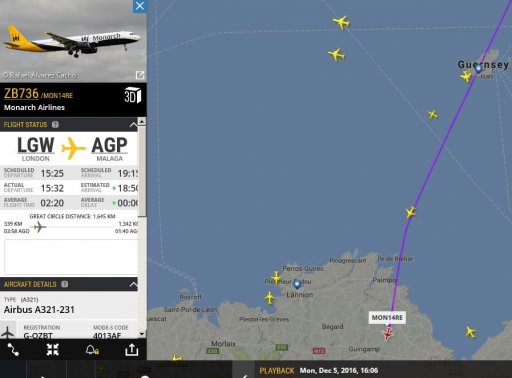
There is another candidate (now I've realised my camera was 1min 22secs slow) MON14RE which also does a left turn at 16:02

AAMon14RE.JPG

I've attached the original video.
 

Attachments

  • ContrailDistance.mp4
    8.9 MB · Views: 797
Last edited:
That's Hengistbury head in the way.
There is another candidate (now I've realised my camera was 1min 22secs slow) MON14RE which also does a left turn at 16:02

AAMon14RE.JPG

I've attached the original video.
Yes, this is the right one:
Monarch 736 contrail.jpg
I did not bother to optimise the photo fit on the foreground, but the background and the contrail match quite well. The end of the thick segment of the track is the aircraft position at 16:05.

PS The plane at the time was about 150 miles away.
 
Last edited:
In which case RAM803 would be the other following contrail parallel up to the point of the left turn (also at 16:06)? Best seen on the video.
 
PS The plane at the time was about 150 miles away.

Google maps was more generous at 160miles at the point the two contrails stopped being parallel (filmed). I'm sure it was still visible for a minute or so more afterward but I'll settle for 150 for first attempt :cool:
 
Last edited:
Hey guys. Fascinating thread - some great pictures and analysis. As someone who enjoys flying and plane watching, Flightradar24 has quickly become one of the most utilised apps on my phone! Like many posters on here I've always wondered 'just how far is that plane?' Thankfully now we know! With my app to hand and a watchful eye on the sky, below is a collection of photos that I've taken of planes at long distance with contrails. All photos were taken on an iPhone 6.

On some photos you may need to zoom or tilt the screen slightly to get a better view of the contrail.

IMG_7777.JPG
Taken from the A110 near Oakwood (north London) overlooking Trent Park. The camera is facing west. Unfortunately I've misplaced the Flightradar screenshot but the hook of the contrail is over Gloucestershire.

New.jpg

The contrail (circled) is over Llandovery in the Brecon Beacons which is approximately 160 miles away. This photo was taken at 19:37 on Monday 15 August 2016. If anyone can track down further info that would be great.

IMG_9440.JPG

Taken from Oakleigh Park Station (north London) at 09:03 on Friday 25 November. The plane was passing over Sandwich Bay which is approximately 72 miles away. I tracked the plane for another 10 miles until it dropped behind the tree line.

IMG_9441.PNG

Flightradar info for the plane passing over Sandwich Bay.

1new.png
Taken from the railway bridge at New Barnet Station at 09:33 on Friday 25 November 2016. The camera is facing east/south east. The visibility was phenomenal. Interestingly, Barnet is on high ground and there isn't anything much higher between Barnet and the Urals on the Eastern borders of Russia. The contrail of the plane (circled) was passing over Dunkirk in northern France which is approximately 118 miles away. I managed to track this flight for another 30 miles but the camera was simply not good enough.

IMG_9447.PNG

Flightradar info for the flight passing over Dunkirk.

IMG_9681.JPG

Nice and easy. Taken from Putney Bridge Underground Station on a crisp Autumn morning. The furthest plane is approx 37 miles away.

IMG_9682.PNG

Both planes are on exactly the same flight path.
 
Last edited:
All photos were taken on an iPhone 6.

On some photos you may need to zoom or tilt the screen slightly to get a better view of the contrail.

IMG_7777.JPG
Taken from the A110 near Oakwood (north London) overlooking Trent Park. The camera is facing west. Unfortunately I've misplaced the Flightradar screenshot but the hook of the contrail is over Gloucestershire.

New.jpg

The contrail (circled) is over Llandovery in the Brecon Beacons which is approximately 160 miles away. This photo was taken at 19:37 on Monday 15 August 2016. If anyone can track down further info that would be great.

Underneath the hooked contrail there is another one that probably was even further. The other plane was heading in an opposite direction getting closer. Planefinder.net playback suggests the hooked trail was ELY11 and the other one was EIN556:
Screen Shot 2016-12-13 at 11.45.26.png

Luckily, the KML files of both tracks for the date are still available from FlightAware (attached). When looked on Google Earth from the camera location, they match the contrails quite well:
ELY11&EI556 contrails .jpg
The photo fit is based on the skyline and the Sun position at the time (6:37 PM UTC). The measured distance to the ELY11 plane at the time was about 130 miles, to EIN556 - about 112 mile. The distal end of the EIN556 contrail probably was about 160 miles away, as measured along the same heading as to the ELY11 position at the time.

Edit:
There is another candidate for the hooked trail - a private jet N162GB that was flying along nearly the same route as ELY11 at 40,000 ft.
Screen Shot 2016-12-13 at 12.17.04.png
There is no its FlightAware track for that date, so I added the above screenshot to Google Earth and raised it to 40,000 ft:
N162GB track.jpg
It fits better (the high altitude wind at the date and time was easterly, moving the contrails to the left of the track), but it also was closer to you. Perhaps, good contrail conditions occurred at higher altitudes than ELY11 (34,000 ft). EIN556 was at 37,000 ft.
 

Attachments

  • FlightAware_EIN556_EIDW_LFLL_20160815.kml
    20.9 KB · Views: 772
  • FlightAware_ELY11_LLBG_KJFK_20160815.kml
    84.8 KB · Views: 777
Last edited:
Interestingly, Barnet is on high ground and there isn't anything much higher between Barnet and the Urals on the Eastern borders of Russia.
This is so false that it has to be corrected despite going OT.

The Great European Plain does spread from France to the Ural Mountains, but it has quite a few highlands in the way, which are about three times higher than Barnet.

The Ural Mountains are generally accepted as the Eastern border of Europe, whereas Russia actually spreads beyond them to the East for many thousands miles, up to the Pacific Ocean.

Perhaps FD was actually think of the Western border of Russia. You can draw a line up to there where everything is lower than Barnet. Of course the curvature of the Earth makes this moot after a few hundred miles.
 
Wow. Thanks for all the info, Trailspotter. I must have a look into that playback software you use. I'm sure the contrail in question does indeed belong to ELY11. I watched it fly overhead (roughly) and then stood there for a while as it coasted off into the sunset.

Ah yes - I meant to say Western border of Russia.
 
Last edited:
Thanks for all the info, Trailspotter. I must have a look into that playback software you use.
You are welcome. I used the Planefinder.net playback because it's free and goes back for a few years. The playback is also available on FR24, but its free version does not go back for more than a week.
 
A new bid to improve my personal record in the New Year passed a symbolic 200 miles mark:
IMG_9509.JPG

The EasyJet flight 7102 trail is behind a major Cambridge landmark at about 206 miles from my location. The counter course MON654 trail is behind trees on the right:
Screen Shot 2017-01-02 at 17.19.09.png
 

Attachments

  • IMG_9507.JPG
    IMG_9507.JPG
    305.6 KB · Views: 453
  • IMG_9510.JPG
    IMG_9510.JPG
    294.9 KB · Views: 482
Perhaps FD was actually think of the Western border of Russia. You can draw a line up to there where everything is lower than Barnet. Of course the curvature of the Earth makes this moot after a few hundred miles.
If you head due eastwards from Barnet (around 120 metres altitude) then you run into higher ground by the time you get near Paderborn in Germany, which extends well above 300 metres. Maybe a great circle route would do it.
 
Back
Top