Latest activity
-
MonkeeSage reacted to Mick West's post in the thread A cigar-shaped unidentified luminous object captured on a Xinjiang passenger aircraft [Likely Ski Area] with
 Useful.
I've added support for ground image overlays. You can drag in a KMZ with one in, or a GeoTIFF. Editing is in the works (but not yet working) With this, there's a reasonable match as per @Trailblazer. Lining things up suggests it's on the ground...
Useful.
I've added support for ground image overlays. You can drag in a KMZ with one in, or a GeoTIFF. Editing is in the works (but not yet working) With this, there's a reasonable match as per @Trailblazer. Lining things up suggests it's on the ground... -
Well, we know the debunk was published! While The Oregonian is not a science journal, https://mediabiasfactcheck.com/oregonian/ says, We also rate them High for factual reporting due to proper sourcing of information and a clean fact check record.
-
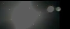
 Mick West replied to the thread A cigar-shaped unidentified luminous object captured on a Xinjiang passenger aircraft [Likely Ski Area].We already have the angular size from the video match (a reasonable match for the ski area). And the reflection is blown out as well. Here's the matching moon from Sitrec
 -
-
 Z.W. Wolf replied to the thread A cigar-shaped unidentified luminous object captured on a Xinjiang passenger aircraft [Likely Ski Area].Yes, already granted. I just thought of something. Although the blown out image is useless, the internal reflection of the Moon in the double paned window should be close to the true apparent size of the Moon. It was just past full and was 98%...
 -
Mick West reacted to flarkey's post in the thread A cigar-shaped unidentified luminous object captured on a Xinjiang passenger aircraft [Likely Ski Area] with
 Like.
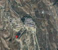
Can you confirm the coords of that white building? In sitrec i get 43.968829, 88.060440 which in GoogleMaps gives this aerial view, which coincidentally again is right beside a ski- slope. Edit - ha ha @Mick West you found it too! :D
Like.
Can you confirm the coords of that white building? In sitrec i get 43.968829, 88.060440 which in GoogleMaps gives this aerial view, which coincidentally again is right beside a ski- slope. Edit - ha ha @Mick West you found it too! :D -
 flarkey replied to the thread A cigar-shaped unidentified luminous object captured on a Xinjiang passenger aircraft [Likely Ski Area].Can you confirm the coords of that white building? In sitrec i get 43.968829, 88.060440 which in GoogleMaps gives this aerial view, which coincidentally again is right beside a ski- slope. Edit - ha ha @Mick West you found it too! :D
 -
-
Mick West replied to the thread A cigar-shaped unidentified luminous object captured on a Xinjiang passenger aircraft [Likely Ski Area].This is actually the exact spot I identified with my first overlay match. I think it's quite possibly this.
-
flarkey reacted to Mick West's post in the thread A cigar-shaped unidentified luminous object captured on a Xinjiang passenger aircraft [Likely Ski Area] with
 Wow.
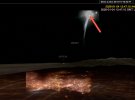
The line is just a measurement arrow that points at the buildings that are in the same place in the recreation as the UFO is in the video. It passes close to the other buildings. We have a 3D recreation of the path of the plane, and can match...
Wow.
The line is just a measurement arrow that points at the buildings that are in the same place in the recreation as the UFO is in the video. It passes close to the other buildings. We have a 3D recreation of the path of the plane, and can match... -
Mick West replied to the thread A cigar-shaped unidentified luminous object captured on a Xinjiang passenger aircraft [Likely Ski Area].The line is just a measurement arrow that points at the buildings that are in the same place in the recreation as the UFO is in the video. It passes close to the other buildings. We have a 3D recreation of the path of the plane, and can match...
-
-
flarkey reacted to Mick West's post in the thread A cigar-shaped unidentified luminous object captured on a Xinjiang passenger aircraft [Likely Ski Area] with Like.
I've added support for ground image overlays. You can drag in a KMZ with one in, or a GeoTIFF. Editing is in the works (but not yet working) With this, there's a reasonable match as per @Trailblazer. Lining things up suggests it's on the ground...
-
Z.W. Wolf replied to the thread A cigar-shaped unidentified luminous object captured on a Xinjiang passenger aircraft [Likely Ski Area]."In this orientation the line to the top is the highway where the bridge is. The image overlay.kml should open it in google earth." To the... ? This is ambiguous. The line at the top of the frame? Which one? The line stretching toward...
-
Source: https://www.youtube.com/watch?v=-OPxatbnCZQ Right click on the ground, and there's a new option: Add Cloud. This adds a cloud region, a very small one above the ppint you clicked on, and opens the cloud editing menu: There, you can...
-
 purpleivan reacted to Mick West's post in the thread A cigar-shaped unidentified luminous object captured on a Xinjiang passenger aircraft [Likely Ski Area] with Useful.
I've added support for ground image overlays. You can drag in a KMZ with one in, or a GeoTIFF. Editing is in the works (but not yet working) With this, there's a reasonable match as per @Trailblazer. Lining things up suggests it's on the ground...
purpleivan reacted to Mick West's post in the thread A cigar-shaped unidentified luminous object captured on a Xinjiang passenger aircraft [Likely Ski Area] with Useful.
I've added support for ground image overlays. You can drag in a KMZ with one in, or a GeoTIFF. Editing is in the works (but not yet working) With this, there's a reasonable match as per @Trailblazer. Lining things up suggests it's on the ground... -
Z.W. Wolf replied to the thread A cigar-shaped unidentified luminous object captured on a Xinjiang passenger aircraft [Likely Ski Area].I can't tell if you're saying that the green line intersects with anything that might be the Mystery Object, or whether the green line intersects with a group of isolated ground lights that are of help with calibrating the witness images to that...
-
Mick West replied to the thread A cigar-shaped unidentified luminous object captured on a Xinjiang passenger aircraft [Likely Ski Area].The green line.