
Reports of drones at Jersey airport (British Channel Islands)

purpleivan

Senior Member.
https://www.bbc.co.uk/news/articles/cqkgl4nmp8lyo
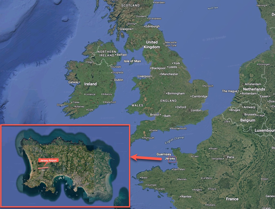
1793554708114.png

External Quote:

People at Jersey Airport have said they are frustrated and angry that "unauthorised drone" activity caused more flight cancellations for a second night in a row.

At 20:05 on Saturday Jersey Airport said it was "experiencing disruption.... affecting inbound flights as a result of further drone activity in the vicinity of the airfield".
States of Jersey Police are investigating the incidents and officers have appealed to anyone with information about who is responsible to come forward.
Insp Rob McCallum said it was believed "two or three" drones had entered the restricted airspace, but they were not thought to be linked to terrorism.
Separate reporting can be found here.
https://jerseyeveningpost.com/news/...ts-spark-major-operation-near-jersey-airport/
External Quote:

Police are appealing for witnesses after the reported activity within restricted airspace and active flight paths caused significant disruption to airport operations and passengers.
The first report came at around 8.20pm, with further drone activity reported until approximately 10.30pm.
I don't have access to historical ADSB data and there is very little information to go on about the drone reports themselves (no videos that I could find), so not much to look into currently, as to what might be misreported as drones, but there is some information regarding time. 8:20pm - 10:30pm on Friday 30th October, 2026, according to the Jersey Evening Post and at 8:05pm Saturday 31st October, 2026, according to the BBC. Time was the same as GMT for both nights.

It may be relevant that these reports occurred on the first Friday and Saturday evenings after the clocks went back in the UK, by one hour (from British Summer Time to GMT), plus with Halloween the on Saturday there would be numerous parties, and other events, as well as fireworks events which are fairly common this weekend, due to Guy Fawkes (bonfire night) being only a few days away on the 5th November. Due to this, more people would likely be outside on those evenings than typical at this time of year, on a night which is darker (judged by the time on the clock) than the previous weekend.

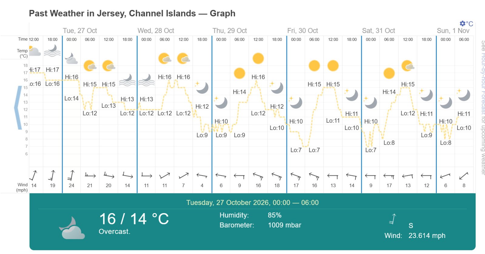
Additionally, the weather was clear those evenings, allowing for easier sighting of distant planes and astronomical objects, potentially being misreported as drones. The previous weekend was partially cloudy with rain, so a contrast to the conditions for those out and about on weekend activities, for that weekend, compared with the Friday and Saturday of the nights of the drone reports.

The weather for those nights can be found here.
https://www.timeanddate.com/weather/@6619950/historic
Weather Jersey.jpg


There's plenty of air traffic nearby, with flights from airports around London, to Spain and Portugal, plus some transatlantic traffic between North American and Europe, passing close by, or over, the island of Jersey.

No mention in the reporting I've seen so far, as to whether the reports of drones were eyewitness statements only, or included videos, or radar.

Edit: Adding a comment to say it's just occurred to me, that the clocks going back in the UK a few days before the drone reports, probably has no relevance, as it would have been dark before 8pm both before and after the change.
 
Last edited by a moderator:
The first sighting was supposedly at 8.20pm, which by coincidence is exactly when a high-altitude easyJet flight passed directly over Jersey airport. Several other planes followed this same flight path over the next couple of hours. Friday was also the first very clear night for a while in the Channel Islands.


IMG_1988.PNG
 
This British Airways flight seems to be the first one that was diverted: it returned to Heathrow.

IMG_1990.jpeg


Hard to say exactly when the diversion took place as I'm not sure what the normal flight path would have been. It looks as if it continued some way past Jersey before turning back but perhaps it would have looped back round to land?

U28042 is the easyJet flight that is in the Sitch above. A sighting with that flight fairly low on the horizon around 8.10 to 8.15pm would be consistent with the diversion.
 
Last edited by a moderator:
Is it possible to insert "(UK)" after "Jersey" in the title? Given the other 'Jersey drone flap, t might help prevent confusion for those searching for such a thread...
<Mr Burns>
There's a NEW Jersey?
</Mr Burns>

Being really pedantic, Jersey isn't part of the UK. But there's no simple shorthand that really works - "Channel Islands" would probably confuse Californian readers

Edit: I have dusted off my Moderator powers to edit the title.
 
Is it possible to insert "(UK)" after "Jersey" in the title? Given the other 'Jersey drone flap, t might help prevent confusion for those searching for such a thread...
Look like someone beat me to it and inserted "British Channel Islands" in the title.

Funnily enough, I had the same reaction when I read the report on the BBC, that this was a repeat of the New Jersey drone flap. I even started typing a comment near the top of the OP, to make it clear this was the original Jersey (UK) and not the New one on the other side of the Atlantic.

However, I thought "ah... it's just me who'll read it that way" and left it out.
 
The MoD tell me the RAF have not deployed to Jersey.

That begs the question where Jersey will get counter-drone from unless a police unit such as NPCC is going to assist them, or maybe Jersey police have something basic like AeroScope.

1000062403.png
 
The States of Jersey Police have appealed for any information about the sightings. I have sent them an email outlining the potential for mistaken identity (giving examples of the bogus sightings in the UK, Europe and the US) and details and times of the planes.

There was a further report shortly after 8pm yesterday (Saturday October 31) which also appears to coincide with a plane on the same flight path.

Edit: and I had an auto-reply followed by a (very brief) personal reply within 5 minutes.

1793558728400.png
 
Last edited:
The States of Jersey Police have appealed for any information about the sightings. I have sent them an email outlining the potential for mistaken identity (giving examples of the bogus sightings in the UK, Europe and the US) and details and times of the planes.

There was a further report shortly after 8pm yesterday (Saturday October 31) which also appears to coincide with a plane on the same flight path.

Edit: and I had an auto-reply followed by a (very brief) personal reply within 5 minutes.

View attachment 93938
Nice that they've logged and replied.
 
And I predict that the drone sightings may well dry up for the rest of the night. The clear skies to the south are now being blocked out by fog and low cloud moving from the north.

1793562574515.png
 
I'm from Jersey and have been doing some agent-assisted research into the flight tracks.

Saturday's high-altitude overflight appears to have been BA2719 (G-GATU), flying Funchal–Gatwick at around 34,000ft, passing almost directly overhead at approximately 20:05. That seems worth investigating as a possible misidentification, although 20:05 was the airport's announcement time, not necessarily the original sighting.

https://planetrack.ai/aircraft/407022

Sunday was interesting too. There was another reported drone warning around 18:51, but flights resumed fairly quickly. One passenger on BA2525 reported at 19:10 that the drone was no longer being sighted and they were cleared to depart. I'd be interested to know what prompted the original warning and why it was lifted so quickly.


Source: https://x.com/CharlesPerree/status/2116971042040344665


I can understand why locals trust airport staff and officials, especially when flight disruption is already such a sensitive issue here.

I'm not suggesting there weren't drones, or that precautionary restrictions were unjustified. But I think misidentification deserves proper consideration before conclusions become accepted as fact, public money is committed to new systems, or further restrictions are introduced.

Drones are popular in the Channel Islands, and plenty of responsible operators understand the airport restrictions. It would be unfortunate if unverified sightings led to unnecessary hostility towards them.

Has anyone established the exact times, locations and directions of the original sightings? That seems essential to testing either explanation properly.
 
Think I might have been blagged, an RAF transport (the kind you'd expect for a C-UAS deployment) has just landed at Jersey.

An Airbus A400M, so capable of carrying some substantial kit as well as personnel if necessary,
"AirNav radar" website https://www.airnavradar.com/data/airlines/rrr

a400.png


If I understand correctly, it was only on the ground at Saint Helier (Jersey) for 37 minutes before returning to MOD Boscombe Down (near Amesbury, ICAO airport code EGDM, Wikipedia https://en.wikipedia.org/wiki/MOD_Boscombe_Down).
 
Last edited:
I'm from Jersey and have been doing some agent-assisted research into the flight tracks.

Saturday's high-altitude overflight appears to have been BA2719 (G-GATU), flying Funchal–Gatwick at around 34,000ft, passing almost directly overhead at approximately 20:05. That seems worth investigating as a possible misidentification, although 20:05 was the airport's announcement time, not necessarily the original sighting.

https://planetrack.ai/aircraft/407022

Sunday was interesting too. There was another reported drone warning around 18:51, but flights resumed fairly quickly. One passenger on BA2525 reported at 19:10 that the drone was no longer being sighted and they were cleared to depart. I'd be interested to know what prompted the original warning and why it was lifted so quickly.

Yes I had noticed the timing of that flight on Saturday. Note that the plane would have appeared to be "hovering" for several minutes before passing over the airport (my Sitrec view of the Friday flight was five minutes before it passed over, when it was still about 40 miles from Jersey).

You'd think though that if someone was watching the "drone" they would eventually see it continue to fly directly overhead and become more obviously a plane?

Regarding yesterday's sighting, it's notable that it coincided with the part of the early evening when the sky was clear to the south of Jersey. Later in the evening the weather satellite images show lots of low cloud which would have prevented sightings of high altitude flights, although there were intermittent gaps. (Satellite loop is available at https://zoom.earth/)

Planes passed overhead yesterday on the same SW-NE flight path at 18:20 (BA507) and 18:45 (LS3180). I think the latter may have been associated with the temporary airport closure, as a private jet (VIP1) landed at 18:32 and a Loganair flight to Southampton (LM557) took off at 18:36.

There was then another overflight at 19:06 (LS3644), and another at 19:16 (BY4745), but those don't seem to have stopped the departure of BA2525 at 19:19 – this is the flight whose passenger tweeted about the delay.

BA2525 was scheduled to depart at 19:00. Flightaware actually reports it leaving at 18:45, 15 minutes early, but it didn't actually leave the ground until 19:19. Presumably it left the gate early and was recorded as a departure even though it was then held on the ground.
 
It's interesting that the 18:45 overflight coincided with a gap in the cloud over the airport:

1793613145107.png


By time the 19:06 and 19:16 planes flew over, there was more cloud over the airport (hard to tell exactly how much as the satellite frames are obly every 10 minutes)

1793613270097.png


The forecast for tonight looks fairly cloudy so let's see if the drones come back this evening...
 
It's interesting that the 18:45 overflight coincided with a gap in the cloud over the airport:

View attachment 93951

By time the 19:06 and 19:16 planes flew over, there was more cloud over the airport (hard to tell exactly how much as the satellite frames are obly every 10 minutes)

View attachment 93953

The forecast for tonight looks fairly cloudy so let's see if the drones come back this evening...
Will it be the clouds or are the drone people scared off by the arrival of whatever was on that RAF plane :)
 
Yes I had noticed the timing of that flight on Saturday. Note that the plane would have appeared to be "hovering" for several minutes before passing over the airport (my Sitrec view of the Friday flight was five minutes before it passed over, when it was still about 40 miles from Jersey).

You'd think though that if someone was watching the "drone" they would eventually see it continue to fly directly overhead and become more obviously a plane?

Regarding yesterday's sighting, it's notable that it coincided with the part of the early evening when the sky was clear to the south of Jersey. Later in the evening the weather satellite images show lots of low cloud which would have prevented sightings of high altitude flights, although there were intermittent gaps. (Satellite loop is available at https://zoom.earth/)

Planes passed overhead yesterday on the same SW-NE flight path at 18:20 (BA507) and 18:45 (LS3180). I think the latter may have been associated with the temporary airport closure, as a private jet (VIP1) landed at 18:32 and a Loganair flight to Southampton (LM557) took off at 18:36.

There was then another overflight at 19:06 (LS3644), and another at 19:16 (BY4745), but those don't seem to have stopped the departure of BA2525 at 19:19 – this is the flight whose passenger tweeted about the delay.

BA2525 was scheduled to depart at 19:00. Flightaware actually reports it leaving at 18:45, 15 minutes early, but it didn't actually leave the ground until 19:19. Presumably it left the gate early and was recorded as a departure even though it was then held on the ground.

Sunday's event seems to be the most likely false alarm, meaning it's helpful for us to determine a pattern for the others.

I've made a sitrec for one of the planes you mentioned, I think it's a very small window for when it would've been seen 'hovering'. But still could be an explanation.

Jersey Sunday 1 Nov 2026 – LS3180 G-SUNU Airport View
 
Sunday's event seems to be the most likely false alarm, meaning it's helpful for us to determine a pattern for the others.

I've made a sitrec for one of the planes you mentioned, I think it's a very small window for when it would've been seen 'hovering'. But still could be an explanation.

Jersey Sunday 1 Nov 2026 – LS3180 G-SUNU Airport View

If the observer's perception has been conditioned to see a small object hovering, then even when the plane flies overhead it is possible, with no other reference points, that it could be perceived as a small drone at low altitude rather than an airliner at high altitude. Depth cues are basically absent when looking at a plane with flashing lights in a dark sky.

So a plane with a 35 metre wingspan at 38,000ft could be perceived as a drone with a wingspan of 35cm at 380ft, if that's what you were conditioned to see.

During the New Jersey flap I went outside on clear nights and watched planes flying over and tried to "see" them as low-altitude drones. It was actually surprisingly easy.
 
Just for some broader context and to maybe help answer the question of how often you would expect to see planes over Jersey, I ran a query on adsb.aero for traffic above 15,000 ft that crossed through my hastily-drawn bounding box in the week Oct 26 - Nov 1.

1.jpg


I stopped loading more flights at 1,500 since this poor little Mini PC I'm on was about to go up in flames. Turns out Jersey sits pretty much directly under the N/S London and E/W Paris corridors, amongst various other routes, so plane traffic is abundant. I'm sure you can come up with more useful queries if you need to.

This is the KML export of the above query in Google Earth, both wider view and zoomed in on the island.

2.jpg


2z.jpg


(Note there appears to be some Jersey airport traffic included here as well. I suppose this is because of spurious altitude data. In the grand scheme of things it is little more than a footnote.)
 
This is the KML export of the above query in Google Earth, both wider view and zoomed in on the island.
The flight path that passes directly over Jersey airport in a SW-NE direction shows up very clearly there.
1793634247549.png


Of course, you have to wonder why locals would not be used to seeing traffic on that exact route night after night. Perhaps it is just a seasonal thing, and we should expect the drone sightings to appear every year around Halloween.
 
Back
Top