Moscow Spiral Contrail / Helix Cloud - Theories

Guys,

I believe these are orbital entropic dark matter particle contrails. Two particles orbiting each other in a Kepler orbit, condensing water vapor by removing enthalpy and entropy from their surroundings. They are passing right through the Earth. Those particles will be tiny but massive, travelling hundreds to thousands of miles/sec. They are expelled from the sun during soronal mass ejections (CMEs) and solar flares. They are the missing 95% mass/energy in the universe. darkmattersalot.com

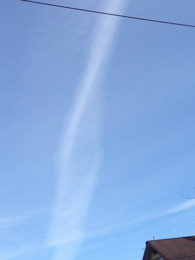
You might want to do the math on that one.
 
Guys,

I believe these are orbital entropic dark matter particle contrails. Two particles orbiting each other in a Kepler orbit, condensing water vapor by removing enthalpy and entropy from their surroundings. They are passing right through the Earth. Those particles will be tiny but massive, travelling hundreds to thousands of miles/sec. They are expelled from the sun during soronal mass ejections (CMEs) and solar flares. They are the missing 95% mass/energy in the universe. darkmattersalot.com

Um, I majored in Astrophysics, and that's a lot of pure baloney.
BTW, I Googled that nonsense and found it all over the place.
Thanks for the good laugh at a lot of scientific words formed into
a bunch of meaningless Doubletalk.
 
Just saw the pics from Russia. I thought I'd share these I took over Portland Oregon on February 15th. I wish they were better pics, but I was floored by the uncanny likeness do the double helix. How does this happen?

DHELIX1FEB 15.jpg DHELIX2.jpg DHELIX3.jpg
 
Last edited by a moderator:
I have found photos of a recent similar helical contrail and identified a candidate flight that may provide insight into the formation of helical contrails. Initially, I came across of two similar images of a twisted sunset contrail, taken on April 21, 2015:


As both authors appear to live near Brighton, England, I've searched for more photos from this area taken on that date and found a few more pictures. They confirmed the location and provided a wider angle view of this contrail and the time of its observation:


The bent and twisted trail is a part of a longer broken trail that continued after a gap. In the last photo, taken at 20:12 BST (19:12 UTC), we can see the beginning of this trail, where the plane was at the time. This allowed an easy identification of the candidate flight (FR26) on Planefinder.net:
Screen shot 2015-05-08 at 17.26.57.png
A slight bent in the plane track was exaggerated by perspective shortening in the contrail images. What went missing from the above screenshot is that while correcting its course the plane also descended from 39,000 ft to 33,000ft. During this descent, the plane apparently passed through a layer of moist air and probably encountered a vertical wind shear (K-H instability) that had twisted its contrail into a helix. Indeed, there was a rather complex pattern of the forecasted wind at 250 hPa in this area:
Screen shot 2015-05-08 at 19.24.35.png

This suggests the possibility of Moscow spiral contrail also having resulted from the plane encounter with a vertical wind share while descending or ascending through a layer of moist air.
 
Last edited:
I know, pics or it didn't happen - honest guv! I just didn't have the time but around that date I too (from Dorset, UK) saw a (my first) twisted contrail (as if the aircraft had carrried out a barrel roll while contrailing).
 
I think this was a helical contrail.


5/13/15 7:32CDT, looking just north of west at IL59 and CR33/75th St. [edit: a town would be nice. Naperville, IL.] The aircraft was still visible to the north at this time.
 
Last edited:
I think this was a helical contrail.


5/13/15 7:32CDT, looking just north of west at IL59 and CR33/75th St. [edit: a town would be nice. Naperville, IL.] The aircraft was still visible to the north at this time.

Yes, this helical contrail looks like the OP contrail probably looked from a side. The candidate flight matching your time, location and the trail direction is probably this UAE221 A380:
Screen shot 2015-05-14 at 08.26.38.png

It was a level flight, so the contrail's relatively short length is probably due to crossing a narrow band of moist air, as seen in the wind and relative humidity forecast at 250 hPa:
Screen shot 2015-05-14 at 08.49.41.png

Switching the Earth forecast display to wind speed only shows that the plane was crossing the jetstream at the time with the wind speed dropping a bit in the moist air band:
Screen shot 2015-05-14 at 08.56.34.png
This horizontal wind shear could be a cause of the turbulence that twisted the contrail into a helix.
 
I have found photos of a recent similar helical contrail and identified a candidate flight that may provide insight into the formation of helical contrails. Initially, I came across of two similar images of a twisted sunset contrail, taken on April 21, 2015:


I have photos of a very similar trail (maybe even the same one?) taken on the same evening, April 21, from central London. They are on my phone, I will edit to add them in to this post...

Edit: here they are.

One to give wider context. Taken at exactly 20:00 BST (19:00Z)

image.jpg

Close-up, with moon above, taken at 20:01 BST:

image.jpg

A little later, at 20:23 BST. Note two more short twisted contrails next to it:

image.jpg

And 20:25 BST:

image.jpg
 
Last edited:
Yes, this helical contrail looks like the OP contrail probably looked from a side. The candidate flight matching your time, location and the trail direction is probably this UAE221 A380:
Screen shot 2015-05-14 at 08.26.38.png

It was a level flight, so the contrail's relatively short length is probably due to crossing a narrow band of moist air, as seen in the wind and relative humidity forecast at 250 hPa:
Screen shot 2015-05-14 at 08.49.41.png

Switching the Earth forecast display to wind speed only shows that the plane was crossing the jetstream at the time with the wind speed dropping a bit in the moist air band:
Screen shot 2015-05-14 at 08.56.34.png
This horizontal wind shear could be a cause of the turbulence that twisted the contrail into a helix.

Actually the flight was traveling Southwest to Northeast. The sun is just out of frame to the lower left. I kicked myself after for not getting a shot of the aircraft too for context, but I did a quick swing into a parking lot to get the one I did.
 
Actually the flight was traveling Southwest to Northeast. The sun is just out of frame to the lower left. I kicked myself after for not getting a shot of the aircraft too for context, but I did a quick swing into a parking lot to get the one I did.
It was naughty of you:oops: I've just assumed that the time 7:32CDT was AM. A potential sun glare in supposedly western sky should have alerted me that it could be PM (5/14/15 00:32 UTC).
A new candidate flight is this private jet that was descending from 45,000 ft toward the lake:
Screen shot 2015-05-14 at 12.59.19.png

The relative humidity forecast in 12 hours was different, but it suggested the presence of a humid layer in the area through which the plane descended, whereas the wind forecast showed the presence of jetstream and horizontal wind shear.
 
Last edited:
Back
Top