Flying back and forth

rojoda

New Member
Hi. I'm new to posting here, but have read a few posts on the blog.

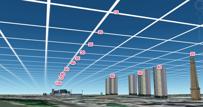
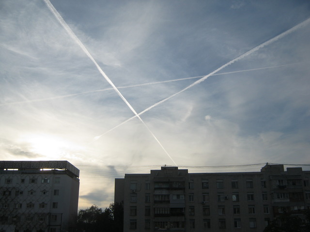
Just curious if this has been discussed yet and explained. While living in northern Europe I noticed the usual 'mass contrail' phenomenon, but in most cases, the grid patterns were created by one plane, not several as would be the case with normal passenger air traffic. A friend of mine who's been in the military immediately recognized this as typical military operations. However, it went on for the entire two years I remained there, on a weekly basis. On every clear day, with the exception of those with very strong winds, I observed this solo plane contrail pattern. It was always within just a few hours of sunset, so around 11 am on winter days, and much later on summer days, and the grids would on every occasion meld into a cirrostratus type formation with a pretty heavy haze. The haze would persist for 1-3 days after, in general.

I would point this out to family when coming to visit and after some persistent observation, they too noticed the plane turning around and coming back. The individual contrails would line up neatly one after the other, and then the perpendicular ones were created in the same orderly fashion.

Whenever I traveled around the country, I would notice a similar pattern, but I did not tend to sit in one place for long enough to observe if these were made by a solo plane or not, as I would at home sitting on my porch. I do know my friend, who brought these to my awareness in the first place, had taken notice of this, and today I listened to a youtube video in which a man has a conversation with local air traffic authorities and he too described the exact same scenario. So I'm itching to receive an answer to what this could be about. The control officer suggested it may be an air show, but I doubt they were having air shows on a weekly basis in my home town;), esp not for two years and likely still. He finally said not to worry cause they know what they're doing. The concerned citizen claimed his partner had phoned the local police some days prior who had responded that a geoengineering project was taking place in Sweden. But of course, no way to verify that.

To clarify, I do not believe in chemtrails (the idea that the population is being deliberately poisoned with chemicals from airplane contrails).
 
No, I never did. I don't live there anymore. Except for once, they were all very high up (but not as high as other passenger planes I see). The one I could see more closely was darker and its shape made me think of a military type plane, but I really know nothing about planes. The ones up high, I believe were white-ish in color, if that says anything. The youtube guy I mentioned above also described the planes as such, and I think he had binoculars.
 
No, I never did. I don't live there anymore. Except for once, they were all very high up (but not as high as other passenger planes I see). The one I could see more closely was darker and its shape made me think of a military type plane, but I really know nothing about planes. The ones up high, I believe were white-ish in color, if that says anything. The youtube guy I mentioned above also described the planes as such, and I think he had binoculars.

You could still have a look on flightradar24 at the area you were in to see if you can identify the flights. People often claim the trails come from one plane when in reality it's different planes flying the sane route. Remember though that the planes could be a lot further away than you think.
 
Probably AWACS planes?

Google says there are E-3 Sentries at Stavanger ("Sola"), Sweden, and at Ørland, Norway.
 
By the look of them on wiki, they could be. Are they shorter than regular passenger planes?

What would they be doing if flying on such a regular basis all over Sweden (or at least the southern half, don't know about the north)?

Stavanger is in Norway.

I've never used flightradar24, I wish I had known about it then. It seems there are quite a few types of planes that do not show up on flightradar though. Trying to figure out how to use it.

When you say they could be different planes flying the same route, that would exclude instances where planes are seen actually turning around?

The first time I took notice of anything was during a heavy storm we were having over Christmas two years ago. A big one came in Christmas day and the following day there was a lull before another, larger one came in. During the lull I observed planes flying back and forth with the grid forming a very ominous looking black haze cover in well under 20 minutes. It happened very quickly and it caught my attention. I could make out the details of those planes quite well as they were flying very low.

Would either of you have any idea as to why the cirrostratus formations are so frequent (like on every clear day) and why they're always forming from dense grids a few hours before sunset? And why they're always concentrated over the part of the sky where the sun is setting, or why the trails in the grid are formed one after the other, in an orderly fashion? Is air traffic directed like this for any specific reason?

The Swedish Meteorological and Hydrological Institute maintains on their website that cirrostratus formations from contrail grids are seen on occasion only. I observed these forming 2-4 times a week. Daily in the summer months.
 
Got the map to load correctly with actual planes on, just had to switch browsers. Great tool. Would you say the vast majority of planes show up on flightradar?
Those AWACS wouldn't show up though, would they?
 
If you've seen them turning around then naturally that would rule out different planes flying the same route. Often though people will see a plane apparently returning having disappeared from view and assume it's the same one coming back. I don't think the AWACS would show up but you can get more info on what does here: http://www.flightradar24.com/how-it-works

Can't really comment on the comments about grids and cirrostratus at sunset other than it may be more noticable when lit by the setting sun. There's more info on how the grids can form here though http://contrailscience.com/contrail-grids-are-not-chemtrail-grids/

Increased contrails will normally proceed a weather front as the humidity at altitude increases
 
Would either of you have any idea as to why the cirrostratus formations are so frequent (like on every clear day) and why they're always forming from dense grids a few hours before sunset? And why they're always concentrated over the part of the sky where the sun is setting, or why the trails in the grid are formed one after the other, in an orderly fashion? Is air traffic directed like this for any specific reason?
These are common questions, and understandable ones at first glance. :rolleyes:
Read these two articles.....but please read them, all the way through.....it may help you understand what's going on here.

http://contrailscience.com/contrail-grids-are-not-chemtrail-grids/

http://contrailscience.com/30-years-of-airline-travel/

BTW....from the ground and just your eyes, you will not likely be able to tell if it is one plane flying back and forth. People who have investigated this with strong binoculars, long camera lens, and even telescopes have verified that nearly all of the time the "one plane" is actually many different planes flying from point A to point B (not back-and-forth), mostly all commercial/cargo planes. Yes, some military too....but more rare.
 
I don't think what I observed in those locations fit the description of 'old' contrails drifting in from the east and mixing with new (straight up) ones, if I understood that correctly. All the significant trails I noticed were made 'fresh'. But yeah, come colder weather and more contrail visibility, I will keep this in mind and see how that fits in.
As for there being several planes creating the various trails in a grid, that would mean quite a few planes criss-crossing over the same spot in a fairly short amount of time. Looking at the flightradar, there were no planes at all over my previous locations (about 2 hours west of a major airport with most traffic seemingly going south or east). An hour later, still no flights. It's early morning there now, I will check in the morning here.

If this is not weather modification going on, but simply commercial air traffic, I think we're still and definitely in serious trouble. I don't know where you all live, but in Sweden, the sun was constantly blocked out by contrail-induced heavy cloud cover. I can't say for sure those planes turned around and came back as they're too far off, but the trails merging and forming the hazy cover is unmistakable, intentional weather modification or not.

Stupid, the investigations you're referring to, are these in very heavily trafficked areas or in instances covering a longer period of time to allow for several commercial planes to fly from point A to B?

What I'm seeing on flightradar right now is similar to how I remember how the sky looked like a couple of decades or so ago. Just one flight here and there, not the constant back and forth traffic (not just judging the presence of contrails, but actual planes which I've always been able to spot easily).
 
I don't think what I observed in those locations fit the description of 'old' contrails drifting in from the east and mixing with new (straight up) ones, if I understood that correctly. All the significant trails I noticed were made 'fresh'. But yeah, come colder weather and more contrail visibility, I will keep this in mind and see how that fits in.
As for there being several planes creating the various trails in a grid, that would mean quite a few planes criss-crossing over the same spot in a fairly short amount of time. Looking at the flightradar, there were no planes at all over my previous locations (about 2 hours west of a major airport with most traffic seemingly going south or east). An hour later, still no flights. It's early morning there now, I will check in the morning here.

Something to bear in mind http://contrailscience.com/how-far-away-is-that-contrail/

If this is not weather modification going on, but simply commercial air traffic, I think we're still and definitely in serious trouble. I don't know where you all live, but in Sweden, the sun was constantly blocked out by contrail-induced heavy cloud cover. I can't say for sure those planes turned around and came back as they're too far off, but the trails merging and forming the hazy cover is unmistakable, intentional weather modification or not.

Sweden seems to have been pretty clear yesterday

http://lance-modis.eosdis.nasa.gov/imagery/subsets/?subset=BalticSea.2013255.terra.2km
 
Last edited:
..... An hour later, still no flights. It's early morning there now, I will check in the morning here.

...........What I'm seeing on flightradar right now is similar to how I remember how the sky looked like a couple of decades or so ago. Just one flight here and there, not the constant back and forth traffic (not just judging the presence of contrails, but actual planes which I've always been able to spot easily).

Here's what I see:
http://www.flightradar24.com/58.88,-0.32/6

stavanger_norway.jpg
 
Stupid, that picture is from southwestern Norway. Norway has a lot of mountains and difficult terrain making it hard to drive even shorter distances, so they tend to have more air traffic. My location was Sala, Sweden. The closest major city west of us is Oslo which is pretty far away with nothing in between and with Arlanda straight east of us I'm assuming most flights passing over there would be Oslo-Stockholm flights. I have no way to check traffic in real time for daytime hours, I'll see if I can find out how to check on past flights.

Thanks for that link, I didn't know how far away those trails can be seen. Doesn't help me much now of course since I'm no longer there. Northbound flights to Stockholm may of course show up in the lower southern sky; I think they pass about 45-55 miles to the south. Another location I would spend time at for days at a time seems to have received most of the contrails in the path leading from Göteborg to Stockholm. I never realized how much cloud coverage these contrails create in their path. Pretty depressing.

When they say planes are usually at 6 miles overhead when contrails are created, is this at a height where a plane is pretty easily identifiable? I've seen that too, with very large contrails behind it and going vertically, not horizontally.

Any thoughts on why cirrostratus blankets would be formed so frequently? None of that happened the first year I lived there for this stretch of time. Would that be because of drier climate? The only difference I noticed was an extremely cold winter. The skies were sunnier growing up, definitely not that thick haze at all times. If contrails are visible the most when cloudy weather is coming in, do contrails exacerbate it? They say Scotland is getting wetter than normal, perhaps that applies to Sweden too. Glad I'm not there anymore!

Thanks for answering all my questions.
 
Thanks for that link, I didn't know how far away those trails can be seen. Doesn't help me much now of course since I'm no longer there. Northbound flights to Stockholm may of course show up in the lower southern sky; I think they pass about 45-55 miles to the south.

You can see contrails up to around 100 miles away.

See:
http://contrailscience.com/how-far-away-is-that-contrail/

When they say planes are usually at 6 miles overhead when contrails are created, is this at a height where a plane is pretty easily identifiable? I've seen that too, with very large contrails behind it and going vertically, not horizontally.

Not vertically, coming towards you:
http://contrailscience.com/contrails-are-usually-horizontal/
 
Last edited:
I live near an Air National Guard base. There are many days they have a plane in the air continually flying in a circle.
 
I didn't live in Norway:). Sweden. We don't face the Atlantic so it's a little different considering there is a mountain range separating us.

I probably didn't explain my question very well. There are naturally forming clouds and then there are cloud formations that come out of contrails (contrails are vapor after all).
According to SMHI (Swedish Meteorological and Hydrological Institute), the heavy blanket type formations are only occasionally formed by contrails, in Sweden. Perhaps you haven't seen this happen yourself, but it's very clear when contrails merge together and form this blanket as opposed to naturally existing clouds merging together to form a similar condition.

Looking at images on google, it seems altostratus (undulatus) is the formation I'm referring to. Cirrostratus is not dense enough. What I saw was very heavy, dense and dark. No rain usually.

So my question is, why would contrails in Sweden create altostratus formations on such a frequent basis when SMHI says it happens only on occasion? I observed this 2-4 times or so on a weekly basis. I remember seeing this growing up, but it wasn't days on end, week after week, month after month. In fact, when I came to the upper midwest as a young adult, we had a winter with seemingly endless heavy cloud cover and I told my husband what strange weather. After living here for over a decade, I'd say it's more 'typical' of weather here than in Sweden. Perhaps it's windier in Sweden where clouds move through faster.

I don't think I've seen planes flying in circles.
 
Curious too if anyone can point me to a post about cloud seeding and other weather modification operations, and how we can tell them apart from regular air traffic.
 
Curious too if anyone can point me to a post about cloud seeding and other weather modification operations, and how we can tell them apart from regular air traffic.

@Jay posted this article just yesterday:

https://www.metabunk.org/threads/interes...e-on-cloud-seeding-weather-modification.2402/

Typically, cloud seeding doesn't involve persistent, spreading trails from jets at high altitude...its more like burning flares from small planes into already existing rain clouds...or shooting rockets from the ground.


Can you explain how you know and/or why you think it is the same plane flying back and forth? Do you see it turn around? I have heard this a lot but have never seen it demonstrated.
 
Last edited by a moderator:
According to SMHI (Swedish Meteorological and Hydrological Institute), the heavy blanket type formations are only occasionally formed by contrails, in Sweden. .
You need to define this down further. What exactly do they mean by occasionally? I occasionally drink beer, sometimes I do so every day. See?

The upper atmosphere is seldom static, occasionally winds are 100 miles/hour. Usually the contrails you see are either blown in or form overhead and are blown away. Often the altostratus you see are blown in from elsewhere and precede frontal changes. Occasionally the clouds lower and it ends up raining.

Perhaps you are reading too much into the word occasionally. That is what I am saying.
 
Can you explain how you know and/or why you think it is the same plane flying back and forth? Do you see it turn around? I have heard this a lot but have never seen it demonstrated.

I suppose because of how the contrails form rather precisely, like one after the other and the time it takes for one trail to form in succession to the next. I'd sit out on my porch for an hour or two at the most, at the beach maybe three hours. I can't imagine these trails are blown in since a plane is visible at the head of each trail. I'm sure I've witnessed contrails which *have* blown in, it's just that they're not part of the particular observation I'm referring to.
No, I don't believe I've seen the plane actually turn around since they're just too far away. It just looks like a drawing pad with a grid being drawn, first going one way, then the opposite way and so on. But hey I'm not saying this is so, just that it looked that way.

You need to define this down further. What exactly do they mean by occasionally? I occasionally drink beer, sometimes I do so every day. See?

The upper atmosphere is seldom static, occasionally winds are 100 miles/hour. Usually the contrails you see are either blown in or form overhead and are blown away. Often the altostratus you see are blown in from elsewhere and precede frontal changes. Occasionally the clouds lower and it ends up raining.

Perhaps you are reading too much into the word occasionally. That is what I am saying.

I get your point. Sure, occasionally in English can refer to an irregular pattern of regularity but in Swedish it literally means 'single times' (enstaka gånger). But heck, even in English occasionally would never translate to 2-4 times per week for at least two years straight. Especially not in a location where altostratus is not that common of a climatic feature.

What I observed was not altostratus formations blowing in from elsewhere; I saw actual contrails merging together and forming altostratus clouds. Many times I also saw the contrails being formed straight above (not blown in) before seeing the altostratus form.

This happened for nearly two years before leaving the area. I'm not suggesting this is done intentionally, but that perhaps contrails in certain locations are having some pretty significant effects on the weather.
 
There are naturally forming clouds and then there are cloud formations that come out of contrails (contrails are vapor after all).

Contrails are tiny ice particles, not water and not water vapor. At low pressures (somewhat 350-300 hPa or lower) they form in very cold air (less than -40 deg. C). At the ground level (1000 hPa) the threshold changes to -29 deg C. Middle-layer clouds are somewhat warmer (-33 deg. C and higher).

I'm sure that altostratus are advected (blown in) in your region. They are just too low and warm to be formed from contrails (3-6 km, but contrails form at 8-12 km). This image can help:

 
Last edited by a moderator:
I didn't live in Norway:). Sweden. We don't face the Atlantic so it's a little different considering there is a mountain range separating us.

I probably didn't explain my question very well. There are naturally forming clouds and then there are cloud formations that come out of contrails (contrails are vapor after all).
According to SMHI (Swedish Meteorological and Hydrological Institute), the heavy blanket type formations are only occasionally formed by contrails, in Sweden. Perhaps you haven't seen this happen yourself, but it's very clear when contrails merge together and form this blanket as opposed to naturally existing clouds merging together to form a similar condition.

Looking at images on google, it seems altostratus (undulatus) is the formation I'm referring to. Cirrostratus is not dense enough. What I saw was very heavy, dense and dark. No rain usually.

So my question is, why would contrails in Sweden create altostratus formations on such a frequent basis when SMHI says it happens only on occasion? I observed this 2-4 times or so on a weekly basis. I remember seeing this growing up, but it wasn't days on end, week after week, month after month. In fact, when I came to the upper midwest as a young adult, we had a winter with seemingly endless heavy cloud cover and I told my husband what strange weather. After living here for over a decade, I'd say it's more 'typical' of weather here than in Sweden. Perhaps it's windier in Sweden where clouds move through faster.

I don't think I've seen planes flying in circles.

Looking at the geography and climate of Sweden, naturally occurring altostratus and cirrostratus nebulosus, a.k.a. "heavy blanket type formations" should be common. And due to the mountains, lee wave clouds are quite common as well. I'm pretty sure what they mean is that out of the total occurrence of stratus clouds blanketing the sky, only occasionally are they formed by contrails. I live in the Willamette valley of Oregon, also with a mountain range between us and the Pacific, where stratus clouds at various heights pretty much define the weather for much of the year except in June, July and August. I believe it's a similar situation in Sweden except the least cloudy months are April, May and June. It seems your idea of what weather should be like in Sweden does not match real world climatological data.

http://www.sweden.climatemps.com/

http://www.worldweather.org/096/c00187.htm

http://www.weather-and-climate.com/average-monthly-Rainfall-Temperature-Sunshine,Stockholm,Sweden

http://onlinelibrary.wiley.com/stor...ph&s=017003a04ed1c73e7bf98b5e52105c8214b6edd7

http://www.clouds-online.com/cloud_atlas/cirrostratus/cirrostratus.htm#cirrostratus
 
I'm sure that altostratus are advected (blown in) in your region. They are just too low and warm to be formed from contrails (3-6 km, but contrails form at 8-12 km).

In other words, you are saying that although one may perceive contrails as merging and 'forming' cirrostratus or altostratus, it's not what's actually happening? As in when they blow in and contrails are present, the trails will appear to form them although they are not? And that while SMHI say so themselves, this doesn't happen in Sweden because of the aforementioned climatic conditions...? I'm just wondering if what I saw was not contrails forming cirrostratus, then how *does* it look like, and how do we know what's causing it?
 
Yes this has been known since before WWII, as in this I wrote in 1999:
http://goodsky.homestead.com/files/deception5.html

Thanks for your link. Creating weather, for sure. I imagine that airplane traffic was high during they war while commercial flight traffic was much lighter than today.

I lived in Sweden for two decades--it is not like the wet coast, USA--most of the cloud cover was in the form of partial clouds, not overcast, during the warmer months.
 
rojoda,

I've seen a very interesting persistent contrail event three days ago. It's very close to what you describe. Six or seven trails formed overhead, creating a geometric shape. It was the fore part of an upper trough, and altostratus followed immediately. It could seem that the trails formed the middle layer of clouds, but in fact they didn't.


The weather change on the next day was very interesting. A wave-like surface low has formed directly in Moldova, creating a source of low-level convergence and upper-level lift. A CAPE of just 200-500 J/kg was enough to cause abundant convection with heavy rains (20-30 mm in 1 hour or less) and flash floods.
 
Last edited by a moderator:
Back
Top