Delta IV Heavy Launch from Vandenberg, California

Mick West

Administrator
Staff member
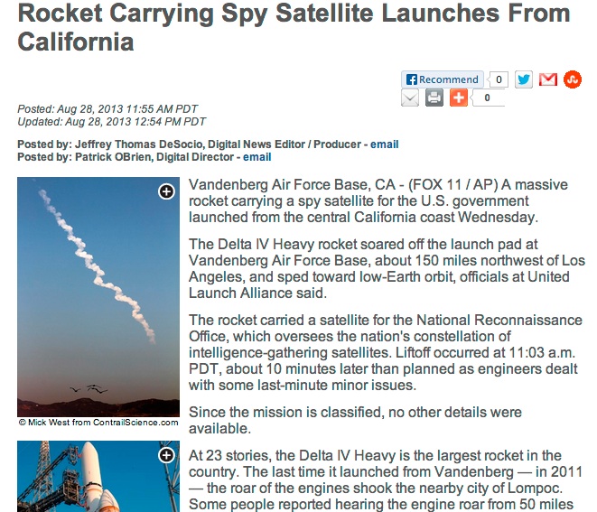
http://spaceflightnow.com/delta/d364/status.html

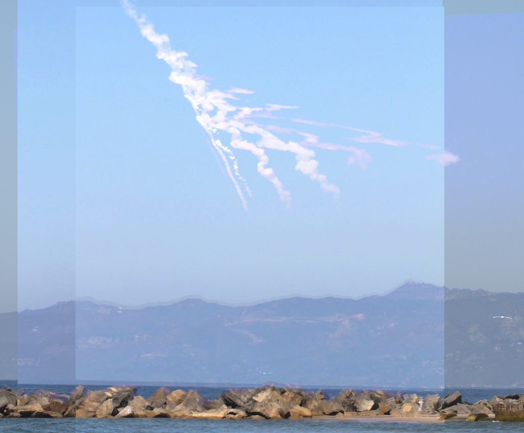
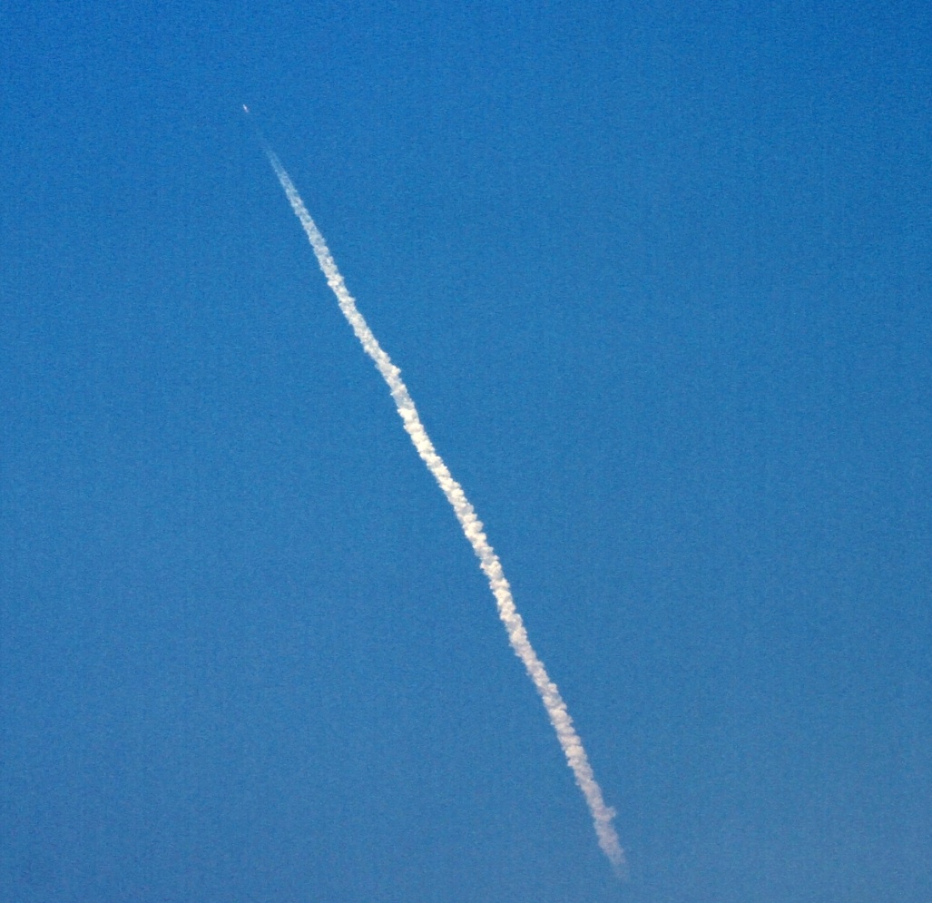
The fuel for this massive rocket is pure hydrogen and oxygen. Meaning it will make a contrail of pure water (no exhaust particulates required). It will be visible from all over Southern California, and maybe some of Nevada. Here's the last one from Orange County (south of LA)

I'll post updates in this thread, and then see if there's any fallout from people spotting the trail, and thinking it's suspicious.

[Update]
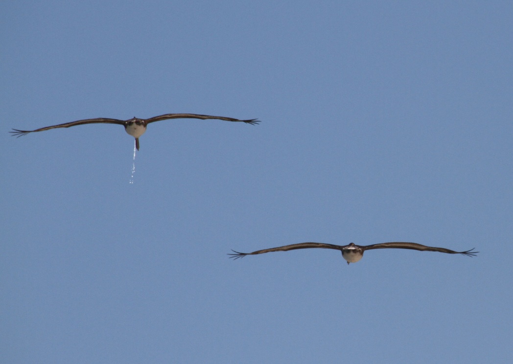
Here's one of my better photos. More below.
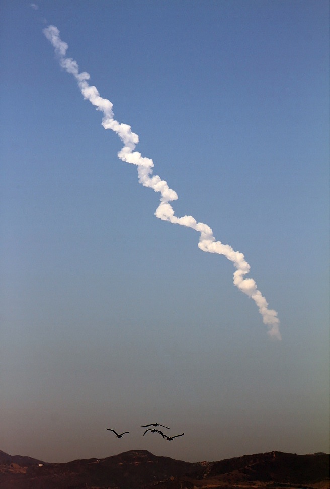
 
Last edited:
About 15 minutes from launch as I type. The latest radiosonde data out of VAFB shows RH dropping to <50% at around 700 meters (2300 feet). -40C and below temps begin at around 10900 meters (36000 feet) however RH is only around 9%. I'm guessing there will be enough water vapor generated to produce at least a short lived contrail beginning somewhere around typical jet cruising altitudes.

http://weather.uwyo.edu/cgi-bin/sou...AR=2013&MONTH=08&FROM=2812&TO=2812&STNM=72393
 
That was very cool to watch...I did see a glimpse of a contrail in one of the shots....

but it seemed like the launch generated a pyroclastic flow :D
 
That was very cool to watch...I did see a glimpse of a contrail in one of the shots....

but it seemed like the launch generated a pyroclastic flow :D
Here's the view from Bolsa Chica in Orange County
image.jpg
 
Last edited by a moderator:
I was impressed by the fireball at ignition. Seems like a lot of transient hydrogen around the base. Also, it appeared there was some flame around the edges of the base as it initially climbed out. Seemed strange.
 
The view from Venice Beach. You can just see the rocket in this one:


A bit later.


Much later

 
Last edited:
Surely that spiral shape is not anything random? I don't think the rocket is spinning but are they vector ing thrust all the time? It's just so perfect!
 
Also coincidentally got this illustrative photo: a different type of emission illustrates how falling liquid breaks up into drops of a certain minimum size.

 
Last edited:
That's awful. I wonder if they monitor the position of their fellow birds before they do that?

And if it is windshear that makes that, I'm impressed.
 
Nice photos.

I'll post updates in this thread, and then see if there's any fallout from people spotting the trail, and thinking it's suspicious.

I wonder if that combined with the classified payload will cause any online freakouts.
 
Surely that spiral shape is not anything random? I don't think the rocket is spinning but are they vector ing thrust all the time? It's just so perfect!

The first Stage of a Delta IV Heavy has three identical Engines...


During flight the Engine in the middle runs only with 60% Power, the 2 Engines besides are running full power, so the engines on the side are running out of fuel earlier and can be seperated when empty.

This could results in some strange vortex-phaenomena, but this is speculation by me. I allways look on the Rocket, not the trail ;)
 
Last edited by a moderator:
Very cool, Mick. GF wants me to tell you "Awesome picture".

Any estimates on altitudes of where the contrail starts and stops? Looks like a good example of a contrail starting at altitudes where temps drop below -40 C and ending in the stratosphere where aerosol and water vapor density dramatically decrease. All in all I'd say it's excellent evidence that aerosols from jet engine exhaust are NOT required to produce condensation trails.

On a technical note, that Delta IV heavy was burning over 4,000 pounds of propellent per second (liquid oxygen and liquid hydrogen), which means over 240,000 pounds of water vapor was expelled into the atmosphere for every minute of flight.
 
Nice shots, Mick. I was working and lost track of the time. I caught this at about 11:15 from Northeast Bakersfield. I was really looking forward to the launch.

Rocket0714.jpg
 
Very cool, Mick. GF wants me to tell you "Awesome picture".

Any estimates on altitudes of where the contrail starts and stops? Looks like a good example of a contrail starting at altitudes where temps drop below -40 C and ending in the stratosphere where aerosol and water vapor density dramatically decrease. All in all I'd say it's excellent evidence that aerosols from jet engine exhaust are NOT required to produce condensation trails.

On a technical note, that Delta IV heavy was burning over 4,000 pounds of propellent per second (liquid oxygen and liquid hydrogen), which means over 240,000 pounds of water vapor was expelled into the atmosphere for every minute of flight.

This is a little back of the envelope, but sounding from Oakland airport at 12z http://www.weatheronline.co.uk/cgi-...BASE=-&VAR=temps&LKEY=CA&HH=3&ARCHIV=0&SHOW=1 shows environmental temperature drops below -40 at around 33000 ft.
Doesn't appear to be any fronts around the west coast so should still be a reasonably representative air mass, although continental USA is not my area of expertise.
Dewpoint is around -50 c at that altitude, but I can't remember how to easily calculate relative humidity manually (normally a computer does it for me when I hover my mouse over a sounding), will see if I can dig out my training notes....
 
Very cool, Mick. GF wants me to tell you "Awesome picture".

Any estimates on altitudes of where the contrail starts and stops? Looks like a good example of a contrail starting at altitudes where temps drop below -40 C and ending in the stratosphere where aerosol and water vapor density dramatically decrease. All in all I'd say it's excellent evidence that aerosols from jet engine exhaust are NOT required to produce condensation trails.

Hard to say exactly . The launch site is 130 miles away. It starts about 2 degrees above the horizon, and stops at 5 degrees. Simple geometry says that's 24,000 to 60,000 feet. But with the curvature of the earth, it's probably more like. 30,000 to 70,000 feet.
 
Also coincidentally got this illustrative photo: a different type of emission illustrates how falling liquid breaks up into drops of a certain minimum size.

I'll bet you couldn't repeat that shot no matter how hard you tried :)
 
Last edited by a moderator:
Also the -40 rule of thumb assumes a modern jet engine. A rocket engine may well be different
 
This is a little back of the envelope, but sounding from Oakland airport at 12z http://www.weatheronline.co.uk/cgi-...BASE=-&VAR=temps&LKEY=CA&HH=3&ARCHIV=0&SHOW=1 shows environmental temperature drops below -40 at around 33000 ft.
Doesn't appear to be any fronts around the west coast so should still be a reasonably representative air mass, although continental USA is not my area of expertise.
Dewpoint is around -50 c at that altitude, but I can't remember how to easily calculate relative humidity manually (normally a computer does it for me when I hover my mouse over a sounding), will see if I can dig out my training notes....

Pretty much. Here's my first post with soundings from 12 Z today out of Vandenberg AFB itself:

About 15 minutes from launch as I type. The latest radiosonde data out of VAFB shows RH dropping to <50% at around 700 meters (2300 feet). -40C and below temps begin at around 10900 meters (36000 feet) however RH is only around 9%. I'm guessing there will be enough water vapor generated to produce at least a short lived contrail beginning somewhere around typical jet cruising altitudes.

http://weather.uwyo.edu/cgi-bin/sou...AR=2013&MONTH=08&FROM=2812&TO=2812&STNM=72393

The atmosphere was pretty dry above just a few thousand feet on up so that 4,000+ pounds of water vapor per second into a cold dry atmosphere is a good demonstration of how just water vapor exhaust, albeit a tremendous amount, and naturally existing aerosols already present in the atmosphere is all it takes to make a persistent condensation trail. No aerosols in the exhaust required.
 
Hard to say exactly . The launch site is 130 miles away. It starts about 2 degrees above the horizon, and stops at 5 degrees. Simple geometry says that's 24,000 to 60,000 feet. But with the curvature of the earth, it's probably more like. 30,000 to 70,000 feet.

Hey Mick, since we have photos from 2 angles, Bakersfield and LA, if we have exact coordinates and elevation of where you and I were both standing when we took the photos, could a more accurate estimate be made?
 
Here's some video showing the trail forming, the contrail portion lasts around 28 seconds. There's also a nice edge shadow.
 
Hey Mick, since we have photos from 2 angles, Bakersfield and LA, if we have exact coordinates and elevation of where you and I were both standing when we took the photos, could a more accurate estimate be made?

It would probably be easier to do it based on video timing and the mission altitude info. It's hard to get an accurate elevation angle in the 2 degree range.
 
Pretty much. Here's my first post with soundings from 12 Z today out of Vandenberg AFB itself:


The atmosphere was pretty dry above just a few thousand feet on up so that 4,000+ pounds of water vapor per second into a cold dry atmosphere is a good demonstration of how just water vapor exhaust, albeit a tremendous amount, and naturally existing aerosols already present in the atmosphere is all it takes to make a persistent condensation trail. No aerosols in the exhaust required.

Ah, didn't see sounding data was available from the site!

The unknown quantities that will affect the formation temperature (and hence altitude) are the amount of vapor emitted in the exhaust and the temperature of the exhaust gases. Environmental humidity only matters in determining if it will persist.
 
We just had a night launch of one on the seventh of Aug . Spectacular at night , Unlike the shuttle it appeared to heading south instead of up . I guess because it was going into low earth orbit ? Lots of UFO reports and strange clouds . However it was just a rocket (Wideband Gapfiller Satellite) payload . Lots of money for defense ?
 
Ah, didn't see sounding data was available from the site!

The unknown quantities that will affect the formation temperature (and hence altitude) are the amount of vapor emitted in the exhaust and the temperature of the exhaust gases. Environmental humidity only matters in determining if it will persist.

Well, Combustor Temperature is 3600 K. The guy on the live feed giving a "play-by-play" of the launch said the rocket was burning over 4,000 pounds of pure hydrogen and oxygen propellant every second so I'm assuming there's over 4,000 pounds of water vapor created per second.

Combustor temp on pg. 34
http://digitalcommons.usu.edu/cgi/v...h="delta IV heavy RS-68A exhaust temperature"

Also see:
http://www.spaceflight101.com/delta-iv-heavy.html
 
Wow, really cool. I'd love to see this in person one day. I don't think I'll ever forgive myself for missing the last shuttle launch.

Joe said:
Unlike the shuttle it appeared to heading south instead of up . I guess because it was going into low earth orbit ?

The shuttle only went into LEO(in fact, no manned spaceflight outside of the Apollo program has ever gone beyond LEO). It also did a rotation maneuver during launch, turning away from "straight up" from the ground. The direction does determine the orbit though. It really all does come down to what perspective you're viewing it from - far enough from the launch site it will appear to be going "up".
 
Wow, really cool. I'd love to see this in person one day. I don't think I'll ever forgive myself for missing the last shuttle launch..

The best way to see one is from the upper flight levels near the launch. The shuttle comes up from below you and very rapidly rises above you. The clear air up there lets you watch it for much longer than down below. And the ever changing relative position gives you a different, three dimensional perspective on it. Plus you get to be involved with the flight diversions around the launch area. The only thing you miss is the sound. I've seen two like that. The passengers really love it too.
 
The passengers really love it too.

Something I always wondered, do you ever have to adjust trim because lots of passengers are moving to one side if the plane? I've wondered if they simulate an event like that with ballast barrels.
 
We just had a night launch of one on the seventh of Aug . Spectacular at night , Unlike the shuttle it appeared to heading south instead of up . I guess because it was going into low earth orbit ? Lots of UFO reports and strange clouds . However it was just a rocket (Wideband Gapfiller Satellite) payload . Lots of money for defense ?

The Gapfiller satellites are in a geostationary orbit, which is at an altitude of a little more than 22,000 miles directly above the equator. To get to an equatorial orbit from FL would require heading south. Low Earth Orbit only goes up to an altitude of about 1,200 miles. The NROL-65 launch from Vandenberg put a satellite into a low earth polar orbit, which is why it went on a southwest heading. A polar orbit would indicate NROL-65 is some sort of military surveillance satellite. The Aqua and Terra satellites are also in a polar orbit. All heavy rockets have to initially go straight up until enough velocity is achieved to maneuver.

http://www.spaceflight101.com/delta-iv-heavy-nrol-65-launch-updates.html

http://www.fas.org/spp/military/program/com/wgs.htm

http://psbcw1.nesdis.noaa.gov/terascan/home_basic/polar-info.htm

http://psbcw1.nesdis.noaa.gov/terascan/home_basic/polar_sats_overview.htm

http://marine.rutgers.edu/mrs/education/class/paul/orbits2.html
 
Back
Top