Claim: 146 Mile Microwave Transmission Proves Flat Earth

Nth

Member
Hello everyone, first post here, hope I do everything correctly. (Moderators, please feel free to edit as needed.)

Anyway, flat earthers have recently latched onto a microwave transmission achievement by Exalt Wireless as proof that earth is flat. In 2016, the company managed to make a link over 235 kilometers, ranging:

"...between an island in the Mediterranean and the coast of Lebanon..."

This was apparently achieved without repeaters, providing a direct connection from point A to point B.

Source: https://finance.yahoo.com/news/exalt-sets-world-record-microwave-130500366.html

Now, the flat earth claim stems from a YouTube comment which states as follows:

"Here’s a real world flat earth proof. Exalt Wireless has a product called ExploreAir which is a LINE-OF -SIGHT microwave transmission platform. This is a recent press release about a recent installation over water from Beirut to Cyprus. You can skip to the last paragraph and not bother reading it if you like. I had to put it here or the globetards would demand to see it. This product is a line-of-sight microwave link which is basically a straight line over water (The Mediterranean Sea) to a receiver on the other end, 150 miles away. There should be three miles of curvature but this LINE-OF-SIGHT connection is mounted at less than fifty feet on both ends. I spoke to them today to confirm this and didn’t bring up the reason why. I told them I was just impressed with their accomplishment and wanted to learn about the equipment and the installation. It is as advertised, a straight line over 235km of water, point to point, no repeaters. Again, skip to the last paragraph unless you’re technical and interested."

Source: https://www.thedailyplane.com/world-record-shows-evidence-for-a-flat-earth/

The claim by the flat earther is that the transmitter and receiver are both only mounted 50 feet above sea level, despite the fact that I have been unable to verify this number with Exalt's published materials, which leaves the origin of the 50 feet number in question. Indeed, Exalt's own website notes:

"An impressive and popular range claim is 124 miles. The reader will discover that no assumptions are provided to support such claims. Such a range truly would be impressive if it did not require the use of two 2000 foot (600 meter) towers in order to clear the Earth’s curvature."

2b704d2e-6172-41bb-bcc1-4658b84cbb61.jpg

Source: http://www.exaltcom.com/How-Far-Will-It-Go.aspx

My point in posting this here is to see if anyone can verify the flat earther's claim, or if, to put it politely, he/she is simply blowing smoke and the transmitters and receivers can be verified to have actually been tall towers situated atop mountains, such that curvature is accounted for as described on the Exalt website linked posted above. I figure that the latter option is the correct one, but I want to do my due diligence (besides, with how this claim is spreading, it would probably wind up here anyway).

Thanks in advance.
 
Last edited by a moderator:
My point in posting this here is to see if anyone can verify the flat earther's claim, or if, to put it politely, he/she is simply blowing smoke
based on his graphic and bolded text,
0.jpg

he seems to be under the impression that 'across water' and "coast of Lebanon" means ONLY across water. But the coast of Lebanon is pretty mountainous.
x.png


cyprus.JPG

and the Company's press release explains (to me) what "over water means" vs. full overland.

"We have said all along that our microwave systems deliver the highest performance and reliability, and this deployment proves it," said Amir Zoufonoun, CEO and founder of Exalt Wireless. "We believe that the previous distance record was 225 kilometers, and that was over land, using dual radios at each end of the link. Our deployment uses just one radio at each end of the link and we link over water, which creates significant transmission problems for ordinary microwave radios." http://www.exaltcom.com/pressRelease.aspx?id=4256
Content from External Source

@Nth I'm not seeing anything in English searches, perhaps it would be easier to write the company and ask where their towers are located. Link them to the Flat Earth claims though or they might think you're a terrorist wanting to blow up their tower.
 
Last edited:
Isn't there a formula/calculation that can confirm at what height 2 towers need to be in order to see line of sight at 235km apart taking the earths curvature into account?
 
Man I'm confused. I was going to ask where does Exalt claim they got 124miles (235km's) because the Yahoo article doesn't give references other than quoting the CEO and then listing the Exalt website at the end. But when I searched for ExploreAir LR 7 on the website I found the press release that is a copy of the Yahoo link word for word (or visa versa): http://www.exaltcom.com/pressRelease.aspx?id=4256&terms=ExploreAir+LR+7.

But when I read the link in the original post Exalt seem to say the opposite that 124miles is a myth:


Your Radio Can Go How Far!?
A common technique that vendors use to claim greater range is to conveniently ignore throughput availability and instead focus only on link availability. This approach is indeed convenient, as it allows these vendors to make just about any range claim they wish, as they guarantee only a connection.

An impressive and popular range claim is 124 miles. The reader will discover that no assumptions are provided to support such claims. Such a range truly would be impressive if it did not require the use of two 2000 foot (600 meter) towers in order to clear the Earth’s curvature. Assuming that small hurdle could be overcome – if the radios were operating in space, for example – then many microwave radios, including Exalt radios, could communicate at this distance, assuming adequately sized antennas and no requirements for throughput or throughput availability.

But such impractical range specifications are of little use to a microwave professional trying to determine whether a microwave system can deliver 100 Mbps of guaranteed user throughput across a link at 99.999% availability. That’s why you won’t see Exalt quoting a 124-mile range and why Exalt range specifications always include realistic underlying assumptions.

Remember: if it sounds too good to be true, it probably is.

Specifying Range
Exalt provides range specifications in a format similar to the table below:

See link for table as it won't paste properly here
Content from External Source
Source: http://www.exaltcom.com/How-Far-Will-It-Go.aspx

1) am I reading it wrong and they're saying they did it by having 600m towers?

or

2) are they saying you would need 600m towers and it's a myth?

Someone please set me straight.
 
Isn't there a formula/calculation that can confirm at what height 2 towers need to be in order to see line of sight at 235km apart taking the earths curvature into account?

Is this the calculation:


Geometric distance to horizon[edit]

R is the radius of the Earth, h is the height of the transmitter (exaggerated), d is the line of sight distance
Assuming a perfect sphere with no terrain irregularity, the distance to the horizon from a high altitude transmitter (i.e., line of sight) can readily be calculated.

Let R be the radius of the Earth and h be the altitude of a telecommunication station. The line of sight distance d of this station is given by the Pythagorean theorem;

{\displaystyle d^{2}=(R+h)^{2}-R^{2}=2\cdot R\cdot h+h^{2}}[Broken External Image]:https://wikimedia.org/api/rest_v1/media/math/render/svg/ceeee52879665f37b508a8d4117b6383ad9fd114
Since the altitude of the station is much less than the radius of the Earth,

{\displaystyle d\approx {\sqrt {2\cdot R\cdot h}}}[Broken External Image]:https://wikimedia.org/api/rest_v1/media/math/render/svg/b6f1cd861587b50ec2933ef8a5008fc15c84402c
If the height is given in metres, and distance in kilometres,[2]

{\displaystyle d\approx 3.57\cdot {\sqrt {h}}}[Broken External Image]:https://wikimedia.org/api/rest_v1/media/math/render/svg/0cc87b5e8d57b9866c3fa595e57bdddf51d2b545
If the height is given in feet, and the distance in miles,

{\displaystyle d\approx 1.23\cdot {\sqrt {h}}}[Broken External Image]:https://wikimedia.org/api/rest_v1/media/math/render/svg/95319b9bec4e18bb943cd3890688571f61c2d984
Content from External Source
Source: https://en.wikipedia.org/wiki/Line-of-sight_propagation#Geometric_distance_to_horizon

Please note the quoted text above doesn't show the formulae as they're pictures on the wiki page, so you may have to click the source link provided to see the them.
 
Isn't there a formula/calculation that can confirm at what height 2 towers need to be in order to see line of sight at 235km apart taking the earths curvature into account?

Doing simply with geometry is misleading, but.

Distance to horizon is sqrt(h^2 + 2rh), so for equal height towers

2*sqrt(h^2 +2rh) = 235, and r=6371

Gives h of about 1 km.
 
235 km is 146 miles.
that page is almost 9 years old, at least. so perhaps back then people weren't getting 124 miles. ??
upload_2018-2-27_0-46-47.png

Sorry I was switching between both articles and mixed up my numbers.

Ah. This is why I got confused. There's no date on the 'How far will it go?" article so I didn't realise it was 9 years old. So 9 years ago it was impossible, but now (actually 2016) it was finally achieved?
 
Mick are you able to do the calculation? Even though I understand BODMAS, I'm still too stupid to do the calculation :(

It's a bit confusiong as they switch between h in miles and h in feet (or km/m)

d = sqrt(2*k*R*h) is a valid approximationwith everything in the same units


d = 1.41*sqrt(h) has d in miles, h in feet
1.41 is sqrt(2*(4/3)*3959/5280), with the /5280 correcting for the h in feet

What's the question again :) ?
 
Thank you all for taking up this topic. Flat earthers are spreading this idea in various comment threads and social media channels.

I have asked flat earthers if they can verify the 50 feet claim by anything other than an anonymous YouTube comment, and I get no replies.
 
Playing with the Metabunk curve calculator, you would only need land a fraction over 3000ft (900 metres) at each end to get the line of sight. (Horizon is 72.5 miles away from 3000ft, with refraction.)

Looking at the Google Maps terrain view, it's possible to find two points both over 900 metres above sea level, separated by 146 miles, one in Cyprus and one in Lebanon. So you wouldn't even need a tower, in theory, just a transmitter on the ground.

upload_2018-2-27_16-36-30.png

Close-ups of either end:

upload_2018-2-27_16-38-43.png

upload_2018-2-27_16-39-32.png


I'm not suggesting these are the actual locations, of course, just showing that it is trivially easy to find locations in Cyprus and Lebanon that have a line of sight of 146 miles between them.
 
Last edited:
Further confirmation that there is a line of sight from Cyprus to Lebanon:


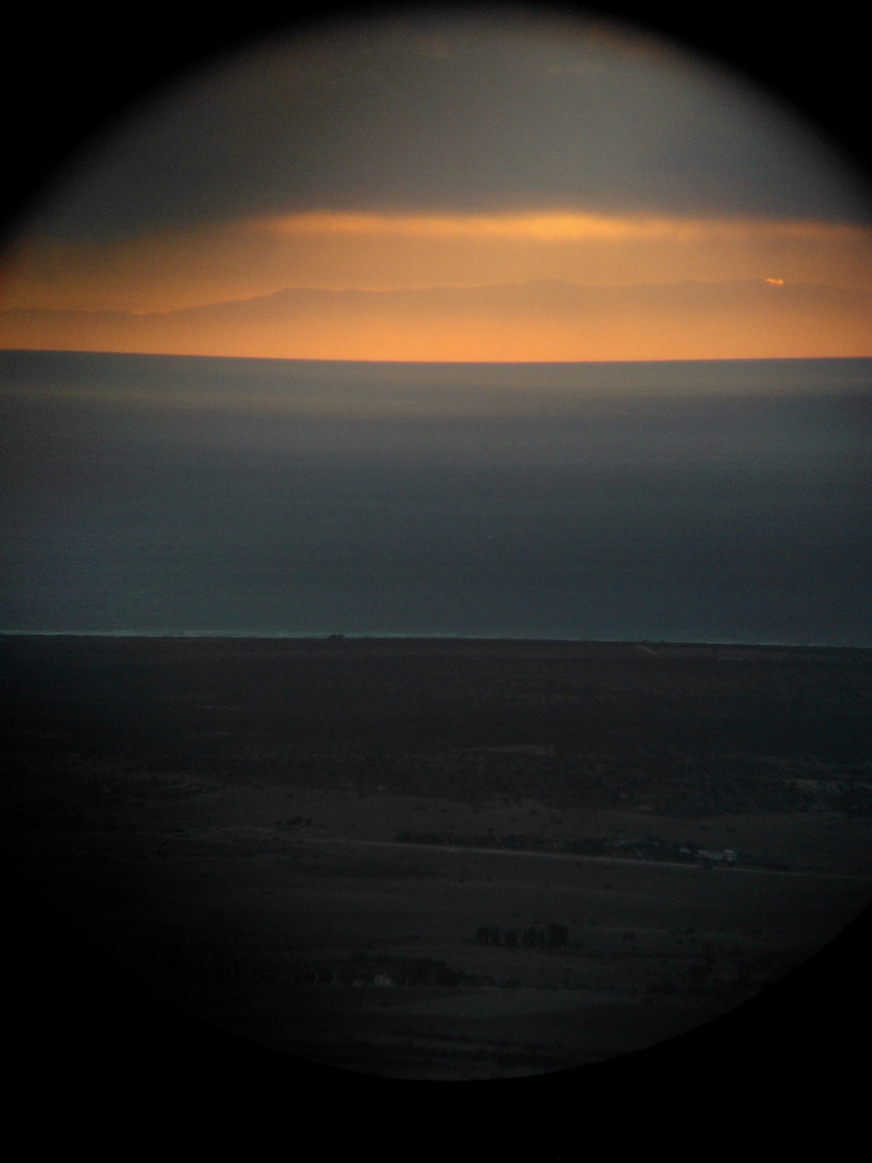
Yes, you can see Lebanon from Cyprus, but once in a lifetime if you are lucky! I took this photograph of the mountains of Lebanon from Kantara castle (Cyprus) very early on a very cold morning. I simply stuck the camera of my mobile to my binocular. Note: Cyprus countryside and coast in foreground.

The visibility was... beyond belief! I could see very clearly, to the naked eye, the Taurus mountains and the Turkish coast (even big buildings there, with my bare eyes), the mountains behind Iskenderun, the mountain of northen Syria, all the Syrian coast and the mountains of Lebanon until not far from Israel.
Content from External Source
From: https://travel.stackexchange.com/a/99012

And here is a map of the "visibility cloak" from that point. Note the red shading on lots of mountains in Lebanon: https://www.heywhatsthat.com/?view=NI7FLWDV

upload_2018-2-27_18-31-12.png

Simulated panorama: circled peaks are in Lebanon.

upload_2018-2-27_18-33-25.png
 
Last edited:
Apologies for somewhat disappearing from this thread, school's been busy over the past few days.

Anyhow, thanks to everybody for the responses. I'll probably send off an email to the company regarding how exactly the towers are positioned (sounds like this is effectively a permanent link, rather than some proof of concept thing), re: @deirdre's suggestion.

Two things I've been looking at in the meantime, though. First, tropospheric scattering, which I've learned used to be quite common practice before the widespread use of satellites: https://en.wikipedia.org/wiki/Tropospheric_scatter

Relevant information:

"Tropospheric scatter (also known as troposcatter) is a method of communicating with microwave radio signals over considerable distances – often up to 300 kilometres (190 mi), and further depending on terrain and climate factors."

That would be my best guess in the case of the towers indeed being verifiably 50 feet above sea level. However, once again, I haven't found anything to suggest that the 50 foot claim is even true. On that subject, for two, what I have found are a few sites that log photos of radio and TV masts in Cyprus, none of which look to be even close to just 50 feet above sea level. Sorry for the links, I hope this isn't an issue with the no-click policy; the sites aren't letting me open images in a new tab to link directly.

http://www.mds975.co.uk/masts/cyprus.html

http://www.simonmason.karoo.net/page496.htm

Point being, it looks like these towers are designed to be as tall as possible, to transmit as far as possible under typical conditions.
 
Following up on the last post, I have found some well-documented information on a 193 km microwave link from Honduras to Roatan Island. Describing the set-up:

In this design, Site A, “Las Cruces,” is at 1600 meters above mean sea level and Site B, “Dixon Hill,” at 250 meters on Roatan Island. The reflections and delay were optimally neutralized with precise antenna spacing and up-tilt.

Source: http://blog.aviatnetworks.com/from-the-field/the-worlds-longest-all-ip-microwave-link/

Seems like this was a former longest direct link, perhaps supplanted by Exalt Wireless's new record. The plus side to analyzing this is that we have published information on the elevations at both ends of the link. Using the Metabunk earth curve calculator, with 193 km for the distance and 1600 meters for the height:

Distance = 193 km (193000 m), View Height = 1.6 km (1600 m) Radius = 6371 km (6371000 m)

Results ignoring refraction
Horizon = 142.79 km (142792.72 m)
Bulge = 730.87 meters
Drop = 2.92 km (2924 m)
Hidden= 197.83 meters
Horizon Dip = 1.284 Degrees, (0.0224 Radians)


With Standard Refraction 7/6*r, radius = 7432.83 km (7432833.33 m)
Refracted Horizon = 154.23 km (154232.38 m)
Refracted Drop= 2.51 km (2506.13 m)
Refracted Hidden= 101.1 meters
Refracted Dip = 1.189 Degrees, (0.0207 Radians)


So, even if refraction were totally ignored, this situation still has a line of sight by over 50 meters. Honestly, seeing stuff like this, as well noting repeated references to the curvature of the earth in literature on the subject of long-range transmission, suggests to me that the comment referenced in the OP is leaving some crucial information out. Besides, like @Z.W. Wolf points out, there are many points on Cyprus and Lebanon within the 235 km window with sufficient elevation to peek over the earth's curvature if the 50 foot number is incorrect.
 
Thank you all for taking up this topic. Flat earthers are spreading this idea in various comment threads and social media channels.

I have asked flat earthers if they can verify the 50 feet claim by anything other than an anonymous YouTube comment, and I get no replies.

No problem; was on one of George Hniatuk's videos when someone posted a comment linking to a mirror of the video. Seemed like such an extreme claim that I had to look into it. I'm still doing some research on the subject, but it seems that no one's been able to confirm the 50 foot number. YouTuber Paul on the Plane mirrored the video, but there are a number of people in the comments section (some flat earthers included) who are questioning this claim, and at least one guy is saying that he's found the coordinates of the towers in question on Cyprus's end. I'll reference that if it winds up panning out.

Adding an additional wrinkle to the plot is this image headlining an article on the record:

[Broken External Image]:http://www.cloudwedge.com/wp-content/uploads/2016/02/Microwave-Link.jpg


Source: http://www.cloudwedge.com/exalt-wireless-shatters-world-record-for-microwave-link-distance-235974/

If those towers pictured above are indeed the ones used for this record, then we can kiss the 50 foot claim goodbye, unless, you know, those are small-scale toy mountains in the background.
 
Last edited:
If those towers pictured above are indeed the ones used for this record, then we can kiss the 50 foot claim goodbye, unless, you know, those are small-scale toy mountains in the background.

I'm pretty sure that is just a stock image. From Tineye:

upload_2018-3-1_13-11-55.png
 
I had a 'conversation' with a flat-Earther that has worked with a few long-range wireless installations. Naturally, he claimed the Earth is flat, and his wireless links actually penetrate Earth's curvature if we were to use the spherical Earth model.

I found the best response to this is to demand the coordinates and the height of the towers. And it would check out every single time.

Various vendors of long-range Wi-Fi equipment provide link planning tools to automate calculation. They account for distance, surface topology, the width of Fresnel zone, the height of the towers and obviously, the curvature of the earth, in order to determine if a link is viable.

Some of the planning tools are listed below. Some require free registration (pretend you are interested in their products).
This hasn't been mentioned before, but line of sight alone is not enough. The link also needs to clear its Fresnel zone as much as possible. It doesn't have to be 100% free from obstruction, but the more of the Fresnel zone is obstructed, the lower the signal quality. Image from Wikipedia:

800px-FresnelSVG1.svg.png

This is a hypothetical 238 km wireless link from Lebanon to Northern Cyprus (permalink to Ubiquiti's planning tool). And it would work according to the link planning tool.


1.png
 
According to that link about cyprus to Lebanon visibility, there was a picture showing it was visible.

However, the claim was that you might be able to see it “once in a lifetime.”

Considering many objects stop microwaves, would that not destroy the signal too then if the atmosphere is too dirty to be able to see there?
 
Also in regards to the previous record distance it is stated that there is line of sight by 50 meters.

If that is the case then would atmospheric refraction often mess up the rays by more than 50 meters?

Over that massive distance I would assume that there would be a lot of disconnections due to atmospheric refraction if the height is only cleared by 50 meters.
 
This a great representation of the cherry picking of facts and science that they use. Referencing something as evidence of Flat Earth despite data from the company that discusses the curvature of the earth? The dishonesty and hypocrisy never ceases to amaze me
 
Oops, violated the no-click. My bad. First timer. I'm just going to try and articulate a point here based on the information I've found. So Exalt wireless is the maker of the microwave radios, but they are not the operators. It's most likely that they don't even install or set them up, based on these facts; on their website, they explain that several companies distribute their products. Also on their site, as well as pdf downloadable, are instructions on how and under what conditions to install the hardware, and examples of ideal weather conditions along with troubleshooting. Several wireless internet providers advertise microwave connection from Cyprus to Beirut, such as Cyberia, WISE and Sodetel. They never mention Exalt by name. Exalt themselves do not offer any wireless services, as far as I can tell. So to this effect, I find it highly unlikely that "Joe Mama" was able to contact Exalt and verify the heights of the towers in question. I even continued to trace the WISP's back to the satellite base in Cyprus, known as Makarios Teleport. No mention of exalt, no height specs, however there are a couple pictures of said base and even a YouTube video in English, made by Cyta Global (Cyta, aka Cyprus Telecommunications Authority, is the operator of Makarios and the central communications hub that links Beirut to internet and other telecomms via France). Their website shows C-ban microwave satellites at their base that operate in the same frequency ranges as what's claimed by Exalt. Even Cyta does not mention tower heights and will not give their exact coordinates. So my point in all of this is not that "absence of evidence is evidence of absence." My point is that Joe Mama's credibility is extremely flawed due to the fact that he never mentioned any of these sources, never claims to have contacted anyone who would actually know the elevations of these microwave radios, yet makes a very questionable claim using an unreliable source who wouldn't be involved in the installation of the equipment in the first place.
 
My point is that Joe Mama's credibility is extremely flawed due to the fact that he never mentioned any of these sources, never claims to have contacted anyone who would actually know the elevations of these microwave radios, yet makes a very questionable claim using an unreliable source who wouldn't be involved in the installation of the equipment in the first place.

If Exalt is aware of the record-setting.. which it is, since they released the press report. I'm sure they know which service provider towers managed it.

Joe Mama's credibility is extremely flawed because the earth is not flat, ergo the towers can't be 50' above sea level. and Exalt's own literature shows the curve of the Earth in calculations.
I agree with you, however, Joe Mama's claim is that the tower height and distance is evidence of a flat earth. Therefore I thought it to be more important to address the "evidence" at hand, rather than just stating "the earth is not flat." That wouldn't necessarily debunk the person's claim about the specifics. If there were in fact 50ft towers producing a line-of-sight connection, it would be worth finding out how that's possible, to show exactly why it does not constitute evidence for a flat earth. But my contention is that he's lying about ever having contacted them. I also agree that they most likely know where the radios are mounted, but the context in which it's written, "...what it believes to be a record breaking 235 km..." can be construed to either mean they believe the distance is a record breaker, or that they believe 235km is the distance in question. In the former context, according to Singer Executive Development, they would be wrong. According to Singer's report, Telettra did a longer hop over water in 1979. Quoted from the article (titled, "The World's Longest Microwave Radio Link"), "This record setting link was 360 km long and crossed the Red Sea over a good part of its path connecting Jebel Ebra, Sudan with Jabal Dakka, Saudi Arabia." http://www.singerexecutivedevelopment.com/the-worlds-longest-microwave-radio-link/
That strengthens the argument that Exalt may in fact be mistaken or misinformed about some or all of their information, and it may be due to the possibility that they were given incomplete or incorrect third-party information. We know the earth is not flat, but that does not prove that 50ft towers cannot somehow produce a line of sight connection across such a distance. Microwave rays are electromagnetic, and can be refracted by the atmosphere. Although I do not believe Mr. Mama, I find it important to debunk (or otherwise confirm, and henceforth find a realistic explanation to,) his claim, thereby eliminating the misconception that it would "prove flat earth."
 
This is an old topic, but please allow an addition:

Radio wave refraction in the atmosphere is not the same as optical wave refraction. Radio waves go a little beyond the optical horizon. Practically, as a rule of thumb, microwave engineers calculate the effective radius of the Earth as 4/3 of the physical radius. This shows that even when optical line of sight is nonexistent, radio line of sight can be possible.

http://glossary.ametsoc.org/wiki/Effective_earth_radius

In radar and radio propagation studies, a value for the radius of the earth that may be used in place of the actual radius to correct for refraction by the atmosphere. [...] Moreover, because n varies with frequency, so does the effective earth radius. The index of refraction of the atmosphere ordinarily decreases with altitude so that radar or radio waves that are transmitted horizontally are refracted downward. The radius of curvature of the propagating rays depends on the vertical gradient of the refractive index. For standard refraction conditions, the effective earth radius is 4/3 times the geometric radius.
Content from External Source
In the good old days this was done by using a special curved lined paper, plotting the prominant land features over the curved lines and drawing the radio propagation path in a straight line. The link below will show such a plot, which I also embedded as a picture.

36-Figure2.5-1.png

https://www.semanticscholar.org/pap...82d3d95f1e7064e34e4391eb844de34a4c3e/figure/7

Nowadays, with computer simulation, it is possible to plot the land as a real section of the Earth and drawing the propagation path as a refracted, curved line.

With correct radiometeorological data (historic averages), it is possible to use actual refractive index instead of 4/3. Practically, the engineer calculates with both, and selects the one which provides grater availability (that is, higher towers).
 
Last edited:
Back
Top