A Single Thick Solitary Trail

Marin B

Active Member
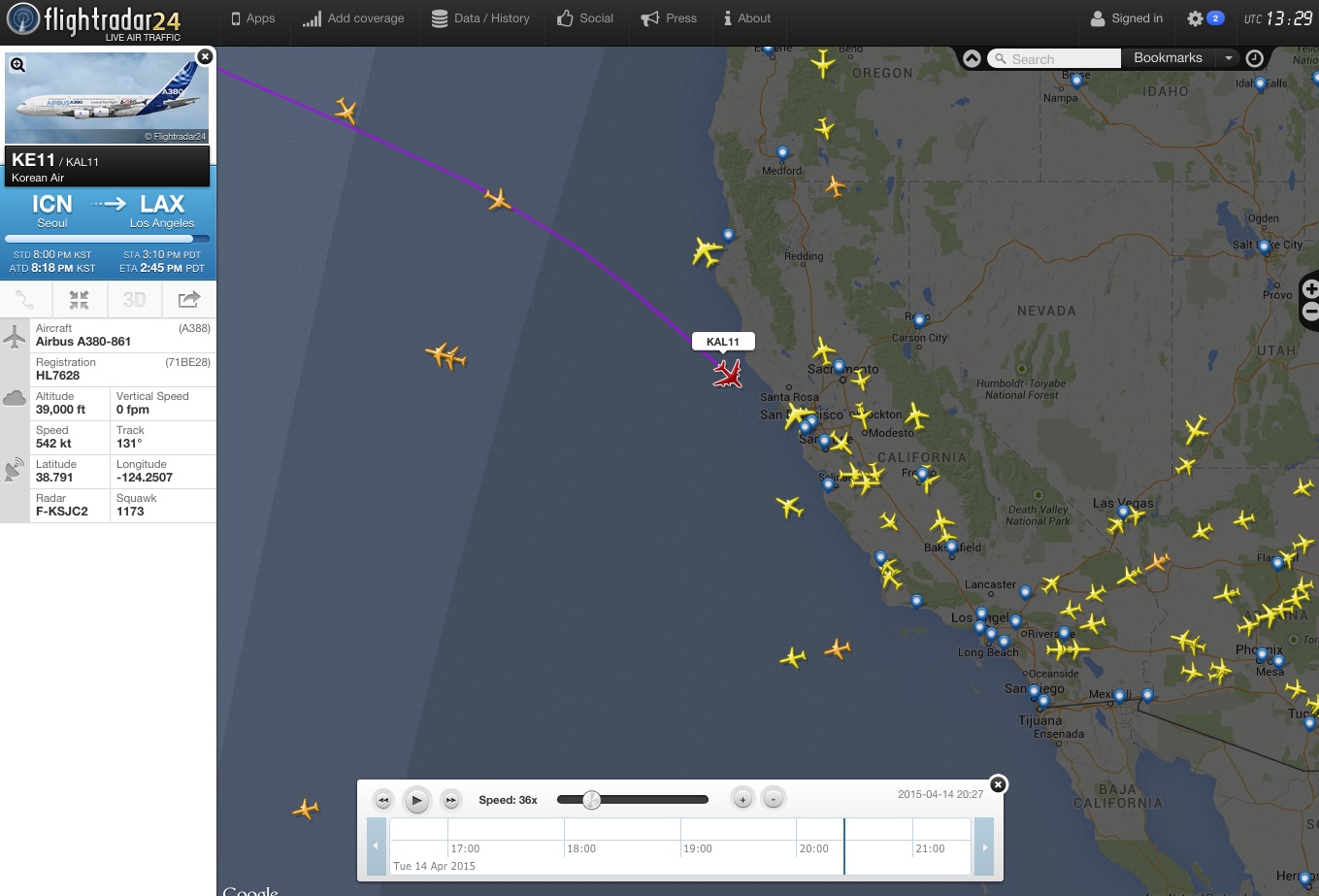
I haven't had a chance to spend much time on this site yet, and so perhaps the answer is already here somewhere... By way of background, I live/work in the San Francisco Bay area where there are several busy airports. Also, having recently purchased the FlightRadar24 app, I've learned that several Hawaiian bound flights from the East & Midwest fly over S.F., as well as LAX-bound flights from Asia, Seattle, and Anchorage. So typically when there are contrails, there are a lot that often result in the milky white skies that a family member would like to convince me to believe is the result of government spraying.

Yesterday where I work the skies were completely blue, with the exception of a single contrail from a large jet - maybe a 747, flying very high (amateur guess is close to 40,000 ft.) in what I think was a NW to SE direction. I got out my flight tracker app, but the jet didn't show up at all. It formed the only persistent contrail I saw during the 1-2 hour time span that I was periodically looking out my office window. In fact, I didn't see any other contrails at all. Whereas this one contrail was thick and spread out to form a big band across the sky. So my question is what can explain that? Is it possible to have only a very narrow altitude range that results in persistent contrail formation?
 
Yesterday where I work the skies were completely blue, with the exception of a single contrail from a large jet - maybe a 747, flying very high (amateur guess is close to 40,000 ft.) in what I think was a NW to SE direction. I got out my flight tracker app, but the jet didn't show up at all. It formed the only persistent contrail I saw during the 1-2 hour time span that I was periodically looking out my office window. In fact, I didn't see any other contrails at all. Whereas this one contrail was thick and spread out to form a big band across the sky. So my question is what can explain that? Is it possible to have only a very narrow altitude range that results in persistent contrail formation?

Yes that is perfectly possible. And that narrow range can be anywhere within the band of possible contrail altitudes. Just the other day I witnessed the same thing, with a single jet at 40,000ft leaving a persistent trail while lower jets were leaving short trails.

A few weeks earlier the planes were leaving contrails in a low band between about 27,000 and 28,000 feet but not higher up. Where I live the planes are often passing through that level when leaving Stansted, so the effect was to have several short lines of contrail that started and stopped "out of nowhere".

Can you give us a rough location and time for this mystery plane? FR24 doesn't show all planes by any means, especially in the USA, which has less widespread ADS-B usage than Europe.
 
Last edited:
Yes that is perfectly possible. And that narrow range can be anywhere within the band of possible contrail altitudes. Just the other day I witnessed the same thing, with a single jet at 40,000ft leaving a persistent trail while lower jets were leaving short trails.

A few weeks earlier the planes were leaving contrails in a low band between about 27,000 and 28,000 feet but not higher up. Where I live the planes are often passing through that level when leaving Stansted, so the effect was to have several short lines of contrail that started and stopped "out of nowhere".

Can you give us a rough location and time for this mystery plane? FR24 doesn't show all planes by any means, especially in the USA, which has less widespread ADS-B usage than Europe.

Spotted this trail overhead

WP_20150416_13_00_06_Pro[1].jpg

Ryanair 737 inbound towards Edinburgh descending through around 31000ft

desc.JPG
 
When lived in Los Angeles I'd sometimes see a single contrail that would stand out from the rest. Generally this would be a larger plane flying to/from Hawaii from somewhere inland, and flying at a higher altitude than the normal North/South traffic over LA. Sometimes it would be almost horizon to horizon.

I've also seen private jets leave atypical trails - simply because they were at a higher altitude than other traffic nearby.
 
Yesterday where I work the skies were completely blue, with the exception of a single contrail from a large jet - maybe a 747, flying very high (amateur guess is close to 40,000 ft.) in what I think was a NW to SE direction. I got out my flight tracker app, but the jet didn't show up at all. It formed the only persistent contrail I saw during the 1-2 hour time span that I was periodically looking out my office window. In fact, I didn't see any other contrails at all. Whereas this one contrail was thick and spread out to form a big band across the sky.

Looking at the Aqua satellite image for April 14 shows just a few very large contrails, and generally clear skies in theBay area.
https://earthdata.nasa.gov/labs/wor...34.98046875,-120.66284179687501,39.7177734375


It's possible the one you saw was the one going diagonally across the middle of the image, something from Asia heading to Los Angeles. Something like KAL11
 
Thanks. That KAL jet may just be the one. I don't remember the exact time, but I think it was right around 2:10 pm over Dublin/Pleasanton area.
 
Thanks. That KAL jet may just be the one. I don't remember the exact time, but I think it was right around 2:10 pm over Dublin/Pleasanton area.

2:10pm in San Francisco would be 9:10pm UTC.

That fits in with KAL11, which passed over just the other side of the bay a few minutes earlier. Were you looking in that direction?

upload_2015-4-16_16-45-9.png

(Dublin is between Hayward and Livermore on the map, north of centre.)

If you didn't check the app until a few minutes later, the plane would have been a long way to the south, so you probably wouldn't have noticed it on the tracker. By 2:10pm it was already well into its descent into LAX:

upload_2015-4-16_16-48-28.png
 
Last edited:
The plane I saw had about the same trajectory but was East of that - it flew pretty much directly over Pleasanton. I'm pretty sure it was right around 2:05 -2:10 that I saw it. I got out my Flightradar24 App while I could still see the plane, but it didn't show up on the App. On the flight tracker website, how do you get the map from a particular time point? Is that only for subscribers?
 
On the flight tracker website, how do you get the map from a particular time point? Is that only for subscribers?

Click the clock icon in the top right.

Looks like this flight was about 25 miles from you at its closest. That would still look fairly high in the sky.

That flight seems to follow more or less the same path at roughly the same time, 2pm, every day.

Yesterday's path was quite a bit further west, closer to Pleasanton:

upload_2015-4-16_21-39-43.png
 
Last edited:
And here is today's. Should be with you in about 20 minutes, @Marin B ! Although the track appears to be quite a bit further south than recent days.

upload_2015-4-16_21-41-18.png
 
Back
Top