View attachment 44211
It's a classic, now over 50 years old. I was recently reminded of this by the New Yorker article:
Leslie Kean is a self-possessed woman with a sensible demeanor and a nimbus of curly graying hair. She lives alone in a light-filled corner apartment near the northern extreme of Manhattan, where, on the wall behind her desk, there is a framed black-and-white image that looks like a sonogram of a Frisbee. The photograph was given to her, along with chain-of-custody documentation, by contacts in the Costa Rican government; in her estimation, it is the finest image of a U.F.O. ever made public.
Full Frame:
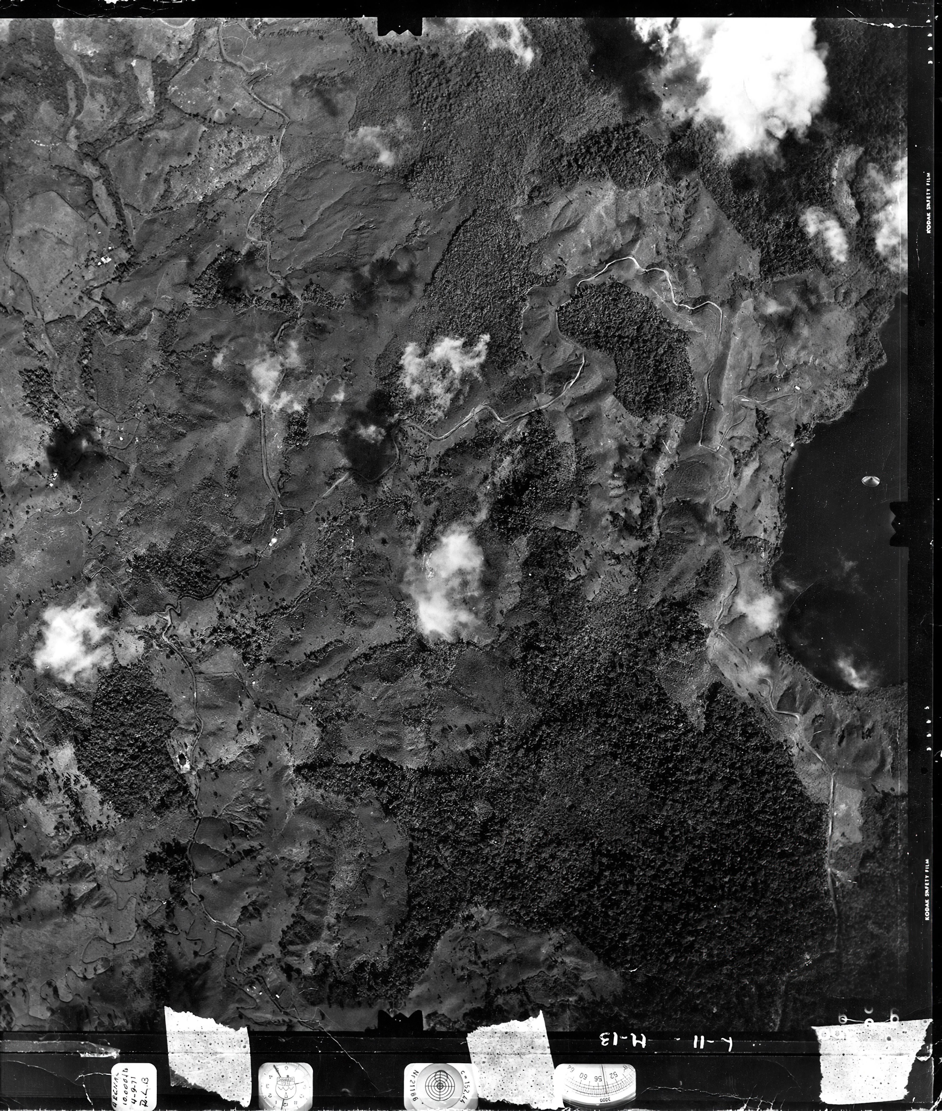
https://www.metabunk.org/f/Lake Cote LARGE Tape Scan From Reddit.jpg
Source:
Reddit H-M-1-1
Curiously, most published versions of the photo are of a lower contrast and lower resolution scan that the one above, making the feature (I hesitate to call it an object) seem smoother. The image I posted was shared on Reddit a month ago, and
seems to be a high resolution scan of a now slightly degraded negative (with added dirt and some tape around the edges). I can't find it in that resolution anywhere else. Here's a comparison of the old and new photos showing the amount of additional genuine [looking] detail. [
UPDATE: It's possible this might an AI upscaled version]
View attachment 44212
The new photo makes it look far less conical, with the apparent structure around the sides seeming almost bulbous. The dark shape in the center seems to have more definition too.
View attachment 44213
The location is 10.577071°, -84.912665°, the attached Google Earth image can be used to visualize it in place.
View attachment 44215
Measuring its size on the ground gives about 210 feet by 130 feet. Of course, the closer it is to the camera, the smaller it would be.
View attachment 44217
Being 50 years old, lots of people have had a crack at it. Here's some relevant excerpts:
Photo Analysis of an Aerial Disc Over Costa Rica
RICHARD F. HAINES & JACQUES F. VALLEE
Journal of Scientific Exploration, Vol. 3, No. 2, pp. 1 13-1 3 1, 1989
On the basis of these observations and on the authors' discussion of the inconsistent shadow patterns, it is my opinion that the oval image is more likely to be an artifact such as a pressure mark than a photographic image of a physical object.
...
Obviously this part of the discussion is based largely on conjecture, since the original film was not available for inspection. The particle hypothesis could, in principle, be tested by examining the original negative under strong, glancing incidence illumination. If the image is a pressure mark, it may be possible to find marks or scratches on the emulsion or local deformations in the film base.
On the morning of September 4, 1971, a plane from the Costa Rican Geographic Institute was taking photographs to map the area of the Arenal region. The four crew members did not remember seeing anything unusual, but then the camera was set to automatically photograph every 20 seconds or so. It was a special RMK 15/23 camera with ASA 80 bw film, with an 8x8 negative imprinted on Kodak air safety film, type 3665.
One shot was taken at an altitude of 10,000 feet, frame 300, showing the mountains around Lake Cote in the province of Guanacaste, 25 miles south of Nicaragua. A disc-shaped object clearly appeared in the lower half of the lake. The photo is to be considered unique and of great scientific value. Doctors Richard Haines and Jacques Vallée listed a number of reasons in their first study of the Lake Cote case, published in the Journal of Scientific Exploration in 1989:
While the report [of Haines and Vallee] did look into the possibility of some type of debris on the film or its film plane back-plate was discussed and disregarded, they never looked at the camera itself.
The camera system has a very unique optic system that looks very similar to the object in the photograph.
View attachment 44221
Because there were no eyewitness reports from the ground or the members of the mapping team there is not much of a chance of this being an object of approximately 683 feet in size or even something that was an actual object of any size flying in the air beneath the plane.
The problem that report had with the object not creating a shadow is easily explainable if the image was created by the optics of the camera and not a physical object below the plane.
The object in the image appears to have been created by reflections of ambient light inside the optics of the camera system caused by a unique combination of the type of camera system, angle of the plane to the light, position of the sun and possibly the angle of the light coming from the surface of the water located beneath the plane.
(And a rather speculative one)
Allow me to explain in the center of the disc there appears to be 2 black object on further examination and image processing it soon become obvious that the black object is in fact a large boat that for some unknown reason has suddenly slammed into reverse causing the wake around the boat just as the recon plane took the photograph the bright parts of the "UFO" are waves caused by the sudden reversal of the boat the reason they are bright is because they are reflecting sunlight.
The idea that it is 683 feet in size (about 208 meters) is possibly a units conversion error that has propagated for decades to all subsequent researchers because nobody bothered to check. It's about 210 feet, not 210 meters.
A recent discussion thread that links to the Reddit image can be found here:
https://archive.is/1sb7B, with the Reddit poster H-M-1-1, saying it was "Verified by Jacques Valle" - although it's not clear if they are referring to this new image, or Vallee's 1989 study of the image.
A key issue is the lighting. The sun in the image is coming from the lower right (about due west), and yet there's no real way light from that direction makes any sense for a physical object
View attachment 44218
And of course, there's no shadow. If it's a physical object that limits the possibilites.
Note that people raise various magical hypotheses to explain these problems, like the "UFO" being made of a light pumping metamaterial that moves light around in unexpected ways. I think we can much such explanations to the bottom of the list as they are highly speculative, and require some new physics.
I think the most likely explanation (but by no means certain) is that one suggested by the Rocky Mountain Paranormal Research Society, back in 2013:
The object in the image appears to have been created by reflections of ambient light inside the optics of the camera system caused by a unique combination of the type of camera system, angle of the plane to the light, position of the sun and possibly the angle of the light coming from the surface of the water located beneath the plane.
In 2014 this was expanded upon a little, suggesting a chip in the glass that only showed up when the sun caught it.
But I don't want to end without contributing my grain of sand to the case. The first time I saw the photograph it seemed to me that it could be something that was on the camera glass. It has all the appearance of a chip produced by a stone during a take off or landing. Surely it has ever happened to you on the windshield of the car. I went to look for the different brands that can appear on car windows and I found this:
View attachment 44219
The resemblance to the "Partial bullseye" impact is striking. Even the little circle in the center. But then why does it appear only in one photograph and not in the rest? The answer lies in Haines' analysis. The elevation of the sun at that time was 16º, and the camera was not perpendicular to the ground when it fired, possibly due to a spin of the plane. Sunlight was able to hit the chip sideways, producing reflections.
Given this newer image as only just (mysteriously) surfaced, perhaps some other ideas might spring to mind? If it is a camera artifact, the ideal solution would be to find something similar. I'm not entirely convinced that "The camera system has a very unique optic system that looks very similar to the object in the photograph." Perhaps some more detailed image of the camera internals (RMK A 15/23) can be found.
