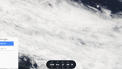
A user on reddit came up with a satellite picture taken on Nov 9 over the nimitz strike group training area.
It shows some pixelated lines above the clouds, that arguably look like compression artifacts.
However, I zoomed out and tried to find other lines like these but couldnt.
So I figured maybe, if these are real objects then they should reappear somewhere when I change the hours or even days.
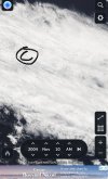
I then went to the next day and followed the wind direction and found them again in the south pacific ocean, supposedly moving with the wind.
If these are compression artifacts, then it might just be a funny coincidence with the wind direction and that i couldnt see them over / within / under other clouds, land or sea.
What is this? Could this have caused the radar tracks Kevin Day (the radar operator in the Nimitz incident) witnessed on his radar?
Photographs are from: https://zoom.earth/#view=-47.8,-148.7,3.9z/date=2004-11-10,am/layers=daily
- A) zoomed in on Nov 9
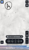
- B) zoomed out on Nov 9
- C) zoomed in on Nov 10
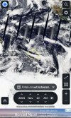
- D) zoomed out on Nov 10 (I marked the "lines" yellow)
PS: Open the pictures to see what I mean
It shows some pixelated lines above the clouds, that arguably look like compression artifacts.
However, I zoomed out and tried to find other lines like these but couldnt.
So I figured maybe, if these are real objects then they should reappear somewhere when I change the hours or even days.
I then went to the next day and followed the wind direction and found them again in the south pacific ocean, supposedly moving with the wind.
If these are compression artifacts, then it might just be a funny coincidence with the wind direction and that i couldnt see them over / within / under other clouds, land or sea.
What is this? Could this have caused the radar tracks Kevin Day (the radar operator in the Nimitz incident) witnessed on his radar?
Photographs are from: https://zoom.earth/#view=-47.8,-148.7,3.9z/date=2004-11-10,am/layers=daily
- A) zoomed in on Nov 9
- B) zoomed out on Nov 9
- C) zoomed in on Nov 10
- D) zoomed out on Nov 10 (I marked the "lines" yellow)
PS: Open the pictures to see what I mean
Attachments
Last edited:
") does that make sense? anyway i tracked it 3 days until i realized "zoom earth keeps changing the dates ...TLDR, i think its a dirty lens.
does that make sense? anyway i tracked it 3 days until i realized "zoom earth keeps changing the dates ...TLDR, i think its a dirty lens.