Claim The seabed around Kaikoura, New Zealand has risen by up to 1.8 m earthquake

derwoodii

Senior Member.
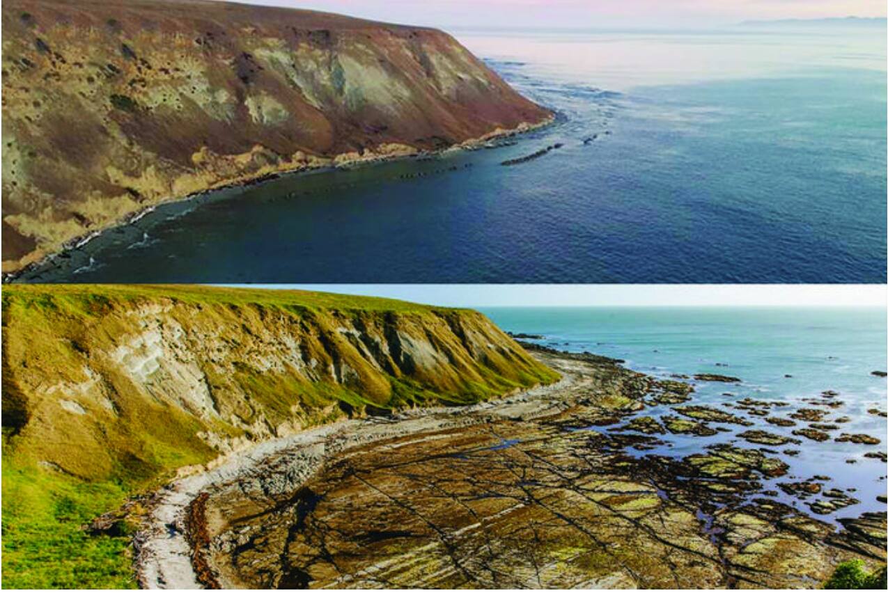
various sources and some credible claim the Kaikoura area sea bed had risen 1.8m

http://www.smh.com.au/environment/n...eds-by-more-than-a-metre-20161116-gsr41v.html

Dr Joshu Mountjoy, a marine geologist at the National Institute of Water and Atmospheric Research (NIWA), said the seabed lift was a first for modern New Zealand scientists.
Content from External Source
Can this be true? as i tend to see news pictures reveal more so the ocean tide, not earth rise


1479421757632.jpg


http://www.smh.com.au/environment/h...assive-new-zealand-quake-20161117-gss131.html
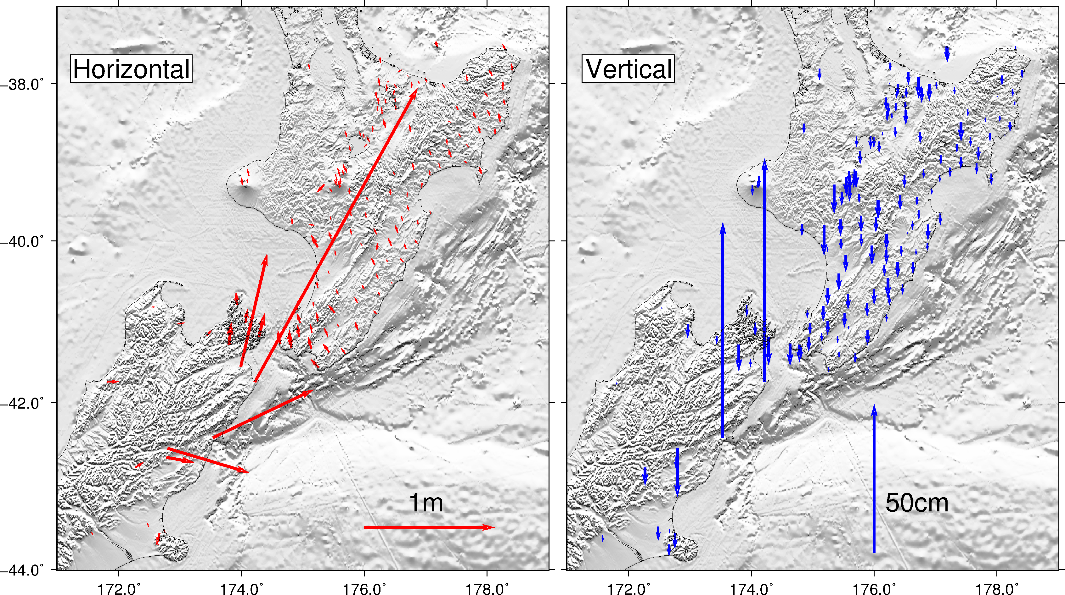
Scientists know a tide gauge at Kaikoura rose 90 centimetres during Monday's magnitude 7.8 earthquake, but that's one of the few pieces of detailed data so far about how much the level of the coastline has risen.
Data from the stations also show Cape Campbell moved horizontally north-east by two to three metres.
1-17112016.jpg

this vid is compelling as cray fish out of water is unnatural


Source: https://www.youtube.com/watch?v=ftdhSNuoeWw


Published on Nov 17, 2016
A fault rupture caused by the November 13 earthquakes has risen seabed near Kaikoura by more than a metre, exposing rocks and leaving some crayfish stranded on land. Clayton Lindstrom went to Waipapa Bay, about 20 miles from Kaikoura, to check on his brother?s boat and captured footage of the unusual scene. The video shows a section of the east coast, which would normally be submerged, above the sea along with many crayfish that would normally be under water. Stuff.co.nz said the rare event presented a unique opportunity for geologists and scientists
Content from External Source

All while possible and given evidence probable i struggle to grasp how the claimed sea bed lift did not cause tsunami wave..
 
I can well believe it is true in places. There are some aerial photos on this link showing a massive uplift creating a distinct scarp line. https://www.facebook.com/NelsonMarlboroughRescueHelicopter/posts/1191431484255466

For example, here's the coast road with what looks like an uplift of a couple of metres or more.

IMG_8420.JPG

And a view showing the new scarp crossing the beach, with newly exposed rocks and sea bed:

IMG_8421.JPG

In the comments on the latter photo the rescue helicopter people say it could be as much as a 5 metre uplift in that area! Obviously that's just an estimate from the air.
 
thanks TB that road picture tells the story clearly amazin fault fracture & i been up the road and rail line recently and we looked to stay in this Kaikoura motel till i took a looked at bulging rock face above the rooms,, said to dear wife ah ah nope not there..

325584525_475c03d1da.jpg

I guess if the earth lift occurred in shallow coast edge waters in fault sections not large lengths the energy & creation of tsunami wave maybe diminished.
 
I guess if the earth lift occurred in shallow coast edge waters in fault sections not large lengths the energy & creation of tsunami wave maybe diminished.

More close up footage from geologist Kelvin Berryman at GNS Science is available here:


He was auditing the damage in Waipapa Bay in which he said the noise from water running off the uplifted areas was "horrendous" according to locals.
 
im hoping this video is actually connected not taken from else and named as NZ quake wave tho i cant be sure as does not say location or by who and the published date is very close to actual quake date time


Source: https://www.youtube.com/watch?v=V2G8BCRUPnU


Published on Nov 13, 2016
A tsunami has hit New Zealand after a powerful earthquake struck the country's South Island, with the country's prime minister confirming two deaths.
Thousands of people on the country's east coast fled after a warning to move to higher ground.
The quake, which measured 7.8 in magnitude, led to waves up to two metres high, including in the Kaikoura area.
 
Hard to say where it is from...it looks a bit like Porirua on the west coast of the lower North Island - there's nowhere else in New Zealand that was near the quake zone that has a big inlet/bay built around like that....but the tsunami would have had to travel through Cook Straight between the 2 islands, which would have dissipated it a lot, and there's no reports of tsunami's in any of the areas in the straight itself.

Here's an early tsunami threat warning map - Porirua is about where the words "Kapiti Coast" appears bottom of the north island - in fact essentially no tsunami struck anywhere "green".


So I'm picking it's not from this NZ quake.
 
yes if the quake occurred two minutes after midnight on 14 November 2016 then its hard to see any wave front taking some 6 hours to reach any north or south island inlet in the day lite when we have other video showing the surge effect at nite
 
so hard to know, is that just tides or is that quake heave? it was the 1st OP news picture that peeked my interest as looked to be only tidal water marks but i have been shown credible evidence that much earth heave happened its just been muddled in poor news pictorial reports or by those who like to claim them self's as insightful.... oh dear just realized expanding earth chap Neal Adams will jump on saying proof the planet is getting bigger..
 
so hard to know, is that just tides or is that quake heave? it was the 1st OP news picture that peeked my interest as looked to be only tidal water marks but i have been shown credible evidence that much earth heave happened its just been muddled in poor news pictorial reports or by those who like to claim them self's as insightful.... oh dear just realized expanding earth chap Neal Adams will jump on saying proof the planet is getting bigger..
The tidal range on the west coast of NZ is not very big, as far as I can see. No more than about two metres variation: http://www.metservice.com/marine-surf/tides/kaikoura
 
What happened to that island on the horizon?

Probably just slightly off to right of picture - they aren't perfectly hte same frame. Plus I suspect that is the North Island - so there's usually a lot of haze in the way and any bits that are in picture are probably hidden.
 
I think this is quake heave, Paua has been exposed and there was an effort to try and save them after the earthquake as they are all out of the water now

http://i.stuff.co.nz/national/nz-ea...ether-to-save-stranded-shellfish-and-sea-life

I live in NZ and all the pictures I have seen before and after on that coast road are incredible, but I haven't actually seen it with my own eyes.


welcome mish & yes agree at 1st i was bit unsure but MB contributors here have helped ( as always they do)

here a handy vid graphic..


Source: https://www.youtube.com/watch?v=2pqulG_s04s&feature=youtu.be
 
im hoping this video is actually connected not taken from else and named as NZ quake wave tho i cant be sure as does not say location or by who and the published date is very close to actual quake date time


Source: https://www.youtube.com/watch?v=V2G8BCRUPnU


Published on Nov 13, 2016
A tsunami has hit New Zealand after a powerful earthquake struck the country's South Island, with the country's prime minister confirming two deaths.
Thousands of people on the country's east coast fled after a warning to move to higher ground.
The quake, which measured 7.8 in magnitude, led to waves up to two metres high, including in the Kaikoura area.


Dazza did a vid on the false claim of that vid being the from the recent quake. I think it's this one:


Source: https://www.youtube.com/watch?v=wWQma1HhJY0&t=3s
 
Sorry for the bump, but as someone who lived in Napier it reminds me of the land where they built the airport which before 1931 was underwater , also a 7.8 magnitude shake
The local landscape changed dramatically, with the coastal areas around Napier being lifted by around two metres.[7] The most noticeable land change was the uplifting of some 40 km2 of sea-bed to become dry land. This included Ahuriri Lagoon, which was lifted more than 2.7 metres[7] and resulted in draining 2230 hectares of the lagoon. Today, this area is the location of Hawkes Bay Airport, housing and industrial developments and farmland.
https://en.wikipedia.org/wiki/1931_Hawke's_Bay_earthquake
 
As it happens, I was in Kaikura in January 2020, and walked out on some of the land that was elevated from it's former condition as sea bottom. It has now become a favorite haunt for fur seals, and tourists who want to see them. (There's a nursery colony a bit further south, adult seals with no pups seem to prefer this quieter spot).P1160549.JPG

The "rock" was about halfway between rock and clay/mud, with scattered pebbles a few inches across, and this particular chunk of new-ish land that I walked on was perhaps a thousand feet long extending from the old shore, by roughly 250-300 feet wide, the long bit extending off to my right in this image.
P1160489.JPG

There were striking bits of geology evident here and there, folding and compression speaking to the power that thrust this land up from the water:
P1160502.JPG
The road and railroad just south of town was undergoing a lot of construction which I was told is still a continuation of getting things back to normal from the quake.
 
Back
Top