Latest activity
What's new
Staff online
-
 flarkeySenior Member.
-
 I'm not ready to take a position on whether or not it is a parachute, but I don't think this point is compelling. In turbulence or in other conditions where the parachute and flare-or-whatever are moving about relative to one another(the chute...
 -
brasco replied to the thread Welcome Thread - New Members Post Here.Hi all, I'm a 3D generalist from the UK, so I've enjoyed reading debunks on here over the years as it crosses over well with replicating reality (cameras, optics, material science etc). I've visited occasionally for quite a few years but with...
-
John J. reacted to jarlrmai's post in the thread Ukrainian drone footage of 6 pointed star with
 Like.
Typhoon displayed on the overlay is the name of Ukraine's specialised drone unit https://en.wikipedia.org/wiki/Typhoon_Unit_(Ukraine) This company provides balloons/aerostats for a variety of purposes in Ukraine...
Like.
Typhoon displayed on the overlay is the name of Ukraine's specialised drone unit https://en.wikipedia.org/wiki/Typhoon_Unit_(Ukraine) This company provides balloons/aerostats for a variety of purposes in Ukraine... -
John J. reacted to Mick West's post in the thread Ukrainian drone footage of 6 pointed star with Like.
More on "Flash" (from two years ago), https://www.technologyreview.com/2024/09/12/1103833/ukraine-russia-drone-war-flash-radio-serhii-beskrestnov-social-media/ This anecdote is emblematic of Flash's frustration with a military complex that may...
-
Yes, read the thread. You're welcome to challenge the rebuttals in it.
-
No evidence of any of that ever happening. Just the girls. There is no evidence that any autopsy ever took place. The better theory is that whatever ex-soldier it is you're talking about, he is making stuff up. Once you realize the fact that his...
-
John J. reacted to Apaiss's post in the thread War.gov/UFO - Department of War Releases UAP Files - 2026 Release 1 with Like.
A few years ago I made a video about various "anomalies" in the photos from the Apollo 7 and Gemini 11 missions, in response to several videos of "UFOs" in those mission. I researched the history of these photos, from storage to scanning. If I'm...
-
brasco replied to the thread Ukrainian drone footage of 6 pointed star.Long shot, but could this be a trailing fibre optic cable on the drone being overloaded somehow? Here's an overloaded fibre with a laser in Ukraine: Source: https://www.youtube.com/watch?v=m2-p2srIRLI Maybe some damage along the line, and it...
-
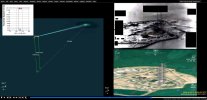
 Mick West replied to the thread PR039 - Undisclosed Location 2020 [Farsi Island].A rough fit for the object suggests it's a small windblown thing. https://www.metabunk.org/sitrec/?custom=1/PR39%20Farsi%20Island/20260512_101130.js
 -
-
Mick West reacted to flarkey's post in the thread PR039 - Undisclosed Location 2020 [Farsi Island] with
 Winner.
This is not a great video... https://www.dvidshub.net/video/1006089/dow-uap-pr39-unresolved-uap-report-middle-east-2020 ... however I think it is Farsi Island: https://en.wikipedia.org/wiki/Farsi_Island Google Maps 27°59'35.0"N 50°10'21.0"E
Winner.
This is not a great video... https://www.dvidshub.net/video/1006089/dow-uap-pr39-unresolved-uap-report-middle-east-2020 ... however I think it is Farsi Island: https://en.wikipedia.org/wiki/Farsi_Island Google Maps 27°59'35.0"N 50°10'21.0"E -
RRobertBillyBob reacted to flarkey's post in the thread PR039 - Undisclosed Location 2020 [Farsi Island] with Winner.
This is not a great video... https://www.dvidshub.net/video/1006089/dow-uap-pr39-unresolved-uap-report-middle-east-2020 ... however I think it is Farsi Island: https://en.wikipedia.org/wiki/Farsi_Island Google Maps 27°59'35.0"N 50°10'21.0"E
-
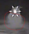
 What is your evidence that these two images were captured from the same platform? Different platforms won't match, as artefacts like diffraction spikes and lens flares are intimately related to the geometry of the optics.
 -
The shooting distances of the two videos are completely different. In the first video, the parachute is already so far away that it is almost invisible, appearing even smaller on the infrared imaging than the glare of the flare suspended below...
-
RRobertBillyBob reacted to jarlrmai's post in the thread Ukrainian drone footage of 6 pointed star with Like.
Typhoon displayed on the overlay is the name of Ukraine's specialised drone unit https://en.wikipedia.org/wiki/Typhoon_Unit_(Ukraine) This company provides balloons/aerostats for a variety of purposes in Ukraine...
-
 jarlrmai replied to the thread Ukrainian drone footage of 6 pointed star.Typhoon displayed on the overlay is the name of Ukraine's specialised drone unit https://en.wikipedia.org/wiki/Typhoon_Unit_(Ukraine) This company provides balloons/aerostats for a variety of purposes in Ukraine...
 -