Hunga Tonga Volcano Eruption and Tsunamis

Mick West

Administrator
Staff member
Very impressive images from Himawari-8 and GOES-17 satellites


Source: https://twitter.com/weatherdak/status/1482237555764383745


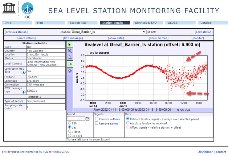
Source: https://twitter.com/NWSHonolulu/status/1482259099458932737


The Tsunamis have been significan in Tonga (several feet, flooding), but fairly minor in the continental US so far.

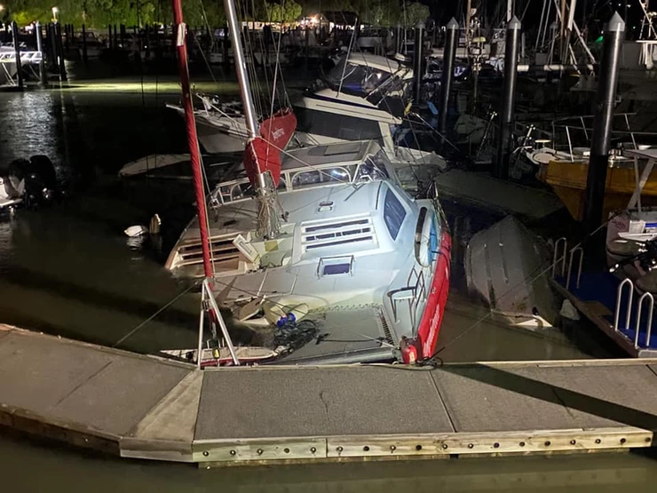
Source: https://twitter.com/NWSBayArea/status/1482381281258205189


A bit bigger in Hawaii, but still just and extra foot or so on waves. More significant because it's happening at high tide.

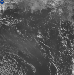
Source: https://twitter.com/NWSBayArea/status/1482384322866790400
 
Last edited:
Yeah impressive, largest eruption since Pinatubo I believe. That initial ash burst looked to be about the size of Spain

A 1.3 meter wave even reached NZ and sank a few boats, Though if you look at the following graph it looks like crest and trough of the wave were nearly 3 meters


Scott Manley has an interesting 8-minute video with info on this volcanic eruption:


Source: https://youtu.be/zoMRwyNhqJ4

At 3:50, he features an animation of lightning strikes that were recorded at the location of the volcano - as if the big ongoing explosion alone weren't bad enough... o_O
 
I'd love to see a scale of miles superimposed on the satellite images, along with a time stamp. Does anyone have that info?
 
I'm not seeing any of the usual mob claiming they had predicted this eruption by watching sunspots, horoscopes or was influenced by 5g Gates or organisation like Spectre vs James bond.
 
I'd love to see a scale of miles superimposed on the satellite images, along with a time stamp. Does anyone have that info?
From wikipedia

Satellite animation of the initial ash plume and sonic boom on 15 January over a period of 1 hour and 40 minutes

Im not sure how accurate the following is, but if you look at google maps and measure the distance between the islands it looks quite close
(It's france btw ;))

 
I'd love to see a scale of miles superimposed on the satellite images, along with a time stamp. Does anyone have that info?
i don't see exactly what you are looking for, so i don't know the expansion speed for different time periods.


Article:
Plumes from the explosion reached more than 12 miles above sea level, according to the Tonga Geological Services. At its widest, the cloud caused by the ash and steam reached about 150 miles across, making it easily seen from satellites.


1642431325145.png

https://en.wikipedia.org/wiki/2022_Hunga_Tonga_eruption_and_tsunami

------------------------------------------------------------------------------------
a longer period of time:
2022-01_20220113_HungaTonga1.gif
Article:
According to local officials, the eruption had a radius of 260 km (161.5 miles), and sent ash, steam, and gas 20 kilometers (12.4 miles) into the air.


-----------------------------------------
G17_sector_tsp_GEOCOLOR_24fr_20220115-0412_slowed_stopped.gif
https://en.wikipedia.org/wiki/2022_...EOCOLOR_24fr_20220115-0412_slowed_stopped.gif
 
I'm not seeing any of the usual mob claiming they had predicted this eruption by watching sunspots, horoscopes or was influenced by 5g Gates or organisation like Spectre vs James bond.
Hold on there mate, it wasn't 5g or sunspots, it was a massive bomb! So Gates could still be involved.

This "Southwest Prepper Group" has over 11k subscribers and is reposting a TikTok of some kind "showing" something hitting the water right before the eruption. Southwest Prepper isn't exactly saying this is true, just asking for thoughts, but when someone pointed out that this volcano has a history of doing this, he(?) wasn't so sure:

1642627326357.png

This had 1,135 views as of 1/7. To be fair, there are only 12 comments and most are, like above, "it's just a volcano", but not all:

1642626946290.png
1642627003614.png

A few screen grabs below. Assuming this is some actual footage of the eruption, it's time lapsed, so it appears that the "object" that flies in and "splashes" before the eruption seems to be pareidolia about some changing clouds, I'm thinking. Some of the other clouds also change between each picture.

The original TikTok creator is who I assume is talking. He claims that in the first two shots below, that the "white object" is traveling in the air. In the third shot it "splashes" into the water and continues on underwater in shot four, then the eruption begins.

1642625759938.png 1642625837720.png1642625937730.png1642626512301.png1642626018093.png1642626088806.png


Source: https://www.youtube.com/watch?v=jtC19h5JM5A

Amazing how the object so accurately impacted at the location of a known volcano. What are the odds of that??
 
One might ask, what have the possessors of this mighty technology got against the Tongans? Seems an odd choice of targets.
 
Last edited:
I didn’t look closely at the link so is the idea that it was an object *targeted* at an active volcano?
Your trying to be logical and getting caught up in details. Obviously something crashed into the ocean and then there was a big explosion is about as far as they got.

What they really missed, is, this destructive object out over the Pacific kind of looks like a TicTac, right?
1642694305041.png
 
Your trying to be logical and getting caught up in details. Obviously something crashed into the ocean and then there was a big explosion is about as far as they got.

What they really missed, is, this destructive object out over the Pacific kind of looks like a TicTac, right?
1642694305041.png
In that image I see multiple things that look exactly like that just below. So either a cut and paste job or at least four objects were coming and only one wasn’t a dud.
 
One might ask, what have the possessors of this mighty technology got against the Tongans? Seems an odd choice of targets.
See, that's the thing - this of course was just a trial run; the intended target for the next, real one is the U.K. - more adverse events to distract from Boris Johnson's bumbling...
 
good pictures with distance scale

https://www.bbc.com/news/world-australia-60027360

A massive volcanic eruption in Tonga, on Saturday, triggered a tsunami that spread across the Pacific in a matter of hours.
Content from External Source

Waves hit Australia, New Zealand and Japan as well as the west coasts of North and South America, and an atmospheric shockwave was detected around the world.
Thousands of people in Tonga are thought to be in need of outside help, with buildings destroyed and communications disrupted.
Here's what we know about how and why it spread so widely and violently.
Content from External Source
_122936958_eruption_plume.jpg_122854952_tonga_volcano_eruption_v5_2x640-nc.png
 
THAT'S the one I'd love to see on a globe vs a flat disc, if any of you are animation savy and are snowed in and in need if a project today.
It’d seem to depend on which flat earth model is used. Some flat earthers think there is constant air from the ground to the dome (vacuum requires a vessel arguments), so the pressure wave would bounce off of the dome in addition to the Antarctic ice wall. Height to the dome is unknown or at least has no definitive answer that I’ve seen.
 
It’d seem to depend on which flat earth model is used. Some flat earthers think there is constant air from the ground to the dome (vacuum requires a vessel arguments), so the pressure wave would bounce off of the dome in addition to the Antarctic ice wall. Height to the dome is unknown or at least has no definitive answer that I’ve seen.
hmm, first approximation would be a flat wave bouncing off the "ice wall", that would already contradict a lot.

The dome ought to be hemispherical, the problem is that barometric altimeters work in every airplane, which means air pressure changes with altitude, and so does the speed of sound in air. We also don't know how much of the wave energy is absorbed by the dome; if there isn't a lot of absorption, the height of the dome should have been measured a long time ago.

The container is only needed when you take something out of its rightful place in the buoyancy column, btw.
Yes. Flat earthers can’t explain the drop in pressure with altitude, especially those who don’t believe that gravity exists. You can’t even address questions like this because there is no coherent model for a flat earth. Their beliefs violate fundamental understanding of physics and violate even simple mathematics, both of which can trivially show the flaws in their model with simple observations of the real world. So exploring real world questions in their model will immediately cause problems, like a race horse tripping out of the gate.
 
It’d seem to depend on which flat earth model is used. Some flat earthers think there is constant air from the ground to the dome (vacuum requires a vessel arguments), so the pressure wave would bounce off of the dome in addition to the Antarctic ice wall. Height to the dome is unknown or at least has no definitive answer that I’ve seen.
Sorry, I was unclear. I'd love to see an animation of the observed pressure wave moving across a globe, and the weirdness that would happen with the observed wave as projected onto the usual flat map. Not how it would have behaved if their model (if they had one) was true, just how the moving wave would have to look on the projection they use for a flat world map.
 
Sorry, I was unclear. I'd love to see an animation of the observed pressure wave moving across a globe, and the weirdness that would happen with the observed wave as projected onto the usual flat map. Not how it would have behaved if their model (if they had one) was true, just how the moving wave would have to look on the projection they use for a flat world map.
So, basically the track of the pressure wave on a polar azimuthal equidistant projection map?
 
The only way that flat earth works with the intermediate station readings is if the volcano and every volcano that explodes is at the centre of the disc, and there's no way it works with the readings at the antipode unless that station is located simultaneously at all points along the rim, flat earth is a nonsense theory that fails at even the most cursory challenge.
 
No, what I am looking for would not have reflections at the edge, since there were none. It would contrast the expanding and the contracting circle on a globe with the weird oval-for-no-reason propagation that the data would show on a flat map, and whatever weirdness would have to happen as the wave passed the south pole. (I have a hard time visualizing how that would look.) The point being that the pressure wave obseved sweeping around the world looks fine on a globe, but as observed makes no sense in a flat earth map.
 
No, what I am looking for would not have reflections at the edge, since there were none. It would contrast the expanding and the contracting circle on a globe with the weird oval-for-no-reason propagation that the data would show on a flat map, and whatever weirdness would have to happen as the wave passed the south pole. (I have a hard time visualizing how that would look.) The point being that the pressure wave obseved sweeping around the world looks fine on a globe, but as observed makes no sense in a flat earth map.
What it would likely look like is an expanding circle at first that would warp out to a huge oval on the south side that would wrap all the way around the flat earth and then close back in on itself near the antipode. On the globe, the South Pole is a point but on the flat earth it's a circle, so at some point the pressure wave would blow up to cover the entire perimeter of the flat earth.
 
Back
Top