Latest activity
-
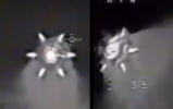
 Starflint replied to the thread Ukrainian drone footage of 6 pointed star.The fact that the "UAP" axis coincides with the lens axis, as discussed previously, also seems to be a reason why the "UAP" appears to be attached to the lens. In that case, perhaps the actual size of this object is very small; a bullet hole or a...
 -
Starflint replied to the thread Ukrainian drone footage of 6 pointed star.The fact that the "UAP" axis coincides with the lens axis, as discussed previously, also seems to be a reason why the "UAP" appears to be attached to the lens. In that case, perhaps the actual size of this object is very small; a bullet hole or a...
-
Starflint reacted to flarkey's post in the thread Ukrainian drone footage of 6 pointed star with
 Like.
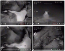
Just another observation with this, we can see that the size of the lake in the video gets bigger between the 0m11s and 1m20s time codes of the video, and therefore we can deduce that the drone is loosing altitude. However the position of the...
Like.
Just another observation with this, we can see that the size of the lake in the video gets bigger between the 0m11s and 1m20s time codes of the video, and therefore we can deduce that the drone is loosing altitude. However the position of the... -
 Fritzkquzerk replied to the thread Ukrainian drone footage of 6 pointed star.Yeah, the Change in orientation is weird if it’s an artifact. If it’s attached to the drone, what could it be?
 -
Fritzkquzerk reacted to flarkey's post in the thread Ukrainian drone footage of 6 pointed star with Like.
Just another observation with this, we can see that the size of the lake in the video gets bigger between the 0m11s and 1m20s time codes of the video, and therefore we can deduce that the drone is loosing altitude. However the position of the...
-
Fritzkquzerk reacted to teloiv's post in the thread Ukrainian drone footage of 6 pointed star with Like.
This might be the location, 48°17'40.0"N 37°23'03.0"E looking due south. There's not a lot of pixels but to me the start and pan down sorta looks like the fields and town. The general water shape seems good. The darker lines leading off the body...
-
Fritzkquzerk reacted to flarkey's post in the thread Ukrainian drone footage of 6 pointed star with Like.
Wow, great find. That is the exact spot. It shows that my suggestion in post #15 that we might be seeing the tail-booms of a drone is complete rubbish. The lines are just fields and hedges.
-
 flarkey replied to the thread Ukrainian drone footage of 6 pointed star.Just another observation with this, we can see that the size of the lake in the video gets bigger between the 0m11s and 1m20s time codes of the video, and therefore we can deduce that the drone is loosing altitude. However the position of the...
 -
-
Fritzkquzerk replied to the thread Ukrainian drone footage of 6 pointed star.I thought about it, what could it be? I was thinking of maybe a source heat (since the weird “steam” / “exhaust” effect behind the object. So we got the artifact from heat (glare?) of something like a structure on the ground. The second frame I...
-
 Ravi replied to the thread War.gov/UFO - Department of War Releases UAP Files - 2026 Release 1.The military grade IR cameras are for sure capable of HD or higher resolution. Not all of them (as older types are in use too), but modern equipment has high resolution. It is just down graded when made available to the public.
 -
Ravi reacted to Bruce M's post in the thread War.gov/UFO - Department of War Releases UAP Files - 2026 Release 1 with
 Agree.
Thats not true. Even in 2018, you could get 720p HD IR cameras on the mid sized MX15. https://www.militarysystems-tech.com/sites/militarysystems/files/supplier_docs/PDS-MX-15-March-2018.pdf Sensor #1b - HD Thermal Imager: Type: Resolution...
Agree.
Thats not true. Even in 2018, you could get 720p HD IR cameras on the mid sized MX15. https://www.militarysystems-tech.com/sites/militarysystems/files/supplier_docs/PDS-MX-15-March-2018.pdf Sensor #1b - HD Thermal Imager: Type: Resolution... -
Wow, great find. That is the exact spot. It shows that my suggestion in post #15 that we might be seeing the tail-booms of a drone is complete rubbish. The lines are just fields and hedges.
-
This might be the location, 48°17'40.0"N 37°23'03.0"E looking due south. There's not a lot of pixels but to me the start and pan down sorta looks like the fields and town. The general water shape seems good. The darker lines leading off the body...
-
AAndreas reacted to teloiv's post in the thread Ukrainian drone footage of 6 pointed star with
 Winner.
This might be the location, 48°17'40.0"N 37°23'03.0"E looking due south. There's not a lot of pixels but to me the start and pan down sorta looks like the fields and town. The general water shape seems good. The darker lines leading off the body...
Winner.
This might be the location, 48°17'40.0"N 37°23'03.0"E looking due south. There's not a lot of pixels but to me the start and pan down sorta looks like the fields and town. The general water shape seems good. The darker lines leading off the body... -
Starflint reacted to teloiv's post in the thread Ukrainian drone footage of 6 pointed star with Winner.
This might be the location, 48°17'40.0"N 37°23'03.0"E looking due south. There's not a lot of pixels but to me the start and pan down sorta looks like the fields and town. The general water shape seems good. The darker lines leading off the body...