Latest activity
-
 While we're being silly, I missed the cow altogether but I'm sure I've found the site of the "Lost Pomeranian" mine.
 -
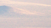
Roughly at 37.11573046856453, -115.83865333123748 Computers are realy good at suggesting a degree of accuracy that means very little. Decimal degrees to 6 decimal places means accurate to about one-tenth of a meter. The numbers it gave you...
-
According to Luigi, image 501 from Gabriel Zeifman was the one used as the source by Scott Mitchell This is it here: Source: drive.google.com/file/d/1FEMZxdz3A7fEAYM8QrFSea9dD6675FDR/view If you zoom in to the area in question: You could...
-
Pardon the AI..
-
Not sure about secret UFO hangers, but I definitely see a sacred cow... The supposed hangers are at the red arrow. Roughly 37.11573046856453, -115.83865333123748
-
 jackfrostvc replied to the thread S4: The Bob Lazar Story Evidence?.According to Luigi, image 501 from Gabriel Zeifman was the one used as the source by Scott Mitchell This is it here: Source: drive.google.com/file/d/1FEMZxdz3A7fEAYM8QrFSea9dD6675FDR/view If you zoom in to the area in question: You could...
 -
-
Minus0 reacted to NorCal Dave's post in the thread Rep. Luna Requests UAP Video, With a List of Names. with
 Like.
Maybe. But if we look at the big 3 from the whole NYT/AATIP/TTSA reveal, we get a mashup of names with limited context. GIMBAL, GO FAST and TICTAK are the names we know them by and may be the names used internally, but by who? As has been noted...
Like.
Maybe. But if we look at the big 3 from the whole NYT/AATIP/TTSA reveal, we get a mashup of names with limited context. GIMBAL, GO FAST and TICTAK are the names we know them by and may be the names used internally, but by who? As has been noted... -
Minus0 reacted to jarlrmai's post in the thread Rep. Luna Requests UAP Video, With a List of Names. with
 Funny.
Dear America. Please share as much MQ-9 camera footage as possible for our analysts. Thanks, your rivals
Funny.
Dear America. Please share as much MQ-9 camera footage as possible for our analysts. Thanks, your rivals -
 Pardon the AI..
 -
Mendel replied to the thread Rep. Luna Requests UAP Video, With a List of Names..Evidence is apparently not required, either. 1984 in a nutshell.
-
Minus0 replied to the thread Scientific Coalition for UAP Studies Announces 2025 Annual Conference.Source: https://youtu.be/CLMlUaEPuXM Not sure if this deserves its own thread. Lee describes a number of new cases he believes can’t be explained. From the description: I find it quite interesting how he focusses so much on the credibility...
-
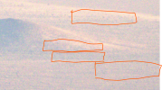
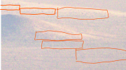
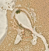
 Using Giddierone's location of 37.11573046856453, -115.83865333123748 in Google Maps, it looks like the linear-ish features are probably natural, just as they do in Giddierone's post #16, and in @Ann K's post #12 featuring the same hill. The...
 -
 Giddierone replied to the thread S4: The Bob Lazar Story Evidence?.I saw some people online speculating about this round looking thing nearby (top of the cows tongue) 37° 6'36.28"N 115°50'23.20"W The teardrop area above it seems to get filled by rainwater runoff every now and then. wider view (blue is the...
 -
-
I had something like a black and white dairy cow, with a slightly disconnected tongue (bottom right). Milking it I know...