Latest activity
What's new
Staff online
-
 Mick WestAdministrator
-
 Alien Chess Fiend reacted to Mick West's post in the thread Weaponized: Triangle Formation UAP in the Persian Gulf with
 Like.
Source: https://www.youtube.com/watch?v=8j2_xZG_CTA Investigative journalists Jeremy Corbell and George Knapp have obtained and are revealing for the first time military-filmed footage of multiple UAP (Unidentified Anomalous Phenomena)...
Like.
Source: https://www.youtube.com/watch?v=8j2_xZG_CTA Investigative journalists Jeremy Corbell and George Knapp have obtained and are revealing for the first time military-filmed footage of multiple UAP (Unidentified Anomalous Phenomena)... -
 Gary C reacted to Mick West's post in the thread Weaponized: Triangle Formation UAP in the Persian Gulf with
 Useful.
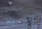
Since the system is not locked onto an aerial target, it shows the distance to the ground behind the middle of the screen. We can convert these numbers to altitude using Pythagoras. SLR is the hypotenuse, the slant range GDR is the base of the...
Useful.
Since the system is not locked onto an aerial target, it shows the distance to the ground behind the middle of the screen. We can convert these numbers to altitude using Pythagoras. SLR is the hypotenuse, the slant range GDR is the base of the... -
Gary C reacted to Mick West's post in the thread Weaponized: Triangle Formation UAP in the Persian Gulf with
 Funny.
Source: https://www.youtube.com/watch?v=8j2_xZG_CTA Investigative journalists Jeremy Corbell and George Knapp have obtained and are revealing for the first time military-filmed footage of multiple UAP (Unidentified Anomalous Phenomena)...
Funny.
Source: https://www.youtube.com/watch?v=8j2_xZG_CTA Investigative journalists Jeremy Corbell and George Knapp have obtained and are revealing for the first time military-filmed footage of multiple UAP (Unidentified Anomalous Phenomena)... -
 Apols if I overlooked this. Source: https://www.youtube.com/watch?v=DE3r_CgScms
 -
GM4AJK reacted to Mick West's post in the thread Weaponized: Triangle Formation UAP in the Persian Gulf with Useful.
Since the system is not locked onto an aerial target, it shows the distance to the ground behind the middle of the screen. We can convert these numbers to altitude using Pythagoras. SLR is the hypotenuse, the slant range GDR is the base of the...
-
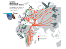
 Dave51c replied to the thread Weaponized: Triangle Formation UAP in the Persian Gulf.Having an interest in ecology and biodiversity I just learned that the region in question is a major migration route for birds. Source: https://www.arabnews.com/node/1495416/middle-east There are some physically big species like crane, stork...
 -
-
MonkeeSage reacted to Unlucky.pea1's post in the thread Welcome Thread - New Members Post Here with Like.
Hello everyone! Big conspiracy guy over here. Probably just crazy.
-
Dave51c reacted to JFDee's post in the thread Weaponized: Triangle Formation UAP in the Persian Gulf with
 Agree.
This is 50 km from the Iranian coast, well in the range of typical shorebirds. It may also be migrating birds; the wing flap frequency suggests a larger species, like spoonbills which are spending winters there - like numerous other species. I...
Agree.
This is 50 km from the Iranian coast, well in the range of typical shorebirds. It may also be migrating birds; the wing flap frequency suggests a larger species, like spoonbills which are spending winters there - like numerous other species. I... -
 flarkey reacted to Mick West's post in the thread Weaponized: Triangle Formation UAP in the Persian Gulf with Agree.
Since the system is not locked onto an aerial target, it shows the distance to the ground behind the middle of the screen. We can convert these numbers to altitude using Pythagoras. SLR is the hypotenuse, the slant range GDR is the base of the...
flarkey reacted to Mick West's post in the thread Weaponized: Triangle Formation UAP in the Persian Gulf with Agree.
Since the system is not locked onto an aerial target, it shows the distance to the ground behind the middle of the screen. We can convert these numbers to altitude using Pythagoras. SLR is the hypotenuse, the slant range GDR is the base of the... -
flarkey reacted to JFDee's post in the thread Weaponized: Triangle Formation UAP in the Persian Gulf with Agree.
This is 50 km from the Iranian coast, well in the range of typical shorebirds. It may also be migrating birds; the wing flap frequency suggests a larger species, like spoonbills which are spending winters there - like numerous other species. I...
-
 JFDee reacted to Mick West's post in the thread Weaponized: Triangle Formation UAP in the Persian Gulf with Like.
The drone (i.e. the camera platform drone). It is not locked onto the target, so it knows nothing about it. Purely visual. Correct, although that's not that relevant in calculating the altitude above the ocean. Any point would do.
JFDee reacted to Mick West's post in the thread Weaponized: Triangle Formation UAP in the Persian Gulf with Like.
The drone (i.e. the camera platform drone). It is not locked onto the target, so it knows nothing about it. Purely visual. Correct, although that's not that relevant in calculating the altitude above the ocean. Any point would do. -
Mick West replied to the thread Weaponized: Triangle Formation UAP in the Persian Gulf.It does get a lock at this point, but it's on what seems to be a wave (the objects continue off screen). The SLR and GDR don't change when it happens. The 14M is, I think, the size of the rectangle indicated by the corners. Which makes the...
-
-
Mick West replied to the thread Weaponized: Triangle Formation UAP in the Persian Gulf.The drone (i.e. the camera platform drone). It is not locked onto the target, so it knows nothing about it. Purely visual. Correct, although that's not that relevant in calculating the altitude above the ocean. Any point would do.
-
JFDee replied to the thread Weaponized: Triangle Formation UAP in the Persian Gulf.Is that the altitude of the drone or the targets? The coordinates and the elevation appears to be tied to the point behind the crosshair, right?
-
JFDee replied to the thread Weaponized: Triangle Formation UAP in the Persian Gulf.From the flapping, I'd say they are oriented in NE/SW direction, according to the camera bearing. Hard to say which direction they are going; if it's NE then they are right on course to the estuaries at the Iranian coast, like at Halieh Bay.