Latest activity
What's new
-
 Fritzkquzerk replied to the thread Looking for help interpreting a video content.God I love the Gran Voyager!
 -
 NorCal Dave replied to the thread Looking for help interpreting a video content.I'm leaning towards that as likely. However, I still can't figure out the odd arrangement. Your example is a common RV window, with a fixed panel on top and vented ones down low, but it's still all 1 piece: Our UFO attracting "van" seems to...
 -
-
No one is entertaining a conspiracy theory. The discussion here has been about trying to understand the commentary around the ballistics and why there's not universal agreement about the outcome.
-
 JMartJr reacted to flarkey's post in the thread Looking for help interpreting a video content with
 Like.
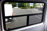
I think the window suggest a RV type vehicle. This is from the video: Something like this... (Source: https://rv-boondocking-adventure.com/rv-window-replacement)
Like.
I think the window suggest a RV type vehicle. This is from the video: Something like this... (Source: https://rv-boondocking-adventure.com/rv-window-replacement) -
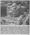
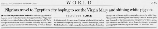
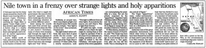
 Giddierone replied to the thread Our Lady of Assuit Need Debunking.There are several alleged mass sightings of an apparition of the Virgin Mary in Egypt (as well as other place in the world). For example 2 April 1968 over a Coptic Orthodox church of Zeitoun, (see https://skeptoid.com/episodes/766). Then a couple...
 -
-
 John J. reacted to flarkey's post in the thread Looking for help interpreting a video content with Like.
I think the window suggest a RV type vehicle. This is from the video: Something like this... (Source: https://rv-boondocking-adventure.com/rv-window-replacement)
John J. reacted to flarkey's post in the thread Looking for help interpreting a video content with Like.
I think the window suggest a RV type vehicle. This is from the video: Something like this... (Source: https://rv-boondocking-adventure.com/rv-window-replacement) -
 Gary C reacted to FatPhil's post in the thread Looking for help interpreting a video content with Like.
The post I was responding to said, about that situation, "which would negate reflection off of the window". I feel we are in violent agreement - that particular claim is bunk.
Gary C reacted to FatPhil's post in the thread Looking for help interpreting a video content with Like.
The post I was responding to said, about that situation, "which would negate reflection off of the window". I feel we are in violent agreement - that particular claim is bunk. -
"Damage" might be under-selling it, a bit.
-
The article is already two years old, so it doesn't seem to have led to anything. Perhaps the witness is no longer alive, which is a common problem when investigating old UFO cases. To me, it mostly feels like Wilson was just looking for...
-
Fritzkquzerk replied to the thread Our Lady of Assuit Need Debunking.They actually remind me of fireworks.
-
 The article is already two years old, so it doesn't seem to have led to anything. Perhaps the witness is no longer alive, which is a common problem when investigating old UFO cases. To me, it mostly feels like Wilson was just looking for...
 -
 Mauro replied to the thread Our Lady of Assuit Need Debunking.Well, most of the pictures are just of... lights in the LIZ. They could be anything, from the Moon to Jupiter to a plane and even to an apparition of the Virgin Mary, or maybe ET crafts or Athena having a quarrel with Ares... who can possibly...
 -
Mauro reacted to NorCal Dave's post in the thread Looking for help interpreting a video content with Like.
And a few other things. I managed to create an orb by shining a flashlight at the passenger side window from the driver's seat in my truck. I admit it seemed to be difficult to move the flashlight closer and then flip it over to reproduce the...
-
The article is already two years old, so it doesn't seem to have led to anything. Perhaps the witness is no longer alive, which is a common problem when investigating old UFO cases. To me, it mostly feels like Wilson was just looking for...
-
Mauro reacted to Smythe Bacchus's post in the thread Mitch McConnell Hospital Bed Photo - Is It Authentic? with Like.
Published: 2026-07-15 13:51:50 UTC (Finextra) After analysing a photo of Mitch McConnell that social media users claimed was AI-generated, AI and deepfake detection expert, professor and author Dr Hany Farid told the ACFE Global Fraud Conference...