Mick West's latest activity
-
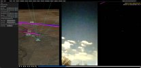
 Mick West replied to the thread Maybe a drone? Spotted in Rio Rancho New Mexico. 01/25/2026 6:58PM..But the chopper N911ZZ does slightly later, and the motion matches perfectly. The zooming in and out masks it a lot. https://www.metabunk.org/sitrec/?custom=https://sitrec.s3.us-west-2.amazonaws.com/1/Rio Rancho Helicopter/20260216_205332.js...
 -
Mick West replied to the thread Maybe a drone? Spotted in Rio Rancho New Mexico. 01/25/2026 6:58PM..Identified the stars, none of the tracks you identified there come close, viewed from that location. The orientation seems right, meaning the time is about right
-
-
Mick West replied to the thread Maybe a drone? Spotted in Rio Rancho New Mexico. 01/25/2026 6:58PM..40 seconds in, looks like six stars are visible.
-
-
Mick West replied to the thread Sitrec Tutorial Videos.Source: https://www.youtube.com/watch?v=QB7Nkz-g7EY
-
Mick West replied to the thread Syria UAP 2021- Apparent Instantaneous Acceleration.Hah, I forgot I made this video talking about my balloon experiment. Source: https://www.youtube.com/watch?v=snwqUpQ6oSE
-
Mick West replied to the thread Syria UAP 2021- Apparent Instantaneous Acceleration.Simulated IR (BLK hot) view of an irregular mylar balloon over the desert Note in both videos, the balloon is not moving at all. And over some mountains in California...
-
Mick West replied to the thread Syria UAP 2021- Apparent Instantaneous Acceleration.It was asked why a balloon would look like that. Here's a video I shot, white is cold. This is a mylar balloon in my backyard. It reflects both the sky and the ground. You see the sky as a very cold shape, not that different from what we...
-
Mick West replied to the thread Syria UAP 2021- Apparent Instantaneous Acceleration.There's some oddness going on with the framerate and the different versions. The one that @TheCholla is using for his graph is my retimed 50% one - which was the clip labeled "50%" in the Corbell video. I put that together with the 25% video and...
-
Mick West replied to the thread Syria UAP 2021- Apparent Instantaneous Acceleration.Sorry, yes, posted that before dinner time. https://www.metabunk.org/sitrec/?custom=https://sitrec.s3.us-west-2.amazonaws.com/1/syria%20with%20Flight%20Sim%20Track/20260212_192030.js
-
Mick West replied to the thread New Feature Sitrec: Accurate Moon Phases.Yeah, I use log for the depth buffer. I'll get around to it.
-
Mick West replied to the thread New Feature Sitrec: Accurate Moon Phases.Yeah, me. Actually, I DO account for libration, but not, I fear entirely accurately. The reason being I don't render a full 3D model of the entire solar system. The stars and planets, and the moon, are rendered at a fixed distance on a...
-
Mick West replied to the thread Syria UAP 2021- Apparent Instantaneous Acceleration.I don't think syncing the frame rate eliminates raster lines, unless you mean interlacing. I'm not really sure about CRTs, it might be some other display technology that has a similar result. What's clear is that on some frames, part or all of...
-
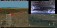
Mick West replied to the thread Syria UAP 2021- Apparent Instantaneous Acceleration.Fixed! Source: https://www.youtube.com/watch?v=sQAIVXGsgnI Early track isn't perfect, but it all looks a lot better than before. I added a HD overlay from Apple Maps at the end.
-
Mick West replied to the thread Syria UAP 2021- Apparent Instantaneous Acceleration.I have figured it out! It was NOT the right place, this is. The UI is using a fixed elevation of 1725 feet instead of a DEM (digital elevation model). So the target ground track is at 1725 feet, which is actually underground. And the altitude...
-
-
Mick West replied to the thread FAA closes El Paso and New Mexico airspace for 10 days.The one you posted. That the shutdown was because of a cartel drone incursion. Source: https://x.com/SecDuffy/status/2021594420806639787