Space Station Photos Disprove the "Flat Earth" Theory

Mick West

Administrator
Staff member
Space-Station-Frames-aligned2.gif

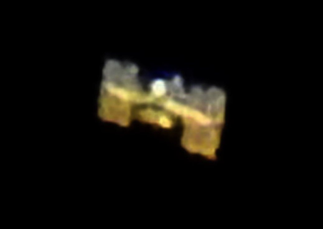
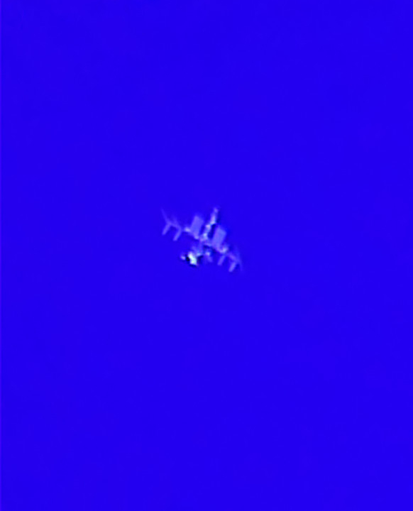
The above sequence of images is the international space station. I took them on Saturday, May 28th 2016, at 9:28PM in the Northern California town of Shingle Springs (near Sacamento). They are not very good, but you can still make out the general shape of the ISS, with the central body, and the solar panels off to the side.

[Update] And here's one I took on Sept 29, 2016, from the same location, with a bigger zoom. Discussed here: https://www.metabunk.org/how-to-tak...nternational-space-station-with-a-p900.t7986/


While I took the photos purely out of personal interest, and as a photography challenge, it struck me after that it might be yet another piece of irrefutable evidence that the Earth is not flat. A brief search shows I was not the first to think of this:

20160530-094655-r08va.jpg
Content from External Source
Perhaps the reason why this evidence is ignored is that it's hard to duplicate. You can't exactly take out your iPhone and take these photos. The ISS is 250 miles above the surface of the Earth, and mostly looks like a bright star or planet moving across the sky.

However, it's quite possible to take recognizable photos of the ISS without a telescope. I took my images with a regular Canon DSLR with a 500mm zoom lens, you just have to use manual settings to get a reasonable exposure (F/8, 1/250th, ISO 400, handheld, prefocussed using Venus then switched to manual).

You can even take (better) photos with a $500 camera, like the Nikon P900, which has an 83x optical zoom:
http://www.diyphotography.net/international-space-station-captured-nikon-p900s-monster-zoom/

THE INTERNATIONAL SPACE STATION AS CAPTURED WITH THE NIKON P900’S MONSTER ZOOM

February 9, 2016 · Liron Samuels


Shortly after its announcement I read a review of the Nikon P900 super-zoom bridge camera, where the author excitedly said it can be used to shoot objects as far as ten miles away.

Judging by this photo of the International Space Station, captured by Naftali Maimon, I’m happy to say the P900’s 83x 2000mm-equivalent zoom is also capable of snapping photos of objects 250 miles away.

That’s right, this photo was captured with a $597 bridge camera!
Content from External Source
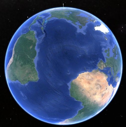
The ISS is particularly interesting as it would be impossible to fake on a "flat earth". It's appearance at any location is precisely predictable, but only if it's orbiting a globe shaped Earth at a certain speed, and at a certain altitude.

The altitude in the above animation is exaggerated, but the path is basically what the ISS takes, and as it's so low it's only really close to any one particular area of the earth (in a way it can be easily photographed at a sensible time) every few weeks.

You can find out when it's going to be visible by subscribing the the NASA "Spot the Station" site, which can email you whenever there's going to be a good flyover, or just give you a list of all upcoming times when it will be visible, for example, near me:
https://spotthestation.nasa.gov/sig...ion=California&city=Cameron_Park#.V0x_X5MrLmE

20160530-110004-r8tvb.jpg

This show (in red) the time of the flyover I photographed. The 9:25 time is when it is first visible over the horizon (10° above South West). It starts out as a disappointing slow moving dim dot, but quite quickly gets higher, brighter and faster. A "good" sighting would be anything over 45° Max Height, but the closer to 90° the better.

Notice that you can generally see the ISS three or four times a day, or at least once or twice when it's visible at night (usually low on the horizon, but still there). The effort required to fake these appearances all over the world would be impossible in itself, never mind being actually physically impossible.

[Minor note: the "Max Height" and where I say "high" or "low" refer only to the angle above the horizon. The actual altitude of the ISS is pretty much fixed at around 249 miles (400km), with a gradual downwards drift, and occasional adjustment burns of a few km every few months. But it does not vary visibly in altitude ]

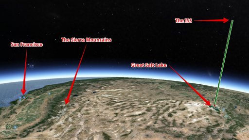
Simpler evidence is the fact that the ISS, even to the naked eye, rises up over the horizon, gets bigger as it gets closer, and then descends over the horizon. All of this it does only in a way that works on a spherical Earth. If it were being faked with a flying model, then it would actually have to rise up from the ground 250 miles away from me, fly 250 miles up in the air overhead, then fly down the other side. Not only that, but the people 250 miles away from me would have to see this huge model fly up in the air. That would basically be the entire population of San Francisco. Obviously that did not happen, and they simply see it fly overhead like everyone else.

Of course there are many irrefutable proofs that the Earth is not flat. Ultimately one more isn't going to make a difference to the true-believer. There are people who simply think that everything in the world is fake to some degree or another. But for regular folk who have simply been taken in by the theory, then one more thing might be helpful. Especially if they can take the photos themselves.

You can see a collection of much better photos taken from the ground by Mike Tyrell, here:
http://www.astrospider.com/


For a discussion on how to take these photos, see:
https://www.metabunk.org/how-to-tak...nternational-space-station-with-a-p900.t7986/
 
Last edited:
From the other end, the view from the ISS is sometimes confusing to people as they often use a very wide angle lens, which greatly exaggerates the curvature of the Earth, making it look like the photo were taken from a much higher spot, like this 16mm shot.

http://earthobservatory.nasa.gov/Features/EdLu/

This is the broadest view of Earth that an astronaut can get from the International Space Station. Ed took this view of the “Big Blue Beach Ball” using a wide angle lens while the Station was over the Pacific Ocean. In the foreground are the atolls of Tabitueua and Onotoa.ISS007-E-7304 (June 13, 2003, 16 mm lens)
Content from External Source
The human eye is much closer to a 50mm lens, so what the astronauts see is more like:


Ed took this photograph of the Earth’s horizon from a spacecraft position over Dodge City, Kansas, looking westward out the window. In the lower right is the Great Salt Lake. At the left side in the distance are the Sierra Nevada Mountains with elevations between 12,000 and 15,000 feet, and coastal California. ISS007-E-9986(July 11, 2003, 50 mm lens)
Content from External Source
This shot gives a better idea of how little of the world is actually close enough to the ISS to take good photos of it at any one time. Here I've recreated it with a 40° FOV transparent image overlay in Google Earth:

20160531-164601-k78i4.jpg


Here's a shot of the Earth, with a 250 mile high pin stuck to the east of the Great Salt Lake, at the viewpoint.
20160531-165853-tpw0l.jpg

The area outlines in green is the area in the photo.


The top of that "pin" is where the ISS would be when Ed took the photo. A closer look shows the perspective:


From the Great Salt Lake to the San Francisco coast is about 550 miles
 

Attachments

  • 20160530-104757-8a5y5.jpg
    20160530-104757-8a5y5.jpg
    135.5 KB · Views: 596
  • 20160530-105008-olj62.jpg
    20160530-105008-olj62.jpg
    366.9 KB · Views: 719
Last edited:
I recommend the Sputnik! app for the iPhone. It's free. It gives predictions for visible ISS passes and Iridium flares. It allows you to set a 10 minute reminder. Ensure location service is enabled.

In a recent debate with a flat earther I recommended he get the app, find a convenient ISS pass, and go outside and watch it. He asked why he should do that since the ISS doesn't exist.

I just added info to the OP for the NASA Spot the Station site:
https://spotthestation.nasa.gov/

Iridium flares (a reflection off an Iridium communication satellite) are also very cool. Perhaps less compelling than the ISS, as they are "just" a point of light to most cameras.
 
There's even a few handheld videos of the ISS shot with P900 or similar:


This video shows the flyover speed quite nicely. This is a very close flyover, high angle.
 
That Nikon P900 looks amazing. Good camera for plane spotting, too.
A decent video tripod fluid head (smoother tracking) could help even more.
At a current price of $600.....it's cheaper than most mid-size telephoto lenses.
(changed the video to a better one...)
 
Last edited:
[Minor note: the "Max Height" and where I say "high" or "low" refer only to the angle above the horizon. The actual altitude of the ISS is fixed at 249 miles (400km)]

Not quite true: the altitude of the ISS fluctuates by a few kilometres (~1%), as it is low enough for atmospheric drag to slow it down and pull it into a lower orbit. It has to fire its boosters periodically to adjust the altitude, as can be seen in this graph of altitude over time:

upload_2016-5-31_9-59-44.png

http://heavens-above.com/IssHeight.aspx?lat=0&lng=0&loc=Unspecified&alt=0&tz=UCT
 
Here's one of my videos of ISS with the space shuttle Atlantis docked to it for the final time, on STS-135.

High resolution stacked still image:

https://www.metabunk.org/data/MetaMirrorCache/51838cf05ce398915459dc54e2d40c15.jpg

Since there were no evening passes available during STS-135 from my location in Florida, I had to track it in broad daylight. Fortunately ISS is so bright you can actually spot it even over an hour after sunrise if you know right where to look. For tracking it through the telescope I used Brent Boshart's satellite tracking program, which commands my LX200 to slew to the coordinates for ISS predicted by its orbital elements. You have to manually adjust it to center it in the video image - "open loop" tracking is good enough to reliably put it in the viewfinder, but to get it centered at high magnification you need to compensate for slight tracking and timing errors. Open loop tracking means that input goes into the telescope (coordinates based on the orbital elements) but there is no evaluation of the "output" of how the telescope is actually tracking in order to correct further inputs to the telescope. With Brent Boshart's Satellite Tracker you have to manually "close the loop" yourself with manual corrections to the tracking.

I'm currently developing my own "closed loop" tracking software which uses a video camera viewfinder to automatically guide on bright, fast-moving objects such as rockets and satellites. My goal is to make ISS tracking somewhat "idiot-proof." It took me a few years to get good enough with Brent Boshart's software to reliably track ISS at high magnification - manual correction takes some getting used to, and I had to rig up a video viewfinder anyway to make it work reliably. Ideally my program will enable "two click" automated ISS tracking. Click once to start tracking based on the orbital elements, then click on ISS in the viewfinder to center it up automatically and maintain "closed loop" tracking for either photography/videography through the main telescope at high magnification, or even just visual observing through the eyepiece for your own enjoyment. No photo can do true justice to the view through the eyepiece. The vibrant color of the solar panels and the metallic shine of the habitat modules is a beautiful sight to behold.

I've tested my software on rocket launches and it has worked well for that purpose, but I'm still writing the code for tracking satellites like ISS based on their orbital elements before automated tracking can take over.

Once the satellite tracking code is completed I'll start porting the program to other kinds of telescopes; right now the telescope communication code is written exclusively for the LX200 classic. The program also allows for manual variable motion control using a joystick, a function that normally isn't possible with the classic LX200 (direct drive rate control wasn't implemented in the API until the newer autostar LX200s came out).
 
I wish it were irrefutable proof - but since other vids and pictures have been labelled fake or even holograms, I doubt it.

My latest tack is to challenge them to make an ossery/tellurion. If it's so easy to make one for the "fake" round Earth, should be even easier for the "real" flat Earth.

But, as we all know, totally impossible.

PS As a first time poster I should say - great work Mick, and the rest. So many wonderful threads to peruse! :)
 
I wish it were irrefutable proof - but since other vids and pictures have been labelled fake or even holograms, I doubt it.
The proof here is not really my photos, but rather the fact that any flat Earth believer could take such photos.
 
The proof here is not really my photos, but rather the fact that any flat Earth believer could take such photos.
Or just stand outside and watch it with the naked eye. The ISS is a bright object, with a magnitude as high as -5, and regularly greater than -3 on favourable passes. That is considerably brighter than any star in the sky, and on a par with the brightest planet (Venus). If you are looking up at the right time and the sky is clear, you literally can't miss it!

Seeing the shape of the ISS in photos is neat, but surely standing in your garden and seeing it track across the sky, exactly where it should be to the second, ought to convince people just as well.

Edit to add this picture, which I took on Christmas Eve 2014. The long streak is the ISS, captured with a long exposure.


The time of the passover was widely reported in advance, eg: http://www.telegraph.co.uk/news/new...a-aka-the-ISS-flying-by-on-Christmas-Eve.html

upload_2016-6-3_12-17-41.png
 
Last edited:
Seeing the shape of the ISS in photos is neat, but surely standing in your garden and seeing it track across the sky, exactly where it should be to the second, ought to convince people just as well.
You'd think so, wouldn't you? But I doubt it somehow. I'd bet money they could come up with dozens of reasons why seeing a light in the sky which corresponds where the ISS is supposed to be doesn't prove anything.
 
You'd think so, wouldn't you? But I doubt it somehow. I'd bet money they could come up with dozens of reasons why seeing a light in the sky which corresponds where the ISS is supposed to be doesn't prove anything.

Actually, when looking at my photo and comparing to a star chart, I find that the ISS wasn't where it was supposed to be! :confused:

Here's a comparison of my photo with the star chart from Heavens-Above, set to my exact location, for the pass on 24 Dec 2014. It's quite a way out. Anyone know why? The track of the ISS is considerably higher in the sky than it apparently should have been, passing almost through the distinctive diamond shape of Delphinus.

upload_2016-6-3_13-1-39.png

Zooming in on the area of Delphinus:


isstracks.jpg
 
Last edited:
Actually, when looking at my photo and comparing to a star chart, I find that the ISS wasn't where it was supposed to be! :confused:

Here's a comparison of my photo with the star chart from Heavens-Above, set to my exact location, for the pass on 24 Dec 2014. It's quite a way out. Anyone know why? The track of the ISS is considerably higher in the sky than it apparently should have been, passing almost through the distinctive diamond shape of Delphinus.

upload_2016-6-3_13-1-39.png

Zooming in on the area of Delphinus:


isstracks.jpg

Where are you in relation to the track? If you weren't right under the track the parallax would shift the apparent location.
 
Where are you in relation to the track? If you weren't right under the track the parallax would shift the apparent location.
Well, I assumed that the sky chart would show the track as it appears from my location, taking into account the altitude of the ISS. These are the details of the pass as shown on Heavens Above:

upload_2016-6-3_13-17-5.png

The altitude difference between where it should have appeared and where it actually appeared is about 15 degrees.

This shows that the ground track was some distance away:

upload_2016-6-3_13-20-14.png
 
When did you upload that chart? Your photo is from 2014 but when did you take a screencap of that chart? Did you take at the same time you took the photo or just recently?
I just took a picture of the chart today. Heavens-Above doesn't seem to give a search by date facility but it gives a 10-day list of ISS passes and you can click back 10 days at a time.

I won't post the direct link as the URL contains my co-ordinates but if you go to http://www.heavens-above.com and then click "ISS" under the "10-day predictions for satellites of special interest" header, you can then move back in time using the arrow buttons.

Heavens-above doesn't use historic orbit elements for ISS passes in the past; they use the current orbit elements. If you want you can PM me your coordinates and I'll find the historic orbit elements and plug em into Stellarium and make a screencap of the pass using the proper orbit elements of the time.
 
Heavens-above doesn't use historic orbit elements for ISS passes in the past; they use the current orbit elements. If you want you can PM me your coordinates and I'll find the historic orbit elements and plug em into Stellarium and make a screencap of the pass using the proper orbit elements of the time.
Ah, now that makes sense. It even says "Epoch: 03 June" on the chart.

I remember looking at Heavens-Above before that pass so I knew where the ISS would be, and I don't recall a discrepancy at the time.

I even posted the graph above showing boosters being fired to regain altitude but hadn't considered the effect on the orbital track.

Thanks for the explanation.
 
Last edited:
I wish it were irrefutable proof - but since other vids and pictures have been labelled fake or even holograms, I doubt it.

I've seen two hipothesis given by flatearthers concerning the ISS:

1- The ISS is in really a Lockheed U-2 spyplane. The reason to this be so is the similarities of ISS photos and the plane itself.


The problem is: how the U2 makes to continually flies above the Flat Earth? What it uses as fuel to do so?

2- And the another hipothesis is just the holograms how you said. But to prove this, it would be necessary demonstrate the existence of flying reflectors and screens- and how to make it to keep continually in the skies- to produce the holograms.
 
I've seen two hipothesis given by flatearthers concerning the ISS:

1- The ISS is in really a Lockheed U-2 spyplane. The reason to this be so is the similarities of ISS photos and the plane itself.

I don't think the ISS is equipped with ADS-B.

NASA806.jpg
 
1- The ISS is in really a Lockheed U-2 spyplane. The reason to this be so is the similarities of ISS photos and the plane itself.
http://www.stripes.com/news/air-force-plans-drone-upgrade-to-replace-u-2-planes-1.272289
Link in case embedding is blocked:


The U-2 has a lot of configurations, but none of them remotely resemble the distinct shape of the ISS main truss and solar panels. This is the most similar one I can find, and still, literally no resemblance.

In addition, the U-2 can't move even a tiny fraction of the speed necessary to simulate the passing of the ISS. No aircraft can. Let alone that the ISS has been visible from the ground for 18 continuous years, somewhat exceeding the U-2's endurance of 12 hours.
 
Last edited:
If it were a high altitude airplane then "They" would need one airplane for every visible satellite for every single person who has ever accessed any website or who has downloaded any of the numerous smartphone apps and planetarium programs like Stellarium, Celestia, etc, showing satellite positions. Geosynchronous satellites and satellites in highly elliptical near apogee would have to be mimicked by helicopters. All of these aircraft would have to be equipped with very narrow beam searchlights pointed directly at the intended observer otherwise the night sky would be lit up by hundreds of "other people's fake satellites".

Heavens-above listed over 400 visible satellite passes of magnitude 5.0 or brighter for my location tonight. That is the limit of naked eye visibility with a small amount of light pollution. Add a small telescope or binoculars and you'll be able to spot thousands of satellites in a single night.

And "They" would need at least two people working shifts to constantly spy on all of the aforementioned people in case they decide to travel somewhere so the spies can call in for a revised flight plan.
 
And "They" would need at least two people working shifts to constantly spy on all of the aforementioned people in case they decide to travel somewhere so the spies can call in for a revised flight plan.

Or they could just hire Aliens... may as well throw the kitchen sink in while we're at it.
 
If it were a high altitude airplane then "They" would need one airplane for every visible satellite for every single person who has ever accessed any website or who has downloaded any of the numerous smartphone apps and planetarium programs like Stellarium, Celestia, etc, showing satellite positions. Geosynchronous satellites and satellites in highly elliptical near apogee would have to be mimicked by helicopters. All of these aircraft would have to be equipped with very narrow beam searchlights pointed directly at the intended observer otherwise the night sky would be lit up by hundreds of "other people's fake satellites".

Heavens-above listed over 400 visible satellite passes of magnitude 5.0 or brighter for my location tonight. That is the limit of naked eye visibility with a small amount of light pollution. Add a small telescope or binoculars and you'll be able to spot thousands of satellites in a single night.

And "They" would need at least two people working shifts to constantly spy on all of the aforementioned people in case they decide to travel somewhere so the spies can call in for a revised flight plan.
Surely they would need a lot more planes than that! The angle of view would be completely wrong for most observers, since the UK would be much lower than the ISS, and in many cases in the wrong direction. Not that I would expect hardcore flat earthers to worry about that.

I referred to drones when i drew this, but the argument is the same for U2s or other aircraft. https://www.metabunk.org/data/MetaMirrorCache/2f5c12991748696ba900d303093ad8a0.gif

I do Not think its possible to see the space station from 300 miles away if it was going 17000 miles per hour since we can hardly see a plane at 40 000 feet .....
 
I do Not think its possible to see the space station from 300 miles away if it was going 17000 miles per hour since we can hardly see a plane at 40 000 feet .....
Sorry, you need some evidence, especially to convince me that I couldn't see it when I have! Why should it's orbital speed stop us from seeing it? Oh, and we can see planes at high altitudes.

There is no question that many people have seen it. Try it yourself! But flat earthers cimplicitly admit that this true, by trying to explain that away as "drones" or "U2s" or whatever. The point of my animation is to show oneof a number of reasons why that simply couldn't work.
 
I do Not think its possible to see the space station from 300 miles away if it was going 17000 miles per hour since we can hardly see a plane at 40 000 feet .....300 miles is much too far to see a 356 foot space station .its impossible ..its like seeing a small house in montreal from the cn tower
 
Sorry, you need some evidence, especially to convince me that I couldn't see it when I have! Why should it's orbital speed stop us from seeing it? Oh, and we can see planes at high altitudes.

There is no question that many people have seen it. Try it yourself! But flat earthers cimplicitly admit that this true, by trying to explain that away as "drones" or "U2s" or whatever. The point of my animation is to show oneof a number of reasons why that simply couldn't work.
I have seen it last year ...or i thought it was it .....it looked like the pics ....but then i realized that a plane at 40 000 feet is barely recognizable ...and this is supposed to be 300 miles away ...i live in oronto i cannot see montreal from here .
 
I have seen it last year ...or i thought it was it .....it looked like the pics ....but then i realized that a plane at 40 000 feet is barely recognizable ...and this is supposed to be 300 miles away ...i live in oronto i cannot see montreal from here .
I saw it from a beach in Suffolk. Have you tried ISS Tracker or a similar website, or a smartphone app?

I'm sure you aren't serious about Ontario and Montreal. Aside from the Earth's curvature, there tend to be hills and bits of uneven ground in the way... Not quite the same as looking up through a clear sky into near earth orbit.
 
I do Not think its possible to see the space station from 300 miles away if it was going 17000 miles per hour since we can hardly see a plane at 40 000 feet .....300 miles is much too far to see a 356 foot space station .its impossible ..its like seeing a small house in montreal from the cn tower

When you see it with the naked eye it just looks like a point of light. You need very powerful magnification to make out any detail.

You see it because it is lit by the sun, and the sky is dark.

You can see a white car on a dark background from a mile away, right? Well the ISS's is over 35,000 square feet in area, a car is just about 100 square feet. So the ISS is reflecting a LOT more light, and since it's dark your eyes are WAY more sensitive. So you can see it.
When I saw it i was with friends we all saw it ....it looked like the space station perfectly ...but then i realized that it couldn't be 270 miles away we were not looking with any binoculars or telescope or camera just with the naked eye ...this is very suspicious ...it is too far away to make it out as clearly as we saw it ...this is my point ...270 miles and the dimensions are 108.5 meters by 72.8 meters....but 270 miles away ? I'm not sure if its real i don't think the pics or seeing it makes it real ...then there is the problem with it being about 3500 degrees in the sunlight etc ..maybe thats off topic too ..just throwing that out there
 
Back
Top