
Bunkmeister
New Member
Inspired by YouTuber Miles Davis's observation of distant peaks relative to a known midway elevation marker, I was considering conducting a similar observation over Lake Michigan on a future visit to Chicago and Southeast Michigan/Indiana (Michiana, as it is sometimes referred).
I would like to establish a viewing point at equal height to the top of the Michigan City, IN lighthouse with a line of sight to the Chicago skyline. The goal would be to show how much the buildings have dropped relative to the lighthouse.
The line of sight distance to Chicago is about 39 miles:

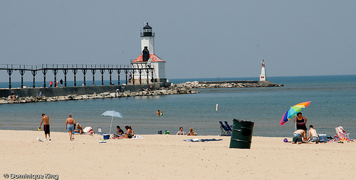
Here is the lighthouse:
Based on the NOAA navigation chart (#14905), I am showing a lighthouse height of 55 feet (wikipedia says focal height of 50):

Using elevation finder, I believe I have identified a ridge which will get me sufficient elevation as well as line of sight, and this is its approximate location:

It is winter so the leaves and foliage will be gone. There is no fencing along that ridge. It probably is zoo property, but I plan to ask permission first.
My plan is to use a water level like the one seen below to determine my level with the lighthouse.

Once a level viewing height has been established, I would like to observe where the Chicago skyline lies in relation to the lighthouse. Hopefully the viewing conditions will cooperate.
I am just wondering if there are any problems or pitfalls with this proposed observation and my preliminary plan. Should I expect to see all the buildings below the top of the lighthouse? Constructive criticism is welcome. Thanks.
I would like to establish a viewing point at equal height to the top of the Michigan City, IN lighthouse with a line of sight to the Chicago skyline. The goal would be to show how much the buildings have dropped relative to the lighthouse.
The line of sight distance to Chicago is about 39 miles:
Here is the lighthouse:
Based on the NOAA navigation chart (#14905), I am showing a lighthouse height of 55 feet (wikipedia says focal height of 50):
Using elevation finder, I believe I have identified a ridge which will get me sufficient elevation as well as line of sight, and this is its approximate location:
It is winter so the leaves and foliage will be gone. There is no fencing along that ridge. It probably is zoo property, but I plan to ask permission first.
My plan is to use a water level like the one seen below to determine my level with the lighthouse.
Once a level viewing height has been established, I would like to observe where the Chicago skyline lies in relation to the lighthouse. Hopefully the viewing conditions will cooperate.
I am just wondering if there are any problems or pitfalls with this proposed observation and my preliminary plan. Should I expect to see all the buildings below the top of the lighthouse? Constructive criticism is welcome. Thanks.