
StarGazer
Member
This is simply not the case when we carefully analyse videos from rocket launches where we have a clear view of the horizon and a possible view of Earth's Equatorial Bulge.A popular Flat Earth claim is that the horizon doesn't drop and that the Earth is levelled on 360° circle.
Here are two very good examples of horizon drop:
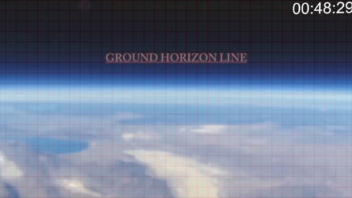
1. DIY Two Stage Spining Rocket to 96 000 feet (29 261 meters) launched on September 19, 2015 from Nevada's Black Rock Desert.
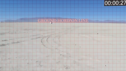
Ground Horizon Before Liftoff
48 Seconds Into The Launch
We can clearly see as the DIY rocket ascends on a pretty much steady 360° spin, that the horizon does drop.
2. GoFast Spinning Rocket to 73.1 miles (117.6 km) launched on July 14, 2014 from White Sands Missile Range (WSMR), New Mexico.
In less than 2 seconds after liftoff we can detect a horizon drop.
3 min and 41 seconds into the video is from where I presented the horizon drop.
To Summarise:
2. GoFast Spinning Rocket to 73.1 miles (117.6 km) launched on July 14, 2014 from White Sands Missile Range (WSMR), New Mexico.
In less than 2 seconds after liftoff we can detect a horizon drop.
3 min and 41 seconds into the video is from where I presented the horizon drop.
To Summarise:
1. If we superimpose a grid on top of a footage, how many squares should the grid have on the horizontal and on the vertical?
My estimate is that it depends on the focal length of the camera and the crop factor.
2. What are the degrees of drop by altitude and with what accuracy we can measure those degrees of drop when we know that different cameras have different specifications?
My estimate is that it depends on the focal length of the camera and the crop factor.
2. What are the degrees of drop by altitude and with what accuracy we can measure those degrees of drop when we know that different cameras have different specifications?
I made some estimates of the degrees of drop, but I cannot answer if the camera specs would give a small or large margin of error for the measurements.- Altitude 1 km: Distance to Horizon - 112.9 km, Horizon Drop - 0.940 degrees
- Altitude 10 km: Distance to Horizon - 357.3 km, Horizon Drop - 2.970 degrees
- Altitude 20 km: Distance to Horizon - 505.5 km, Horizon Drop - 4.198 degrees
- Altitude 30 km: Distance to Horizon - 619.3 km, Horizon Drop - 5.139 degrees
- Altitude 40 km: Distance to Horizon - 715.4 km, Horizon Drop - 5.931 degrees
- Altitude 73 km: Distance to Horizon - 967.7 km, Horizon Drop - 7.997 degrees
- Altitude 117.6 km: Distance to Horizon - 1230.4 km, Horizon Drop - 10.126 degrees
It seems to me that the DIY rocket rises almost on a perfect perpendicular trajectory showing a levelled horizon drop, except a slight elevation (Equatorial Bulge?) which should be due south, until it starts to swing loosing that levelled horizon. (By levelled I don't mean flat)
Attachments


Last edited:
")