Jimi baker's contrails

Jimi baker

New Member
Hello so-called debunkers.debunk these shots I just took a few days in a row,and days with absolutely no choke contrails at all.You should know that it takes very cold and humid conditions for contrails to Evan form,but when their flying no higher than 12-14 thousand feet in 107 degrees on the ground,well use the adiabatic rate to figure out the temps at the altitude of the planes and then explain these trails of crud.
image.jpg
 
Last edited by a moderator:
Hi Jimi,

These trails look like they are in the normal 30-40,000 feet range. Can you explain why you think they are lower?
 
Last edited:
Hello Jimi. When and where were they taken? Then perhaps we can explain.

As Mick says, what are you basing the altitude on? Did you identify the flights using Flightaware or a similar tool?

As for the temperature issue, I am going to assume you are in the USA?

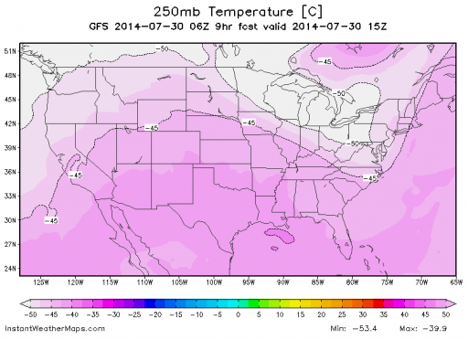
Right now, regardless of how hot it is on the ground, the temperature at 30,000 feet is -40C or below (which is the same as -40F) across the entire continental US:

Capture.PNG
 
Last edited:
these trails look like the ones I saw from my lounge window the other day that matched up to planes flying at 36,000ft.

How are you determining the height?
 
Even zooming right in on that picture I can't make out the jet. If it was at "12 to 14 thousand feet" then I would. I live under very busy skies and I can recognise what height planes are flying at. That is at cruising altitude, well above 30,000ft at a guess.
 
If it was at "12 to 14 thousand feet" then I would.

Yes, exactly. Here's a way to think about it:

Even 15 thousand feet is still less than three miles. (2.84 Statute miles). You can visit a large airport, where the runways are typically 11 to 12 thousand feet long (2 to 2.27 miles), and observe airplanes after take-off, watching from the end of the runway (from behind them). Judge the relative size of the airplane from there.

Thus, in the OP photos, if those jets (and the contrails) were at "12 to 14 thousand feet", the jets would be easily visible to the unaided eye.
 
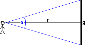
One way to think about that is to do an angular diameter comparison. There are calculators available that will make this easy (see here for example).

A 130-foot long plane flying directly overhead at 12,000 feet takes up about as much of your field of vision as a 1-foot long toy plane from 30 yards away. A 130-foot long plane that's 30,000 feet away is about the same apparent size as a 1-foot long toy plane that's 77 yards away.

 
Hello so-called debunkers.debunk these shots I just took a few days in a row,and days with absolutely no choke contrails at all.You should know that it takes very cold and humid conditions for contrails to Evan form,but when their flying no higher than 12-14 thousand feet in 107 degrees on the ground,well use the adiabatic rate to figure out the temps at the altitude of the planes and then explain these trails of crud.
image.jpg
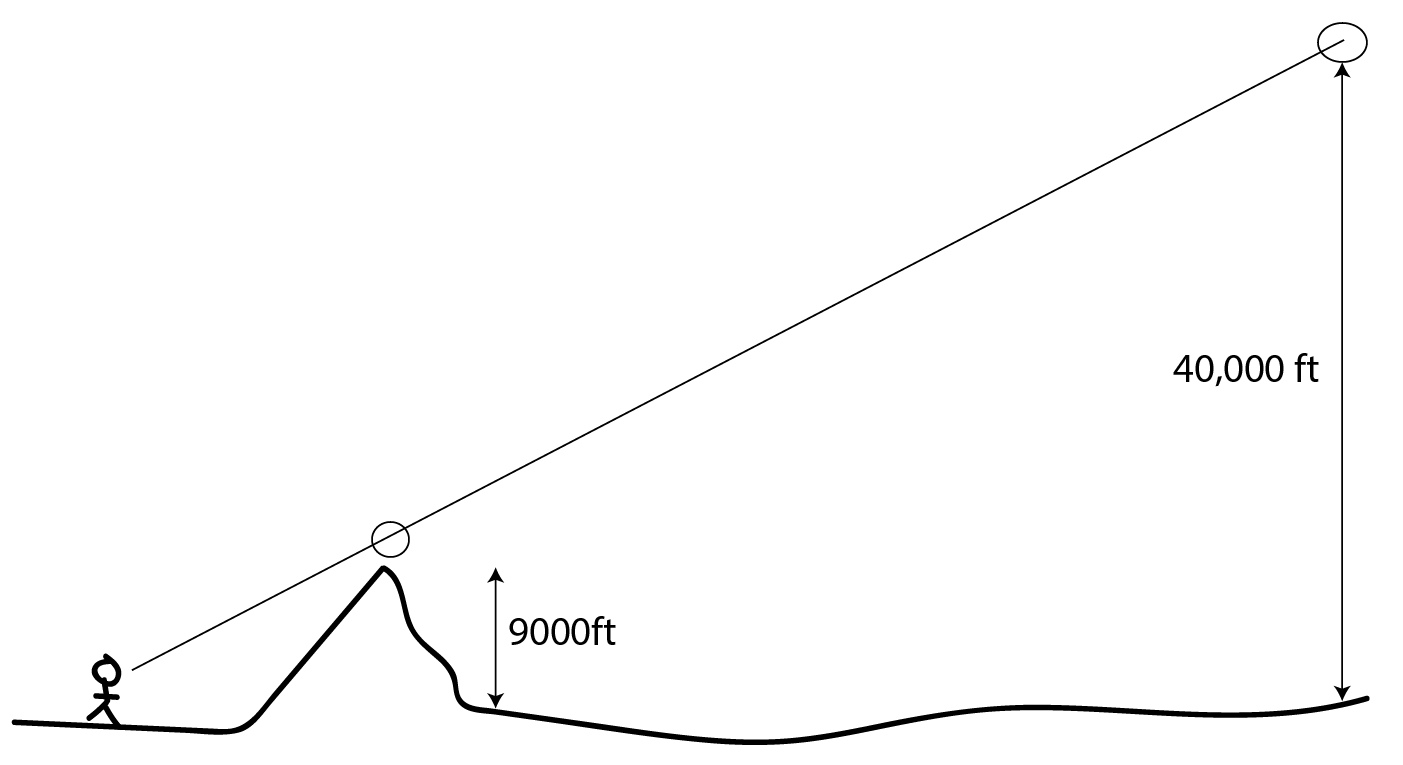
I did take both shots minutes apart.and I could clearly see the plane,and I live at the base of the sierras in Ca. Where the crest is only 9 thousand feet.using that for a measuring scale it's easy to tell what altitude their flying at.Check out bishop weather.com time-lapse and you have the high sierras for a measuring scale,Besides I've been flying since 67 and no the difference between a contrail and crop dusting at high altitude.besides check out weather modification,google it,Evan Wikipedia says they've been spraying aluminum oxide and barium along with silver iodine!!!
 
Oh yeah I,m no where near an airport,and what flight line goes along the crest of the high sierras?and they flew on off spray patterns,here's some close ups at the same place but pictures of old pictures,weather modification inc.has been in biz since 1961 .so go ahead and keep your heads in the sand,only safe place!

image.jpg image.jpg
 
Last edited by a moderator:
Oh yeah I,m no where near an airport,and what flight line goes along the crest of the high sierras?

I'm not sure exactly where you live but here is a computer generated image of most of the flights currently en route over southern California. Many of them are either arriving or departing LA, San Diego, Las Vegas and Phoenix.

map1.png

you can generate your own more current image by going to this link. http://www.theguardian.com/world/ng-interactive/2014/aviation-100-years

To mark 100 years of passenger air travel, our stunning interactive uses live data from FlightStats to show every one of the thousands of commercial planes currently in the air,
Content from External Source
 
Oh yeah I,m no where near an airport,and what flight line goes along the crest of the high sierras?and they flew on off spray patterns,here's some close ups at the same place but pictures of old pictures,weather modification inc.has been in biz since 1961 .so go ahead and keep your heads in the sand,only safe place!

image.jpg image.jpg

Cool old photos. However these are contrails, not cloud seeding. Cloud seeding is done to existing clouds, and does not leave a trail.
 
You must have amazing eyesight then. Cos I am looking at your photos and the plane isn't at all visible in them.
when you say you could clearly see the plane, could you see markings?

As for planes flying over the High Sierra's as of 14:46 2nd August 2014, I can see Alaskan Airlines Seattle to LA @35,000 feet, Vancouver to LA 39,000ft, Portland to LA @39,000ft, seattle to Orange County at 37,000ft, Burbank to Seattle @38,000ft,
Air Canada Las Vegas to Vancouver @38,000ft, and many more on a north/south ish track,with plenty more criss crossing.

a quick count up sees 28 aircraft currently over that mountain range.

if the plane in the photo is only 3,000 ft above a 9,000 ft crest, how come I can't see the mountain in the photo?
 
Hello so-called debunkers.debunk these shots I just took a few days in a row,and days with absolutely no choke contrails at all.You should know that it takes very cold and humid conditions for contrails to Evan form,but when their flying no higher than 12-14 thousand feet in 107 degrees on the ground,well use the adiabatic rate to figure out the temps at the altitude of the planes and then explain these trails of crud.

Have a look through the following Metabunk thread.

https://www.metabunk.org/threads/woodys-observations-of-contrails-in-mn.2484/

Woody had the same problem as you have of not understanding the upper air routes in his region. Be aware though even when informed of how to match up Flight Radar 24 to what he was seeing he still got very confused.

So try it yourself with time-matched images to Flight Radar 24.

http://www.flightradar24.com/

Get the app for your phone and simply point it at the aircraft in the sky.

Turn your phone or tablet into an air traffic radar and see planes around the world move in real-time. Or point your device at the sky to find out where a certain plane is going and more. Discover today why millions are already using Flightradar24.
Content from External Source
http://www.flightradar24.com/apps/

SkyVector is also a useful tool for the upper air routes.

http://skyvector.com/

So next time you see that Airbus A380 or Boeing 747 producing contrails over your region you can now match them up and see the flight data.

http://flightaware.com/live/

http://uk.flightaware.com/
 
You must have amazing eyesight then. Cos I am looking at your photos and the plane isn't at all visible in them.
when you say you could clearly see the plane, could you see markings?

As for planes flying over the High Sierra's as of 14:46 2nd August 2014, I can see Alaskan Airlines Seattle to LA @35,000 feet, Vancouver to LA 39,000ft, Portland to LA @39,000ft, seattle to Orange County at 37,000ft, Burbank to Seattle @38,000ft,
Air Canada Las Vegas to Vancouver @38,000ft, and many more on a north/south ish track,with plenty more criss crossing.

a quick count up sees 28 aircraft currently over that mountain range.

if the plane in the photo is only 3,000 ft above a 9,000 ft crest, how come I can't see the mountain in the photo?

Same routes that I see over the Willamette Valley in Oregon.
 
Oh yeah I,m no where near an airport,

Well what difference does that make? When you fly halfway across the world, for what proportion of the time are you near an airport?

In any case, planes don't leave trails when they're taking off and landing (barring very few exceptions), only when they are at cruising height!

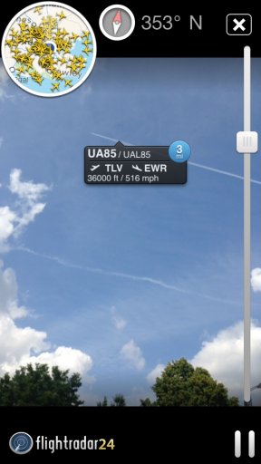
Look, here's one I snapped overhead yesterday. This was in London but look at the route: TEL AVIV to NEWARK! Both these airports are thousands of miles away but the plane is flying overhead.

image.jpg

Notice also that it is parallel to the other visible trail.
 
Where the crest is only 9 thousand feet.using that for a measuring scale it's easy to tell what altitude their flying at.

Now THAT's a photo analysis I'd love to see! I suspect we might be looking at a Father Dougal moment (sorry, in-joke for British/Irish TV fans...)
 
Oh yeah I,m no where near an airport,and what flight line goes along the crest of the high sierras?and they flew on off spray patterns,here's some close ups at the same place but pictures of old pictures,weather modification inc.has been in biz since 1961 .so go ahead and keep your heads in the sand,only safe place!

Look, we are trying to help here.

The photos you have posted thus far are (to professional eyes, like mine) images of normal cirrus clouds and contrails, ALL forming at heights well above 30,000 feet.

I've been a professional pilot for over 25 years. I've flown for over 40 years. I KNOW what clouds are supposed to look like. I KNOW what the skies are supposed to look like. The skies are COMPLETELY NORMAL!
 
Well what difference does that make? When you fly halfway across the world, for what proportion of the time are you near an airport?

In any case, planes don't leave trails when they're taking off and landing (barring very few exceptions), only when they are at cruising height!

Look, here's one I snapped overhead yesterday. This was in London but look at the route: TEL AVIV to NEWARK! Both these airports are thousands of miles away but the plane is flying overhead.

image.jpg

Notice also that it is parallel to the other visible trail.
Forgive my ignorance. Why is it unusual see a flight from Tel Aviv to Newark? I always thought flights took the most direct and efficient route
 
Forgive my ignorance. Why is it unusual see a flight from Tel Aviv to Newark? I always thought flights took the most direct and efficient route
It's not unusual at all, that's my point.

Jimi seems to think that if he's not near an airport then he won't see contrails. My point is that planes flying over my head can be flying from and to airports thousands of miles away.

I live quite near to the two main London airports. But the planes taking off and landing from them aren't at cruising altitude when they pass over, so the contrails I see aren't from them.

The east-west flight path between the Eastern USA and mainland Europe/Middle East passes over me, as does the north-south flight path from Northern UK airports down to the Mediterranean.
 
Back
Top