
Apocalyptic sounding headlines have accompanied this story about a large crack in the Earth in Mexico.

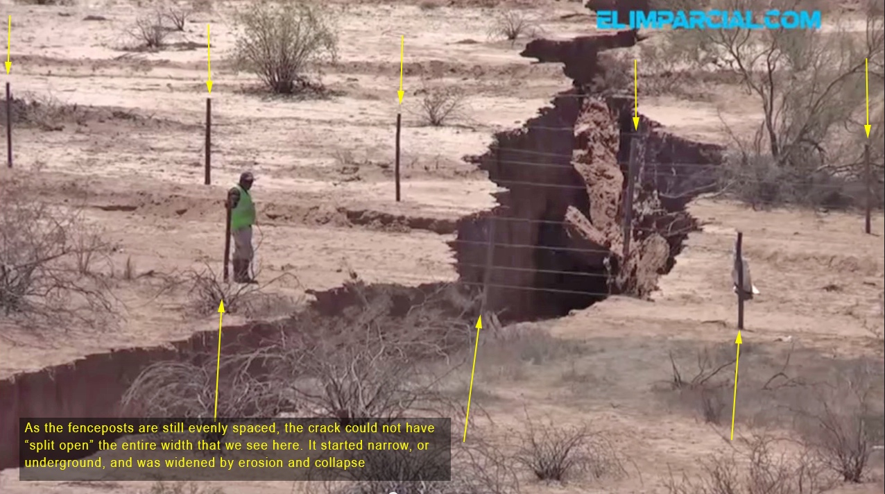
Firstly is seems almost certain that this is nothing at all to do with earthquake activity, as many headlines have suggested. The earth has not simply "split open", as the ground on both side of the crack has stayed exactly where it started. We can see here that the fence posts have not moved, instead the ground has been removed from underneath.
Instead, as you can partially see from what looks like a muddy stream in the top image, the culprit is water, as was somewhat explained in the Mexican press.
http://www.excelsior.com.mx/nacional/2014/08/21/977513
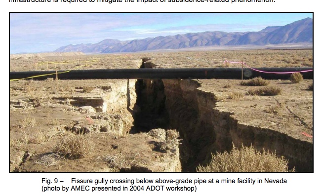
The crack is in a region of newly constructed irrigation ditches and ponds, and recent heavy rains had saturated the ground. The translation from the Spanish scientists suggests some kind of underground flow creating the crack. Certainly there has been some flow erosion. But the initial cause of the fissure seems more likely to be differential compaction. Differences in irrigation, or water extraction, combined with differences in the level of the underground bedrock, creates differences in compaction and rates of settling, eventually causing fissures, often partially or fully underground. These fissures then grow rapidly as water flows though them. It's not that uncommon, and these type of fissure have been well studied here in the US, particularly in Arizona, as in this USGS page:
http://water.usgs.gov/edu/gallery/landsubsidence-lakelucern.html
And there's a detailed explanation in this white paper from the Arizona Land Subsidence Group
http://azgs.az.gov/Earth Fissures/CR-07-C.pdf
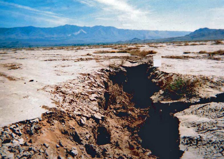
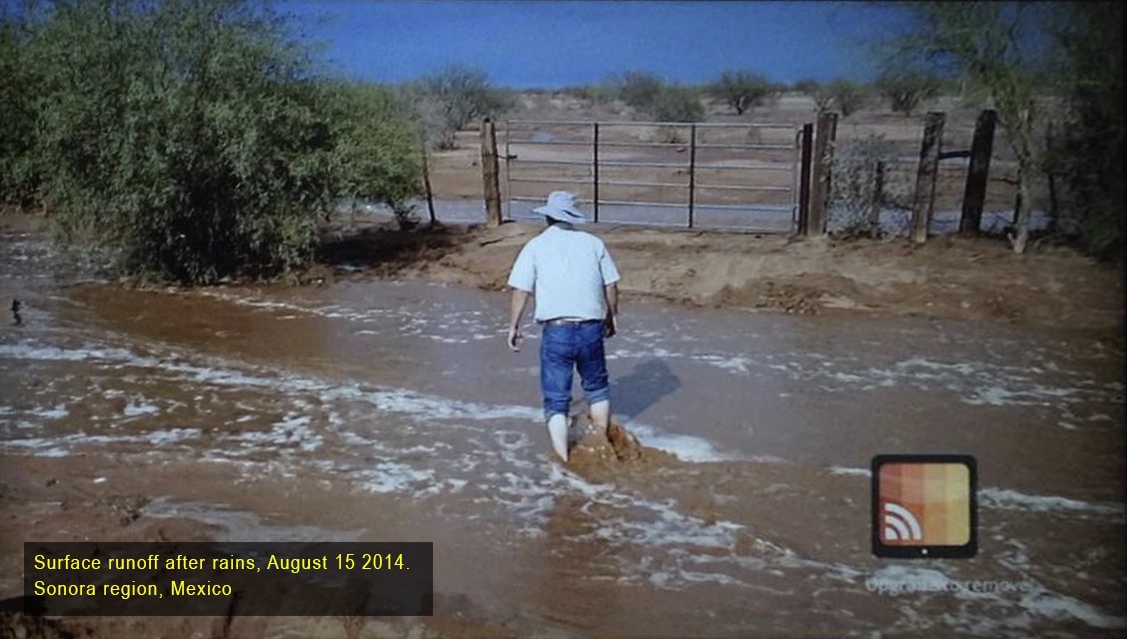
The sudden widening of the fissure coincided with heavy rains in August, as reported on local TV. This image is from roughly the same general area. Heavy summer rains and flooding are very common in the Sonora region.
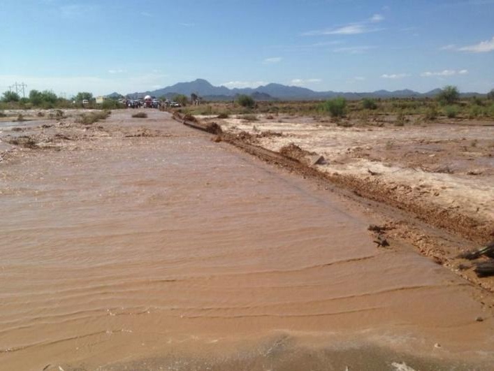
And this was the flooding August 18th 2014, in Carborca, about 100 miles to the north of the fissure.
http://www.elimparcial.com/EdicionE...an-Carretera-de-la-Muerte-por-inundacion.html
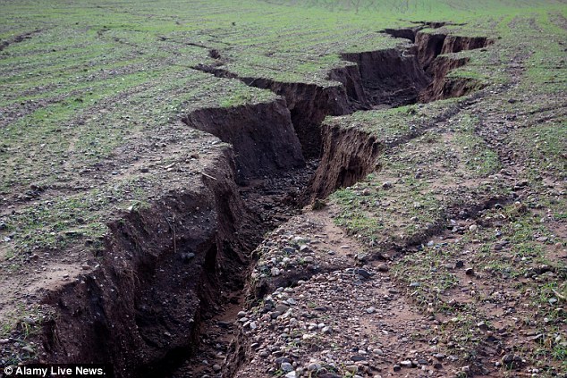
And it's not something limited to the desert. Heavy rain on a steep hillside in the UK led to very similar looking cracks earlier this year. In this case the trigger was not thought to be a fissure, but something like a rabbit burrow that allowed the rain to get a start:
http://www.dailymail.co.uk/news/art...ld-without-crops-prior-heavy-winter-rain.html
Another misconception in the press is the location of the crack, as typified here:
http://www.news.com.au/technology/e...earthquake-fears/story-e6frflp0-1227032868718
http://www.dailymail.co.uk/news/art...splits-earth-open-rural-northwest-Mexico.html
http://www.excelsior.com.mx/nacional/2014/08/21/977513
Geolocating photos is an interesting challenge, so I though I'd have a go at this one. Starting with this photo of the crack from the drone footage:
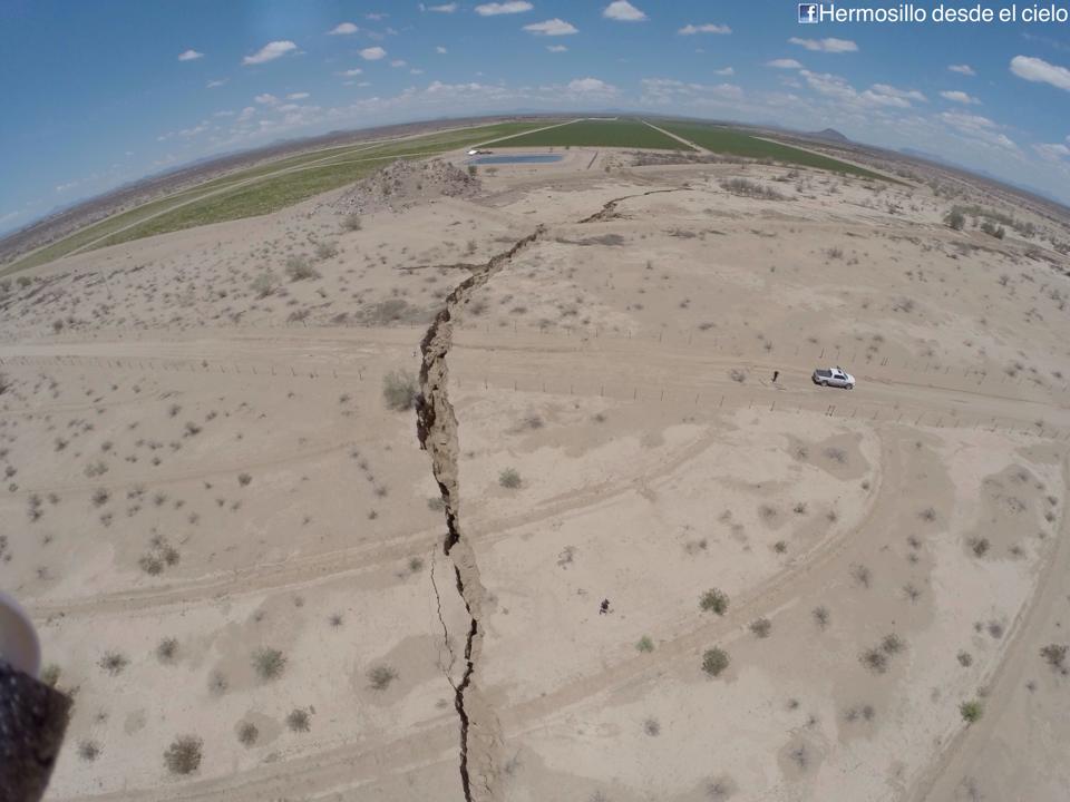
This proved a little tricky, as the fields are new, and don't show up in Google Earth. But I was eventually able to track it down by knowing which road it was on, and by looking at the pattern of brush. In particular there's four small bushes in a line just south of the road, to the right of center. And then on the other side there's four larger bushes in a line leading up to the small mound of rocks.

With this, I was able to find the precise location of the crack.

I've attached a Google Earth .kmz file with this overlay and location.
Firstly is seems almost certain that this is nothing at all to do with earthquake activity, as many headlines have suggested. The earth has not simply "split open", as the ground on both side of the crack has stayed exactly where it started. We can see here that the fence posts have not moved, instead the ground has been removed from underneath.
Instead, as you can partially see from what looks like a muddy stream in the top image, the culprit is water, as was somewhat explained in the Mexican press.
http://www.excelsior.com.mx/nacional/2014/08/21/977513
There actually seems to be two things going on here:"Definitely not a cause for alarm to the population, rather something sensational and encourage people like that sort of thing; when a fault is generated levels generally move and here we are seeing people walking at both ends of the trench, the two levels are in place, and is one of the raised blocks, or other sunk, " said Chief Regional Station of the Institute of Geology, UNAM in Hermosillo, Martin Moreno Valencia.
The specialist have conducted in-depth studies and confirmed that the ditch flows due to rainwater that infiltrates , looking natural channel through which circular removes sediment, thus creating a gap that as a matter of gravity collapses.
[Translated from Spanish]
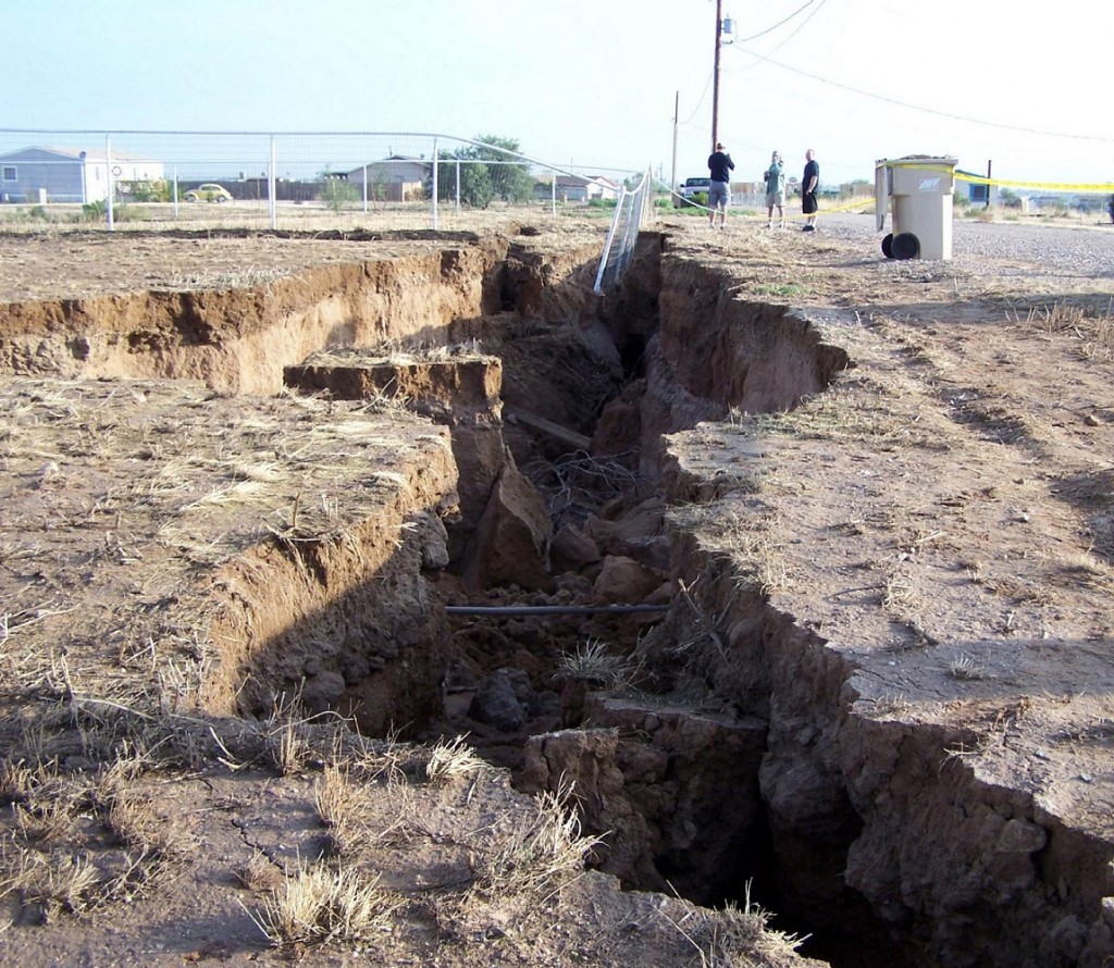
- A subsidence fissure, where irrigation caused wet areas of the region to pull away from dry areas due to differential compaction, leading to a narrow but deep fissure.
- Gully erosion, where heavy water flow, likely from rain, rapidly eroded the fissure into the shape we see above. This may happen long after the original fissure has formed.
The crack is in a region of newly constructed irrigation ditches and ponds, and recent heavy rains had saturated the ground. The translation from the Spanish scientists suggests some kind of underground flow creating the crack. Certainly there has been some flow erosion. But the initial cause of the fissure seems more likely to be differential compaction. Differences in irrigation, or water extraction, combined with differences in the level of the underground bedrock, creates differences in compaction and rates of settling, eventually causing fissures, often partially or fully underground. These fissures then grow rapidly as water flows though them. It's not that uncommon, and these type of fissure have been well studied here in the US, particularly in Arizona, as in this USGS page:
http://water.usgs.gov/edu/gallery/landsubsidence-lakelucern.html
Water Science Photo Gallery
Land subsidence: Fissures in the Mojave Desert, California
The withdrawal of groundwater near Lucerne Lake (dry) in San Bernardino County, Mojave Desert, California has caused the land to subside, with the results being the formation of fissures on the landscape. In some instances, the fissures were more than 1 meter (3.3 feet) wide and deep. Fissuring often is associated with localized differential compaction of sediments. The 5-gallon bucket can be used as a scale reference.
And there's a detailed explanation in this white paper from the Arizona Land Subsidence Group
http://azgs.az.gov/Earth Fissures/CR-07-C.pdf
The sudden widening of the fissure coincided with heavy rains in August, as reported on local TV. This image is from roughly the same general area. Heavy summer rains and flooding are very common in the Sonora region.
And this was the flooding August 18th 2014, in Carborca, about 100 miles to the north of the fissure.
http://www.elimparcial.com/EdicionE...an-Carretera-de-la-Muerte-por-inundacion.html
And it's not something limited to the desert. Heavy rain on a steep hillside in the UK led to very similar looking cracks earlier this year. In this case the trigger was not thought to be a fissure, but something like a rabbit burrow that allowed the rain to get a start:
http://www.dailymail.co.uk/news/art...ld-without-crops-prior-heavy-winter-rain.html
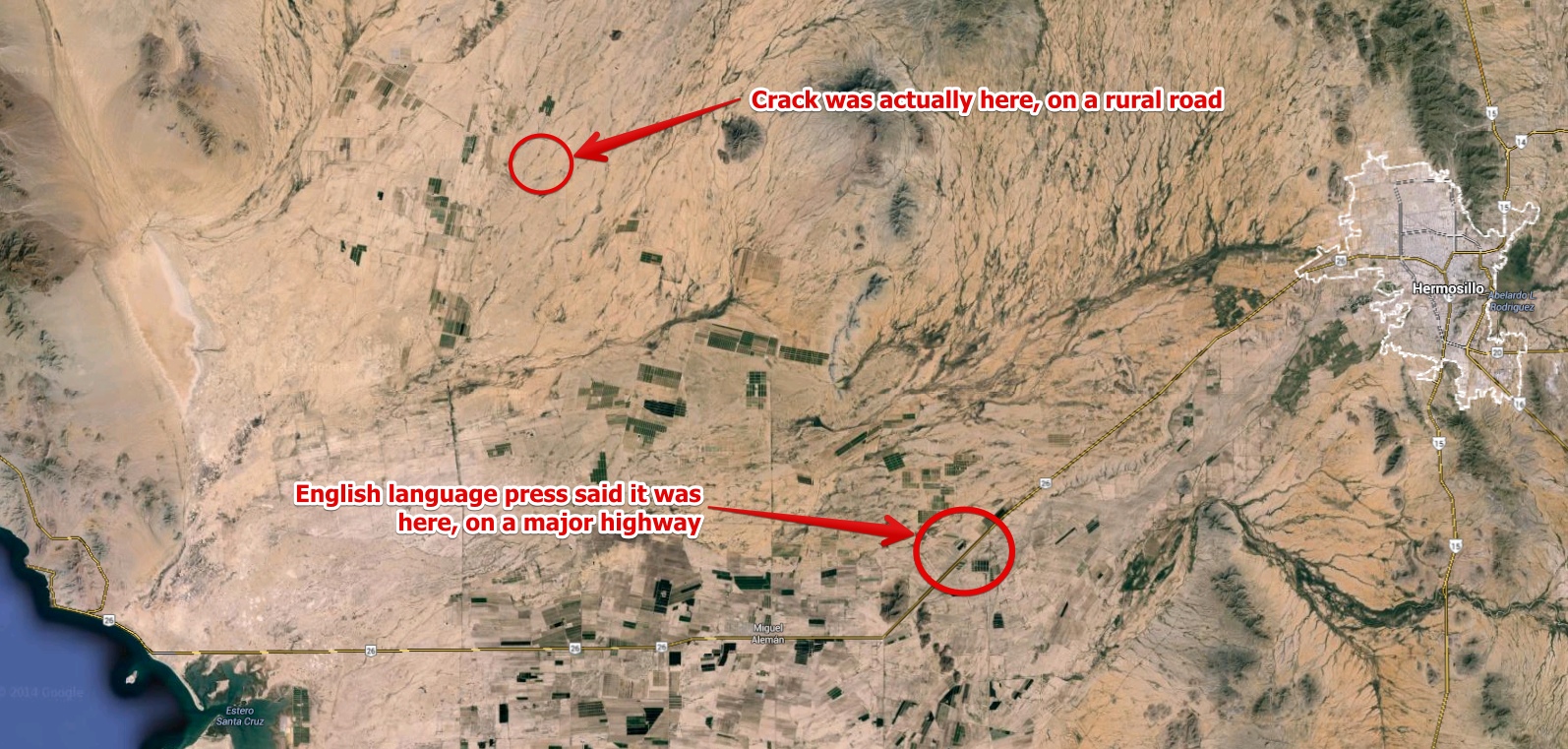
Another misconception in the press is the location of the crack, as typified here:
http://www.news.com.au/technology/e...earthquake-fears/story-e6frflp0-1227032868718
And the Daily Mail:The eight-metre deep trench opened up last week and severed Highway 26 between Hermosillo and the coast in the north of the country.
http://www.dailymail.co.uk/news/art...splits-earth-open-rural-northwest-Mexico.html
Now that would be very significant, as highway 26 is a major route in the region, a paved two lane highway. However, in the image above all we can see is a dirt road. And if we go to the source, we see there's been a bit of a mistranslation somewhere.The crack appeared last week and crosses Highway 26 between Hermosillo, in the northwest of Mexico, and the Gulf of California.
http://www.excelsior.com.mx/nacional/2014/08/21/977513
The problem here is that La Candelaria is a very small town that does not show up on Google maps, so it seem that by a process of Chinese whispers, the road became Hwy 26, and the town became Hermosillo.According to local residents and workers, it was Tuesday night when they discovered the crack running through a rural road that connects Highway 36 North, about 4 kilometers north of Suaqui 'La Candelaria', in the area of the Costa de Hermosillo. [translated from Spanish]
Geolocating photos is an interesting challenge, so I though I'd have a go at this one. Starting with this photo of the crack from the drone footage:
This proved a little tricky, as the fields are new, and don't show up in Google Earth. But I was eventually able to track it down by knowing which road it was on, and by looking at the pattern of brush. In particular there's four small bushes in a line just south of the road, to the right of center. And then on the other side there's four larger bushes in a line leading up to the small mound of rocks.
With this, I was able to find the precise location of the crack.
I've attached a Google Earth .kmz file with this overlay and location.
Attachments
Last edited:
