Debunked: Rivers flow uphill

Rory

Closed Account
In @ericdubay's "200 proofs" list he claims that rivers such as the Nile, the Paraná, the Congo, the Paraguay, and the Mississippi "flow uphill". The rationale behind it seems to be that rivers which flow from north to south (in the northern hemisphere), or south to north (in the southern), and therefore towards the bulge at the equator, will flow into mouths which are further from the centre of the earth than their sources.

For example:

http://www.atlanteanconspiracy.com/2015/08/200-proofs-earth-is-not-spinning-ball.html
External Quote:
4) Rivers run down to sea-level finding the easiest course, North, South, East, West and all other intermediary directions over the Earth at the same time. If Earth were truly a spinning ball then many of these rivers would be impossibly flowing uphill, for example the Mississippi in its 3000 miles would have to ascend 11 miles before reaching the Gulf of Mexico.
As with most (all?) of Dubay's 'proofs', no explanation or evidence is offered, and it appears he is merely quoting from one of the Victorian 'first-wave' flat earth texts. In this case, rather than Rowbotham, he uses 'Terra Firma: The Earth not a Planet', a scripture-inspired book written in 1901 by David Wardlaw Scott.

https://ia800209.us.archive.org/6/items/cu31924031764594/cu31924031764594.pdf
External Quote:
Whoever heard of a river in any part of its course flowing uphill? Yet this it would require to do were the Earth a Globe. Rivers, like the Mississippi, which flow from the North southwards towards the Equator, would need, according to Modern Astronomic theory, to run upwards, as the Earth at the Equator is said to bulge out considerably more, or, in other words, is higher than at any other part. Thus the Mississippi, in its immense course of over 3,000 miles, would have to ascend 11 miles before it reached the Gulf of Mexico!
How he arrives at the figure of 11 miles he doesn't say, though he does reference an 'Imperial Gazetteer' article, so it's possible he took it from this. In any case, I think we can assume that he did a rough calculation that went something along the lines of:

1. Earth's radius is 13.5 miles larger at equator than at poles
2. Length of Mississippi @3000 miles is 48% of the distance from the north pole to the equator (6215 miles)
3. Radius to mouth - radius to source = approximately 48% of 13.5
4. Answer is that the mouth is 6.24 miles 'higher' than the source (after subtracting 1,475 feet for the elevation at source)
5. Write down 11 miles, 'cos reasons.

Now, in actual fact the Mississippi is 2,320 miles long, while its 'as the crow flies' distance between source and mouth is 1,288 miles, and the distance between the lines of latitude at its source and mouth 1,248 miles. Using the above technique, this would make the mouth 2.44 miles 'higher' (further from the centre of the earth) than its source.

That's just a rough figure, of course, but one I would have expected a Victorian flat earth 'scientist' to have arrived at.

And using more modern methods, such as a geoid height calculator, I find a figure of 3.72 miles.

So there you go! The mouth of the Mississippi is not 11 miles higher than its source, it's a little under 4. Which is not an explanation of how this is possible, but another example of how Dubay repeats incorrect information without ever checking it, and yet presents it as fact.

The explanation is a little more straightforward than the laboured 'background check' above:

http://onetuberadio.com/2014/11/07/why-the-mississippi-river-flows-uphill/
External Quote:
The Mississippi River (or any river flowing toward the equator) actually flows uphill. The Earth is not a perfect sphere. There is an equatorial ring about 13.5 miles deep. In other words "sea level" is not constant. It is higher at the equator than it is at the poles.

In the case of the Mississippi the difference is 4.12 miles. The source of the Mississippi, Lake Itasca, is 1400 feet above sea level, and the mouth is, by definition, zero feet above sea level. So we think of all of that water flowing downhill 1400 feet. But it is actually flowing against the force of gravity, going four miles uphill. The force that keeps the water flowing is actually the centrifugal force of the earth's rotation.

If we did measurements of the flow of the water, only the effect of gravity would be observable. But that's only because we're using "sea level" as our reference in the first place. And the difference in sea level is itself caused by that same centrifugal force. So its effect is cancelled out in the measurements that we make.

Counter-intuitively, the gravitational force is much smaller than the centrifugal force. This is demonstrated by the fact that the centrifugal force lifts not only the water, but also the entire crust of the Earth, more than 13 miles at the equator.
Why my calculation was 0.4 miles different to theirs, I'm not sure. But similar enough to debunk the "11 mile" claim. And whatever the figure, the explanation is still the same.

Sorry it was so long: I just like 'taking it back to the source' and uncovering the shoddyness in these "proofs".

Cheers. :)
 
Last edited:
um... huh?

It's a gradual change between the poles and the equator. So 13 miles difference over 6,000 miles

https://en.wikipedia.org/wiki/Equatorial_bulge
External Quote:

An equatorial bulge is a difference between the equatorial and polar diameters of a planet, due to the centripetal force of its rotation. A rotating body tends to form an oblate spheroid rather than a sphere. The Earth has an equatorial bulge of 42.77 km (26.58 mi): that is, its diameter measured across the equatorial plane (12,756.27 km (7,926.38 mi)) is 42.77 km more than that measured between the poles (12,713.56 km (7,899.84 mi)). An observer standing at sea level on either pole, therefore, is 21.36 km closer to Earth's centrepoint than if standing at sea level on the equator. The value of Earth's radius may be approximated by the average of these radii.
 
Although it does not exactly lift the crust of the earth (in the sense that might suggest - lifting the crust alone). It changes the overall shape of the Earth from a sphere to an oblate spheroid.
 
In @ericdubay's "200 proofs" list he claims that rivers such as the Nile, the Paraná, the Congo, the Paraguay, and the Mississippi "flow uphill". The rationale behind it seems to be that rivers which flow from north to south or south to north, and therefore towards the bulge at the equator, will potentially possess mouths which are further from the centre of the earth than their sources.

For example:

http://www.atlanteanconspiracy.com/2015/08/200-proofs-earth-is-not-spinning-ball.html
External Quote:
4) Rivers run down to sea-level finding the easiest course, North, South, East, West and all other intermediary directions over the Earth at the same time. If Earth were truly a spinning ball then many of these rivers would be impossibly flowing uphill, for example the Mississippi in its 3000 miles would have to ascend 11 miles before reaching the Gulf of Mexico.
As with most (all?) of Dubay's 'proofs', no explanation or evidence is offered, and it appears he is merely quoting from one of the Victorian 'first-wave' flat earth texts. In this case, rather than Rowbotham, he uses 'Terra Firma: The Earth not a Planet', a scripture-inspired book written in 1901 by David Wardlaw Scott.

https://ia800209.us.archive.org/6/items/cu31924031764594/cu31924031764594.pdf

Thanks for sorting out the figures here. When I was first caught up in arguing with Dubay's supposed 200 proofs of flatness, this was one of a number that caused me to have to think carefully just to make any sense of what he was claiming. It's an interesting exercise reverse engineering his misconception, isn't it.

I tried to frame the replies with the minimum technicality, not only because of some uncertainty on my part in places, but because debating on YouTube under his video taught me that I was next thing to a Nobel laureate compared to the average level of background knowledge there. Hence I ended up talking about spinning pizza dough to explain the earth's oblateness.

I've included a link to this thread at roundearthsense.blogspot.co.uk. Every little helps, even if the likelihood of most FE believers taking note is small.
 
Last edited:
Although it does not exactly lift the crust of the earth (in the sense that might suggest - lifting the crust alone). It changes the overall shape of the Earth from a sphere to an oblate spheroid.
so.. the answer to why the Mississippi flows toward the equator is "because the Earth is spinning". Which makes the mouth technially 1,475 feet below the source. ?
upload_2016-7-31_14-56-26.png

http://www.esri.com/news/arcuser/0610/nospin.html
 
so.. the answer to why the Mississippi flows toward the equator is "because the Earth is spinning". Which makes the mouth technially 1,475 feet below the source. ?
View attachment 20177
http://www.esri.com/news/arcuser/0610/nospin.html

Yes, or rather, the reason the mouth is further from the earth's centre than the source is because the Earth is spinning.

All that matters is the potential energy. Rivers flow downhill relative to the geoid, ie the surface of the Earth that has an equal potential energy. That potential energy is the result of a combination of the downward force due to gravity and the upward force due to the Earth's rotation ("centrifugal force" in layman's terms).

External Quote:
The geoid is the shape that the surface of the oceans would take under the influence of Earth's gravitation and rotation alone, in the absence of other influences such as winds and tides. This surface is extended through the continents (such as with very narrow hypothetical canals). All points on the geoid have the same gravity potential energy (the sum of gravitational potential energy and centrifugal potential energy). The force of gravity acts everywhere perpendicular to the geoid, meaning that plumb lines point perpendicular and water levels parallel to the geoid.
https://en.m.wikipedia.org/wiki/Geoid
 
The reason the mouth is further from the earth's centre than the source is because the Earth is spinning.
Also, that the Mississippi flows towards the equator is arbitrary, really, purely because its source (highest point above mean sea level) is in the north and its mouth (lowest point amsl) is in the south. A river could just as easily flow from south to north, away from the equator, like the Mackenzie in Canada, or from south to north and south again, crossing the equator twice, such as the Congo in Africa.
 
Last edited:
Also, that the Mississippi flows towards the equator is arbitrary, really, purely because its source (highest point amsl) is in the north and its mouth (lowest point amsl) is in the south. A river could just as easily flow from south to north, away from the equator, like the Mackenzie in Canada, or from south to north and south again, crossing the equator twice, such as the Congo in Africa.
what's amsl? let's remember people, a debunk is only as good as the number of people who can understand it.
 
First, I have to apologize for my poor English!

I have made the account on metabunk in order to see how the "flowing uphill" problem is adressed and I found this thread.

If the Mississippi is flowing towards equator because the earth is spinning that would not be an uniform motion, but an uniform accelerate motion, resulting in a speed of water which is not matched by reality. As any other river the Mississippi speed is greater toward Itasca lake at a similar slope of the riverbed. Only the volume of the water is bigger toward the Gulf of Mexico, which means we need more energy to move the water uphill.

If we take into consideration a certain volume of water, can we calculate a point on the riverbed where the centrifugal force is not enough to move that volume uphill because it became equal with the gravitational force of the volume of water from that point to the Gulf of Mexico?
 
The Mississippi flows towards the equator because the Gulf of Mexico is at a lower altitude than Lake Itasca. At no point does the centripetal force of earths rotation overcome gravity, because if that were the case the planet would simply break apart.
 
If the Mississippi is flowing towards equator because the earth is spinning.
As pointed out above, that's not why the Mississippi flows towards the equator, but rather because its mouth (at sea level) is located to the south of its source (1475 feet amsl). It's actually kind of arbitrary that it flows "towards the equator" - it's simple probability that, of all the rivers in the world, some will flow south (in the northern hemisphere), and some north (in the southern hemisphere), and therefore "towards the equator". But what they all have in common is that they flow from a higher elevation to a lower one (as measured in relation to sea level).
As any other river the Mississippi speed is greater toward Itasca lake at a similar slope of the riverbed.
I'm not really sure what this means. Is the speed you refer to the velocity of the water flow? Why would this be the case? Wouldn't the speed of the water depend on other more localized factors, such as width, depth, tributaries, cascades, snowmelt, etc?
Only the volume of the water is bigger toward the Gulf of Mexico, which means we need more energy to move the water uphill.
Though it's been described as doing so elsewhere, I don't think the river can be said to actually "flow uphill" - it is still flowing 'down', towards the sea - though in one sense I get your point, since it is moving further away from "the centre of gravity". In general, though, we define higher and lower by their relation to sea level, rather than the centre of the earth - which is why Mount Everest is viewed as the highest mountain, rather than Ecuador's Mount Chimborazo.
If we take into consideration a certain volume of water, can we calculate a point on the riverbed where the centrifugal force is not enough to move that volume uphill because it became equal with the gravitational force of the volume of water from that point to the Gulf of Mexico?
As above. And, if you think about the oceans that straddle the equator, it becomes clear that the volume of water isn't really a factor in this.

Good questions, though: it definitely takes a little while to get one's head around it.

PS Your English is fantastic! :)

PPS An interesting question for flat earthers - why did scientists, whose job it is to hide the fact we "don't live on a spinning ball", suddenly decide to describe this "fictional globe" as being an "oblate spheroid", thereby creating a whole bunch of myriad problems which wouldn't be understood by the layman, thereby opening the door to more arguments from incredulity? One would think they'd have been better off just keeping it simple. ;)
 
Last edited:
First, I have to apologize for my poor English!

I have made the account on metabunk in order to see how the "flowing uphill" problem is adressed and I found this thread.

If the Mississippi is flowing towards equator because the earth is spinning that would not be an uniform motion, but an uniform accelerate motion, resulting in a speed of water which is not matched by reality. As any other river the Mississippi speed is greater toward Itasca lake at a similar slope of the riverbed. Only the volume of the water is bigger toward the Gulf of Mexico, which means we need more energy to move the water uphill.

If we take into consideration a certain volume of water, can we calculate a point on the riverbed where the centrifugal force is not enough to move that volume uphill because it became equal with the gravitational force of the volume of water from that point to the Gulf of Mexico?

That is overcomplicating matters, really. On Earth, we measure altitudes relative to mean sea level. And the whole point of that is that the sea finds its own level: namely, it settles to the configuration where it has the lowest potential energy. (Minor fluctuations due to tides and atmospheric pressure patterns aside.)

So effectively you can treat sea level as being a "lowest energy surface" that water will flow down towards. That's what "down" means: travelling from higher potential energy to lower potential energy.

If the globe was a stationary ball of uniform density then sea level would form a perfect sphere, because the only force would be gravity. However, because it rotates, the centripetal centrifugal force (which is highest at the equator) offsets a small fraction of the gravitational force, resulting in sea level bulging outwards a little at the equator. But sea level still represents the lowest energy surface, so anything above sea level is still "uphill" from it.

The distance from the centre of the Earth is irrelevant: what matters is the distance above sea level - or, more precisely, above the "geoid", which is the surface of equal potential energy, taking into account gravity, centrifugal force and variations in density. The source of the Mississippi at Lake Itasca is about 1,500ft above sea level, so clearly the river will flow downwards to the sea.

Trying to separate out the gravitational and centripetal components is not really helpful. All that matters is where you are relative to sea level, because the sea does the work of finding the "lowest energy" shape for you.
 
If the Mississippi is flowing towards equator because the earth is spinning
Rivers go downhill, taking the path of least resistance. The Mississippi just happens to go south. The Rhine in Europe and The Nile in Africa both spend most of their courses going in a Northerly direction towards the North Sea and the Mediterranean respectively. In South America the Amazon and The Orinoco both head East towards the Atlantic, while going back to Africa the Congo flows mainly in a westerly direction, again to Atlantic. Its all down to gravity and the path of least resistance, the spinning of the earth has nothing to do with it.
 
How so? Centripetal force vs force of gravity, no?

Gravity towards earths CoG, centripetal force away from the axis of rotation.

Am I missing something? I guess you could claim it would be more precise to use centripetal and gravitational acceleration?
"The most basic rule of dimensional analysis is that of dimensional homogeneity.[6] Only commensurable quantities (physical quantities having the same dimension) may be compared, equated, added, or subtracted. "
https://en.wikipedia.org/wiki/Dimensional_analysis
I am not bothered by centripetal v centrifugal, or whether you compare forces or accelerations.
 
The St. Johns River, in Florida, flows from south to north. The elevation drop is about 30 ft from headwaters to mouth. If the spinning of the earth had anything to do with, you'd think that it would impact a "lazy" river like the St. Johns. But it doesn't.
 
"The most basic rule of dimensional analysis is that of dimensional homogeneity.[6] Only commensurable quantities (physical quantities having the same dimension) may be compared, equated, added, or subtracted. "
https://en.wikipedia.org/wiki/Dimensional_analysis
I am not bothered by centripetal v centrifugal, or whether you compare forces or accelerations.
You are being a bit pedantic there. We know F = ma, and we know things don't fly off into space. So for any given object the force due to gravity is more than the effective force due to the earth spinning. We don't need more for the purposes of this thread.
 
The St. Johns River, in Florida, flows from south to north. The elevation drop is about 30 ft from headwaters to mouth. If the spinning of the earth had anything to do with, you'd think that it would impact a "lazy" river like the St. Johns. But it doesn't.

The point isn't that the centrifugal forces cause all rivers to go southwards, but rather that the Earth's rotation helps set the line of sea level where total gravitational potential is zero.
 
The St. Johns River, in Florida, flows from south to north. The elevation drop is about 30 ft from headwaters to mouth. If the spinning of the earth had anything to do with it, you'd think that it would impact a "lazy" river like the St. Johns. But it doesn't.
I'm not 100% sure what you mean with this. Can you explain a little further please?
 
The point isn't that the centrifugal forces cause all rivers to go southwards, but rather that the Earth's rotation helps set the line of sea level where total gravitational potential is zero.

So the TGP=0 line is to the south if you're in the South Florida, but to the north if you're in Central or North Florida? How why isn't simple elevation/geography/gravity a better explanation? Why does the St. Johns flow north, but many of the other rivers in the Jacksonville area flow in other directions? Rivers flow towards it, because water flows downhill. Even as an ovoid, sea level is sea level. The direction that rivers flow is based upon height above sea level and hard rocks.
 
So the TGP=0 line is to the south if you're in the South Florida, but to the north if you're in Central or North Florida? How why isn't simple elevation/geography/gravity a better explanation? Why does the St. Johns flow north, but many of the other rivers in the Jacksonville area flow in other directions? Rivers flow towards it, because water flows downhill. Even as an ovoid, sea level is sea level. The direction that rivers flow is based upon height above sea level and hard rocks.
I'm not really sure what you mean by "the TGP=0 line" but, basically, the rivers in Florida, like everywhere in the world, are following routes from higher elevations to lower elevations, eventually reaching sea level. The compass direction they flow in is arbitrary - it could be any direction, and it could change between all directions many times over its course (like the Congo). A river's direction is dictated by terrain.
 
I'm not 100% sure what you mean with this. Can you explain a little further please?
Hey Rory! Sorry, will try to elaborate -- The St. Johns flows from topography (high to low). Given that the elevation change is very small given the length of the watershed/river, basic physics would indicate that any outside influence (other than simple gravity) would have a noticeable influence on the flow and direction of the river. Having lived here for more than 30 yrs, I can attest that the St. Johns flows south to north. The St. Johns river flows downhill, regardless of the compass direction.
 
I'm not really sure what you mean by "the TGP=0 line" but, basically, the rivers in Florida, like everywhere in the world, are following routes from higher elevations to lower elevations, eventually reaching sea level. The compass direction they flow in is arbitrary - it could be any direction, and it could change between all directions many times over its course (like the Congo). A river's direction is dictated by terrain.
We're in adamant agreement! Apologize for any misunderstanding, was trying to support the debunk position.
 
We're in adamant agreement! Apologize for any misunderstanding, was trying to support the debunk position.
Yup. I was just re-reading and was like, hold on, I'm just saying exactly what he just said - duh, he knows full well why rivers flow in the direction that they do. ;)
The point isn't that the centrifugal forces cause all rivers to go southwards, but rather that the Earth's rotation helps set the line of sea level where total gravitational potential is zero.
Or, to put it another way, the rotation of the earth generates centrifugal force, which causes the earth to be an oblate spheroid rather than a perfect sphere. This means sea level is not always the same distance from the centre of the earth, but neither the rotation nor the shape of the planet have any bearing on which directions rivers flow in: that is solely subject to changes in elevation (above sea level) and topography.

Would that be an accurate paraphrase?
 
Rory, no sweat. I had to dredge up my high school physics after Irma, as had to drain down pool with no power (for four days). Set up a garden hose siphon, and viola! Overnight, drained 4 inches of water from pool to (lower elevation) backyard. No harm, no foul, just communicating! :-)
 
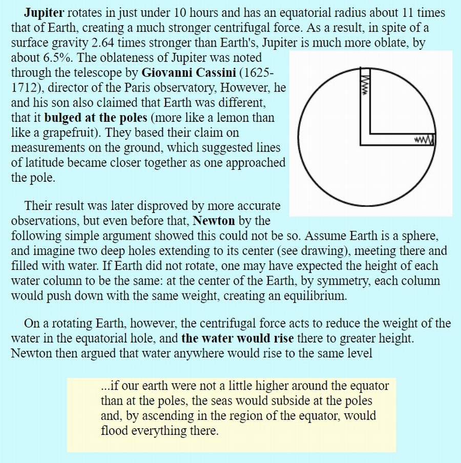
This thought experiment by Isaac Newton should clarify...
http://www.phy6.org/stargaze/Srotfram1.htm
External Quote:

1607fb9a027c80cc4de8efc340ff376a.jpg
If the earth stopped spinning, (but somehow maintained its oblate shape!), the Mississippi would not flow south, and the oceans would pile up in the northern and southern hemispheres.

If the earth did rotate, but somehow was a perfect sphere and did not have an equatorial bulge, the seas would pile up around the equator and leave the northern and southern poles dry. As Newton argued.

But neither situation is possible, because land and sea are both matter and are affected in identical ways by gravity and "centrifugal force."

The simplest, intuitive way to understand this is: "Centrifugal force" creates the earth's bulge -AND- this same exact "force" also helps water flow that same distance farther away from the center of the earth's mass. It's the same force and it has the same effect on land and sea. That's natural, isn't it?
 
Last edited:
If the earth stopped spinning [...] the oceans would pile up in the northern and southern hemispheres.
I wonder where exactly?

And - wow - I didn't know Jupiter's equitorial rotation is about 28,000mph. That's fast! :)
 
Good ask, because I can point to an article that explores exactly that.
https://www.esri.com/news/arcuser/0610/nospin.html

Edit: The same one that was cited earlier in this thread, btw...


The "Northern Circumpolar Ocean"
ca66bc57e739347680add4f7e3a52988.jpg


External Quote:
Today, all three world oceans are connected. This creates a global ocean with basically one sea level. As a consequence of rotational slowdown, the outline of the global ocean would continuously undergo dramatic changes. Equatorial waters would move toward polar areas, initially causing a significant reduction in depth while filling the polar basins that have much less capacity. As regions at high latitude in the northern hemisphere become submerged, the areal extent of the northern circumpolar ocean would rapidly expand, covering the vast lowlands of Siberia and northern portions of North America. The global ocean would remain one unit until the rotation of the earth decreased to the speed at which ocean separation would occur. The interaction between the inertia of huge water bodies and decreasing centrifugal force would be very complicated. As the consequence of steady slowdown of earth's rotation, the global ocean would be gradually separated into two oceans. Obviously, the last connection will be broken at the lowest point of the global divide line, located southwest of the Kiribati Islands. Since the current western Pacific Ocean is a plane, land would emerge quickly because there would be no chance that water would be exchanged between the two circumpolar oceans after the initial split. The area of final separation between the two oceans would be the simultaneous emerging and drying of territory extending for hundreds of kilometers.

External Quote:
...during the Devonian period (400 million years ago), the earth rotated about 40 more times during one revolution around the sun than it does now. Because the continents have drifted significantly since that time, it is difficult to make estimates of the land versus ocean outlines for that era. However, we can be certain that—with a faster spinning speed in the past—the equatorial bulge of oceanic water was much larger then than it is today. Similarly, the ellipsoidal flattening of the earth was also more significant.
That last is important because one mustn't imagine that the earth's current equatorial bulge is a legacy of an earlier time when the earth rotated faster. It wasn't solidified or frozen into the earth. It's a dynamic system. The present equatorial bulge is a result of the current speed of the earth's rotation.
 
Last edited:
Edited a bit to correct some things and add one more flavor.

There are different flavors of the FE belief in rivers flowing the wrong way.

1. The most common: FE believers have a naive intuitive belief that south is "down" and north is "up" simply because maps and globes traditionally are made to be displayed that way. It goes back to the immutable direction of "down." In this case it's not the Mississippi that outrages them. It's the Nile. The Nile flows "up." To them the sphere earth is an impossible figure to live on, with most of it either a vertical surface or upside down.

2. Another common one: The earth curves such and such miles along the course of the river; therefore the river would have to climb (or fall) such and such miles. Confusing curve with gain or loss in elevation.

3. The more savvy argument is a legacy from Victorian Edwardian times when Rowbotham David Wardlaw Scott produced more skilled sophistries. And it's exactly that argument you presented in the OP. That water would have to "climb" the "slope" of the equatorial bulge, away from the center of the earth and fighting gravity.

Although this antique FE argument is presented, only a minority of current day FE believers actually understand it on any level. When these same are presented with the argument that water is helped up the bulge by centrifugal force they become outraged at the silly ad hoc nature of this. It would be a bizarrely unlikely coincidence that centrifugal force would give water just the exact amount of force to "climb" the "slope" of the bulge - no more, no less. This is because they don't link the bulge itself to that same centrifugal force. They seem to think it's just an arbitrary lump or what-not.

Rowbotham David Wardlaw Scott had no excuse to make this argument, as Isaac Newton had explained all this long before he was born.
 
Last edited:
The point isn't that the centrifugal forces cause all rivers to go southwards, but rather that the Earth's rotation helps set the line of sea level where total gravitational potential is zero.

You shouldn't speak in terms of simply gravitational potential energy. Not taking everything into account. Trailbalzer said it best.

If the globe was a stationary ball of uniform density then sea level would form a perfect sphere, because the only force would be gravity. However, because it rotates, the centripetal centrifugal force (which is highest at the equator) offsets a small fraction of the gravitational force, resulting in sea level bulging outwards a little at the equator. But sea level still represents the lowest energy surface, so anything above sea level is still "uphill" from it.

The distance from the centre of the Earth is irrelevant: what matters is the distance above sea level - or, more precisely, above the "geoid", which is the surface of equal potential energy, taking into account gravity, centrifugal force and variations in density.
 
The Mississippi flows towards the equator because the Gulf of Mexico is at a lower altitude than Lake Itasca. At no point does the centripetal force of earths rotation overcome gravity, because if that were the case the planet would simply break apart.

Agreed with you, but the altitude from wikipedia.org is 450 meters and the difference r1-r2, where r1 is Earth radii at the Gulf of Mexico latitude and r2 is Earth radii at the Itasca lake latitude is more than six thousands meters if you use WGS84 and very similar if you use an other geodedic system. As nobody sees a river flowing uphill, looks like we have to replace our geodedic systems.
 
Agreed with you, but the altitude from wikipedia.org is 450 meters and the difference r1-r2, where r1 is Earth radii at the Gulf of Mexico latitude and r2 is Earth radii at the Itasca lake latitude is more than six thousands meters if you use WGS84 and very similar if you use an other geodedic system. As nobody sees a river flowing uphill, looks like we have to replace our geodedic systems.
Sounds about right: in the OP it's stated that I calculated the difference at 3.72 miles, while the article I quoted had it at 4.12 miles.

Still nothing wrong with either the geodetic system or the idea that rivers can end further from the centre of the earth than they begin though. :)

PS I do hope we're not losing track of what this thread's actually about, what with all this interesting discussion of rotation, centrifugal force, and oblate spheroids - namely, that Eric Dubay can't be relied upon to perform even the most basic level of research on his "proofs". ;)
 
Last edited:
For Rory: The spinning of Earth reason regarding the Mississippi was taken from this thread, maybe it was my poor understanding... anyway, you said that the Mississippi mouth beeing 1475 feet below its source is the reason and I cannot but agreed. Now we have two possibilities: in the first case the altitude is included in r2, where r2 is the Earth radii at the source of Mississippi latitude, in the second case the altitude of the Itasca lake is not included in r2.

If you calculate r1, the Earth radii at the Mississippi mouth latitude, you will have a diference r2-r1 in excess of six thousand meters in case you are going to use WGS84, which renders irrelevant which of the above cases you wish to consider. That was the reason for which I wrote in my answer to Spectrar Ghost that we have to change our geodedic systems.
I understand the calculation - I did it myself in the OP - but what I'm curious about is what you think is wrong with the source of the Mississippi being around 6000 metres further from the centre of the earth than its mouth?
 
That is overcomplicating matters, really. On Earth, we measure altitudes relative to mean sea level. And the whole point of that is that the sea finds its own level: namely, it settles to the configuration where it has the lowest potential energy. (Minor fluctuations due to tides and atmospheric pressure patterns aside.)

So effectively you can treat sea level as being a "lowest energy surface" that water will flow down towards. That's what "down" means: travelling from higher potential energy to lower potential energy.

If the globe was a stationary ball of uniform density then sea level would form a perfect sphere, because the only force would be gravity. However, because it rotates, the centripetal centrifugal force (which is highest at the equator) offsets a small fraction of the gravitational force, resulting in sea level bulging outwards a little at the equator. But sea level still represents the lowest energy surface, so anything above sea level is still "uphill" from it.

The distance from the centre of the Earth is irrelevant: what matters is the distance above sea level - or, more precisely, above the "geoid", which is the surface of equal potential energy, taking into account gravity, centrifugal force and variations in density. The source of the Mississippi at Lake Itasca is about 1,500ft above sea level, so clearly the river will flow downwards to the sea.

Trying to separate out the gravitational and centripetal components is not really helpful. All that matters is where you are relative to sea level, because the sea does the work of finding the "lowest energy" shape for you.

The distance from the center of the Earth cannot be irrelevant because the ocean cannot be below its own floor, which floor is included in r1, where r1 is the Earth radii at the mouth of Mississippi latitude. The "lowest energy surface" about which you wrote is above ocean floor and ocean floor is above Itasca lake in our geodedic systems, including WGS84. I do not have enough altitude at the r2, where r2 is the Earth radii at the Itasca lake latitude, in order to make r1-r2 difference a negative number.
 
The distance from the center of the Earth cannot be irrelevant because the ocean cannot be below its own floor, which floor is included in r1, where r1 is the Earth radii at the mouth of Mississippi latitude. The "lowest energy surface" about which you wrote is above ocean floor and ocean floor is above Itasca lake in our geodedic systems, including WGS84. I do not have enough altitude at the r2, where r2 is the Earth radii at the Itasca lake latitude, in order to make r1-r2 difference a negative number.
I think you're overcomplicating matters. All relevant explanations are in the thread already, so maybe having another read through may clear things up.

Also, I'm not really sure why you think "ocean floor" would be relevant - unless you mean "ocean surface" (i.e., "sea level").

PS I fully agree with you that the ocean cannot be below its own floor.
 
Back
Top