Debunked: Look-up.org.uk's claims of aerial spraying over London on April 12 2015

Trailblazer

Moderator
Staff member
The latest claim from Ian Simpson (Look-up.org.uk) is that on April 12 this year London was hit by "the most obvious aerial spraying this year": http://www.look-up.org.uk/obvious-aerial-spraying-london-year/

upload_2015-4-23_14-21-3.png


upload_2015-4-23_14-1-16.png

Taking his claims one at a time:

[bunk]As the natural weather improves, pressure goes up and moisture levels drop it seems that the trails are starting to be more visible. Many online commented that this level of activity is unusual. Sadly not, and we often see this frequency of aircraft crossing London leaving persistent trails. There were, however, 2 important differences on Sunday 12th.

1. The air was dry and so there was no induced-cumulus to hide the trails.[/bunk]

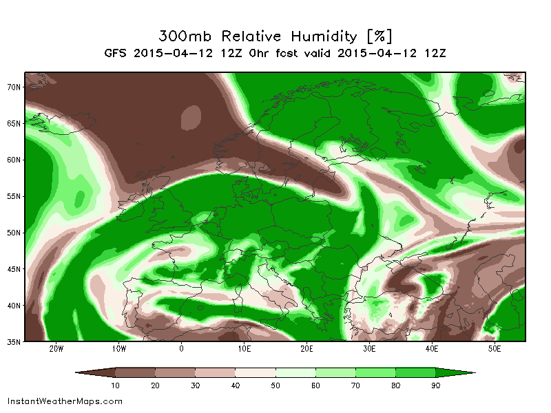
No, the air at flight levels was pretty well saturated with moisture over the whole of England. This is the chart for 1pm BST on Sunday April 12th, as shown by the following chart for 1pm BST on that day. This is the zero hour (i.e. real time) forecast from the GFS global weather model, run by the US NCEP.


[bunk]2. unusually none of the aircraft we saw spraying were listed on Flightradar24.com. We have screenshots to prove that all of these aircraft were flying over London and not broadcasting any flight data. We believe this is contrary to flight regulations and will be speaking to the CAA about this.[/bunk]

Note that no screenshots were posted. I was not far from London on Sunday and noticed a lot of contrail activity (not as much as over London itself, judging by those photos), and every plane I bothered to check showed up on FR24 just fine.

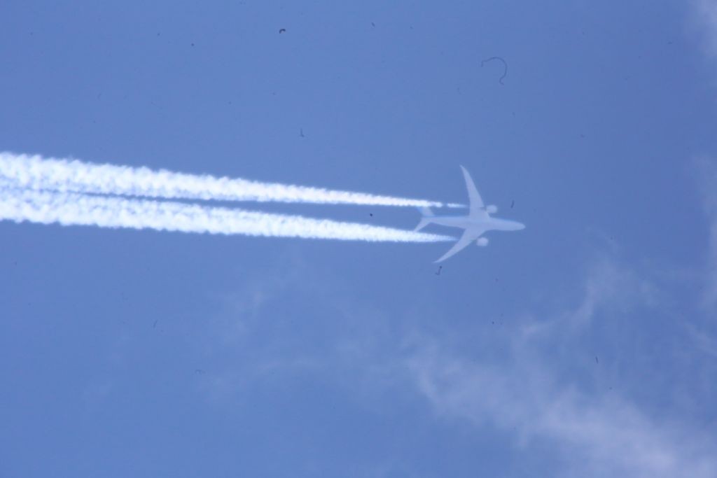
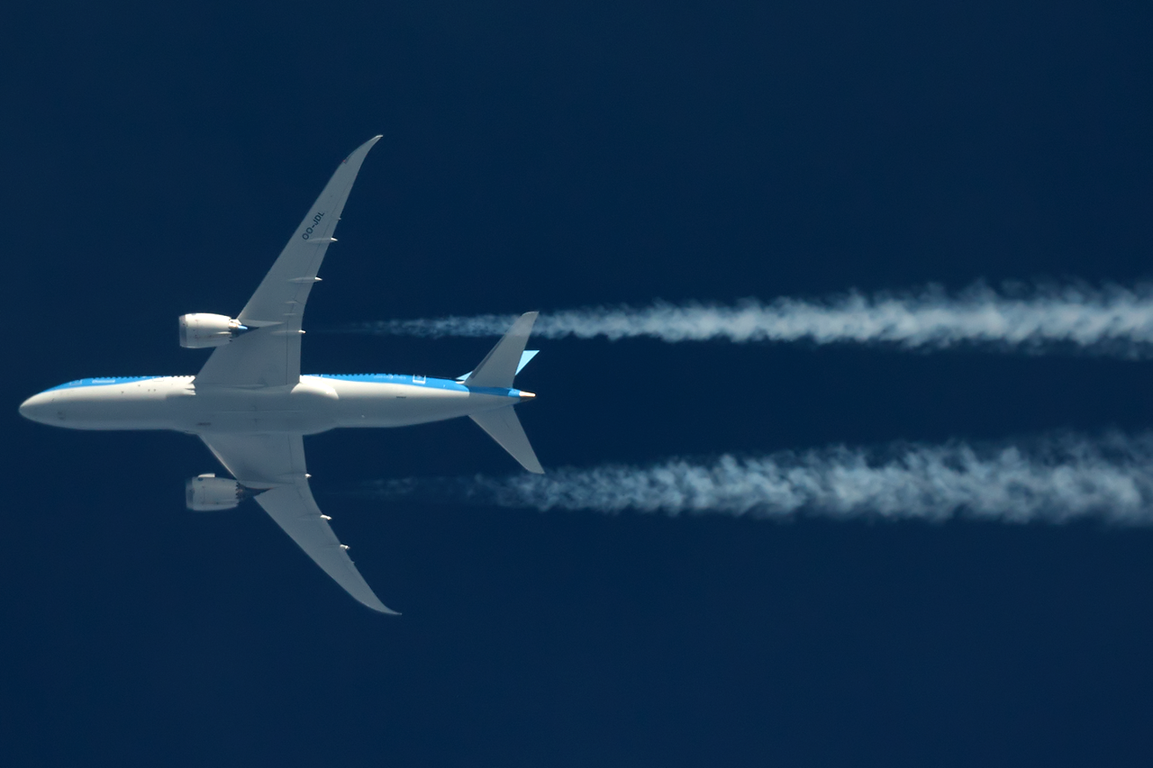
This plane he has several photos of appears to be in KLM livery:

upload_2015-4-23_15-21-43.png

And KLM doesn't even have any "A320 family aircraft" in its fleet: http://www.planespotters.net/Airline/KLM-Royal-Dutch-Airlines

upload_2015-4-23_14-6-27.png

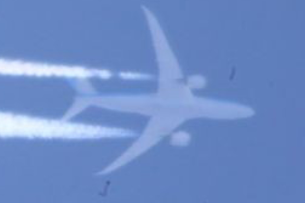
The aircraft actually appears to be a Boeing 777. Here's a photo of a KLM Boeing 777 for comparison:


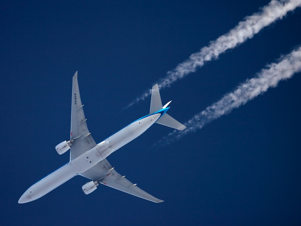
Comparing to Ian's photo, you can see the pale and dark blue stripe pattern on the tail in both:

upload_2015-4-23_15-22-18.png

There's no time or location info on Ian's pictures, other than "London, 12 April", but looking at the lighting, the sun was to the right of the plane. If the photo was taken somewhere near the middle of the day, that suggests the plane was flying roughly eastwards, and to the north of the camera.

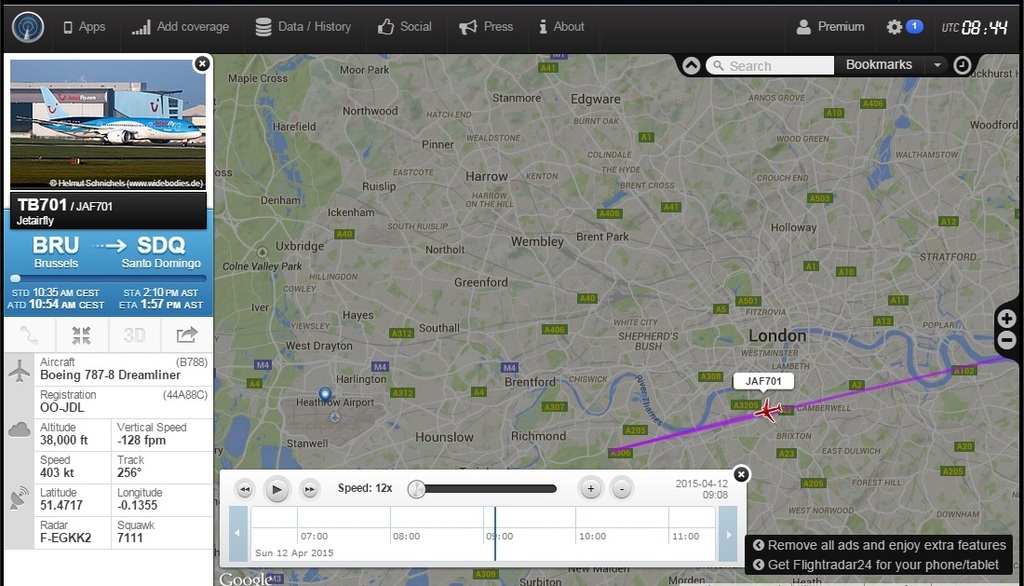
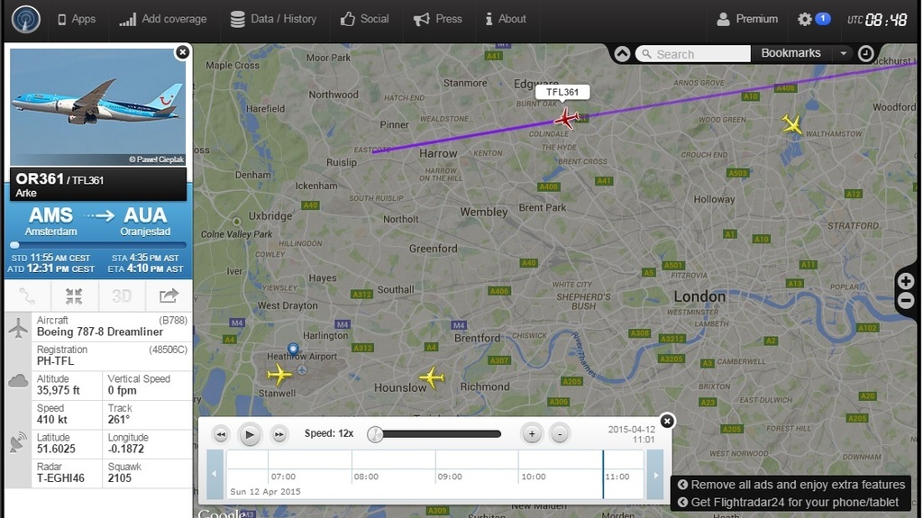
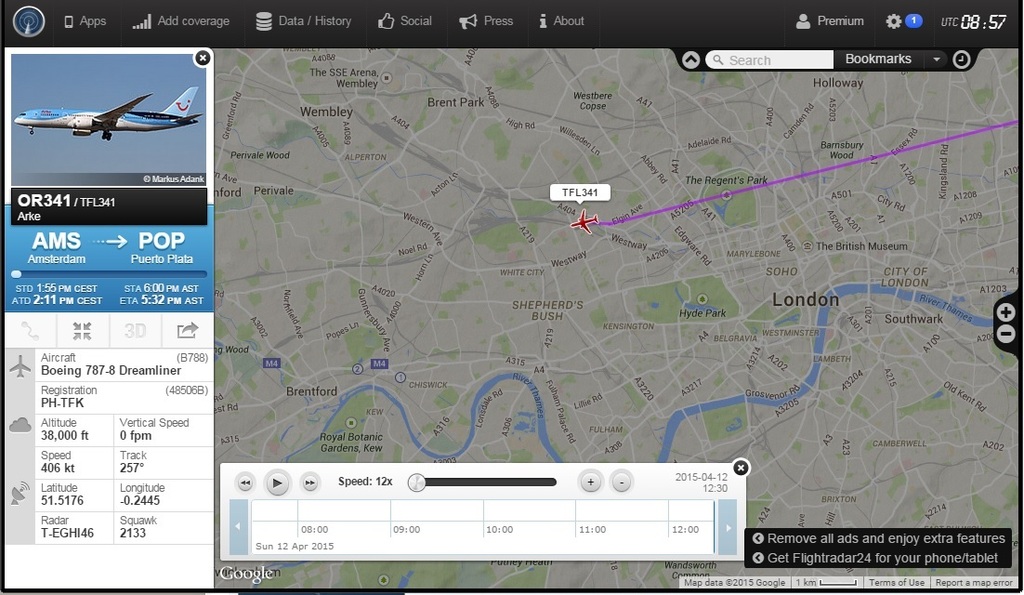
A quick look on FlightRadar24 reveals a succession of long-haul KLM 777s flying into Amsterdam from Central and South America, heading roughly eastwards just to the north of London during the morning of April 12. Depending on the exact location of the photos, any of these could be potential candidates.

10:09 BST
upload_2015-4-14_13-47-46.png

10:16 BST:
upload_2015-4-14_13-49-34.png

10:26 BST:
upload_2015-4-14_13-50-46.png

11:18 BST:
upload_2015-4-14_13-52-32.png


[bunk]It is important to note that many of these aircraft are being routed deliberately out of their direct route to their destination so they pass over London.[/bunk]

If the planes are not broadcasting any flight data, then how does Ian claim to know what their direct route should be? :)

Here is a screenshot from skyvector.com showing the main air routes over England. London is circled, as is Amsterdam.

upload_2015-4-23_14-18-17.png

Clearly, routes from Amsterdam to and from Central and South America will pass over London as a matter of course, as will huge numbers of other flights between American and European/Middle Eastern destinations. I live about 35 miles southwest of London, and witness high volumes of such east-west traffic passing overhead.
 
Last edited:
This is a satellite view of the UK on the day in question. It shows clear skies in the southeast corner, with an extensive sheet of cloud across the middle of the country, and a colder, drier airmass with convective cumulus clouds to the north:

upload_2015-4-23_14-25-48.png

At the time this image was taken, there doesn't seem to be much contrail activity over London itself, but there are several well-developed trails a little further south:

upload_2015-4-23_14-26-48.png

Notice how the direction of these trails agrees well with the map of air routes above.
 
Clearly, routes from Amsterdam to and from Central and South America will pass over London as a matter of course, as will huge numbers of other flights between American and European/Middle Eastern destinations. I live about 35 miles southwest of London, and witness high volumes of such east-west traffic passing overhead.

April 12, 2015 was indeed a great contrail day for those who live in the South of England, especially at the crossings of major air traffic routes. There are plenty of photos of contrail grids and other patterns taken on that day. Here, for example, is a couple of pictures from the Heathrow airport area:


However, most popular pattern was spotted in the Gatwick airport area south of London. I found a dozen of pictures of three trails crossing each other at the same point. Here are just three of them:


They depict the same contrail pattern from different directions, yet, at the first glance, the pattern look the same. However, the fine details and the remnants of a short trail in one of the sectors, show "rotation" of the contrail positions.

EDIT
It appears that after some upgrade of the flickr site, the embedded here images look smaller:(
 
Last edited:
However, most popular pattern was spotted in the Gatwick airport area south of London. I found a dozen of pictures of three trails crossing each other at the same point. Here are just three of them:


They depict the same contrail pattern from different directions, yet, at the first glance, the pattern look the same. However, the fine details and the remnants of a short trail in one of the sectors, show "rotation" of the contrail positions.

EDIT
It appears that after recent upgrade of the flickr site, the embedded here images look smaller:(


Two of those have EXIF data, showing times of 9:49 and 10:45am. I doubt such a pattern would persist for an hour, so I assume it's a GMT/BST issue and the actual time was around 10:45am BST (9:45am UTC). Does anyone here have premium access to FR24, which gives 30 days of playback?
 
Two of those have EXIF data, showing times of 9:49 and 10:45am. I doubt such a pattern would persist for an hour, so I assume it's a GMT/BST issue and the actual time was aorund 10:45am BST (9:45am UTC). Does anyone here have premium access to FR24, which gives 30 days of playback?
Well, when I saw the photos of the three crossing contrails first, FR24 playback for April 12 was still available. I toyed with the idea to identify these flights for a while, but then decided it would be too much effort for too little certainty. It is not about finding the three flightpaths that cross in the same point. It is about finding the three flight tracks (with timing) and the unknown direction and speed of the wind that would bring three contrails to cross in the same point.
It was doable, but it would take a lot of time. I did a similar exercise for the sunrise contrails in London on November 24, 2014 but it took so long that I left it unpublished. I still have all data in a KMZ file. Here is a gallery of selected photos of these contrails:
A Study in Scarlet .jpg
 
Great pictures. I know you wouldn't want to see this sky every day but it's pretty beautiful in its own way, sad that Ian can't enjoy it.
 
Great pictures. I know you wouldn't want to see this sky every day but it's pretty beautiful in its own way, sad that Ian can't enjoy it.
You wouldn't see it every day, such good conditions for persistent contrail formation do not happen very often, at least in the UK. In the following photostream, there is a collection of daily images of the sky near Birmingham taken over several years, illustrating how the British skies usually look like:
INFORMATION by Birmingham Selly Oak Weather, on Flickr

John Clayton
In the past BSOWS has published daily weather reports and images on Flickr but as from 1st December rather than publishing routinely BSOWS will only be publishing images and reports relating to significant weather events. This new approach is trialled in the next two images and reports.
Content from External Source
 
I was staying with family on the weekend in question so was further from London than usual. There was fairly heavy contrail activity but nothing too out of the ordinary. Here are a couple of photos from April 12 near Stockbridge, Hampshire. So it certainly wasn't like that across the whole country, or even the whole southeast.

image.jpg image.jpg
 
April 12 near Stockbridge, Hampshire. So it certainly wasn't like that across the whole country, or even the whole southeast.

Actually, it was from my part of South East Dorset (looking East, West and South), I just didn't get out of my pit early enough (to setup timelapse and capture it) and by mid-morning most of it had dissipated but I can assure you it was heavy for a while.
 
Actually, it was from my part of South East Dorset (looking East), I just didn't get out of my pit early enough (to setup timelapse and capture it) and by mid-morning most of it had dissipated but I can assure you it was heavy for a while.
Must have missed it then!

Of course, if you believe people like Ian, it should inevitably have led to a "whiteout", but as my pictures show, the rest of the day was largely sunny.

(Just checked the EXIF data and those photos were at 2:31pm and 2:07pm respectively. I don't remember seeing any dramatic contrails in the morning but maybe I wasn't "looking up" ;) )
 
I just recall rising from my pit and looking out the window (East facing IIRC 6:30am-ish) and seeing persisting trails as I've never seen before. Shame they didn't persist longer than a few hours but being a shill, I was obviously "protected" and enjoyed a glorious horizon-horizon deep blue sunny sky for the rest of the day. :p
 
Last edited:
Actually, it was from my part of South East Dorset (looking East, West and South), I just didn't get out of my pit early enough (to setup timelapse and capture it) and by mid-morning most of it had dissipated but I can assure you it was heavy for a while.
I did set up my iPhone for timelapse that morning, but did not notice it was short on memory and ended up with a 30 second movie (less than hour of real time). I do not have a youtube channel, so I attach an mp4 file. Here is a frame from it. The camera was facing south, toward London. The contrail grid in the bottom left corner is to the east of the capital:
Screen shot 2015-04-25 at 11.20.49.png
It matches the grid on this flickr photo from London:
 

Attachments

  • 20150412_TL.mp4
    4.3 MB · Views: 871
Last edited:

Ian (hello Ian!) claims it wasn't his doing https://www.facebook.com/permalink.php?story_fbid=1628786497352086&id=1410029482561123
Oh yes you know you are pissing them off when they clone your account. If you see a picture of me with a roll=up in my mouth, that is not my account so please ban and better still report for harassment....
Content from External Source
ETA: It's probably my gaff but I'm sure I linked (post: 150673) a different facebook post to the one it's showing now. Ok, it's the same link but the new account (and it's post) have dissappeared, that's what threw me.
 
Last edited:
Meaning they cloned his "Look up" site?

No, a new "Ian Simpson" page. But I can't locate it now, presume he got it taken down.

From another of his pages https://www.facebook.com/look.up.96387/posts/1579842072254983
I have had my account cloned and am being attacked by trolls that i have banned several times, so i think we can safely say that Fakebook is not doing it's job properly or is ignoring it's own rules and allowing those people to continue to post.
Content from External Source
 
So is he targeting all Ian Simpsons on face book? and trying to get them taken down?

Hope not, I know two other Ian Simpsons on faceache, ones a very old friend and another is a mate from my local music scene, neither are CT minded. Maybe I should give them a heads up just in case?
 
So is he targeting all Ian Simpsons on face book? and trying to get them taken down?

Hope not, I know two other Ian Simpsons on faceache, ones a very old friend and another is a mate from my local music scene, neither are CT minded. Maybe I should give them a heads up just in case?

Not that I know of. This particular page had used Ian's own photos (for his profile pic - using the one with him smoking a spliff and edited with "chemtrails" pointed at the smoke) and then "trolling" Ian's Look-up account with science.
 
Two of those have EXIF data, showing times of 9:49 and 10:45am. I doubt such a pattern would persist for an hour, so I assume it's a GMT/BST issue and the actual time was around 10:45am BST (9:45am UTC). Does anyone here have premium access to FR24, which gives 30 days of playback?
I found yesterday that planefinder.net gives more days of playback. I have not checked yet how far back it goes, but I was able to get April 6 data I was looking for. I also looked into April 12 again to figure out which flights might have produced the three contrails crossing in the same point.
This new photo, taken in Horsham at 10:52 BST (9:52 UTC) looking East, gives a reference point:

A nearly vertical trail in this photo suggests that one of the planes was heading East. Surprisingly, there were not many planes flying over that particular area at contrail altitudes around that time. The tentative candidates are:
Flight Callsign Tail Altitude Heading
FR9388 RYR308F EI-DWK 37,000 ft 157° passed ~20 km (12 miles) West of Horsham at about 9:18 UTC
DK2438 VKG2438 OY-TCG 36,000 ft 30° Passed over Horsham at about 9:29 UTC
LH465 DLH465 D-ABVR 37,000 ft 82° Passed over Horsham at about 9:40 UTC

With the forecasted Westerly (260°) wind on the date and time, the first crossing would have happened over Horsham and the second one to the East of the town, as seen in the above photo.
 
Last edited:
Surprisingly, there were not many planes flying over that particular area at contrail altitudes around that time. The tentative candidates are:
Flight Callsign Tail Altitude Heading
FR9388 RYR308F EI-DWK 37,000 ft 157° passed ~20 km (12 miles) West of Horsham at about 9:18 UTC
DK2438 VKG2438 OY-TCG 36,000 ft 30° Passed over Horsham at about 9:29 UTC
LH465 DLH465 D-ABVR 37,000 ft 82° Passed over Horsham at about 9:40 UTC

With the forecasted Westerly (260°) wind on the date and time, the first crossing would have happened over Horsham and the second one to the East of the town, as seen in the above photo.
It looks like the candidate flights fit the bill nicely. The LH465 heading coincides with the forecasted wind direction, which simplifies the analysis. The LH465 contrail probably did not move laterally and the triple crossing point was moved by the wind along the LH465 track (red). RYR308F (solid blue track) crossed it at point A at 9:18 UTC. In 11 minutes the 'crossing' point on the RYR308F contrail was moved 20 km to the East, to point B, where VKG2438 (solid green track) crossed the LH465 track at 9:29 UTC. This gives the wind speed of about 110 km/h, which is almost the same as the forecasted value of 112 km/h. About 12 minutes later, LH465, following its route (red track) met with the crossing point of two contrails in point C at 9:41 UTC. The triple crossing point continued its move along the red track, its position at any given time can be deduced using the estimated speed. For example, it would reach point D at 9:54 UTC (RYR308F and VKG2438 trails are modelled with dashed lines).
triple crossing 12-04-2015.png
The yellow ovals mark approximate locations of the four photos of criss-crossing trails in the above posts (#5 and #21). To verify the calculated location(s) of the trails, I've looked for photos from other possible locations where they could have been seen. Here is one of such photos from Brighton (purple oval):

As the three crossing trails were carried by wind further through Kent, they were joined by more trails. Here are their photos from two different sides, one from a location just north of Brighton looking East:

the other is from London looking South southeast:
 
Last edited:
Back
Top