Stevan Gvozdenovic
Member
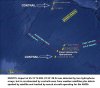
the known satellite dataMH370 contrails have been identified and measured by Kirill Prostyakov and Bobby Ulich
• High-resolution long-wave infrared imagery was used to detect nighttime contrails and to
trace the path of 9M-MRO during the final maneuvers from 18:22 – 18:40 UTC on 7 March
2014
– 3 Turns were made between 18:22 and 18:37
– A climb to higher altitude (~FL390) also probably occurred from ~18:25 to just before 18:28 (based on contrail path
– The first turn (~60 deg left) occurs immediately after reaching the last radar contact position and is toward Banda
– The second turn (~80 deg right) is toward waypoint SAMAK
– The third and final turn (~110 deg left) is directly to waypoint IGEBO
• Additional infrared and visible images also showed the aircraft track during its southward
journey into the SIO
• Detection of a contrail extending from 31S to 38S provides an estimated 7th arc crossing at
approximately (39.9S,84.5E)
• Preliminary route fitting based on BTOs and steady Mach 0.84 speed indicates a great circle
route through IGEBO passes within a few miles of the contrail locations
– Equivalent Still Air Distance traveled from 17:07 to 00:16 is 3,541 NM and indicates an average engine PDA of 2.4%
– RMS variation in TAS from Mach 0.840 is < 1 knot from 18:22 to 00:11 after compensation for wind and temperature
– Approximate BTO and BFO values calculated using the contrail maneuvers (plus a climb) appear to be consistent with
• A preliminary estimate of the 7th Arc crossing based on the computer route fit through IGEBO
is (39.63S,85.00E)
and BFO data)
Aceh (WITT) or possibly Maimun Saleh (WITN)
https://drive.google.com/file/d/0BzOIIFNlx2aUWEtvSjBVS2JWX0E/view
Attachments
Last edited by a moderator: