
Z.W. Wolf
Senior Member.
For some reason few people on both sides of the FE issue talk about this. How many ships have sailed between the continents in the last 500 years?
Just one trivial example: The clipper ships. When there was a premium for the first new crop of tea from China, the clippers took this route:
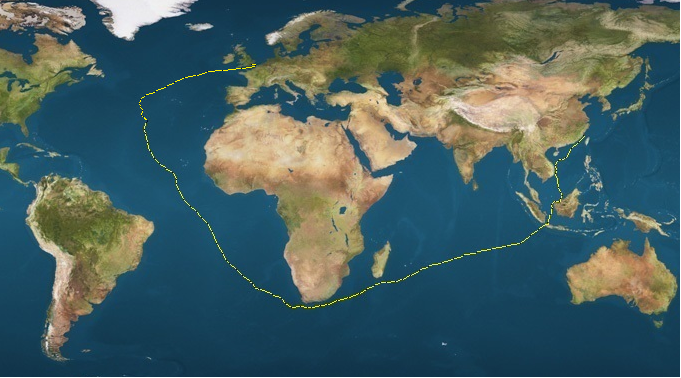
When steam, the Suez canal, and new tea plantations in India, Ceylon etc. made the the tea clippers obsolete, they started to transport wool from Australia... this time going east around the horn.
If you take the time to study the history of the clippers you'll appreciate that these voyages were matters of great public interest. Routes, exact times, everything about the voyages were and are well known. How did the clippers navigate? How did they make the distances in known times? How could this possibly be consistent with the FE map?
Then you have to start thinking about all of naval history for the last 500 years. How many commercial voyages were there in the 16th century, the 17th century, the 18th century, the 19th century, the 20th century? How many military voyages? How many yachts? Pirates even?
As of January 2016, there were 51,405 ships in the world's merchant fleets.
An interactive map for the year 2012: https://www.shipmap.org/
There must be a correct map. Otherwise ships would get hopelessly lost.
There must be a correct way to navigate: Otherwise ships would get hopelessly lost.
Only one map can be compatible to the known times, distances, and directions of millions of voyages.
No matter how you draw in the details in the flat earth map, this map is not compatible with the "mainstream" globe earth map. The differences are more extreme in the southern hemisphere, but even in the northern hemisphere the maps are not compatible.
How do you draw a FE map that is consistent with every known sea voyage? Make the continents a different shape and size to "shrink" the oceans? Then how do you make that consistent with all the land trips made inside the continents? Put the continents at different distances from one another to make a voyage between two of them (somewhat) consistent? Then inevitably you must be increasing the distance somewhere else. E.g. Australia, Africa and South America.
A web of millions of voyages, made by people who were just pragmatically trying to get around, has tested and verified the proper map.
Just one trivial example: The clipper ships. When there was a premium for the first new crop of tea from China, the clippers took this route:
When steam, the Suez canal, and new tea plantations in India, Ceylon etc. made the the tea clippers obsolete, they started to transport wool from Australia... this time going east around the horn.
If you take the time to study the history of the clippers you'll appreciate that these voyages were matters of great public interest. Routes, exact times, everything about the voyages were and are well known. How did the clippers navigate? How did they make the distances in known times? How could this possibly be consistent with the FE map?
Then you have to start thinking about all of naval history for the last 500 years. How many commercial voyages were there in the 16th century, the 17th century, the 18th century, the 19th century, the 20th century? How many military voyages? How many yachts? Pirates even?
As of January 2016, there were 51,405 ships in the world's merchant fleets.
An interactive map for the year 2012: https://www.shipmap.org/
There must be a correct map. Otherwise ships would get hopelessly lost.
There must be a correct way to navigate: Otherwise ships would get hopelessly lost.
Only one map can be compatible to the known times, distances, and directions of millions of voyages.
No matter how you draw in the details in the flat earth map, this map is not compatible with the "mainstream" globe earth map. The differences are more extreme in the southern hemisphere, but even in the northern hemisphere the maps are not compatible.
How do you draw a FE map that is consistent with every known sea voyage? Make the continents a different shape and size to "shrink" the oceans? Then how do you make that consistent with all the land trips made inside the continents? Put the continents at different distances from one another to make a voyage between two of them (somewhat) consistent? Then inevitably you must be increasing the distance somewhere else. E.g. Australia, Africa and South America.
A web of millions of voyages, made by people who were just pragmatically trying to get around, has tested and verified the proper map.
Last edited:
")