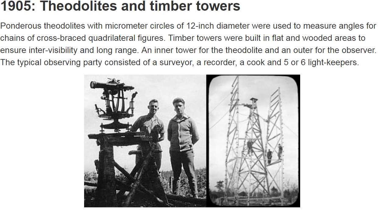
A theodolite is a relatively simple instrument for measuring vertical and horizontal angles. It's commonly used for surveying, but you can also use one to get a rough estimate of the curvature of the Earth by measuring how far the horizon falls below eye level from different altitudes.
Modern theodolites are now often digital and expensive, but the classic theodolite still works quite well for this purpose. A classic theodolite, like the Würdemann model seen above, consists of an adjustable base that you set to level with adjustment screws and spirit levels. You then use a telescope with a crosshair to sight the distant object (the horizon in our case) and then read off the angle of the telescope for the circular scale.
You can then measure the dip of the ocean horizon from various altitudes. While there's issues of visibility from waves (at very low altitudes) and haze (at higher altitudes), you should be able to get a good range of readings.
It struck me that while this is a great practical experiment to measure the curvature of the Earth (or simply to demonstrate that there is a curvature, for the Flat Earth folk) not many people have a theodolite.
Many people have a smart phone, and you can actually use a "theodolite" app to do simple measurements. Here's one I took from 36,000 feet showing the horizon dipping several degrees below level.
But the app is a little confusing to use for many people, and is not really that easy or accurate for measuring angles when you are below 1000 feet.
So I decided to try making a very simple "theodolite", which is basically a cheap 48 inch spirit level with a bit of cardboard stuck on the end. You rest this on something and adjust it so it is level. You then look along the top edge and see where the ocean horizon is relative to that. If the earth were flat then the ocean horizon would be in line with the top edge. Since it's not, we see the horizon dip below the top edge, and dip more as we get higher - indicating the ocean surface is curved.
For the very simplest experiment - demonstrating that there's a curve - we don't even need to use the bit of cardboard (although it's still helpful). All you have to do is set the level so it's level, and then look along it. If the horizon is below level then you have demonstrated the curvature of the ocean.
(I'm using a tripod here, but that's just for convenience, you can just put it on a wall or some other object, and adjust it to level by putting things underneath it.)
How do you "look along" the level? It works best if you are some distance behind it, so you can keep both ends (and the horizon) in sufficient focus to see where they all are. What you need is to get the top of the level so it's flat - which you can do by looking slightly to one side and seeing that the top side edge is in line with the top back edge.
Unfortunately I'm in a valley, so the surrounding ridges are above level for me, but we can still do measurements. I've marked the cardboard in 1/4" increments, and you can see that the "horizon" here is 3/4" above level.
What's that in degrees? It's relatively simple trigonometry since the eye, the end of the level, and the mark matching the horizon all form a nice triangle.
All you need to know is the distance from the eye (or preferably camera) position to the far end of the level. For simplicity I recommend making the distance to the near end the same same as the length of the level. Here I've got a 48" level, so I put my camera 48" behind it, giving a total distance of 96"
So, simply trig, the angle is arctan(height/distance) or arctan(0.75/96) in degrees = 0.45 degrees. I generally use Google as a calculator for things like this:
How accurate is this? Generally with a spirit level if you've got the bubble between the lines then that's level to better than 0.1°. Looking at the cardboard scale, if you've got a sharp horizon you can easily get better than 0.1" resolution, which is better than 0.05°. So with a little care you should be able to at least get accuracy of 0.1°, and probably several times that.
The expected values of the horizon dip are:
So with an accuracy better than 0.1° we should easily be able to roughly measure the dip of the ocean horizon even if we only have 400 feet (or less) to play with. Notice the change in the dip angle is most rapid when you are low down, the change from 100 to 1000 feet is about the same as from 30,000 to 40,000 feet.
While this is all mostly a fun science experiment. It's also an attempt by me to create a series of simple tests that anyone can do to detect the curvature of the earth - specifically aimed at people who believe the Earth is flat. That belief is only sustainable by rejecting all evidence from conventional authority (photos from space are generally dismissed as fake), and so the only evidence a hard-core flat earth believer will accept is the evidence of their own eyes.
Here I hope I have provided a means of simply getting that evidence. I'd encourage any flat earth believer who lives near the ocean to give it a go, and report back their results. If you find that the horizon does not always rise to eye level then perhaps that might lead to you doing some other experiments, and eventually figuring out the true shape of the Earth for yourself.
See also:
Last edited:


