2018 Hurricane Season and Weather Control Conspiracies

Mick West

Administrator
Staff member
Metabunk 2018-09-10 13-43-40.jpg


The most common conspiracy theory that accompanies a hurricane is that it has been "steered" to either hit a particular location or to miss a particular location. The theorists have kind of talked themselves into a corner as they continue to double down with each weather event. The theory seems to have expanded to the extent that the powers that be have an almost god-like control over the weather.

The reality is that nobody is even trying to control hurricanes any more. There were a few experiments back between 1962 and 1983 with Project Stormfury, but the results (focussing on simply reducing the strength of the hurricane winds) were inconclusive. The random nature of hurricanes without any modification was basically equally as random as the hurricanes where modification was attempted. Early results that seemed positive were simply where they happened to get lucky, but there was no statistical correlation.

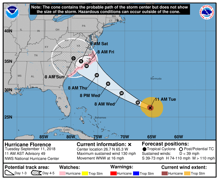
The diagram above shows the current "probable path" of the storm. It looks like a certain direct hit somewhere in North or South Carolina. But the path is only "probable", it's still possible that the Hurricane would diverge from these possible paths.


https://www.sfwmd.gov/weather-radar/hurricane-model-plots
Metabunk 2018-09-10 13-58-00.jpg


This storm has the potential to be the biggest one in the region in nearly 30 years. The last category 4 storm to make landfall in the Carolinas was Hurricane Hugo in 1989. Hugo took a similar path, a bit further south.
Metabunk 2018-09-10 14-04-36.jpg
 
Early results that seemed positive were simply where they happened to get lucky, but there was no statistical correlation.
Stormfury was the one where they seeded the inner rain bands to choke the eyewall, wasn't it? That was kind of an interesting read for me a few years ago - it actually contributed to the discovery of the Eyewall Replacement Cycle. The rain band they seeded expanded and formed a second eyewall, causing the inner one to weaken and the storm to lose rotation, which was taken initially as a sign of success. Then the seeded rain band formed a new eyewall and the storm became even stronger than before, which was taken as a sign of, "You done ****ed up, son."

Then the exact same process was observed happening naturally in similar conditions, and now know it's a natural process in very strong storms, and Stormfury probably didn't do anything at all.
 
The conspiracy tweets regarding Florence are already starting


Source: https://twitter.com/shpoondee/status/1039304591647682562


Source: https://twitter.com/prosepat/status/1039304609188249600


Source: https://twitter.com/WI_Chemtrails/status/1038494525445029889


The last one links to "AirCrap," which says:
https://www.aircrap.org/2018/09/08/hurricane-florence-engineered/
824a2f431d63e34de2a59b67d2cff121.jpg


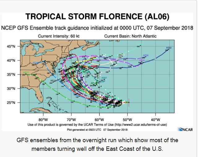
Here they take the forecasts from the 7th, and imply that since the forecast has changed this means the storm was "engineered" (even though there as some tracks that are close to the current forecast)
 
Weather manipulation is a very interesting subject, as are tropical cyclones. NOAA maintains a page on their Tropical Cyclone FAQ which covers various appearances of the idea in fiction, along with a section on 'Tropical cyclone Myths' which includes discussions of weather modification ideas including using nuclear weapons to manipulate the storm.

NOAA: TCFAQ C (Tropical Cyclone Modification and Myths)

http://www.aoml.noaa.gov/hrd/tcfaq/tcfaqC.html

NOAA: TCFAQ J4 (What fictional books, plays, poems, and movies have been written involving tropical cyclones?)

http://www.aoml.noaa.gov/hrd/tcfaq/J4.html

This second page includes several examples of weather modification in fiction, which may find their way into conspiracy theorists claims.
 
GFS has had a chronic problem of underestimating the depth of the Atlantic high pressure for a couple of years so it has a tendency to forecast cyclone tracks too far east and north. It did that with Irma, badly. US models had Irma east of FL in the 4-5 day forecast range. The official NHC forecast had Irma coming right up the east coast of FL in a blend of the GFS models and other global models. ECMWF and UKMET predicted Irma's path pretty damned well 5-days out. So far those two models are out-performing the other models on Florence. US NWS forecast models were late in predicting Hurricane Sandy's fusion with a frontal system and evolution into a nor'easter and retrograde track. Euro and UKMET predicted the Sandy track and transition into an-extra-tropical system >5 days out. GFS does a good job with non-tropical cyclones over the US but has done poorly at modeling the steering environment over the open Atlantic during the summer. There are a couple of good articles out there about US weather forecasting lagging UK and Europe in this department.
 
GFS has had a chronic problem of underestimating the depth of the Atlantic high pressure for a couple of years so it has a tendency to forecast cyclone tracks too far east and north. It did that with Irma, badly. US models had Irma east of FL in the 4-5 day forecast range. The official NHC forecast had Irma coming right up the east coast of FL in a blend of the GFS models and other global models. ECMWF and UKMET predicted Irma's path pretty damned well 5-days out. So far those two models are out-performing the other models on Florence. US NWS forecast models were late in predicting Hurricane Sandy's fusion with a frontal system and evolution into a nor'easter and retrograde track. Euro and UKMET predicted the Sandy track and transition into an-extra-tropical system >5 days out. GFS does a good job with non-tropical cyclones over the US but has done poorly at modeling the steering environment over the open Atlantic during the summer. There are a couple of good articles out there about US weather forecasting lagging UK and Europe in this department.

Comparison: ECMWF 20180911 00, vs GFS 20180911 06 (GFS is six hours newer than ECMWF)

[compare]
Metabunk 2018-09-11 09-06-51.jpg
Metabunk 2018-09-11 09-07-31.jpg

[/compare]
 
I've recently wondered between Trump supports vs detractors; how each perceive current "chemtrail" trends. Just speaking personally, my dad believes that chemtrail activity has decreased since Trump has taken office. So I wonder if a non-Trump support would think chemtrail activity has increased. I started Youtube searches a few days ago to find Hurricane Florence Haarp conspiracies...they're there, from emitting wifi to using microwaves to create disturbances off the coast of Africa.
 
Latest is people claiming that a "HAARP array" in Morehead City is steering the storm. They seem to think that the NEXRAD weather radar there is doing something more than surveiling the surrounding sky. There is also a lot of talk that the weakening over the last day or so is "engineered". The ones claiming that do not seem to understand the effect that the massive layer of dry air between 25k and 35k that is intruding into the south side of the storm is having. It disrupts the core convection and spawns convection away from the center of the circulation which disrupts the inflow of surface heat into the core of the storm. That makes the peak wind speed drop but also makes the wind field get wider so the center is less intense but the storm is more spread out. Means they won't likely see cat 3 or 4 winds on the coast but the storm surge will still be massive because the winds are affecting a broader patch of ocean. It could gain a little peak strength later today as the dry air layer retreats some to the southwest away from the main circulation. As I type this I've got the infrared and visible satellite images of the storm looping on the other screen and there is some really strong convection firing on the south side of the eye and it looks like less dry air being ingested than yesterday and last night.
 
Dane Wigington featured this theory recently on his website.

External Quote:
Every aspect of our weather is being altered and manipulated by geoengineering programs, including hurricanes / cyclones. Radio frequency / microwave transmission installations have been and are a core component of the ongoing global climate engineering operations. The 2+ minute video below tracks the path of Hurricane Florence while clearly revealing the network of radio frequency / microwave transmission facilities that were used to manipulate and steer this storm.
https://www.geoengineeringwatch.org...s-and-their-connection-to-hurricane-florence/

He featured a series of images that show something "blocking" the path of Hurricane Florence.
Still #1.png
Still #2.png


Another series images seems to imply that microwave transmitters are scattered across the country.
Still #3.png


None of these claims are particularly new.

What are those images in reality? Are they derived from a different source, like NOAA, and simply repurposed for Geoengineeringwatch.org? I don't have the expertise to know.
 
Those are weather surveillance radar images. Weather radar are ground based stations that emit radio waves (RAdio Detection And Ranging) and then measure the reflected energy to "see" what is in the air. They measure the intensity of the reflected energy, the distance to the stuff doing the reflecting, and the velocity (via a Doppler shift of the reflection) of the stuff. The base angle "looks" up at the sky at an angle of 0.5 degrees from the station and has a detection range of 125 or 250 nautical miles depending on the setting. It is a dish inside a dome that turns in a circle sweeping the sky every few minutes. When the images are looped it is basically a time lapse of still images.

The top two images that MikeG screen captured are single site images from the NWS radar in Raleigh.

The red one is "digital correlation coefficient" which is a fairly new product. The radar emits a signal in both a vertical and horizontal wave form (dual polarization) which allows the nature of the returned signal to discern precipitation from non-precipitation (birds, bats, dust, ash, etc...) reflections. A lot of display products for public consumption filter out the non-precipitation returns.
http://radarscope.tv/hrf_faq/correlation-coefficient-cc/

The other single image is the base reflectivity from the Raleigh radar. It shows a color coded map of the precipitation.

The bottom image is a mosaic of base reflectivity from all of the radars in the NWS network. It is basically a display of the raw data from all the radars in the NWS network projected onto a map. Precipitation from Florence is visible approaching the coast. The blobs around all of the individual radars in the eastern US are non-precipitation returns (fall night time bird migration in this case).

http://birdcast.info/live-migration-maps/
http://birdcast.info/scientific-discussion/tracking-the-dangerous-hurricane-florence/
http://birdcast.info/news/weather-surveillance-radar-beyond-meteorology/

Interesting thing last week. Florence kind of stopped up the east coast flyway once it was on shore. Then last week there was a flood of migration. Birds just poured into Florida Wednesday through Friday. Now they are hanging around waiting for a big front to come through and help them cross the Gulf of Mexico to their wintering grounds.
 
Rather than start a new thread for each Hurricane, let's use this thread for the 2018/2019 season.

This quote caught my eye, with Hurricane Michael:
Source: https://www.npr.org/2018/10/09/655734288/florida-braces-for-life-threatening-hurricane-michael-to-hit-panhandle-on-wednes

External Quote:

The Category 2 storm's rapid intensification "defies traditional logic," the National Hurricane Center says.
Which is exactly the type of thing that gets conspiracists going. The quote comes from one NHC discussion now archived:
https://www.nhc.noaa.gov/archive/2018/al14/al142018.discus.010.shtml?
External Quote:

Michael's steady intensification over the past 48 hours in the face
of 20-kt westerly shear defies traditional logic. Either the shear
calculations are unrepresentative or Michael has become more
inertially stable due to its large eye and large outer wind field,
making it more shear resistant. Having said that, all of the model
guidance calls for the shear to decrease to around 10 kt or less by
36 hours, which argues for at least steady intensification during
that time given that Michael will be moving over warm SSTs of
28.5C-29C, which are about 1-2 deg C above average for this time of
the year. Less-than-normal weakening after landfall in the 48-
to 96-h period is expected due to Michael's fast forward speed of
20-30 kt.
Translation: The opposing winds should be preventing it getting more intense, but they are not. Some error somewhere, or it's just really big. It's going to get worse, as there's less opposing wind later, and the water is warmer than normal.
 
I got clipped by Michael. Constant medium rain and gusts of wind but otherwise I've been through thunderstorms worse than this.
 
The fact that some buildings appear untouched, while others literally yards away are completely flattened also clearly indicates the use of Directed Energy (conspiracy theorists probably won't say).
 
Back
Top